ATL: Tropical Depression Dolly
Moderator: S2k Moderators


-
Smurfwicked
- Tropical Storm

- Posts: 164
- Age: 41
- Joined: Mon Sep 03, 2007 7:47 pm
- Location: SETX
Re: ATL: TS Dolly in Southern Gulf of Mexico
Hurricanewatcher2007 wrote:I don't think so. I could be wrong but I think the slower the speed the more time it has to build up the storm surge
Please note my example states 2 storms of identical strength with the only difference to how fast its moving.
My understanding is the faster its moving the more water it pulls along with it. I think this was also determined in the case of Katrina but then again I could be very wrong, I'm sure a pro met will be on here soon that might can verify or debunk this theory.
0 likes


Re: ATL: TS Dolly in Southern Gulf of Mexico
Smurfwicked wrote:Hurricanewatcher2007 wrote:I don't think so. I could be wrong but I think the slower the speed the more time it has to build up the storm surge
Please note my example states 2 storms of identical strength with the only difference to how fast its moving.
My understanding is the faster its moving the more water it pulls along with it. I think this was also determined in the case of Katrina but then again I could be very wrong, I'm sure a pro met will be on here soon that might can verify or debunk this theory.
It has to do with the windfield of the storm.
0 likes

Re: ATL: TS Dolly in Southern Gulf of Mexico
Smurfwicked wrote:Hurricanewatcher2007 wrote:I don't think so. I could be wrong but I think the slower the speed the more time it has to build up the storm surge
Please note my example states 2 storms of identical strength with the only difference to how fast its moving.
My understanding is the faster its moving the more water it pulls along with it. I think this was also determined in the case of Katrina but then again I could be very wrong, I'm sure a pro met will be on here soon that might can verify or debunk this theory.
I think storm surge has to do moreso with the expanse of the windfield...I'll give you examples of storms with the same strength (Relatively) with VASTLY different surges that hit two very surge prone areas.
1. Hurricane Katrina (125-140 mph, there is dispute) struck LA/MS moving somewhere between 9-13 mph. Surge was nearly 30 feet.
2. Hurricane Charley (150 mph) struck Punta Gorda and Port Charlotte racing near 20 mph. Surge was barely 7 feet.
Forward motion doesn't matter much, its the size that matters. And unfortunately Dolly seems to be a rather large system.
Oh and speaking of Dolly.......starting to get VERY worried about BRO and the potential for a major hurricane now. It is consolidating quite fast.
0 likes
Yeah the larger the systems windfield the greater the surge that will be developed, thats why smaller systems dont't pack quite a punch though in the gulf even strong small systems still have a pretty amazing surge.
Normandy, agreed Dolly finally looks like its got a CDO thats holding and so I suspect we will see steady strengthening from now on at the least and with 36-48hrs over water thats plenty of time to get a powerful hurricane out of this.
Normandy, agreed Dolly finally looks like its got a CDO thats holding and so I suspect we will see steady strengthening from now on at the least and with 36-48hrs over water thats plenty of time to get a powerful hurricane out of this.
Last edited by KWT on Tue Jul 22, 2008 5:26 am, edited 1 time in total.
0 likes
-
americanrebel
Re: ATL: TS Dolly in Southern Gulf of Mexico
Coastal Flood Statement
/O.CON.KLCH.CF.Y.0003.080722T1800Z- 080724T0600Z/ CAMERON-VERMILION-IBERIA- ST. MARY-JEFFERSON- 433 AM CDT TUE JUL 22 2008
...COASTAL FLOOD ADVISORY REMAINS IN EFFECT FROM 1 PM THIS AFTERNOON TO 1 AM CDT THURSDAY...
A COASTAL FLOOD ADVISORY REMAINS IN EFFECT FROM 1 PM THIS AFTERNOON TO 1 AM CDT THURSDAY.
TROPICAL STORM DOLLY IS EXPECTED TO MOVE WEST NORTHWEST ACROSS THE CENTRAL GULF...AND IS ANTICIPATED TO BECOME A HURRICANE BEFORE MAKING LANDFALL NEAR BROWNSVILLE TEXAS LATE WEDNESDAY.
WHILE TROPICAL STORM FORCE WINDS ARE NOT EXPECTED OVER THE NORTHWEST GULF WATERS...A LARGE AND PROLONGED EASTERLY FETCH OF WINDS OF 20 TO 25 KNOTS WILL OCCUR. THIS WILL GENERATE ABOVE NORMAL TIDES FOR COASTAL SOUTHEAST TEXAS AND SOUTHWEST LOUISIANA. TIDES WILL RUN FROM 1 TO 2 FEET ABOVE NORMAL WITH THE POTENTIAL FOR TOTAL TIDE VALUES OF 3 TO 3.5 FEET DURING HIGH TIDES FROM THIS AFTERNOON THROUGH LATE WEDNESDAY.
THE FOLLOWING TIDAL INFORMATION:
AT CAMERON TODAY...HIGH TIDE AT 6:12 AM...LOW TIDE AT 12:48 PM...HIGH TIDE AT 4:51 PM...AND LOW TIDE AT 11:48 PM.
AT SABINE PASS TODAY...HIGH TIDE AT 7: 08 AM...LOW TIDE AT 1:34 PM...AND HIGH TIDE AT 5:47 PM.
AT VERMILION BAY ON TODAY...HIGH TIDE AT 7:54 AM...LOW TIDE AT 1:39 PM...AND HIGH TIDE AT 6:33 PM.
AT STAGES OF 3 TO 3.5 FEET MLLW... SECTIONS OF HIGHWAY 87 BETWEEN PORT ARTHUR AND SABINE PASS IN JEFFERSON COUNTY TEXAS WILL HAVE WATER APPROACHING THE ROADWAY. ACROSS CAMERON PARISH...WATER WILL APPROACH HIGHWAY 82 WITH LOW SPOTS ACROSS THIS ROAD EXPERIENCING MINOR PUDDLING OF WATER. ACROSS THE REMAINDER OF VERMILION... IBERIA ...AND ST. MARY PARISHES...WATER WILL APPROACH SECONDARY PARISH ROADS.
This is just without her moving any further North, and if she will move further north, the Storm Surge could cause some problems.
0 likes


Re: ATL: TS Dolly in Southern Gulf of Mexico
Doesn't seem to have moved much in the last 5 hours, looking a the loops.
0 likes


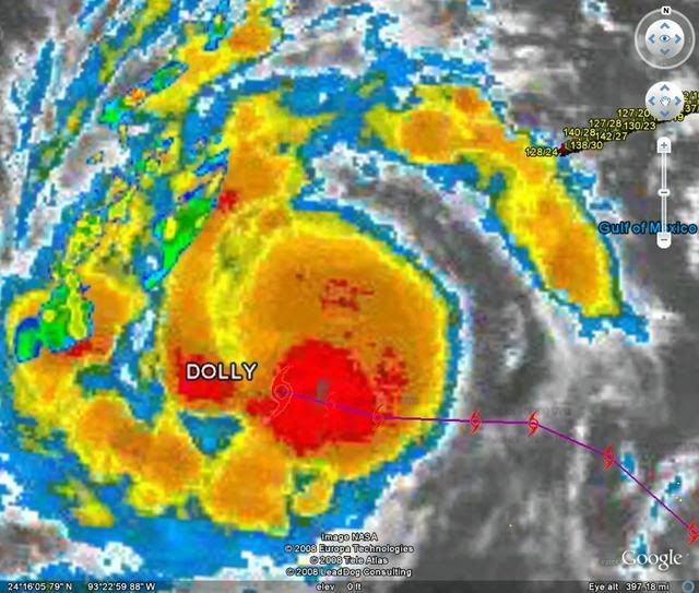
Re:
HURAKAN wrote:Look at that band!!!
Quite an impressive shot HURAKAN!
Our local Doppler is already showing spotted showers moving in and we are all the way up on the Northern Texas Coast. The rain will sure be a nice cool down treat! But I'm thankful for the high pressure protection.
0 likes
-
americanrebel
Re: ATL: TS Dolly in Southern Gulf of Mexico
http://www.weather.com/weather/map/7051 ... _plus_usen
This is already showing some of the bands coming into Louisiana
This is already showing some of the bands coming into Louisiana
0 likes
Yeah it does seem to have really slowed down recently which isn't good unless it totally stalls out which may allow eventual upwlling. However right now if it is going at 5-7mph that sshould be enough given its only a TS to stop that risk. The slower foward speed just gives Dolly even more time to strengthen.
Take a look at that structure, it surely is strengthening right now:
http://www.ssd.noaa.gov/goes/flt/t2/avn-l.jpg
Take a look at that structure, it surely is strengthening right now:
http://www.ssd.noaa.gov/goes/flt/t2/avn-l.jpg
0 likes
Re: ATL: TS Dolly in Southern Gulf of Mexico
Where can I find a loop that covers the last 24 hours or so?
0 likes
-
Air Force Met
- Military Met

- Posts: 4372
- Age: 57
- Joined: Tue Jul 08, 2003 9:30 am
- Location: Roan Mountain, TN
Re: ATL: TS Dolly in Southern Gulf of Mexico
Normandy wrote: Forward motion doesn't matter much, its the size that matters. And unfortunately Dolly seems to be a rather large system.
Forward motion does matter...but it depends on the basin. In some basins...a faster forward motion means less surge (like up Mobile Bay)...and in some...a faster forward motion means more surge...like the Pascagoula area or SE TX.
In Rio Grande area...speed makes little difference except near the mouth of the River...in which case a slower speed means a higher surge...on the order of a couple of feet.
OK...off to work.
0 likes
-
americanrebel
Re: ATL: TS Dolly in Southern Gulf of Mexico
From just looking at the Satellite looks like she could be a Cat. 1 hurricane, guess we will have to wait on RECON.
0 likes
Yeah thats fair enough. it does right now look more likely to be a Mexico hit right now unless it does take a NW track in the next 12hrs. The problem is even if it does hit Mexico Bro. will still very likely be in the northern eyewall which if anything will be even worse for them, esp if the system is only moving very slowly.
americanrebel, i'd personally go with 60kts right now and stay just shy of Cat-1 because whilst it does look like one it may take a little while for the winds to catch up.
americanrebel, i'd personally go with 60kts right now and stay just shy of Cat-1 because whilst it does look like one it may take a little while for the winds to catch up.
0 likes
-
Smurfwicked
- Tropical Storm
- Posts: 164
- Age: 41
- Joined: Mon Sep 03, 2007 7:47 pm
- Location: SETX
Re: ATL: TS Dolly in Southern Gulf of Mexico
Air Force Met wrote:Normandy wrote: Forward motion doesn't matter much, its the size that matters. And unfortunately Dolly seems to be a rather large system.
Forward motion does matter...but it depends on the basin. In some basins...a faster forward motion means less surge (like up Mobile Bay)...and in some...a faster forward motion means more surge...like the Pascagoula area or SE TX.
In Rio Grande area...speed makes little difference except near the mouth of the River...in which case a slower speed means a higher surge...on the order of a couple of feet.
OK...off to work.
Thanks for clarifying that AFM, looks like a few of us including me learned something from it
On another note, here in Beaumont right now I'm starting to hear thunder outside and our local radar is showing some scattered but dense areas of rain coming in off the gulf.
0 likes
-
HURAKAN

- Professional-Met

- Posts: 46084
- Age: 39
- Joined: Thu May 20, 2004 4:34 pm
- Location: Key West, FL
- Contact:
Loop: http://rammb.cira.colostate.edu/product ... 201355.GIF
Did Dolly hit a wall? Because it has slowdown a great deal. Wow.
Did Dolly hit a wall? Because it has slowdown a great deal. Wow.
0 likes
Who is online
Users browsing this forum: No registered users and 31 guests