ATL: IKE Discussion
Moderator: S2k Moderators
-
deltadog03

- Professional-Met

- Posts: 3580
- Joined: Tue Jul 05, 2005 6:16 pm
- Location: Macon, GA
Re: ATL IKE: Category 1 - Discussion
I see a weakness in the gom...We were talking about this earlier, there is part of the ridge just east of TX now, and the other is the big ridge in the ATL sprawled out. Models forecast a "weakness" for another 24-36 hours.
0 likes
-
TreasureIslandFLGal

- S2K Supporter

- Posts: 1584
- Age: 58
- Joined: Sun Aug 15, 2004 6:16 pm
- Location: Cancun, Mexico (northeast Yucatan coast)
Re: ATL IKE: Category 1 - Discussion
This is just my opinion, not endorsed by anyone and not professional. Always use NHC and your local EOC officials for guidance.
I think Ike might be feeling the weakness in the high just a little bit, and wouldn't be suprised to see more northwesterly jogs throughout the day. When looking at Ike from a more zoomed out image, you can see how the northern part fo the storm seems to be oozing slightly more to the north than in previous hours. The left side fo the storm appears squished, but merely because it isn't expanding as freely as the storm is to the north. In other words, the symmetry of Ike seems to be altering a bit and the northern part is extending slightly further than the rest of the storm.
When we have seen that sort of thing in the past, that often dictates the direction the storm intends to head. I believe that Ike may just try to feel that weakness a bit over the day...not much, but enough to alter the near term track, and I believe ultimately the landfall as well.
The weakness will quickly pass Ike by, but it will have a slight affect on the storm, with Ike missing forecast points to the north and east over the next 18 hours. Thereafter, I believe a more wnw to w path will ensue as the high builds back west and pushes Ike along.
The result of this though, in my opinion, is that Ike will strike Texas further north than indicatd by the models now, and gets back up near an aim more towards Houston. Additionally, I am not fully bought in to the idea that the incoming front won't affect Ike near the end of his run.
Earlier in the week, many models were seeing a lessening of steering flow occur when Ike gets into the mid gulf. Some still hint at that. I believe we will see a slow down of Ike, which may allow enough time for the front to become a factor, just barely too late to turn Ike more N and possibly NNE in the final analysis. Also, this slow down will only allow Ike to strengthen more. The stronger a storm, the more polebound it wants to go, and the more able to make its own weather environment. Although unable to go through a ridge, it may be able to lean a lot harder on it, assisting the more northerly element to its final path.
I am calling for a landfall more towards the north central texas gulf coast to just west of NOLA at this point. The longer a big slow down occurs, the more east Ike could make landfall. As we have seen in the Gulf, if anything is moving under 6 mph of forward motion, all bets are off! A significant stall could see this going into central LA coast.
-Chrissy
Last edited by TreasureIslandFLGal on Tue Sep 09, 2008 9:23 am, edited 1 time in total.
0 likes

Re: ATL IKE: Category 1 - Discussion
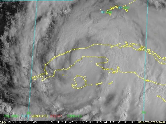
A double hit on the Sierra Los Organos, Cuba. Gus and Ike.
Climatology says hurricanes that go to Texas under a ridge at this time of year stay straight and don't recuve. The High that brought them west keeps them west.
Climatology says hurricanes that go to Texas under a ridge at this time of year stay straight and don't recuve. The High that brought them west keeps them west.
Last edited by Sanibel on Tue Sep 09, 2008 8:51 am, edited 1 time in total.
0 likes

CZ, yeah I agree with Derek I can't see the models shifting any further south then they are now and wouldn't be at all surprised if they eventually start to shift slightly north again.
Delta yeah thats the weakness that is going to induce the WNW motion over the next 48hrs, this is so key because once the high builds back in its likely to bend back to west or a shade north of west.
Delta yeah thats the weakness that is going to induce the WNW motion over the next 48hrs, this is so key because once the high builds back in its likely to bend back to west or a shade north of west.
0 likes
-
gatorcane

- S2K Supporter
- Posts: 23708
- Age: 48
- Joined: Sun Mar 13, 2005 3:54 pm
- Location: Boca Raton, FL
Re: ATL IKE: Category 1 - Discussion
deltadog03 wrote:I see a weakness in the gom...We were talking about this earlier, there is part of the ridge just east of TX now, and the other is the big ridge in the ATL sprawled out. Models forecast a "weakness" for another 24-36 hours.
The 00 UTC GFS doesn't see the weakness as given by the 000 500MB Vort:

Last edited by gatorcane on Tue Sep 09, 2008 8:51 am, edited 1 time in total.
0 likes
gatorcane, there is one there thats why the NHC are showing a WNW motion, its not very strong but its there. The fact the GFS doesn't do much with it is probably why the GFS is a little further south of some of the other models.
Its not a weakness per say its just where there is a bit of a break in the ridges IMO.
Its not a weakness per say its just where there is a bit of a break in the ridges IMO.
Last edited by KWT on Tue Sep 09, 2008 8:54 am, edited 1 time in total.
0 likes
-
tolakram
- Admin

- Posts: 20179
- Age: 62
- Joined: Sun Aug 27, 2006 8:23 pm
- Location: Florence, KY (name is Mark)
Re: ATL IKE: Category 1 - Discussion
Better late than ...

Personal Forecast Disclaimer:
The posts in this forum are NOT official forecast and should not be used as such. They are just the opinion of the poster and may or may not be backed by sound meteorological data. They are NOT endorsed by any professional institution or storm2k.org. For official information, please refer to the NHC and NWS products.
I believe that patch of mountains is what tore up Gustav. If Ike passes to the right of them then I see less core disruption. edit: But the direction Ike is heading now it appears he will pass directly over them.
Last edited by tolakram on Tue Sep 09, 2008 8:58 am, edited 1 time in total.
0 likes


Re: ATL IKE: Category 1 - Discussion
tolakram wrote:Better late than ...
Personal Forecast Disclaimer:
The posts in this forum are NOT official forecast and should not be used as such. They are just the opinion of the poster and may or may not be backed by sound meteorological data. They are NOT endorsed by any professional institution or storm2k.org. For official information, please refer to the NHC and NWS products.
I believe that patch of mountains is what tore up Gustav. If Ike passes to the right of them then I see less core disruption.
I think those are just some hills but you are right that it is not perfectly flat. Gustav also had less perfect conditions in addition to land to deal with.
0 likes
Re: ATL IKE: Category 1 - Discussion
If you look at the archives, storms that make it to Texas in September climatology tend to go straight in under the ridge that brought them:

0 likes


Re: ATL IKE: Category 1 - Discussion
So about 6 hours over land.... I think Ike will fare better than Gus did.
0 likes

-
Stormcenter
- S2K Supporter
- Posts: 6689
- Joined: Wed Sep 03, 2003 11:27 am
- Location: Houston, TX


-
tolakram
- Admin
- Posts: 20179
- Age: 62
- Joined: Sun Aug 27, 2006 8:23 pm
- Location: Florence, KY (name is Mark)
Re: ATL IKE: Category 1 - Discussion
They may not be huge but it appears the front end is very steep. Hurakan, any pictures of this area?

500m = 1640 ft
500m = 1640 ft
Last edited by tolakram on Tue Sep 09, 2008 9:03 am, edited 1 time in total.
0 likes

Re: ATL IKE: Category 1 - Discussion
TreasureIslandFLGal wrote:This is just my opinion, not endorsed by anyone and not professional. Always use NHC and your local EOC officials for guidance.
I think Ike might be feeling the weakness in the high just a little bit, and wouldn't be suprised to see more northwesterly jogs throughout the day. When looking at Ike from a more zoomed out image, you can see how the northern part fo the storm seems to be oozing slightly more to the north than in previous hours. The left side fo the storm appears squished, but merely because it isn't expanding as freely as the storm is to the north. In other words, the symmetry of Ike seems to be altering a bit and the northern part is extending slightly further than the rest of the storm.
When we have seen that sort of thing in the past, that often dictates the direction the storm intends to head. I believe that Ike may just try to feel that weakness a bit over the day...not much, but enough to alter the near term track, and I believe ultimately the landfall as well.
The weakness will quickly pass Ike by, but it will have a slight affect on the storm, with Ike missing forecast points to the north and east over the next 18 hours. Thereafter, I believe a more wnw to w path will ensue as the high builds back west and pushes Ike along.
The result of this though, in my opinion, is that Ike will strike Texas further north than indicatd by the models now, and gets back up near an aim more towards Houston. Additionally, I am not fully bought in to the idea that the incoming front won't affect Ike near the end of his run.
Earlier in the week, many models were seeing a lessening of steering flow occur when Ike gets into the mid gulf. Some still hint at that. I believe we will see a slow down of Ike, which may allow enough time for the front to become a factor, just barely too late to turn Ike more N and possibly NNE in the final analysis. Also, this slow down will only allow Ike to strengthen more. The stronger a storm, the more polebound it wants to go, and the more able to make its own weather environment. Allow unable to go through a ridge, it may be able to lean a lot harder on it, assisting the more northerly element to its final path.
I am calling for a landfall more towards the north central texas gulf coast to just west of NOLA at this point. The longer a big slow down occurs, the more east Ike could make landfall. As we have seen in the Gulf, if anything is moving under 6 mph of forward motion, all bets are off! A significant stall could see this going into central LA coast.
-Chrissy
This is getting so frustatring on where this thing will go. I really want to leave Houston and go to Ft Lauderdale tomorrow, however I don't know if I can get back home before the storm or on Sunday as scheduled. Uggggghhhhhh, I want to pull my hair out over this. I went and bought a window A/C last night hoping that would keep him away, I am fully prepared so why is he still coming to Texas. I honestly believe he will make landfall somewhere around Matagorda, right now my stomach feels like Ike looks.
Shannon
0 likes
-
deltadog03
- Professional-Met
- Posts: 3580
- Joined: Tue Jul 05, 2005 6:16 pm
- Location: Macon, GA
Re: ATL IKE: Category 1 - Discussion
Well, to be fair, gustav didn't have a trof that is forecasted to be very close to picking him up either.... 
0 likes
Who is online
Users browsing this forum: No registered users and 25 guests