ATL: IKE Discussion
Moderator: S2k Moderators
-
dolebot_Broward_NW
- Category 2

- Posts: 529
- Joined: Fri Sep 10, 2004 6:38 am

Re: ATL IKE: Category 1 - Discussion
On the steering winds, here is a classic example of a stronger storm getting pulled more poleward. I attached the 940-949 mb storm pressure steering - as you can see, the weakness or COL is more pronouned between the bubble high in the western GOM and the atlantic ridge east of FL. Go to the steering for a storm at less than 940 mb, and that weakness is even larger with steering generally toward the north. You can also see that that the currents are very light which will also cause Ike to slow down.
Current Steering 950mb-969mb
http://cimss.ssec.wisc.edu/tropic/real-time/atlantic/winds/wg8dlm4.html
940-949 mb steering
http://cimss.ssec.wisc.edu/tropic/real-time/atlantic/winds/wg8dlm5.html
<940 mb steering
http://cimss.ssec.wisc.edu/tropic/real-time/atlantic/winds/wg8dlm6.html
Current Steering 950mb-969mb
http://cimss.ssec.wisc.edu/tropic/real-time/atlantic/winds/wg8dlm4.html
940-949 mb steering
http://cimss.ssec.wisc.edu/tropic/real-time/atlantic/winds/wg8dlm5.html
<940 mb steering
http://cimss.ssec.wisc.edu/tropic/real-time/atlantic/winds/wg8dlm6.html
Last edited by ronjon on Tue Sep 09, 2008 9:47 am, edited 1 time in total.
0 likes
-
O Town
- S2K Supporter

- Posts: 5205
- Age: 52
- Joined: Wed Sep 07, 2005 9:37 pm
- Location: Orlando, Florida 28°35'35"N 81°22'55"W
Re:
dolebot_Broward_NW wrote:What is the proper steering layer for Ike now that hes a CAT1?
Check out the link below, it will tell you in the boxes up top which is best to use when.
http://cimss.ssec.wisc.edu/tropic2/real ... oom=&time=
0 likes
-
Blown Away

- S2K Supporter
- Posts: 10253
- Joined: Wed May 26, 2004 6:17 am
Re: ATL IKE: Category 1 - Discussion
Ed Mahmoud wrote:JB says near CRP, but he had Ike hitting NYC last week, and CRP just happens to be the biggest city between Tampico and Houston.
He could be right.
I think he has nailed every major Atlantic/Gulf city so far.
0 likes

Re: ATL IKE: Category 1 - Discussion
Ed Mahmoud wrote:JB says near CRP, but he had Ike hitting NYC last week, and CRP just happens to be the biggest city between Tampico and Houston.
He could be right.
Well it seems pretty reasonable, I'll be a little surprised if Ike goes quite as far south as the GFS is expecting but its possible who knows. This is one of those set-ups where we really need Ike to hit somewhere with low population density because I've got a nasty feeling Ike is going to be a gulf beast.
0 likes
-
Tireman4

- S2K Supporter
- Posts: 5903
- Age: 60
- Joined: Fri Jun 30, 2006 1:08 pm
- Location: Humble, Texas
- Contact:
Re: Re:
jasons wrote:
I encourage anyone on the TX coast to read this.
I agree with Jeff - and I still cannot shake Rita. I think the models have bottomed-out to the left and will now gradually shift right. This is what AFM laid out yesterday and I'm sticking to my guns for now.
Side note: wow, those pics are beautiful. If only we could visit there....
Again, I agree with you Jason. Everyone should pay attention to this. AFM called it. He stated that the models would trend northward after bottoming out.
0 likes
-
O Town
- S2K Supporter
- Posts: 5205
- Age: 52
- Joined: Wed Sep 07, 2005 9:37 pm
- Location: Orlando, Florida 28°35'35"N 81°22'55"W
Re: Re:
O Town wrote:dolebot_Broward_NW wrote:What is the proper steering layer for Ike now that hes a CAT1?
Check out the link below, it will tell you in the boxes up top which is best to use when.
http://cimss.ssec.wisc.edu/tropic2/real ... oom=&time=
Except that is for Europe. LOL
Heres the link for the N. Atlantic.
http://cimss.ssec.wisc.edu/tropic2/real ... oom=&time=
0 likes
-
jlauderdal
- S2K Supporter
- Posts: 7240
- Joined: Wed May 19, 2004 5:46 am
- Location: NE Fort Lauderdale
- Contact:
Re: ATL IKE: Category 1 - Discussion
Blown_away wrote:Ed Mahmoud wrote:JB says near CRP, but he had Ike hitting NYC last week, and CRP just happens to be the biggest city between Tampico and Houston.
He could be right.
I think he has nailed every major Atlantic/Gulf city so far.
yep, after the fourth revision to the original
0 likes
-
DESTRUCTION5

- Category 5

- Posts: 4430
- Age: 44
- Joined: Wed Sep 03, 2003 11:25 am
- Location: Stuart, FL
Re: ATL IKE: Category 1 - Discussion
ronjon wrote:On the steering winds, here is a classic example of a stronger storm getting pulled more poleward. I attached the 940-949 mb storm pressure steering - as you can see, the weakness or COL is more pronouned between the bubble high in the western GOM and the atlantic ridge east of FL. Go to the steering for a storm at less than 940 mb, and that weakness is even larger with steering generally toward the north. You can also see that that the currents are very light which will also cause Ike to slow down.
Current Steering 950mb-969mb
http://cimss.ssec.wisc.edu/tropic/real-time/atlantic/winds/wg8dlm4.html
940-949 mb steering
http://cimss.ssec.wisc.edu/tropic/real-time/atlantic/winds/wg8dlm5.html
<940 mb steering
http://cimss.ssec.wisc.edu/tropic/real-time/atlantic/winds/wg8dlm6.html
So in theory your saying if Cuba was not there to weaken him this would be haeaded to the N gulf coast?
0 likes

Re: ATL IKE: Category 1 - Discussion
ronjon wrote:On the steering winds, here is a classic example of a stronger storm getting pulled more poleward. I attached the 940-949 mb storm pressure steering - as you can see, the weakness or COL is more pronouned between the bubble high in the western GOM and the atlantic ridge east of FL. Go to the steering for a storm at less than 940 mb, and that weakness is even larger with steering generally toward the north. You can also see that that the currents are very light which will also cause Ike to slow down.
Current Steering 950mb-969mb
http://cimss.ssec.wisc.edu/tropic/real-time/atlantic/winds/wg8dlm4.html
940-949 mb steering
http://cimss.ssec.wisc.edu/tropic/real-time/atlantic/winds/wg8dlm5.html
<940 mb steering
http://cimss.ssec.wisc.edu/tropic/real-time/atlantic/winds/wg8dlm6.html
with what I see here could this even be a Florida storm possibly and if not please show me or tell me how I can tell that. Thanks, just wanting to learn.
0 likes
AFM said the NHC track would move south two more runs and then begin tracking north. Well, I would be surprised if the NHC bumped track a little more south for the fourth run in a row.
Models have not jumped north, sans a few outliers, but there are southern outliers as well.
24 hours from now, we should have a better idea of what we are dealing with.
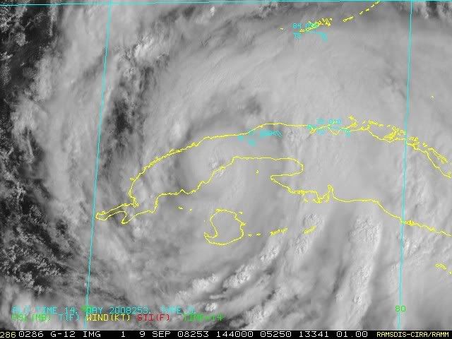
On a side note, it appears the IKe could spend a few hours inland over Cuba, hopefully some weakening can occur.
Models have not jumped north, sans a few outliers, but there are southern outliers as well.
24 hours from now, we should have a better idea of what we are dealing with.
On a side note, it appears the IKe could spend a few hours inland over Cuba, hopefully some weakening can occur.
0 likes
I think the best thing to do for those in Texas is to just watch what Ike does in the next 48hrs, that will go a long way into solving the issues, because that appears to be where the main difference is with many of the models.
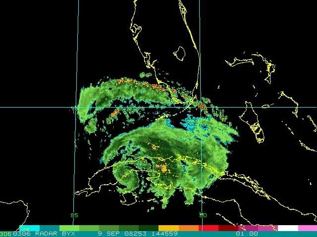
Anyway much of the inner core now including the eye is over Cuba, I'd guess around 6hrs till its back in the gulf. I'm not expecting very rapid strengthening right away as it'll have to redjust its inner core again but when it does conditions looking good for this to be a major hurricane yet again...
Anyway much of the inner core now including the eye is over Cuba, I'd guess around 6hrs till its back in the gulf. I'm not expecting very rapid strengthening right away as it'll have to redjust its inner core again but when it does conditions looking good for this to be a major hurricane yet again...
0 likes


-
Air Force Met
- Military Met

- Posts: 4372
- Age: 57
- Joined: Tue Jul 08, 2003 9:30 am
- Location: Roan Mountain, TN
Re: ATL IKE: Category 1 - Discussion
jlauderdal wrote:deltadog03 wrote:COL dosn't mean cut off low...COL is an area btwn 2 highs....You can clearly see the weakness. Now, once this starts to strengthen it should pick up steam and head right towards that weakness...
we need to get this clear for the board, maybe afm was referring to something else, whats your definition of COL
The structure and evolution of an intense tropical cut-off low (COL)
I wasn''t referring to anything different. I accidentally took out one of the quotes. If you will go back and read my entire post...you will realize I was quoting you and then I answered. Problem is it didn't show yours in quotes.
A COL is a saddlepoint of weakness in the wind (or pressure) field b/w the ridges and lows.
0 likes
-
Nederlander
- S2K Supporter
- Posts: 1259
- Joined: Sat Jul 19, 2008 4:28 pm
- Location: Conroe, TX
Re: ATL IKE: Category 1 - Discussion
artist wrote:ronjon wrote:On the steering winds, here is a classic example of a stronger storm getting pulled more poleward. I attached the 940-949 mb storm pressure steering - as you can see, the weakness or COL is more pronouned between the bubble high in the western GOM and the atlantic ridge east of FL. Go to the steering for a storm at less than 940 mb, and that weakness is even larger with steering generally toward the north. You can also see that that the currents are very light which will also cause Ike to slow down.
Current Steering 950mb-969mb
http://cimss.ssec.wisc.edu/tropic/real-time/atlantic/winds/wg8dlm4.html
940-949 mb steering
http://cimss.ssec.wisc.edu/tropic/real-time/atlantic/winds/wg8dlm5.html
<940 mb steering
http://cimss.ssec.wisc.edu/tropic/real-time/atlantic/winds/wg8dlm6.html
with what I see here could this even be a Florida storm possibly and if not please show me or tell me how I can tell that. Thanks, just wanting to learn.
the weakness will be enough to pull Ike more NW in the short term, say the next 24-36 hours, and then the ridge is forecast to build back in forcing Ike West. The main question is the trof coming down from W Canada... timing is what its all about... any deviations in speed of either the trof or Ike could impact landfall... also another thing to look at is how far south that trof gets...
0 likes
NHC shifts to the right and slows down
http://www.wunderground.com/tropical/at ... ml#a_topad
http://www.wunderground.com/tropical/at ... ml#a_topad
0 likes
Re:
dwg71 wrote:
On a side note, it appears the IKe could spend a few hours inland over Cuba, hopefully some weakening can occur.
Hopefully but I wouldn't get too hopeful for it to weaken much more then say down to 65kts given how short the trip will be. The inner core will weaken but given it survived a much longer trek with an outer eyewall as well suggests this little trek across land won't cause anything too drastic.
Hurakan, that is a really impressive presentation for a cat-1, I wouldn't be all that surprised if the NE quadrant has winds higher then 70kts.
0 likes
-
Air Force Met
- Military Met
- Posts: 4372
- Age: 57
- Joined: Tue Jul 08, 2003 9:30 am
- Location: Roan Mountain, TN
Re:
dwg71 wrote:AFM said the NHC track would move south two more runs and then begin tracking north. Well, I would be surprised if the NHC bumped track a little more south for the fourth run in a row.
Models have not jumped north, sans a few outliers, but there are southern outliers as well.
24 hours from now, we should have a better idea of what we are dealing with.
On a side note, it appears the IKe could spend a few hours inland over Cuba, hopefully some weakening can occur.
Latest advisory has landfall 50 miles up the coast.
0 likes

Re:
dwg71 wrote:AFM said the NHC track would move south two more runs and then begin tracking north. Well, I would be surprised if the NHC bumped track a little more south for the fourth run in a row.
Models have not jumped north, sans a few outliers, but there are southern outliers as well.
24 hours from now, we should have a better idea of what we are dealing with.
On a side note, it appears the IKe could spend a few hours inland over Cuba, hopefully some weakening can occur.
Of course I disagree with you....
The GFS,GFDL,HWRF, all have followed the EURO (trend setter so far) no sound reasoning to discount this now.
0 likes
Who is online
Users browsing this forum: No registered users and 25 guests