ATL GUSTAV: Tropical Depression - Discussion

Moderator: S2k Moderators

Message
Author
User avatar
mvtrucking
S2K Supporter
S2K Supporter
Posts: 698
Age: 67
Joined: Sat Jul 09, 2005 10:01 am
Location: Monroe,La

Re: Cat. 4 Hurricane Gustav in NW Caribbean Sea

#6881 Postby mvtrucking » Sat Aug 30, 2008 12:52 pm

Air Force Met wrote:
Brent wrote:Not much to say here.


Yes there is...and this may get me in trouble...but anyone who did not forecast (pro's here) the potential for a high end Cat 3 or low end cat 4...AT LEAST...over the NW Caribbean and headed for Cuba YESTERDAY...really doesn't need to be forecasting. I suggest they put the models down and look at some freaking basic synoptics and be a forecaster instead of a model reader. Been telling my customer for 2 days this was going to happen...not based on any model but just good analysis of the situation. Forecasting a Cat 1 and Cat 2 yesterday over this part of the ocean was just bad forecasting.

There. I said it. Its off my chest. I vented. I can't say much more than that. Slam if you wish...but I really don't care.


Hey hopefully you feel better AFM.(Sometimes t helps) Back on topic, any new thoughts on the storm AFM? Thanks in advance.
0 likes   

User avatar
WindRunner
Category 5
Category 5
Posts: 5806
Age: 34
Joined: Fri Jul 29, 2005 8:07 pm
Location: Warrenton, VA, but Albany, NY for school
Contact:

Re: Cat. 4 Hurricane Gustav in NW Caribbean Sea

#6882 Postby WindRunner » Sat Aug 30, 2008 12:53 pm

Air Force Met wrote:
Brent wrote:Not much to say here.


Yes there is...and this may get me in trouble...but anyone who did not forecast (pro's here) the potential for a high end Cat 3 or low end cat 4...AT LEAST...over the NW Caribbean and headed for Cuba YESTERDAY...really doesn't need to be forecasting. I suggest they put the models down and look at some freaking basic synoptics and be a forecaster instead of a model reader. Been telling my customer for 2 days this was going to happen...not based on any model but just good analysis of the situation. Forecasting a Cat 1 and Cat 2 yesterday over this part of the ocean was just bad forecasting.

There. I said it. Its off my chest. I vented. I can't say much more than that. Slam if you wish...but I really don't care.


Exactly...this is one of the problems with TC forecasting and RI cycles today. It's fine to forecast some intensification even if the models are not, but yet to supposedly "play it safe" and go with the conservative models - while looking better/smarter in the long run, especially if it doesn't actually verify - is just foolish. Granted, you also have to play on the public perception of things, and the whole "crying wolf" scenario...but in that sense, forecasters today are too afraid...and, without naming names, certain specialists exhibit this moreso than others and it's really kinda frustrating when everyone knows that a storm is almost certainly going to strengthen more than the official forecast. But, unfortunately, there is not much we can do about that at this point in time.
0 likes   

User avatar
PTPatrick
Category 5
Category 5
Posts: 1831
Joined: Sat Jun 12, 2004 8:38 am

Re: Cat. 4 Hurricane Gustav in NW Caribbean Sea

#6883 Postby PTPatrick » Sat Aug 30, 2008 12:53 pm

so far CMC and UKMET 12Z's re Terrebone/LaFourche Parrish landfalls. The resolution isnt great enough to see which one exactly...but suffice it to say they are NOT in or west of Vermillion Bay. Although CMC looks to have landfall a hair furhter east and at 60 hours instead of 72 as the UKMET shows. CMC goes stright to Shreveport. UKMET loops back through Lafayette and Vermillion Bay and heads back SW to menace the Upper the texas coast...
0 likes   

User avatar
HURAKAN
Professional-Met
Professional-Met
Posts: 46086
Age: 38
Joined: Thu May 20, 2004 4:34 pm
Location: Key West, FL
Contact:

#6884 Postby HURAKAN » Sat Aug 30, 2008 12:56 pm

Image
0 likes   

Air Force Met
Military Met
Military Met
Posts: 4372
Age: 56
Joined: Tue Jul 08, 2003 9:30 am
Location: Roan Mountain, TN

Re: Re:

#6885 Postby Air Force Met » Sat Aug 30, 2008 12:57 pm

CrazyC83 wrote:
Just Joshing You wrote:WOW Just checked back in.. Cat 4 145 MPH!? Joe Bastardi said Cat 5 landfall in Cuba.. Oh my gosh I am speechless.


Before you start eating the crow, remember that many of us on here were predicting such.


Yep...and I know JB loses some...but he also wins some. So all the "eye-roll" posters who do that when he predicts a cat 4 or 5 nearing Cuba need to stop. IMO.
0 likes   

User avatar
karenfromheaven
Tropical Storm
Tropical Storm
Posts: 171
Age: 71
Joined: Thu Sep 09, 2004 4:45 pm
Location: North Naples, FL

Re: Cat. 4 Hurricane Gustav in NW Caribbean Sea

#6886 Postby karenfromheaven » Sat Aug 30, 2008 1:01 pm

I've been searching for SLOSH model runs of any kind for the NO area, and the best I've come up with so far is a plot from the NOAA Extratropical Surge site. Here is an image capture of the tide and surge forecast for Grand Isle Point:
Image
You can see the current forecast at http://www.weather.gov/mdl/etsurge/index.htm?coast=gulf&stn=lariga&type=both. They say they base their calculations on the latest GFS run. Doesn't a 4 foot surge seem a little low? I have used this site in past storms to monitor tides and surges in Panama City, and it has been remarkably accurate. Now here is the plot for Sabine Pass TX, and as you might expect, it shows how the storm arriving to the east causes water to be blown offshore by the winds from the north, resulting in a "negative" surge:
Image
It would be nice if they offered some other observation points along the coast, but I imagine they are costly to set up and maintain. I watched the Waveland station during Katrina, and I could see the surge start to arrive, but the station failed before the surge crested.
0 likes   

User avatar
WmE
Category 2
Category 2
Posts: 696
Age: 36
Joined: Sat Jun 17, 2006 11:23 am
Location: Vienna, Austria

#6887 Postby WmE » Sat Aug 30, 2008 1:03 pm

Wow, NHC now predicting a Cat 5 on the gulf.
0 likes   

User avatar
Hurricanewatcher2007
Category 2
Category 2
Posts: 578
Joined: Sat Jul 05, 2008 8:10 pm

Re: Cat. 4 Hurricane Gustav in NW Caribbean Sea

#6888 Postby Hurricanewatcher2007 » Sat Aug 30, 2008 1:04 pm

the NHC is now forecast a cat 5 in the gulf! Here we go! at least in 2005 every time the NHC forecasted a cat 5 it always happened!

FORECAST VALID 31/1200Z 24.3N 85.4W
MAX WIND 140 KT...GUSTS 170 KT.
64 KT... 50NE 40SE 30SW 40NW.
50 KT... 90NE 90SE 60SW 90NW.
34 KT...160NE 125SE 100SW 125NW.
0 likes   

otowntiger
Category 5
Category 5
Posts: 1927
Joined: Tue Aug 31, 2004 7:06 pm

Re: Cat. 4 Hurricane Gustav in NW Caribbean Sea

#6889 Postby otowntiger » Sat Aug 30, 2008 1:04 pm

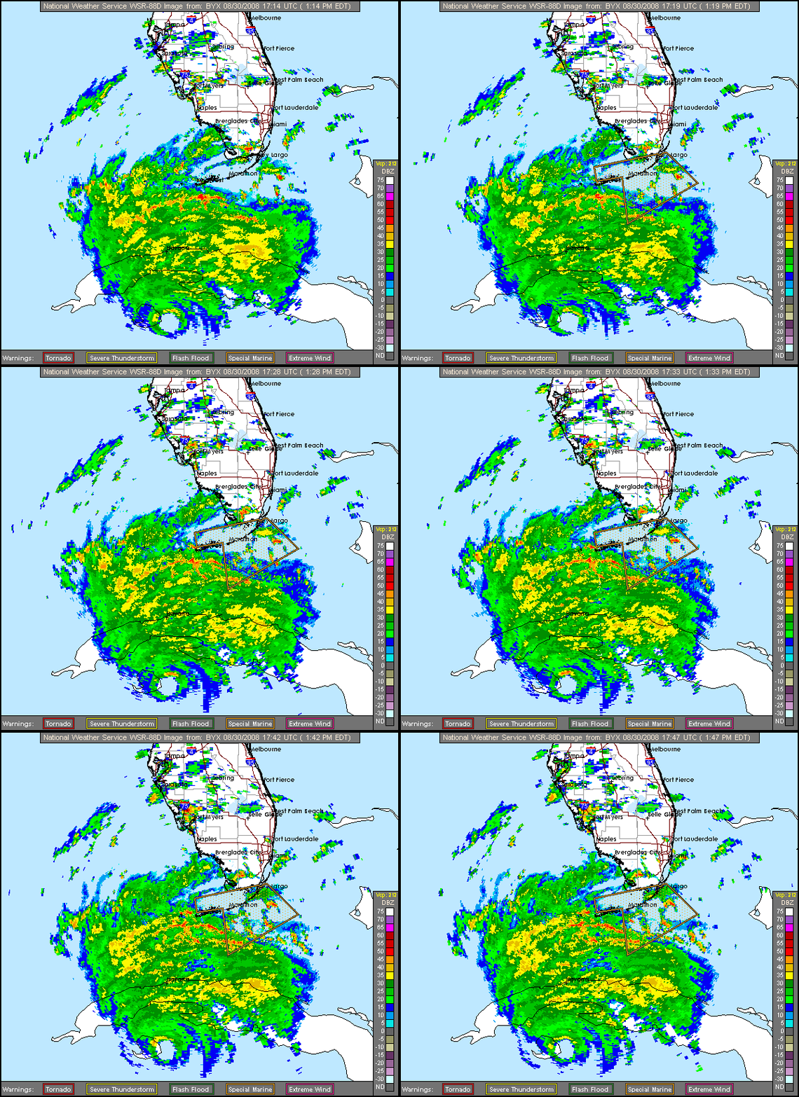
We've been getting pounding tropical like downpours here with some gusty winds for the last several hours here in Orlando. Looking at the sattellite it appears that we are definitely feeling the affects of Gustav way up here and they aren't minor affects at that. We still have rising flood waters in some places esp. up the St. Johns River and this kind of rain will not help. The weather we are getting also speaks to the expansion of this storm. Could Gustav be another Katrina in terms of size?
Last edited by otowntiger on Sat Aug 30, 2008 1:06 pm, edited 1 time in total.
0 likes   

User avatar
cycloneye
Admin
Admin
Posts: 146244
Age: 69
Joined: Thu Oct 10, 2002 10:54 am
Location: San Juan, Puerto Rico

Re: Cat. 4 Hurricane Gustav in NW Caribbean Sea

#6890 Postby cycloneye » Sat Aug 30, 2008 1:05 pm

FORECAST VALID 31/1200Z 24.3N 85.4W
MAX WIND 140 KT...GUSTS 170 KT.
64 KT... 50NE 40SE 30SW 40NW.
50 KT... 90NE 90SE 60SW 90NW.
34 KT...160NE 125SE 100SW 125NW.

MAX WIND 135 KT...GUSTS 165 KT.
64 KT... 60NE 50SE 40SW 50NW.
50 KT... 90NE 90SE 60SW 90NW.
34 KT...160NE 140SE 100SW 140NW.

FORECAST VALID 01/1200Z 27.8N 89.2W
MAX WIND 125 KT...GUSTS 150 KT.
50 KT... 90NE 90SE 60SW 90NW.
34 KT...160NE 140SE 100SW 140NW.

FORECAST VALID 02/1200Z 30.5N 92.5W...INLAND
MAX WIND 80 KT...GUSTS 100 KT.
50 KT... 50NE 50SE 30SW 50NW.
34 KT...100NE 100SE 75SW 90NW.
0 likes   

cpdaman
Category 5
Category 5
Posts: 3131
Joined: Sat Jun 10, 2006 11:44 am
Location: SPB county (gulf stream)

Re: Cat. 4 Hurricane Gustav in NW Caribbean Sea

#6891 Postby cpdaman » Sat Aug 30, 2008 1:05 pm

karenfromheaven wrote:I've been searching for SLOSH model runs of any kind for the NO area, and the best I've come up with so far is a plot from the NOAA Extratropical Surge site. Here is an image capture of the tide and surge forecast for Grand Isle Point:
Image
You can see the current forecast at http://www.weather.gov/mdl/etsurge/index.htm?coast=gulf&stn=lariga&type=both. They say they base their calculations on the latest GFS run. Doesn't a 4 foot surge seem a little low? I have used this site in past storms to monitor tides and surges in Panama City, and it has been remarkably accurate. Now here is the plot for Sabine Pass TX, and as you might expect, it shows how the storm arriving to the east causes water to be blown offshore by the winds from the north, resulting in a "negative" surge:
Image
It would be nice if they offered some other observation points along the coast, but I imagine they are costly to set up and maintain. I watched the Waveland station during Katrina, and I could see the surge start to arrive, but the station failed before the surge crested.


karen here's my take

gustav is still a relatively compact storm, these storms can have very high surges (see camile) but the effect is much more localized (over less total shore area) so this model is probably based on a landfall to the west, where as should the landfall point be 50 miles east, it would be up over 15 feet (assuming cat 3) any pro's can slap me or pat me on the back
Last edited by cpdaman on Sat Aug 30, 2008 1:06 pm, edited 1 time in total.
0 likes   

jinftl
Category 5
Category 5
Posts: 4312
Joined: Tue Aug 31, 2004 4:47 pm
Location: fort lauderdale, fl

Re: Cat. 4 Hurricane Gustav in NW Caribbean Sea

#6892 Postby jinftl » Sat Aug 30, 2008 1:05 pm

Please keep in mind that although the core of worst winds may stay west....the impact of a Cat 4 surge that is now developing is starting to concern me greatly. That would be alot of water pushing north....and will be a test for the levees that is very very very scary.

The surge threat is greater than the wind threat...and that doesn't require a head-on landfall to rear its effects.

Blown_away wrote:If Gustav follows the NHC track, she should be far enough W to keep N.O. from the core center. Looking at the map N.O. would be 50-75 miles E from the center. Still have to prepare for the worst but the current track should keep the Cat 2+ winds from N.O., am I correct.
0 likes   

User avatar
WindRunner
Category 5
Category 5
Posts: 5806
Age: 34
Joined: Fri Jul 29, 2005 8:07 pm
Location: Warrenton, VA, but Albany, NY for school
Contact:

Re: Cat. 4 Hurricane Gustav in NW Caribbean Sea

#6893 Postby WindRunner » Sat Aug 30, 2008 1:06 pm

karenfromheaven wrote:I've been searching for SLOSH model runs of any kind for the NO area, and the best I've come up with so far is a plot from the NOAA Extratropical Surge site. Here is an image capture of the tide and surge forecast for Grand Isle Point:

You can see the current forecast at http://www.weather.gov/mdl/etsurge/index.htm?coast=gulf&stn=lariga&type=both. They say they base their calculations on the latest GFS run. Doesn't a 4 foot surge seem a little low? I have used this site in past storms to monitor tides and surges in Panama City, and it has been remarkably accurate. Now here is the plot for Sabine Pass TX, and as you might expect, it shows how the storm arriving to the east causes water to be blown offshore by the winds from the north, resulting in a "negative" surge:

It would be nice if they offered some other observation points along the coast, but I imagine they are costly to set up and maintain. I watched the Waveland station during Katrina, and I could see the surge start to arrive, but the station failed before the surge crested.


Part of the problem is that, as you said, it's based off the GFS. GFS is not high enough resolution to show the correct wind speeds associated with this system, and this lack of true winds accumulated over the next 3-4 days results in such a low model-resolution surge. Trust me, true surge values would be much higher.
0 likes   

User avatar
WhirlWind
Tropical Storm
Tropical Storm
Posts: 104
Age: 66
Joined: Sat Oct 12, 2002 9:04 pm
Location: Lehigh Acres, Florida
Contact:

#6894 Postby WhirlWind » Sat Aug 30, 2008 1:06 pm

Here in Lehigh Acres, Fl. we are having rain sometimes heavy with winds.
WhirlWind
0 likes   

User avatar
HURAKAN
Professional-Met
Professional-Met
Posts: 46086
Age: 38
Joined: Thu May 20, 2004 4:34 pm
Location: Key West, FL
Contact:

#6895 Postby HURAKAN » Sat Aug 30, 2008 1:06 pm

Image
0 likes   

User avatar
WindRunner
Category 5
Category 5
Posts: 5806
Age: 34
Joined: Fri Jul 29, 2005 8:07 pm
Location: Warrenton, VA, but Albany, NY for school
Contact:

#6896 Postby WindRunner » Sat Aug 30, 2008 1:08 pm

DATA FROM AN AIR FORCE RECONNAISSANCE AIRCRAFT INDICATE THAT MAXIMUM
SUSTAINED WINDS HAVE CONTINUED TO INCREASE AND ARE NOW NEAR 145
MPH...230 KM/HR...WITH HIGHER GUSTS. GUSTAV IS AN EXTREMELY
DANGEROUS CATEGORY FOUR HURRICANE ON THE SAFFIR-SIMPSON
HURRICANE SCALE. AN UNOFFICIAL OBSERVATION OF A SUSTAINED WIND OF
140 MPH...220 KM/HR...HAS BEEN REPORTED ALONG THE EASTERN COAST OF
THE ISLE OF YOUTH.
SOME ADDITIONAL STRENGTHENING IS FORECAST
DURING THE NEXT COUPLE OF DAYS...AND GUSTAV COULD BECOME A CATEGORY
FIVE HURRICANE EITHER BEFORE OR SHORTLY AFTER CROSSING WESTERN
CUBA.
0 likes   

User avatar
HURAKAN
Professional-Met
Professional-Met
Posts: 46086
Age: 38
Joined: Thu May 20, 2004 4:34 pm
Location: Key West, FL
Contact:

#6897 Postby HURAKAN » Sat Aug 30, 2008 1:09 pm

Image
0 likes   

User avatar
Cape Verde
Category 2
Category 2
Posts: 564
Age: 70
Joined: Tue Aug 31, 2004 5:53 pm
Location: Houston area

Re: Cat. 4 Hurricane Gustav in NW Caribbean Sea

#6898 Postby Cape Verde » Sat Aug 30, 2008 1:09 pm

Air Force Met wrote:
Brent wrote:Not much to say here.


Yes there is...and this may get me in trouble...but anyone who did not forecast (pro's here) the potential for a high end Cat 3 or low end cat 4...AT LEAST...over the NW Caribbean and headed for Cuba YESTERDAY...really doesn't need to be forecasting. I suggest they put the models down and look at some freaking basic synoptics and be a forecaster instead of a model reader. Been telling my customer for 2 days this was going to happen...not based on any model but just good analysis of the situation. Forecasting a Cat 1 and Cat 2 yesterday over this part of the ocean was just bad forecasting.

There. I said it. Its off my chest. I vented. I can't say much more than that. Slam if you wish...but I really don't care.


Frankly, most of us who saw the SSTs and the lack of shear knew there was no reason why Gustav wouldn't intensify.

That's not quite the same thing as forecasting it, but it's not too much different. I guess if you pinned me down, I would have expected it to be Category 3 right now, but I don't pretend to be even an amateur forecaster.
0 likes   

User avatar
karenfromheaven
Tropical Storm
Tropical Storm
Posts: 171
Age: 71
Joined: Thu Sep 09, 2004 4:45 pm
Location: North Naples, FL

Re: Cat. 4 Hurricane Gustav in NW Caribbean Sea

#6899 Postby karenfromheaven » Sat Aug 30, 2008 1:10 pm

Air Force Met wrote:
Brent wrote:Not much to say here.


Yes there is...and this may get me in trouble...but anyone who did not forecast (pro's here) the potential for a high end Cat 3 or low end cat 4...AT LEAST...over the NW Caribbean and headed for Cuba YESTERDAY...really doesn't need to be forecasting. I suggest they put the models down and look at some freaking basic synoptics and be a forecaster instead of a model reader. Been telling my customer for 2 days this was going to happen...not based on any model but just good analysis of the situation. Forecasting a Cat 1 and Cat 2 yesterday over this part of the ocean was just bad forecasting.

There. I said it. Its off my chest. I vented. I can't say much more than that. Slam if you wish...but I really don't care.

No slam from me - I really appreciate your posts here, and I'd like to hear your take on Gustav's intensity at US landfall.
0 likes   

User avatar
dixiebreeze
S2K Supporter
S2K Supporter
Posts: 5140
Joined: Wed Sep 03, 2003 5:07 pm
Location: crystal river, fla.

Re: Cat. 4 Hurricane Gustav in NW Caribbean Sea

#6900 Postby dixiebreeze » Sat Aug 30, 2008 1:11 pm

30/1745 UTC 21.6N 82.5W T6.5/6.5 GUSTAV -- Atlantic Ocean
0 likes   


Return to “2008”

Who is online

Users browsing this forum: No registered users and 67 guests