ATL: Tropical Depression Dolly

Moderator: S2k Moderators

Message
Author
Ed Mahmoud

Re:

#7041 Postby Ed Mahmoud » Wed Jul 23, 2008 12:07 am

Derek Ortt wrote:nope

Dolly continues to move to the WNW. Just did the 12 a.m. CDT outlook on nwhhc

Dolly is right on track based upon the last vortex message

Now has to move about 310 to hit the border... and its moving closer to 295


Texas' streak of over ten months without a landfalling hurricane looks to continue...
0 likes   

User avatar
Chacor
Category 5
Category 5
Posts: 10229
Joined: Mon Oct 02, 2006 10:43 pm
Location: Singapore

Re: Re:

#7042 Postby Chacor » Wed Jul 23, 2008 12:09 am

americanrebel wrote:
RL3AO wrote:I picked up a movement of 330 @ 5 kt over the past hour.


That is almost Due North.


330 is more north by NNW. 360 is due north.
0 likes   

User avatar
PTrackerLA
Category 5
Category 5
Posts: 5277
Age: 41
Joined: Thu Oct 10, 2002 8:40 pm
Location: Lafayette, LA

Re: Re:

#7043 Postby PTrackerLA » Wed Jul 23, 2008 12:09 am

Ed Mahmoud wrote:
Derek Ortt wrote:nope

Dolly continues to move to the WNW. Just did the 12 a.m. CDT outlook on nwhhc

Dolly is right on track based upon the last vortex message

Now has to move about 310 to hit the border... and its moving closer to 295


Texas' streak of over ten months without a landfalling hurricane looks to continue...


Wouldn't consider the eyewall hitting SPI and the eye moving over Brownsville a miss by any means. It's much worse if it catches that tip of Mexico rather than moving more north into Texas.
0 likes   

User avatar
Over my head
Tropical Depression
Tropical Depression
Posts: 86
Joined: Sat Aug 18, 2007 7:52 pm
Location: Southeast Texas

Re: ATL: H Dolly in Western Gulf of Mexico

#7044 Postby Over my head » Wed Jul 23, 2008 12:09 am

Chacor wrote:
Over my head wrote:What (city or place)is at 295 Derek? I saw the circle earlier someone posted about the degrees but how do we know what is at that particular point? Is there a map of these points I can see? Or is it relative to where the eye happens to be at the time?


By "it is moving closer to 295" he was talking about the direction of movement being 295 degrees, not a particular place.


I see. Thank you Chacor. So it is an ever changing position or reference point... depending on where the hurricane happens to be and the direction it's going.
0 likes   

stevetampa33614

Re:

#7045 Postby stevetampa33614 » Wed Jul 23, 2008 12:10 am

RL3AO wrote:I picked up a movement of 330 @ 5 kt over the past hour.


Ya its moving around or under 5 knots from the radar reflection.
0 likes   

kurtpage
Tropical Storm
Tropical Storm
Posts: 228
Joined: Tue Sep 20, 2005 11:16 pm
Location: Texas

Re: ATL: H Dolly in Western Gulf of Mexico

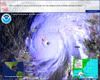
#7046 Postby kurtpage » Wed Jul 23, 2008 12:10 am

URNT15 KNHC 230506
AF304 1804A DOLLY HDOB 32 20080723
045530 2511N 09613W 6965 02978 9812 +122 +060 312037 039 036 001 00
045600 2512N 09612W 6967 02967 9808 +116 +060 309023 030 031 000 00
045630 2514N 09611W 6970 02960 9812 +111 +060 289007 010 021 000 03
045700 2515N 09610W 6966 02961 9806 +115 +060 246001 004 012 001 03
045730 2516N 09608W 6971 02958 9811 +111 +060 147009 010 015 000 00
045800 2518N 09607W 6962 02967 9814 +108 +060 155014 016 015 000 00
045830 2519N 09605W 6968 02964 9814 +110 +060 154016 018 018 000 00
045900 2520N 09604W 6968 02964 9817 +110 +060 155018 019 019 000 00
045930 2522N 09602W 6962 02971 9815 +110 +060 149019 021 021 000 00
050000 2523N 09601W 6967 02969 9817 +111 +060 150022 023 025 001 00
050030 2524N 09600W 6967 02969 9823 +108 +060 148030 035 033 001 00
050100 2526N 09558W 6963 02978 9824 +110 +060 147041 043 043 001 00
050130 2527N 09557W 6958 02991 9857 +092 +060 146047 051 063 018 00
050200 2528N 09555W 6956 02998 9876 +085 +060 145056 062 067 016 00
050230 2529N 09554W 6979 02981 9887 +085 +060 134060 060 069 013 00
050300 2531N 09553W 6969 03006 9904 +079 +060 135069 071 065 023 00
050330 2532N 09551W 6952 03033 9888 +098 +060 137071 072 064 010 00
050400 2533N 09550W 6964 03028 9880 +110 +060 139073 075 060 004 00
050430 2534N 09549W 6972 03028 9901 +102 +060 141068 071 059 002 00
050500 2535N 09547W 6967 03042 9918 +096 +060 143067 069 058 000 00
$$
;

Pressure = 981mb
75 kt FL
69 kt SFMR.
0 likes   

Ed Mahmoud

Re: Re:

#7047 Postby Ed Mahmoud » Wed Jul 23, 2008 12:10 am

Ed Mahmoud wrote:
Derek Ortt wrote:nope

Dolly continues to move to the WNW. Just did the 12 a.m. CDT outlook on nwhhc

Dolly is right on track based upon the last vortex message

Now has to move about 310 to hit the border... and its moving closer to 295


Texas' streak of over ten months without a landfalling hurricane looks to continue...


yes, I know, as far as population centers, 15 miles North of BRO would cause less damage and interruption than 15 miles South of BRO.
0 likes   

User avatar
Hurricaneman13
Tropical Low
Tropical Low
Posts: 33
Joined: Tue Jul 22, 2008 10:33 pm

Re: ATL: H Dolly in Western Gulf of Mexico

#7048 Postby Hurricaneman13 » Wed Jul 23, 2008 12:12 am

There's been no major hurricane that made landfall in the United States since Hurricane Wilma. Looking how close it is to land, it will most likely not happen IMO.
0 likes   

User avatar
Pebbles
S2K Supporter
S2K Supporter
Posts: 1994
Joined: Tue Jul 08, 2003 1:42 pm
Location: New Lenox, IL (SW of Chicago)

Re: ATL: H Dolly in Western Gulf of Mexico

#7049 Postby Pebbles » Wed Jul 23, 2008 12:12 am

I was looking at the Dvorac loop. http://www.ssd.noaa.gov/goes/flt/t2/loop-bd.html

And while I'm not going out on a limb saying it's going cat 3 or anything like this, I don't think it's done with steadly intensifying ATM. I do think we'll see the pressure continue to drop. Now IF there is enough time for that to transition over to higher winds speed with land interaction and shallower waters soon throwing a loop in the picture is another story. All I know is I have seen way to many wierd things happen during land interaction with storms to rule anything out anymore.
Last edited by Pebbles on Wed Jul 23, 2008 12:15 am, edited 1 time in total.
0 likes   

CrazyC83
Professional-Met
Professional-Met
Posts: 34002
Joined: Tue Mar 07, 2006 11:57 pm
Location: Deep South, for the first time!

#7050 Postby CrazyC83 » Wed Jul 23, 2008 12:13 am

The numbers still support 70 kt at this point.
0 likes   

User avatar
Hurricaneman13
Tropical Low
Tropical Low
Posts: 33
Joined: Tue Jul 22, 2008 10:33 pm

Re: ATL: H Dolly in Western Gulf of Mexico

#7051 Postby Hurricaneman13 » Wed Jul 23, 2008 12:16 am

We'll have to see what the 2AM advisory says.
0 likes   

CrazyC83
Professional-Met
Professional-Met
Posts: 34002
Joined: Tue Mar 07, 2006 11:57 pm
Location: Deep South, for the first time!

Re: ATL: H Dolly in Western Gulf of Mexico

#7052 Postby CrazyC83 » Wed Jul 23, 2008 12:17 am

Hurricaneman13 wrote:We'll have to see what the 2AM advisory says.


Probably no change. Pressure should remain around 980mb, the winds probably still 70 kt.
0 likes   

Derek Ortt

#7053 Postby Derek Ortt » Wed Jul 23, 2008 12:18 am

if the differences between xtrap and actual pressures hold, then the pressure may be a bit higher this time.

no sign what so ever of intensifictaion
0 likes   

User avatar
Pebbles
S2K Supporter
S2K Supporter
Posts: 1994
Joined: Tue Jul 08, 2003 1:42 pm
Location: New Lenox, IL (SW of Chicago)

Re: ATL: H Dolly in Western Gulf of Mexico

#7054 Postby Pebbles » Wed Jul 23, 2008 12:21 am

So Derek are you saying you don't think that we'll see any more pressure drops before landfall? Or your just talking atm?
0 likes   

User avatar
HouTXmetro
Category 5
Category 5
Posts: 3949
Joined: Sun Jun 13, 2004 6:00 pm
Location: District of Columbia, USA

#7055 Postby HouTXmetro » Wed Jul 23, 2008 12:22 am

Time for bed! Hopefully a Thunderstorm from an outerband will roll through Houston and awaken me in the wee hours of the morning.
0 likes   

User avatar
Hurricaneman13
Tropical Low
Tropical Low
Posts: 33
Joined: Tue Jul 22, 2008 10:33 pm

Re: ATL: H Dolly in Western Gulf of Mexico

#7056 Postby Hurricaneman13 » Wed Jul 23, 2008 12:22 am

Then, Dolly will probably make landfall with 90 mph winds like the NHC is saying. However, the NHC said something about lots of rain and flooding.
0 likes   

Derek Ortt

#7057 Postby Derek Ortt » Wed Jul 23, 2008 12:26 am

it should intensify a little more before landfall
0 likes   

User avatar
Pebbles
S2K Supporter
S2K Supporter
Posts: 1994
Joined: Tue Jul 08, 2003 1:42 pm
Location: New Lenox, IL (SW of Chicago)

Re:

#7058 Postby Pebbles » Wed Jul 23, 2008 12:27 am

Derek Ortt wrote:it should intensify a little more before landfall


Coolie.. thanks for clarifying your thoughts :)
0 likes   

User avatar
cheezyWXguy
Category 5
Category 5
Posts: 6108
Joined: Mon Feb 13, 2006 12:29 am
Location: Dallas, TX

Re:

#7059 Postby cheezyWXguy » Wed Jul 23, 2008 12:29 am

Derek Ortt wrote:it should intensify a little more before landfall

Looks like it hasnt started yet, but based on satellite presentation it might begin soon.
0 likes   

User avatar
JtSmarts
S2K Supporter
S2K Supporter
Posts: 1437
Age: 39
Joined: Thu Jul 10, 2003 1:29 pm
Location: Columbia, South Carolina

Re:

#7060 Postby JtSmarts » Wed Jul 23, 2008 12:29 am

Derek Ortt wrote:it should intensify a little more before landfall


So generally, Dolly will be a storm similar to Claudette-03 or Humberto in strength?
0 likes   


Return to “2008”

Who is online

Users browsing this forum: No registered users and 5 guests