ATL: IKE Discussion
Moderator: S2k Moderators
-
Wx_Warrior
- Category 5

- Posts: 2718
- Joined: Thu Aug 03, 2006 3:58 pm
- Location: Beaumont, TX
Re: ATL IKE: Category 1 - Discussion
It's where Cantore ends up on TV on Friday....there's the trouble site!!! 
0 likes
-
soonertwister
- Category 5
- Posts: 1091
- Joined: Mon Jun 16, 2003 2:52 pm
Re: Re:
thetruesms wrote:soonertwister wrote:Extremeweatherguy wrote:If the 11pm track is correct, then this will be a very bad storm from the Texas coast all the way up through Dallas and even into Oklahoma and beyond! We could be looking at a big wind event for cities such as Houston and Victoria, followed by an extreme rainfall and possible tornado threat for Austin, Dallas and Oklahoma City. Nasty! Nasty! Nasty!
http://www.nhc.noaa.gov/storm_graphics/ ... 15W_sm.gif
This could very well be one of the worst tropical systems to affect all of the above mentioned areas in many, many years..
I was down in the OKC area last year when TD Erin went by and died shortly thereafter. Erin was briefly a TS and weakened to a TD just before landfall. Erin traversed south Texas to the northern Panhandle and exited the Panhandle not two days before disippation. She rapidly intensified as she approached central Oklahoma however, and deluge rains, confirmed 60 mph sustained winds and wind gusts above 80 hit the OKC metro area overnight.
My mom's 6" rain gauge was emptied before Erin arrived, and sometime between midnight and 6 am overtopped, and we weren't near the most intense part of the storm. In spite of the strong tropical storm force winds, the NHC refused to say that Erin had reintensified into a TS, instead calling it a "low" despite the fact that their own track shows the storm clearly passing the OKC area before dissipation. The winds weren't much of a deal in Oklahoma, but six people drowned because of Erin, with another 10 dead in Texas.
I mention this because Ike is forecast to run right over OKC Sunday evening, and this is no namby-pamby storm. I remember the huge rains we received when Carla came through northeastern OK, and it was pretty intense. And it took several days for Carla to get there, not like the two days that they are forecasting for Ike.
I mentioned the TS intensity of Erin because I think the NHC erred in not saying that she reintensified over land. At wikipedia you can search for Erin Oklahoma City, and the web page on that storm has a nice radar image of an eyewall and clearly defined rainbands as she passed just north of OKC.
We had two tornado warnings that overnight, among many for the metro area.
That was not a fun morning, taking my dog out - though it did make me think to check a radar image, so I could see her "eye". Though from reading the NHC TC Report, it wasn't a mistake to refrain from calling it a TS. The causes for it reintensifying weren't tropical in nature - perhaps it could have been labeled subtropical if it had lasted a little longer.
It might be kind of fun to see that happen again, but from the model runs so far, I don't think we'll be getting that pleasure from Ike . . . just a lot of rain. Though at this time of year, that would be pretty welcome . . . except in the northeastern part of the state, of course.
I think the worst scenario would be a stall-out in NE OK or around the KS-OK-AR-MO border area. The flooding in either of those areas could be disastrous, although I don't think that Tulsa proper is likely to get hit really bad. If anyone has a flood abatement system more advanced than Tulsa's, I haven't heard of it yet.
0 likes
-
jlauderdal
- S2K Supporter

- Posts: 7240
- Joined: Wed May 19, 2004 5:46 am
- Location: NE Fort Lauderdale
- Contact:
Re: ATL IKE: Category 1 - Discussion
Matt-hurricanewatcher wrote:A Typhoon Tips could never form in the gulf. It would be bigger then the gulf...The biggest Atlatnic cyclones have about 300 nmi wide tropical storm wind field, Tips had 3 times that.
Do I think this could get to have a wind field the size of Katrina, Wilma, it may not be impossible.
typhoon tip was the bomb, i dont think there is enough space or energy to ever generate anything the size of tip in the Atlantic basin, that system was legendary for good reason and lets keep it that way
0 likes
-
HouTXmetro

- Category 5
- Posts: 3949
- Joined: Sun Jun 13, 2004 6:00 pm
- Location: District of Columbia, USA

-
Stormcenter
- S2K Supporter
- Posts: 6689
- Joined: Wed Sep 03, 2003 11:27 am
- Location: Houston, TX
Re:
HouTXmetro wrote:I'm about to retire until the EURO comes out... one observation, not gaining much latitude right now.
Do you mean it's moving more westward?
0 likes


Re: ATL IKE: Category 1 - Discussion
Looking at that Key West radar, I was struck by just how much rain there was in this system. All of that is headed for the Upper Texas/Louisiana coasts...
0 likes
-
belltowner
- Tropical Wave

- Posts: 2
- Joined: Sat Aug 30, 2008 2:06 pm
- Location: Seattle, WA
Photos from Cuba
Many pictures of the damage in Cuba (including the ones someone else posted from Barbacoa) on photographer maikellevy's Flickr pages.
IKE
http://www.flickr.com/photos/30166603@N ... 180421613/
GUSTAV
http://www.flickr.com/photos/30166603@N ... 086826272/
(Apologies in advance if someone beat me to it.)
IKE
http://www.flickr.com/photos/30166603@N ... 180421613/
GUSTAV
http://www.flickr.com/photos/30166603@N ... 086826272/
(Apologies in advance if someone beat me to it.)
0 likes
-
MHurricanes

- Tropical Storm

- Posts: 102
- Age: 74
- Joined: Thu Aug 14, 2008 2:05 pm
- Location: Altamonte Springs, FL
- Contact:
Re: ATL IKE: Category 1 - Discussion
jlauderdal wrote:Matt-hurricanewatcher wrote:A Typhoon Tips could never form in the gulf. It would be bigger then the gulf...The biggest Atlatnic cyclones have about 300 nmi wide tropical storm wind field, Tips had 3 times that.
Do I think this could get to have a wind field the size of Katrina, Wilma, it may not be impossible.
typhoon tip was the bomb, i dont think there is enough space or energy to ever generate anything the size of tip in the Atlantic basin, that system was legendary for good reason and lets keep it that way
Here is Typhoon Tip and other notable hurricanes:
http://www.srh.noaa.gov/jetstream/tropics/tc_notable.htm
0 likes

Re: ATL IKE: Category 1 - Discussion
Viper54r wrote:What time can we expect the Euro?
2am CDT
0 likes


Re: ATL IKE: Category 1 - Discussion
Hurricane Gilbert was one of the largest hurricanes seen in the Atlantic. However, Tip was MUCH larger than Gilbert. Here is a thread I created for Tip.
viewtopic.php?f=31&t=100334
viewtopic.php?f=31&t=100334
Last edited by Ptarmigan on Wed Sep 10, 2008 12:34 am, edited 1 time in total.
0 likes
-
MHurricanes
- Tropical Storm
- Posts: 102
- Age: 74
- Joined: Thu Aug 14, 2008 2:05 pm
- Location: Altamonte Springs, FL
- Contact:
Re: ATL IKE: Category 1 - Discussion
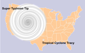
Relative size of super typhoon Tip compared to U.S.
http://upload.wikimedia.org/wikipedia/commons/4/4e/Typhoonsizes.jpg
http://upload.wikimedia.org/wikipedia/commons/4/4e/Typhoonsizes.jpg
0 likes
-
Hurricanewatcher2007

- Category 2

- Posts: 578
- Joined: Sat Jul 05, 2008 8:10 pm
Re: ATL IKE: Category 1 - Discussion
Recon is finding 50 and 60kts winds WELL away from the center. I really didn't expect them to already be finding that strong of winds where they currently are!
0 likes
-
bob rulz
- Category 5
- Posts: 1711
- Age: 36
- Joined: Sat Jan 28, 2006 7:30 pm
- Location: Salt Lake City, Utah
Re: ATL IKE: Category 1 - Discussion
MHurricanes wrote:Relative size of super typhoon Tip compared to U.S.
http://upload.wikimedia.org/wikipedia/commons/4/4e/Typhoonsizes.jpg
It's a good thing that it's essentially impossible for that thing to bear down on the East Coast.
0 likes
-
thetruesms

- Professional-Met

- Posts: 844
- Age: 42
- Joined: Thu Aug 16, 2007 1:14 pm
- Location: Tallahasee, FL
- Contact:
Re: ATL IKE: Category 1 - Discussion
Yeah, there are certain things that can go down in the Pacific that just can't happen in the Atlantic, and that's definitely one of thembob rulz wrote:MHurricanes wrote:Relative size of super typhoon Tip compared to U.S.
http://upload.wikimedia.org/wikipedia/commons/4/4e/Typhoonsizes.jpg
It's a good thing that it's essentially impossible for that thing to bear down on the East Coast.

0 likes
-
Hurricanewatcher2007
- Category 2
- Posts: 578
- Joined: Sat Jul 05, 2008 8:10 pm
Re: ATL IKE: Category 1 - Discussion
** Puts on moderators hat **
Ok don't want to be rude or anything but this thread is getting completely off topic! This is not a thread to talk about Typhoon Tip! If you want to talk about Tip then please visit this thread:
viewtopic.php?f=31&t=100334&p=1696591
This thread is for Ike not Tip so please stay on topic!
** Takes off moderators hat **
Now recon might be finding evidence of a double wind maxima or it could just be that they are flying through an area of lighter convection at the moment. It will be interesting to see what the VDM says about a possible Eye wall replacement cycle!
0 likes

Re: ATL IKE: Category 1 - Discussion
Low-res (but non-eclipsed) satellite:
http://www.nrlmry.navy.mil/tcdat/tc08/ATL/09L.IKE/ir/geo/1km/20080910.0430.goes11.x.ir1km.09LIKE.65kts-970mb-227N-834W.100pc.jpg
http://www.nrlmry.navy.mil/tcdat/tc08/ATL/09L.IKE/ir/geo/1km/20080910.0500.goes11.x.ir1km.09LIKE.65kts-970mb-227N-834W.100pc.jpg
http://www.nrlmry.navy.mil/tcdat/tc08/ATL/09L.IKE/ir/geo/1km/20080910.0530.goes11.x.ir1km.09LIKE.65kts-970mb-227N-834W.100pc.jpg
Still looks like its steadily building, though eye has closed over (possible ERC underway?). Really doesn't look like its moving much, and Cuba's still copping it.
Last edited by commuter on Wed Sep 10, 2008 1:06 am, edited 1 time in total.
0 likes
-
Houstonia

- S2K Supporter
- Posts: 829
- Age: 61
- Joined: Fri Oct 11, 2002 9:45 am
- Location: Sharpstown, Houston, Harris County, Southeast Texas.
Re: ATL IKE: Category 1 - Discussion
Dang, that's one big storm... even if it comes in at Matagorda - it seems Houstonians are in for a lot of wind and rain...
http://icons-pe.wunderground.com/data/456x343/2xat_ir.gif?2008910204
http://icons-pe.wunderground.com/data/456x343/2xat_ir.gif?2008910204
0 likes
Who is online
Users browsing this forum: No registered users and 19 guests