ATL: Tropical Depression Dolly
Moderator: S2k Moderators


-
paintplaye
- Category 1

- Posts: 380
- Joined: Sun Jul 20, 2008 11:25 pm
Re: Re:
americanrebel wrote:KWT wrote:Well the models were expecting the high opressure to build back in and force the system on a westerly track ,its just a matter of when that actually happens.
So what is the High doing now, still retreating East?
I expect it to be building back but it just hasn't effected it yet.
On another note Houston is fixing to get hit with pretty healthy storms.
0 likes
-
paintplaye
- Category 1
- Posts: 380
- Joined: Sun Jul 20, 2008 11:25 pm
Re:
KWT wrote:Well the models hav been expecting it, we will see it when you can see the system heading west.
Yea, how much would it suck if they failed us now; when it really mattered.
0 likes


Re: ATL: H Dolly in Western Gulf of Mexico
Normandy, KWT...
RE: right front quadrant...
Keep in mind that our understanding of the right front quadrant being more severe is dependent on forward speed and proximity of a surface pressure high. There are other factors which may lessen this effect. As such, Dolly is not really moving fast enough for this to be a significant impact on wind velocity. With this in mind, Brownsville will likely get similar wind speed from any quadrant of the eye wall. 5-8mph difference based on forward speed isn't going to make much difference. Brownsville wants to avoid any part of it, if possible.
On the other hand, the right front quadrant will always certainly be significant with respect to storm surge -- for obvious reasons due to onshore flow vs offshore flow at landfall.
0 likes
-
JonathanBelles
- Professional-Met

- Posts: 11430
- Age: 35
- Joined: Sat Dec 24, 2005 9:00 pm
- Location: School: Florida State University (Tallahassee, FL) Home: St. Petersburg, Florida
- Contact:


Re: Re:
paintplaye wrote:
On another note Houston is fixing to get hit with pretty healthy storms.
Yep Houston is fixing to get dumped on! I'm wondering if what's to the southeast of that Houston batch will make it to me (Orange County) or will it head to my west? It looks pretty healthy spinning up from Dolly.
0 likes
-
americanrebel
Re: ATL: H Dolly in Western Gulf of Mexico
http://www.weather.com/weather/map/7051 ... _plus_usen
Looking at this looks like the eye hasn't moved or moved mostly due N.
Looking at this looks like the eye hasn't moved or moved mostly due N.
0 likes
-
paintplaye
- Category 1
- Posts: 380
- Joined: Sun Jul 20, 2008 11:25 pm
Re: Re:
Diva wrote:paintplaye wrote:
On another note Houston is fixing to get hit with pretty healthy storms.
Yep Houston is fixing to get dumped on! I'm wondering if what's to the southeast of that Houston batch will make it to me (Orange County) or will it head to my west? It looks pretty healthy spinning up from Dolly.
Yes and what i am afraid of is training effects. With tropical moisture, that IS NEVER GOOD! Plus with Allison still on peoples minds anytime they hear training they freak out.
0 likes

Re: ATL: H Dolly in Western Gulf of Mexico
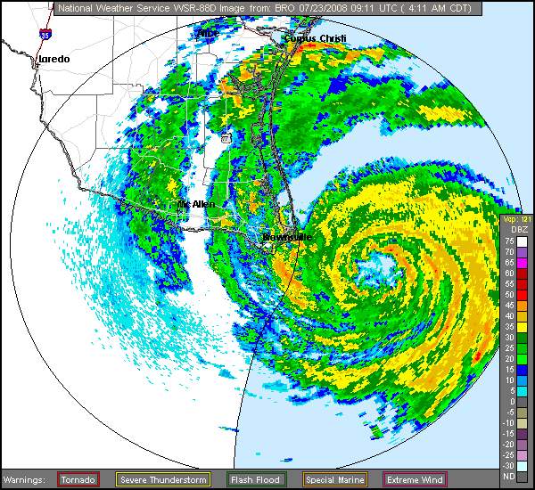
It may be very early in the morning, but Dolly's eye looks star-shaped in the last few frames of the NWS BRO radar loop.
0 likes


Re: ATL: H Dolly in Western Gulf of Mexico
Yes the star shape is due to many meso storms rotating around the center of Dolly.
0 likes
Who is online
Users browsing this forum: No registered users and 76 guests