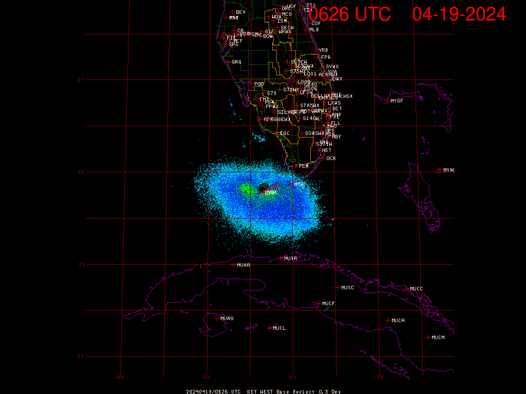
ATL GUSTAV: Tropical Depression - Discussion

Moderator: S2k Moderators

Message
Author
BigB0882
S2K Supporter
S2K Supporter
Posts: 2284
Joined: Thu Jul 03, 2003 12:08 am
Location: Baton Rouge, LA
Contact:

Re: Cat. 4 Hurricane Gustav in NW Caribbean Sea

#7261 Postby BigB0882 » Sat Aug 30, 2008 5:30 pm

GoneBabyGone wrote:
GoneBabyGone wrote:I'm located in Baton Rouge (LSU). Not a hurricane expert by any means. What's it looking like for me? Should I get the hell out of dodge? Or should I be pretty safe here?


I am in Baton Rouge as well but can't answer this accurately. I will say I did see some met say that if the track verifies that BR could expect gusts of 90-100 MPH. It is all dependent on landfall and intensity. Expect very high winds, I would say high tropical storm sustained as of now unless the track changes drastically.
0 likes   

User avatar
Innotech
Category 5
Category 5
Posts: 1031
Joined: Mon Aug 30, 2004 5:32 pm
Location: Lafayette, Louisiana
Contact:

Re: Cat. 4 Hurricane Gustav in NW Caribbean Sea

#7262 Postby Innotech » Sat Aug 30, 2008 5:31 pm

GoneBabyGone wrote:
GoneBabyGone wrote:I'm located in Baton Rouge (LSU). Not a hurricane expert by any means. What's it looking like for me? Should I get the hell out of dodge? Or should I be pretty safe here?

you are far enough northeast that you shouldnt sustain heavy damage. It will be plenty windy though.
Myself, not so lucky. possibly 90-100 mph winds here in Lafayette I reckon. We are ready for it though.
0 likes   

User avatar
KWT
Category 5
Category 5
Posts: 31415
Joined: Tue Aug 17, 2004 11:02 am
Location: UK!!!

#7263 Postby KWT » Sat Aug 30, 2008 5:32 pm

yeah besides the pressure will probably fall yet further when this does get into the gulf.

I see no reason why this isn't a cat-5 by 9hrs time providing the eye doesn't take too long to clear out the shallow layer of cloud cover thats developed whilst its overland.
0 likes   

CrazyC83
Professional-Met
Professional-Met
Posts: 34093
Joined: Tue Mar 07, 2006 11:57 pm
Location: Deep South, for the first time!

Re: Cat. 4 Hurricane Gustav in NW Caribbean Sea

#7264 Postby CrazyC83 » Sat Aug 30, 2008 5:32 pm

GoneBabyGone wrote:Sadly enough, Baton Rouge local authorities haven't said much. Everyone is so focused on New Orleans that those of us further inland are kind of forgotten.


Not to mention those east and west of New Orleans (especially west where the threat, if anything, is even greater).
0 likes   

User avatar
TampaFl
S2K Supporter
S2K Supporter
Posts: 1904
Age: 67
Joined: Thu Sep 04, 2003 11:23 am
Location: Tampa, FL

Re:

#7265 Postby TampaFl » Sat Aug 30, 2008 5:33 pm

KWT wrote:Its still running to the east of the track indeed, current imagery suggests the NHC are both too slow and also about 30 miles too far west even with a wobble back.

The track does look like its going to have to be adjusted eastwards a touch, esp if this continues.


SFWMD - Key West radar shows moving just east of the forecasted track.

http://my.sfwmd.gov/sfwmd/common/images/weather/noaaport/radar_byx2_anim.gif
0 likes   

GoneBabyGone
Tropical Storm
Tropical Storm
Posts: 101
Joined: Sat Aug 30, 2008 4:28 pm

Re: Cat. 4 Hurricane Gustav in NW Caribbean Sea

#7266 Postby GoneBabyGone » Sat Aug 30, 2008 5:34 pm

CrazyC83 wrote:
GoneBabyGone wrote:Sadly enough, Baton Rouge local authorities haven't said much. Everyone is so focused on New Orleans that those of us further inland are kind of forgotten.


Not to mention those east and west of New Orleans (especially west where the threat, if anything, is even greater).


Friend of mine in Houma is panicking (and rightfully so). But they seem to be afterthoughts to authorities and media.
0 likes   

User avatar
HURAKAN
Professional-Met
Professional-Met
Posts: 46086
Age: 38
Joined: Thu May 20, 2004 4:34 pm
Location: Key West, FL
Contact:

#7267 Postby HURAKAN » Sat Aug 30, 2008 5:36 pm

Image
0 likes   

User avatar
KWT
Category 5
Category 5
Posts: 31415
Joined: Tue Aug 17, 2004 11:02 am
Location: UK!!!

#7268 Postby KWT » Sat Aug 30, 2008 5:36 pm

Well yeah the threat is probably greater to the west of N.O.

The thing is this is a pretty large hurricane so those even a little away from the center will likely get hurricane force gusts I feel.
0 likes   

User avatar
Cyclenall
Category 5
Category 5
Posts: 6667
Joined: Thu Jun 08, 2006 10:01 pm
Location: Ontario, Canada

#7269 Postby Cyclenall » Sat Aug 30, 2008 5:38 pm

This is wild, I had to stay up all night to watch it explosively strengthen and now it's a strong category 4 hurricane heading for the Gulf coast. Those who said this has a 0% of becoming a category 5 hurricane, now look.

The models showing a category 4 south of Cuba have turned out to be correct.
0 likes   

jinftl
Category 5
Category 5
Posts: 4312
Joined: Tue Aug 31, 2004 4:47 pm
Location: fort lauderdale, fl

Re: Cat. 4 Hurricane Gustav in NW Caribbean Sea

#7270 Postby jinftl » Sat Aug 30, 2008 5:39 pm

You are not in a storm surge zone, so you will probably be ok......but if you live in a structure like a mobile home, or your area is prone to flooding from excessive rain, or anything like that....go!

Gusts 75 mph or so will knock power out and knock down trees, but shouldn't do real structural damage. Obviously that changes if your expected winds go up.

In reality, evacuate only if you have to....and that is your call...by all means err on the side of caution and peace of mind....but it is even a bigger mess when those who don't need to leave tie up the roads for those who really do need to evacuate and will be coming inland from the coast.

GoneBabyGone wrote:I'm located in Baton Rouge (LSU). Not a hurricane expert by any means. What's it looking like for me? Should I get the hell out of dodge? Or should I be pretty safe here?
0 likes   

User avatar
KWT
Category 5
Category 5
Posts: 31415
Joined: Tue Aug 17, 2004 11:02 am
Location: UK!!!

#7271 Postby KWT » Sat Aug 30, 2008 5:39 pm

Hurakan, yep Gustav is to thje east of that track, even now its still not passed the longitutde of the Isle of youth totally and its nearly half inland.
0 likes   

User avatar
HURAKAN
Professional-Met
Professional-Met
Posts: 46086
Age: 38
Joined: Thu May 20, 2004 4:34 pm
Location: Key West, FL
Contact:

#7272 Postby HURAKAN » Sat Aug 30, 2008 5:39 pm

Image

Center is inland.
0 likes   

User avatar
x-y-no
Category 5
Category 5
Posts: 8359
Age: 65
Joined: Wed Aug 11, 2004 12:14 pm
Location: Fort Lauderdale, FL

#7273 Postby x-y-no » Sat Aug 30, 2008 5:40 pm

I know this is trivial but listening to all the news reports I'm hearing every reporter badly mispronounce the name Gustav. It's accent on the first syllable, short "u", long "a" and voiced "v" -

gu' stav - not goo stof ...
0 likes   

User avatar
PTPatrick
Category 5
Category 5
Posts: 1831
Joined: Sat Jun 12, 2004 8:38 am

Re: Cat. 4 Hurricane Gustav in NW Caribbean Sea

#7274 Postby PTPatrick » Sat Aug 30, 2008 5:40 pm

18 z UKMET landfall PLaquemines/Lafourche! Thats like 40 miles east of the previous....
http://moe.met.fsu.edu/cgi-bin/ukmtc2.c ... =Animation


The 500 mb looks like the front is a little faster or the high is a bit further east...either way....means a big difference I would think for MS and NOLA.
Last edited by PTPatrick on Sat Aug 30, 2008 5:43 pm, edited 1 time in total.
0 likes   

User avatar
KWT
Category 5
Category 5
Posts: 31415
Joined: Tue Aug 17, 2004 11:02 am
Location: UK!!!

Re:

#7275 Postby KWT » Sat Aug 30, 2008 5:41 pm

Cyclenall wrote:This is wild, I had to stay up all night to watch it explosively strengthen and now it's a strong category 4 hurricane heading for the Gulf coast. Those who said this has a 0% of becoming a category 5 hurricane, now look.

The models showing a category 4 south of Cuba have turned out to be correct.


It was pretty obvious once it had a good core that it'd probably bomb, its gone over the highest heat content in the basin and got close to the cusp of cat-5, its still got the loop current to go over and so got another 18hrs probably before heat content decreases, plenty of time for further bombing to cat-5.
0 likes   

Nexus
Tropical Storm
Tropical Storm
Posts: 137
Joined: Sat Sep 11, 2004 12:13 am

#7276 Postby Nexus » Sat Aug 30, 2008 5:44 pm

One of the last Vis for today:

Image
0 likes   

tolakram
Admin
Admin
Posts: 20036
Age: 62
Joined: Sun Aug 27, 2006 8:23 pm
Location: Florence, KY (name is Mark)

Re: Re:

#7277 Postby tolakram » Sat Aug 30, 2008 5:44 pm

TampaFl wrote:
KWT wrote:Its still running to the east of the track indeed, current imagery suggests the NHC are both too slow and also about 30 miles too far west even with a wobble back.

The track does look like its going to have to be adjusted eastwards a touch, esp if this continues.


SFWMD - Key West radar shows moving just east of the forecasted track.

http://my.sfwmd.gov/sfwmd/common/images/weather/noaaport/radar_byx2_anim.gif


Now that is a wobble and darn close to the track. It's headed back west now.

Edit: ha, I see they shifted the track east, my bad ... yea, still running NE of track.
Last edited by tolakram on Sat Aug 30, 2008 5:46 pm, edited 1 time in total.
0 likes   

User avatar
HURAKAN
Professional-Met
Professional-Met
Posts: 46086
Age: 38
Joined: Thu May 20, 2004 4:34 pm
Location: Key West, FL
Contact:

#7278 Postby HURAKAN » Sat Aug 30, 2008 5:46 pm

Image
0 likes   

soonertwister
Category 5
Category 5
Posts: 1091
Joined: Mon Jun 16, 2003 2:52 pm

Re:

#7279 Postby soonertwister » Sat Aug 30, 2008 5:48 pm

HURAKAN wrote:Image


Do you see the face peering out from the eye? It's clear as can be...
0 likes   

User avatar
KWT
Category 5
Category 5
Posts: 31415
Joined: Tue Aug 17, 2004 11:02 am
Location: UK!!!

#7280 Postby KWT » Sat Aug 30, 2008 5:48 pm

Still got decent shape Nexus, wouldn't think that stuff in the eye would take long to clear out given how shallow it seems to be.

Eye decently inland, should be back into the water in about 3hrs or so.
0 likes   


Return to “2008”

Who is online

Users browsing this forum: No registered users and 3 guests