ATL: IKE Discussion

Moderator: S2k Moderators

Message
Author
Air Force Met
Military Met
Military Met
Posts: 4372
Age: 56
Joined: Tue Jul 08, 2003 9:30 am
Location: Roan Mountain, TN

Re: ATL IKE: Category 1 - Discussion

#7521 Postby Air Force Met » Wed Sep 10, 2008 11:56 am

dwg71 wrote:
ronjon wrote:11am NHC track at LF looks to have shifted northward by about 60-80 miles looking at the forecast advisory - 28.5N-97W. Intensity forecast at 105 kts (120 mph). Movement stationary the last three hours.


Like my buddy AFM said, dont focus on the line, it still on the exact path as prior update, overlay the two graphics, if the NHC used a curved line then you could see it better, if they dont change track reasoning at 4PM, it will appear to move south because they are just extrapolating the points based on the track. The hurricane does not go from point to point, especially around the periphery of a ridge, it will curve.

It did not move land fall point at all.


I have said that before...but not about this track. That is a certain shift north...by 50 miles.
0 likes   

User avatar
thetruesms
Professional-Met
Professional-Met
Posts: 844
Age: 41
Joined: Thu Aug 16, 2007 1:14 pm
Location: Tallahasee, FL
Contact:

Re: ATL IKE: Category 1 - Discussion

#7522 Postby thetruesms » Wed Sep 10, 2008 11:57 am

hriverajr wrote:I am not much of a tropical meterologist, but just a few things I have observed. As it has been pointed out, where Ike goes depends on the strength of the ridge as well as how fast and how deep the trough to the west is. It is a very difficult forecast. It appears that a cut off low may be forming in California, What effect that energy hanging back, and its effect on the overall trough, is really unknown at this time. One could speculate that it could result in a more westward path, but at the same time Ike seems to be moving slower, which could argue for a turn to the north earlier. That may be why the NHC is going right down the middle, A lot of the models are clustered there, not withstanding some of the Global Models. All in all a very very difficult forecast and I honestly believe we might not know until, Ike starts turning.

Hector
I agree completely. The more I look at this, the less of a grasp I feel like I have on it :lol: There do seem to be some competing interests here - it does look very much like a cut-off is forming over California, which would bring up thoughts of a more westward track. Ike moving more slowly, though, seems to counter that threat, at least to me. And while the weakness to the north of Ike does seem to be building in, it's not happening as quickly as I would have expected. For a forecast that seemed like it would become (relatively) straightforward a day or two ago, it seems to be getting more difficult than first anticipated.
0 likes   

User avatar
artist
Category 5
Category 5
Posts: 9792
Joined: Mon Jun 06, 2005 3:26 pm
Location: West Palm

Re: ATL IKE: Category 1 - Discussion

#7523 Postby artist » Wed Sep 10, 2008 11:58 am

hriverajr wrote:I am not much of a tropical meteorologist, but just a few things I have observed. As it has been pointed out, where Ike goes depends on the strength of the ridge as well as how fast and how deep the trough to the west is. It is a very difficult forecast. It appears that a cut off low may be forming in California, What effect that energy hanging back, and its effect on the overall trough, is really unknown at this time. One could speculate that it could result in a more westward path, but at the same time Ike seems to be moving slower, which could argue for a turn to the north earlier. That may be why the NHC is going right down the middle, A lot of the models are clustered there, not withstanding some of the Global Models. All in all a very very difficult forecast and I honestly believe we might not know until, Ike starts turning.

Hector


thanks for that information. It just goes to show how complex these forecasts can be. Fortunately they aren't all quite this complex. But this added change just makes this one that much harderwhere it was already very complex.
0 likes   

dwg71
Category 5
Category 5
Posts: 2349
Joined: Wed Jun 08, 2005 4:34 pm

#7524 Postby dwg71 » Wed Sep 10, 2008 12:00 pm

actually if its really slower and the low cuts off, it allows High over SE US to build back in and could lead to a more west track. If trough comes in in tact, then a slower path would mean more north.

Not sure how Houston Galv could be in play, but not SW LA.
0 likes   

User avatar
Pebbles
S2K Supporter
S2K Supporter
Posts: 1994
Joined: Tue Jul 08, 2003 1:42 pm
Location: New Lenox, IL (SW of Chicago)

Re: ATL IKE: Category 1 - Discussion

#7525 Postby Pebbles » Wed Sep 10, 2008 12:00 pm

inda_iwall wrote:If anything you just proved my point, that we always need to be on guard and open to possibilities, everyone gets so locked in on models and pro mets and maps, that sometimes things change and have their own minds when it comes to mother nature. I am in no way "BASHING", just questioning, I think sometimes scientists get so locked into analyzing data objectively, they lose sight that this is mother nature. Things can change, we can not predict everything. I am just striking back I guess because I am going against the mainstream thought, and I wanted to defend myself. I also think the dry air is going to inhibit RI, or any intensification past a cat 2, and I am sure you will slam me for that.

I have no problem coming back here and admitting I am wrong, I have been happily married for a while so doing that is nothing new to me in the least bit.


No no slamming for having a different thoughts from this quarter. And I apologize for coming down on you so hard... but my previous post wasn't purely directed at you but more so at several others who I've seen will sometimes flat out argue and slam those with higher education in the weather industry, while thinking they know more. I may have wrongly assumed that's what you were doing in hind sight, only because I've seen that getting to be a worse and worse problem.

Unfortunately, reading the intent of posts are sometimes difficult... BTW you don't have to 'defend yourself' just use data to explain WHY you think what you think in a constrictive manner. If you do this without bashing anyone else's forcasts and in a contructive matter, then you've every right to ignore anyone who tries bashing you (they shouldn't be... too much of that going on).

So you think dry air to the (I'm assuming to the west?) will inhibit RI and limit the storm to cat 2... we'll have to wait and how it plays out. ;P
0 likes   

User avatar
Sabanic
Category 2
Category 2
Posts: 683
Age: 65
Joined: Wed Aug 01, 2007 7:01 am
Location: Mobile, AL
Contact:

Re:

#7526 Postby Sabanic » Wed Sep 10, 2008 12:01 pm

dwg71 wrote:actually if its really slower and the low cuts off, it allows High over SE US to build back in and could lead to a more west track. If trough comes in in tact, then a slower path would mean more north.

Not sure how Houston Galv could be in play, but not SW LA.


Thought it was all set in stone ?
0 likes   

tolakram
Admin
Admin
Posts: 20012
Age: 62
Joined: Sun Aug 27, 2006 8:23 pm
Location: Florence, KY (name is Mark)

Re: ATL IKE: Category 1 - Discussion

#7527 Postby tolakram » Wed Sep 10, 2008 12:02 pm

Image
0 likes   

Stratosphere747
Category 5
Category 5
Posts: 3772
Joined: Thu Sep 11, 2003 8:34 pm
Location: Surfside Beach/Freeport Tx
Contact:

Re:

#7528 Postby Stratosphere747 » Wed Sep 10, 2008 12:02 pm

dwg71 wrote:actually if its really slower and the low cuts off, it allows High over SE US to build back in and could lead to a more west track. If trough comes in in tact, then a slower path would mean more north.

Not sure how Houston Galv could be in play, but not SW LA.


What do you mean you're not sure?

It's quite evident how they could be in play.
0 likes   

Disturbed
Tropical Wave
Tropical Wave
Posts: 3
Age: 56
Joined: Fri Aug 29, 2008 3:53 pm
Location: Hardin County, Texas

Re: ATL IKE: Category 1 - Discussion

#7529 Postby Disturbed » Wed Sep 10, 2008 12:02 pm

Evac3 wrote:It's starting to worry me (like some of you have said) that evacuations haven't been called yet here in SETX or in Galveston. I KNOW that if we (Southeast Texas) would not have had an evacuation last week, they would have already called it. They didn't hesitate to call the one for Gustav. As for now, it would seem if they do call for one, it would be for tomorrow morning, which wouldn't give everybody in Galveston, Houston, SETX, and SWLA enough time to all get out at once (unless it slows more.) And yes, you'd think we could just make our own personal decision to leave without being told to do so, but there are so many employers who threaten to fire any employee who leaves before mandatory is called. They are gambling with people's lives. Yes, it's very costly and it is definitely hard on those poor special needs people who, for some, don't have a choice in the matter... but as far as the general public is concerned, they can call for a mandatory so employees can leave if they need to... if they choose to stay, they can still choose to. They need to go ahead and call one asap to free those that want to leave. We all saw and will never forget what happened with Rita.

On another note, I've passed at least six houses here the past few days where they were cutting the rest of their trees down from around the house (the few actually left after Rita). There are no lines at the gas stations and people are just going about their dailies.

And... is this slowing still going to make a more upper Texas landfall possible? Or has something changed?


I agree. To me, this is Rita all over again. Waiting till the last minute to make the call. I just hope that the people grumbling about not leaving this time cause they can't afford due to the Gustav evac have a severe change of heart.
0 likes   

User avatar
KWT
Category 5
Category 5
Posts: 31415
Joined: Tue Aug 17, 2004 11:02 am
Location: UK!!!

#7530 Postby KWT » Wed Sep 10, 2008 12:04 pm

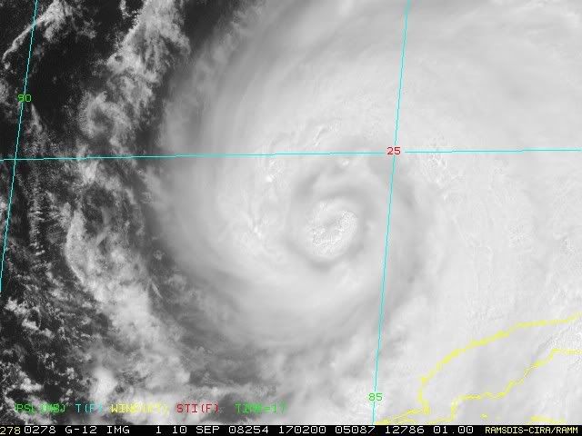
Some new convection going up in the southern eyewall once again, looks like the inner eyewall isn't going to weaken any time soon, next recon will be very interesting to observe to see what sort of state the inner eyewall is in.
0 likes   

Senobia
Category 1
Category 1
Posts: 278
Joined: Sat Aug 05, 2006 2:59 pm
Location: Somewhere over the rainbow

Re: ATL IKE: Category 1 - Discussion

#7531 Postby Senobia » Wed Sep 10, 2008 12:05 pm

[quote="Disturbed] I just hope that the people grumbling about not leaving this time cause they can't afford due to the Gustav evac have a severe change of heart.[/quote]

Or finances.
0 likes   

User avatar
funster
Category 3
Category 3
Posts: 817
Joined: Sat Dec 29, 2007 4:27 pm
Location: North Dallas

#7532 Postby funster » Wed Sep 10, 2008 12:06 pm

The deep convection is gone (for now) but Ike keeps getting larger. Even if this makes landfall as only a Cat 1 or Cat 2 it is still going to be a big problem for Texas because like Katrina it is enormous.
http://www.ssd.noaa.gov/goes/flt/t4/loop-avn.html
0 likes   

THead
S2K Supporter
S2K Supporter
Posts: 790
Joined: Mon Aug 30, 2004 5:09 pm
Location: Lauderhill, Fla./Jefferson, Ga.

Re:

#7533 Postby THead » Wed Sep 10, 2008 12:06 pm

KWT wrote:The problem is that dry air is classic moating there, it seems right now it has major structual issues, until it sorts itself out in that way Ike won't get much stronger then it is now.


Its amazing how yesterday everyone thought conditions would be perfect for fairly rapid intensification, with no shear and plenty of moist air from Lowell (saw a few ppl post on the moist/dry air issue)......and today we have both shear and dry air!! Good news for now, but also notice that the NHC raised the 48 hour intensity at 11am from 105 to 110 kts.

48HR VT 12/1200Z 26.3N 93.1W 110 KT
0 likes   

tolakram
Admin
Admin
Posts: 20012
Age: 62
Joined: Sun Aug 27, 2006 8:23 pm
Location: Florence, KY (name is Mark)

Re: ATL IKE: Category 1 - Discussion

#7534 Postby tolakram » Wed Sep 10, 2008 12:06 pm

New eye wall?

Image

Image
0 likes   

Stormcenter
S2K Supporter
S2K Supporter
Posts: 6684
Joined: Wed Sep 03, 2003 11:27 am
Location: Houston, TX

#7535 Postby Stormcenter » Wed Sep 10, 2008 12:07 pm

I hope this puts to rest the stationary,N or NE movement talk for at least the next hour or so. The latest sat. loop shows a definite westward shift.

http://www.ssd.noaa.gov/goes/east/gmex/loop-vis.html
0 likes   

rtd2
Category 5
Category 5
Posts: 1183
Joined: Tue Aug 12, 2003 12:45 pm
Location: Biloxi, MS

Re: ATL IKE: Category 1 - Discussion

#7536 Postby rtd2 » Wed Sep 10, 2008 12:08 pm

I just hope that the people grumbling about not leaving this time cause they can't afford due to the Gustav evac have a severe change of heart.

Or finances.


keep your receipts for reimbursement :wink:

http://news.yahoo.com/s/ap/20080904/ap_ ... tav_fema_1
Last edited by rtd2 on Wed Sep 10, 2008 12:11 pm, edited 1 time in total.
0 likes   

User avatar
Sabanic
Category 2
Category 2
Posts: 683
Age: 65
Joined: Wed Aug 01, 2007 7:01 am
Location: Mobile, AL
Contact:

Re:

#7537 Postby Sabanic » Wed Sep 10, 2008 12:09 pm

Stormcenter wrote:I hope this puts to rest the stationary,N or NE movement talk for at least the next hour or so. The latest sat. loop shows a definite westward shift.

http://www.ssd.noaa.gov/goes/east/gmex/loop-vis.html


You got it Brother
0 likes   

BigB0882
S2K Supporter
S2K Supporter
Posts: 2284
Joined: Thu Jul 03, 2003 12:08 am
Location: Baton Rouge, LA
Contact:

Re:

#7538 Postby BigB0882 » Wed Sep 10, 2008 12:11 pm

Stormcenter wrote:I hope this puts to rest the stationary,N or NE movement talk for at least the next hour or so. The latest sat. loop shows a definite westward shift.

http://www.ssd.noaa.gov/goes/east/gmex/loop-vis.html


I don't see anything that certain. I see it going north, then I watch and surely its going west, then I just give up... :lol:
0 likes   

User avatar
HURAKAN
Professional-Met
Professional-Met
Posts: 46086
Age: 38
Joined: Thu May 20, 2004 4:34 pm
Location: Key West, FL
Contact:

#7539 Postby HURAKAN » Wed Sep 10, 2008 12:11 pm

Image
0 likes   

dwg71
Category 5
Category 5
Posts: 2349
Joined: Wed Jun 08, 2005 4:34 pm

#7540 Postby dwg71 » Wed Sep 10, 2008 12:12 pm

It took blowing off all convection to see what was really going on down at the surface.
0 likes   


Return to “2008”

Who is online

Users browsing this forum: No registered users and 5 guests