ATL GUSTAV: Tropical Depression - Discussion
Moderator: S2k Moderators
-
6SpeedTA95
- Category 5

- Posts: 1206
- Joined: Wed Oct 19, 2005 3:25 pm
- Location: Oklahoma
- Contact:

Re: Re:
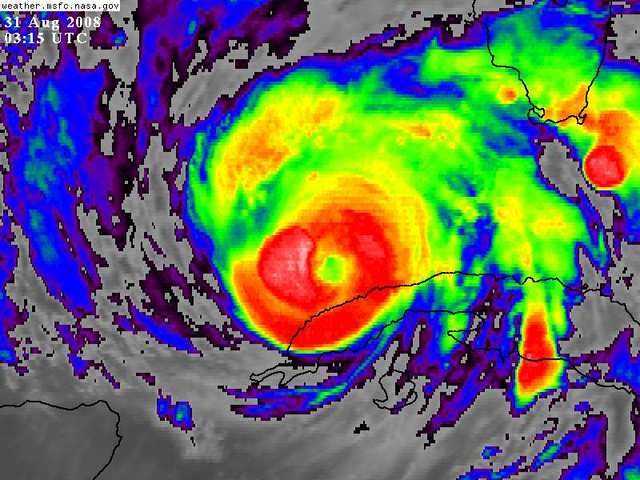
cheezyWXguy wrote:Well as you all can easily see, convection is already building up. In addition, the eye is slowly clearing, and the huge outer bands are contracting. This suggests the outer windfield is shrinking, meaning that the inner windfield may be becoming larger and more compact. Im telling you all....you are looking at all the signs of a hurricane getting ready to strengthen.
0 likes
-
HurryKane

- Category 5
- Posts: 1941
- Joined: Sun Sep 12, 2004 8:08 pm
- Location: Diamondhead, Mississippi
Re: Re:
Lowpressure wrote:MisUndrstd wrote:Well, Ixolib I'm not really the one to ask but I will inject this. Listening to Mayor Ray Nagin tonight he called Gustav the "Mother" of all storms and also said this would be the Storm of the Century. Does anyone else think these statements he made will be true? According to his statements Gustav would be worse then what Camille or Katrina were. Any thoughts?
I venture to guess he was referring to it being a direct hit to his city. Making it the worse hit for NO. If Gus comes in just south of the city, surge would be huge backing up into the lake. River levels are higher this time due to recent mid west flooding than the were for Katrina. It has the potential to be worse, but he should choose his words wisely.
I'm of two minds on this one.
1) He HAS to get people to leave, and strong language is the way to do it. But...
2) If something amazing happens and this storm's effects on NOLA are lesser than what they're currently forecast to be, people will say he's crazy (which, no arguing there, but some people will say he cried wolf).
50/50 chance of win or fail on this one.
0 likes


Re: Cat. 4 Hurricane Gustav in Gulf of Mexico
Ixolib wrote:In terms of surge potential:
Katrina was a cat 5/4 in the Gulf and was HUGE. Widespread surge.
Camille was a cat 5/4 in the Gulf and was SMALL. Comparatively smaller surge.
How does Gustav's size - or potential size - compare to Camille and Katrina?
Small and tight or huge and wide?????
Wasn't it Katrina's overall size that caused the historical surge issue in MS?
It's pretty odd to see Camille referred to as SMALL and Comparatively smaller... but understanding what you went through with Katrina I can see the comparison.
I believe that you have hit the nail on the head regarding judging the potential surge impact of Gustav. I agree with you that the combination of the size and intensity combines to create the worse impacts. It will be interesting to compare over the next 24-36 hours how the size and intensity of the windfield for Gustav compares with Katrina. That will probably have more bearing on the eventual surge that is seen at landfall rather than the actual landfall intensity. As we saw with Katrina, a late weakening didn't have a corresponding reduction in the surge impacts.
What tools do we have available to judge these developments over the next 24-36 hours?
0 likes
-
ConvergenceZone
.gif)
- Category 5
- Posts: 5241
- Joined: Fri Jul 29, 2005 1:40 am
- Location: Northern California
Re: Cat. 4 Hurricane Gustav in Gulf of Mexico
Even if this doesn't turn out to be a major hurricane, it's best to prepare like it is...The conditions in the gulf are far from ideal, so we are not going to see a monster Cat 5 slam into the coast. The conditions for that to happen, just aren't there like they have been for previous storms. The warm water is the only thing it has going for it... However, I still hope people take this storm seriously. Even a high Cat 2 or Cat 3 storm can do quite a bit of damage.....
0 likes
-
6SpeedTA95
- Category 5
- Posts: 1206
- Joined: Wed Oct 19, 2005 3:25 pm
- Location: Oklahoma
- Contact:
Re: Re:
cheezyWXguy wrote:HURAKAN wrote:
Well as you all can easily see, convection is already building up. In addition, the eye is slowly clearing, and the huge outer bands are contracting. This suggests the outer windfield is shrinking, meaning that the inner windfield may be becoming larger and more compact. Im telling you all....you are looking at all the signs of a hurricane getting ready to strengthen.

The outter bands on the west side of the storm are contracting because of the wind shear. It looks rather unimpressive on the WV loop compared with earlier today.
0 likes


-
Sean in New Orleans

- Category 5
- Posts: 1794
- Joined: Thu Aug 28, 2003 7:26 pm
- Location: New Orleans, LA 30.0N 90.0W
- Contact:
Re: Cat. 4 Hurricane Gustav in Gulf of Mexico
Just wanted to stop in and say Hello. It doesn't look good. Looks like Lafayette. I'm too upset to analyze and pinpoint this system. Ya'll have fun tracking the system minute by minute. I just can't do it. Going to Picayune tomorrow and maybe Atlanta after that if the City of New Orleans closes down for a spell. Peace.....
0 likes

Re: Cat. 4 Hurricane Gustav in Gulf of Mexico
http://www.nco.ncep.noaa.gov/pmb/nwprod ... 0_036l.gif
Looks like newest GFS will be a hair east...or at least the vort max is...on the 18z the 42 hour vort max was a little west of where this takes it. This one has it ON TOP of plaquemines parrish
Looks like newest GFS will be a hair east...or at least the vort max is...on the 18z the 42 hour vort max was a little west of where this takes it. This one has it ON TOP of plaquemines parrish
0 likes
-
HurryKane
- Category 5
- Posts: 1941
- Joined: Sun Sep 12, 2004 8:08 pm
- Location: Diamondhead, Mississippi
Re: Cat. 4 Hurricane Gustav in Gulf of Mexico
Sean in New Orleans wrote:Just wanted to stop in and say Hello. It doesn't look good. Looks like Lafayette. I'm too upset to analyze and pinpoint this system. Ya'll have fun tracking the system minute by minute. I just can't do it. Going to Picayune tomorrow and maybe Atlanta after that if the City of New Orleans closes down for a spell. Peace.....
Best of luck to you and safe traveling. *hug*
0 likes
Re: Cat. 4 Hurricane Gustav in Gulf of Mexico
Good luck Sean...we'll be thinking about you. I know how surreal this is got to be for folks in that area. I can hear the sadness in my mom's voice...even though I think she will be just far enough away to avoid a Katrina level surge in Pascagoula.
0 likes
-
jasons2k

- Storm2k Executive

- Posts: 8290
- Age: 52
- Joined: Wed Jul 06, 2005 12:32 pm
- Location: The Woodlands, TX
Re: Cat. 4 Hurricane Gustav in Gulf of Mexico
HDGator wrote:It's pretty odd to see Camille referred to as SMALL and Comparatively smaller... but understanding what you went through with Katrina I can see the comparison.
Camille was a compact hurricane, and one reason why it was able to make LF as a Cat. 5.
0 likes
-
peteywheatstraw
- Tropical Low

- Posts: 24
- Joined: Sun Sep 10, 2006 1:40 am
Re: Cat. 4 Hurricane Gustav in Gulf of Mexico
Highest Winds at Baton Rouge Metro Airport north of the city from prior storms:
(mph)
1965 Betsy 92
1992 Andrew 70
2005 Katrina 49
2005 Rita 53
2008 Gustav ?
(mph)
1965 Betsy 92
1992 Andrew 70
2005 Katrina 49
2005 Rita 53
2008 Gustav ?
0 likes
-
6SpeedTA95
- Category 5
- Posts: 1206
- Joined: Wed Oct 19, 2005 3:25 pm
- Location: Oklahoma
- Contact:
-
MisUndrstd
- Tropical Low
- Posts: 10
- Joined: Sun Mar 23, 2008 12:14 pm
Re: Cat. 4 Hurricane Gustav in Gulf of Mexico
Hello32020 wrote:Ugg at the person who just called into CNN from the ninth ward saying they were sleeping in until morning to evacuate. The highways are gonna be packed by then probably.
EDIT: Aren't they already packed now...
Hello,
The highways are packed I can verify this as I was just out in it. On I-10 East through Gulfport/Biloxi traffic is NOT flowing, it is at a crawl... same with the other routes in Mississippi that Louisiana's folks are taking. Right off the Interstate gas stations are running out of gas. You might find a station with Premium gas but Regular is kind of hard to come by. So crawling along the Interstate will do nothing but burn up precious fuel. Tomorrow I suppose it will be worse, especially since many in Mississippi will be under evacuation orders. I'm sure the evacuation routes all over Louisiana are just as crammed packed. If I were him I might try leaving in the middle of the night, like about 2 am or 3 am but I doubt it will make much of difference. Waiting to leave is just prolonging your misery!
0 likes
-
cheezyWXguy

- Category 5
- Posts: 6282
- Joined: Mon Feb 13, 2006 12:29 am
- Location: Dallas, TX
Re: Re:
6SpeedTA95 wrote:cheezyWXguy wrote:HURAKAN wrote:
Well as you all can easily see, convection is already building up. In addition, the eye is slowly clearing, and the huge outer bands are contracting. This suggests the outer windfield is shrinking, meaning that the inner windfield may be becoming larger and more compact. Im telling you all....you are looking at all the signs of a hurricane getting ready to strengthen.
The outter bands on the west side of the storm are contracting because of the wind shear. It looks rather unimpressive on the WV loop compared with earlier today.
Just wait.
0 likes
-
6SpeedTA95
- Category 5
- Posts: 1206
- Joined: Wed Oct 19, 2005 3:25 pm
- Location: Oklahoma
- Contact:
Re: Cat. 4 Hurricane Gustav in Gulf of Mexico
MisUndrstd wrote:Hello32020 wrote:Ugg at the person who just called into CNN from the ninth ward saying they were sleeping in until morning to evacuate. The highways are gonna be packed by then probably.
EDIT: Aren't they already packed now...
Hello,
The highways are packed I can verify this as I was just out in it. On I-10 East through Gulfport/Biloxi traffic is NOT flowing, it is at a crawl... same with the other routes in Mississippi that Louisiana's folks are taking. Right off the Interstate gas stations are running out of gas. You might find a station with Premium gas but Regular is kind of hard to come by. So crawling along the Interstate will do nothing but burn up precious fuel. Tomorrow I suppose it will be worse, especially since many in Mississippi will be under evacuation orders. I'm sure the evacuation routes all over Louisiana are just as crammed packed. If I were him I might try leaving in the middle of the night, like about 2 am or 3 am but I doubt it will make much of difference. Waiting to leave is just prolonging your misery!
Are they focusing on people in low lying areas first and foremost with evac procedure?
0 likes
Re: Cat. 4 Hurricane Gustav in Gulf of Mexico
http://www.nco.ncep.noaa.gov/pmb/nwprod ... 0_042l.gif
Vort max right over NO on this one...I would expect GFDl and HWRF will shift a hair east as well...Probably spliting the difference between Plaquemines and LaFourche...just a guess though. Either way as we get closer actually landfall point could end up being Buras-Triumph or Grand Isle a little west of it.
Vort max right over NO on this one...I would expect GFDl and HWRF will shift a hair east as well...Probably spliting the difference between Plaquemines and LaFourche...just a guess though. Either way as we get closer actually landfall point could end up being Buras-Triumph or Grand Isle a little west of it.
Last edited by PTPatrick on Sat Aug 30, 2008 10:55 pm, edited 1 time in total.
0 likes
Who is online
Users browsing this forum: No registered users and 6 guests