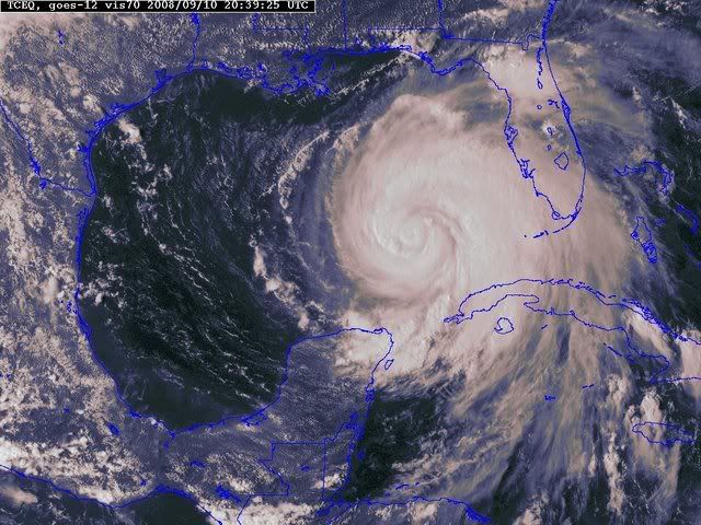
ATL: IKE Discussion

Moderator: S2k Moderators

Message
Author
HurricaneFreak

Re: Re:

#7861 Postby HurricaneFreak » Wed Sep 10, 2008 4:25 pm

RL3AO wrote:
HurricaneFreak wrote:
CronkPSU wrote:was wilma the biggest hurricane ever? i thought carla was

tip is the largest tropical cyclone, I know that for sure

No search wilma on the wikipedia u will see that wilma was biggest atlantic hurricane ever recorded on record...bigger than katrian or rita or carla but not Tip obviosly and they said wilma was most intense hurricane too..smallest eye recorded...but Ike is definitly not gona be a cat 5 katrina or wilma


I'm pretty sure Gilbert was larger than Wilma.

Wrong again search the wikipedia lol it actually says this
http://en.wikipedia.org/wiki/Hurricane_Wilma
"Hurricane Wilma was the most intense hurricane ever recorded in the Atlantic basin"
"ranking Wilma among the top 5 costliest hurricanes ever recorded in the Atlantic and the third costliest storm in U.S. history."
Most intense Atlantic hurricanes
Intensity is measured solely by central pressure Rank Hurricane Season Min. pressure
1 Wilma 2005 882 mbar (hPa)
2 Gilbert 1988 888 mbar (hPa)
3 "Labor Day" 1935 892 mbar (hPa)
4 Rita 2005 895 mbar (hPa)
5 Allen 1980 899 mbar (hPa)
6 Katrina 2005 902 mbar (hPa)
7 Camille 1969 905 mbar (hPa)
Mitch 1998 905 mbar (hPa)
Dean 2007 905 mbar (hPa)
10 Ivan 2004 910
Wilma," the first time the 'W' name was used in the Atlantic Basin since alphabetical naming began in 1950.
The 13th hurricane of the season, Wilma broke the record set in 1969 for most storms of hurricane strength in one season for the Atlantic Basin.
The pressure measured in Wilma, 882 mb, is currently the lowest recorded pressure for a tropical cyclone in the Atlantic Basin, as well as the lowest pressure for any cyclone measured in the Western Hemisphere.
At its peak intensity, the eye of Wilma was about 3 miles (5 km) in diameter, the smallest known eye of an Atlantic hurricane
0 likes   

User avatar
Aristotle
Tropical Storm
Tropical Storm
Posts: 141
Age: 59
Joined: Wed Aug 27, 2008 8:16 pm
Location: Crowley, TX

Re: ATL IKE: Category 2 - Discussion

#7862 Postby Aristotle » Wed Sep 10, 2008 4:25 pm

He's already a Cat 2 and has hundreds of miles of hot water to pass over. What makes you say it won't hit major status again?[/quote]


Insanity. The only thing keep this in check is the dry air and the erwc. Otherwise Poof![/quote]

Its a cat 2 in name, but recon doesnt show winds that strong in any recent passes.[/quote]

Disagree dwg71. What I think you mean is that it's not a cat 2 according to winds. Obviously there are other factors that go into making a Hurc a certain intensity. Wind is not the only consideration. How about structure and environment?
Am I close?
0 likes   

HurricaneFreak

Re: ATL IKE: Category 2 - Discussion

#7863 Postby HurricaneFreak » Wed Sep 10, 2008 4:25 pm

But dont worry ike will definitly not be like wilma
0 likes   

Weatherfreak000

#7864 Postby Weatherfreak000 » Wed Sep 10, 2008 4:26 pm

I'd venture to say the storm is deepening thunderstorm activity and overall organization but the dry air/shear combo have hurt its ability to stabilize a very solid core...until just recently. No worries...Ike definitely has "The Fist"...rapid deepening to a Cat 4 tonight i'll estimate.
0 likes   

User avatar
KWT
Category 5
Category 5
Posts: 31415
Joined: Tue Aug 17, 2004 11:02 am
Location: UK!!!

Re:

#7865 Postby KWT » Wed Sep 10, 2008 4:26 pm

dwg71 wrote:Why arent the winds matching the pressures?? I think pressures usually drop this time of day slightly. But, im seeing surface winds lately that are closer to 65KTs than 85KTS.


That would be because of the double eyewall structure, it has really spready the highest winds out quite a long way for a system thats only a cat-2, should only increase in size in the next few days over the gulf.
0 likes   

Nederlander
S2K Supporter
S2K Supporter
Posts: 1250
Joined: Sat Jul 19, 2008 4:28 pm
Location: Conroe, TX

Re: ATL IKE: Category 2 - Discussion

#7866 Postby Nederlander » Wed Sep 10, 2008 4:27 pm

Aristotle wrote:He's already a Cat 2 and has hundreds of miles of hot water to pass over. What makes you say it won't hit major status again?


Insanity. The only thing keep this in check is the dry air and the erwc. Otherwise Poof![/quote]

Its a cat 2 in name, but recon doesnt show winds that strong in any recent passes.[/quote]

Disagree dwg71. What I think you mean is that it's not a cat 2 according to winds. Obviously there are other factors that go into making a Hurc a certain intensity. Wind is not the only consideration. How about structure and environment?
Am I close?[/quote]

Saffir-Simpson is based solely on WIND... not pressure... just wind
0 likes   

User avatar
funster
Category 3
Category 3
Posts: 816
Joined: Sat Dec 29, 2007 4:27 pm
Location: North Dallas

#7867 Postby funster » Wed Sep 10, 2008 4:29 pm

I think some or confusing size with intensity.
0 likes   

dwg71
Category 5
Category 5
Posts: 2349
Joined: Wed Jun 08, 2005 4:34 pm

#7868 Postby dwg71 » Wed Sep 10, 2008 4:30 pm

Safer Simpson Scale uses wind as its only criteria (other than being tropical in nature) and 83 KT winds are the beginning of that. They had a 93Kt wind some 2 1/2 hours ago. nothing near that since.

Lets see if it continues to deepen, intensity is a tough forecast. just ask the NHC, they will fess up to it.
0 likes   

Weatherfreak000

#7869 Postby Weatherfreak000 » Wed Sep 10, 2008 4:30 pm

One other note...


24 hours ago...here was the forecast by the NHC..

24HR VT 10/1800Z 24.3N 86.6W 90 KT

Currently we are...

INITIAL 10/2100Z 24.5N 86.1W 85 KT


The North and East trend has been persistent for the past 24 hours...Intensity forecasting however has been very good.
0 likes   

jinftl
Category 5
Category 5
Posts: 4312
Joined: Tue Aug 31, 2004 4:47 pm
Location: fort lauderdale, fl

Re: ATL IKE: Category 2 - Discussion

#7870 Postby jinftl » Wed Sep 10, 2008 4:31 pm

For comparison....Ike has a windfield in the range of the 2005 beasts.

from NHC archive, max windfield diamater reached:

Katrina - Hurricane force out 110 miles from center, Tropical Storm force out 205 miles from center

Rita- Hurricane force out 85 miles from center. Tropical storm force out 205 miles from center.

Wilma - Hurricane force out 90 miles from center, Tropical Storm force out 230 miles from center (florida landfall)

funster wrote:
inda_iwall wrote:So what is Ike's size say in relation to Ivan or Katrina?


IKE IS A VERY LARGE TROPICAL CYCLONE. HURRICANE FORCE WINDS EXTEND
OUTWARD UP TO 90 MILES...150 KM...FROM THE CENTER...AND TROPICAL
STORM FORCE WINDS EXTEND OUTWARD UP TO 205 MILES...335 KM.


With Katrina the hurricane force winds extended out 120 miles but if Ike keeps
growing he will probably reach or exceed that.
0 likes   

User avatar
KWT
Category 5
Category 5
Posts: 31415
Joined: Tue Aug 17, 2004 11:02 am
Location: UK!!!

#7871 Postby KWT » Wed Sep 10, 2008 4:31 pm

The thing is it seems like this hurricane hasn't got your normal wind profile, in other words winds at the surface seem to be higher then aloft, the dropsonde earlier showed that very well indeed.
0 likes   

User avatar
HURAKAN
Professional-Met
Professional-Met
Posts: 46086
Age: 38
Joined: Thu May 20, 2004 4:34 pm
Location: Key West, FL
Contact:

#7872 Postby HURAKAN » Wed Sep 10, 2008 4:33 pm

Image
0 likes   

jinftl
Category 5
Category 5
Posts: 4312
Joined: Tue Aug 31, 2004 4:47 pm
Location: fort lauderdale, fl

Re:

#7873 Postby jinftl » Wed Sep 10, 2008 4:35 pm

Today is the 3rd full day of cloudiness in south fl due to ike!!! Bring back the sun to the sunshine state!

HURAKAN wrote:Image
0 likes   

inda_iwall

Re: ATL IKE: Category 2 - Discussion

#7874 Postby inda_iwall » Wed Sep 10, 2008 4:35 pm

This storm has a LOOONGG way to become an Ivan or Katrina, its ACE numbers dont even compare.
Use this document for reference.
http://katrina.impactweather.com/hsi/hsi.pdf
0 likes   

weunice
Tropical Storm
Tropical Storm
Posts: 143
Joined: Mon Aug 29, 2005 10:08 am
Location: Denham Springs, LA

Re: ATL IKE: Category 2 - Discussion

#7875 Postby weunice » Wed Sep 10, 2008 4:36 pm

While Hurricane Gilbert has since become the second most intense hurricane ever observed in the Atlantic basin, use of radius of outermost closed isobar statistics indicate it is the largest Atlantic tropical cyclone observed since 1988.[16]

from Wikipedia article on Atlantic Hurricanes ...
0 likes   

User avatar
ConvergenceZone
Category 5
Category 5
Posts: 5194
Joined: Fri Jul 29, 2005 1:40 am
Location: Northern California

Re: ATL IKE: Category 2 - Discussion

#7876 Postby ConvergenceZone » Wed Sep 10, 2008 4:40 pm

HURAKAN , your pictures aren't showing on my computer for some reason....
0 likes   

loro-rojo
Tropical Depression
Tropical Depression
Posts: 97
Joined: Tue Aug 08, 2006 7:11 pm
Location: San Juan, PR

Re: ATL IKE: Category 2 - Discussion

#7877 Postby loro-rojo » Wed Sep 10, 2008 4:42 pm

Wrong again search the wikipedia lol it actually says this
http://en.wikipedia.org/wiki/Hurricane_Wilma
"Hurricane Wilma was the most intense hurricane ever recorded in the Atlantic basin"
"ranking Wilma among the top 5 costliest hurricanes ever recorded in the Atlantic and the third costliest storm in U.S. history."
Most intense Atlantic hurricanes
Intensity is measured solely by central pressure Rank Hurricane Season Min. pressure
1 Wilma 2005 882 mbar (hPa)
2 Gilbert 1988 888 mbar (hPa)
3 "Labor Day" 1935 892 mbar (hPa)
4 Rita 2005 895 mbar (hPa)
5 Allen 1980 899 mbar (hPa)
6 Katrina 2005 902 mbar (hPa)
7 Camille 1969 905 mbar (hPa)
Mitch 1998 905 mbar (hPa)
Dean 2007 905 mbar (hPa)
10 Ivan 2004 910
Wilma," the first time the 'W' name was used in the Atlantic Basin since alphabetical naming began in 1950.
The 13th hurricane of the season, Wilma broke the record set in 1969 for most storms of hurricane strength in one season for the Atlantic Basin.
The pressure measured in Wilma, 882 mb, is currently the lowest recorded pressure for a tropical cyclone in the Atlantic Basin, as well as the lowest pressure for any cyclone measured in the Western Hemisphere.
At its peak intensity, the eye of Wilma was about 3 miles (5 km) in diameter, the smallest known eye of an Atlantic hurricane


Wow... you first sound like a complete jerk by telling someone "wrong again", and then you present your evidence that Wilma was the largest Atlantic hurricane by posting data that talks about the intensity of Wilma.

We are talking about the size, not intensity of Gilbert and Wilma. You might want to do your research before calling someone out like you did.
0 likes   

pablolopez26
Tropical Storm
Tropical Storm
Posts: 137
Joined: Wed Aug 27, 2008 5:10 pm

#7878 Postby pablolopez26 » Wed Sep 10, 2008 4:44 pm

Everyone relax... Remember Woooosaaaahhhh...

Lets try to see if we can keep everything relaxed throughout the duration of this Hurricane.
0 likes   

HurricaneFreak

Re: ATL IKE: Category 2 - Discussion

#7879 Postby HurricaneFreak » Wed Sep 10, 2008 4:46 pm

Hre is wilma on left,tip on right and katrina and rita and gilbert last at bottom at thre biggest size to compare with ike what do you think?
Image
Last edited by HurricaneFreak on Wed Sep 10, 2008 4:47 pm, edited 1 time in total.
0 likes   

User avatar
MGC
S2K Supporter
S2K Supporter
Posts: 5899
Joined: Sun Mar 23, 2003 9:05 pm
Location: Pass Christian MS, or what is left.

Re: ATL IKE: Category 2 - Discussion

#7880 Postby MGC » Wed Sep 10, 2008 4:46 pm

By far the greatest threat Ike poses is the surge. Only a small area will receive the Cat-4 or Cat-3 winds. I will take wind over water any day. Give me a couple of Andrews or Charleys compared to what Ike will do if he hits a densely populated area that is surge prone. The fact are that Ike is developing a large wind field. That large wind field is going to produce a large surge, perhaps approaching 20+ feet. Add to that surge the wind driven waves and little on the coast will survive. Just take a look at the bridges Ivan and Katrina destroyed. Are the bridges in Texas 30 feet above the water? If not then they are likely to be destroyed. If Ike keeps growing in size and intensity then another Katrina type event is in the cards. The tides along the Mississippi coast are up today. Ike is pushing a huge waveof water. Please don't let Texas end up like Louisiana or Mississippi after Katrina. If you live below 30 feet above sea level and are in the warning area please get out. I don't mean to scare anyone but a massive storm surge must be respected. Katrina totally destroyed the coast line here in Mississippe and I'm afraid Ike might just do the same to Texas........MGC
0 likes   


Return to “2008”

Who is online

Users browsing this forum: No registered users and 3 guests