ATL: IKE Discussion

Moderator: S2k Moderators

Message
Author
Nederlander
S2K Supporter
S2K Supporter
Posts: 1250
Joined: Sat Jul 19, 2008 4:28 pm
Location: Conroe, TX

Re: ATL IKE: Category 2 - Discussion

#7921 Postby Nederlander » Wed Sep 10, 2008 5:32 pm

Cape Verde wrote:The company I work for (a major oil company) has its own weather team. We're not going to rely on the weatherbabes on the Weather Channel to base decisions costing millions of dollars on.

We closed the Houston office effective tonight. Landfall from our team at 4 pm CDT predicted landfall in Matagorda Bay, but allowed that it might shift to Freeport.

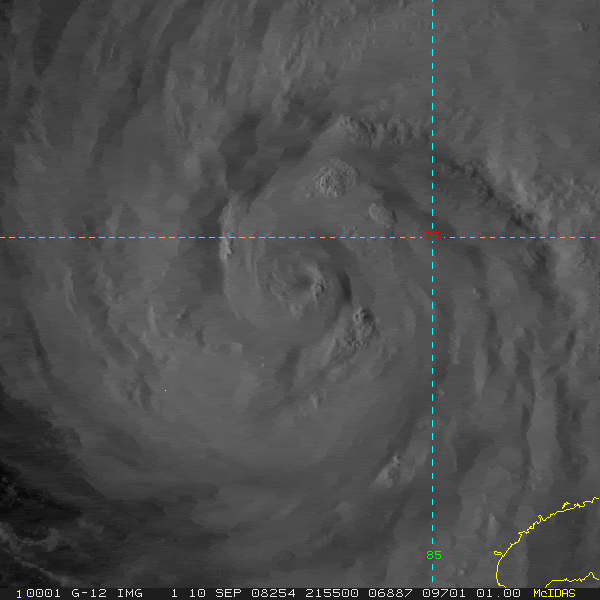
Either way, Houston gets this bigtime. Galveston gets the surge, and if the models continue shifting east, it's 1900 all over again.


Not quite "1900 all over again" ... Galveston has a 17 foot tall seawall that is 16 feet thick at its base, which was built as a result of the 1900 storm
0 likes   

MBryant
Category 1
Category 1
Posts: 416
Joined: Fri Aug 27, 2004 7:13 pm
Location: Orange, Texas

Re: ATL IKE: Category 2 - Discussion

#7922 Postby MBryant » Wed Sep 10, 2008 5:32 pm

Emmett appears to be comfortable gambling with people's lives. If you're in a flood prone area, does it really matter that you drown from freshwater flooding rather than saltwater flooding? He takes a good point to the silly extreme.

He should have said, "If your house hasn't flooded in the last 20 years and you're not in danger from falling trees and are in reasonably good health, evacuation isn't necessary."

After a little thought about the Tsunamis, I edited the part about salt water deaths.
0 likes   

rtd2
Category 5
Category 5
Posts: 1183
Joined: Tue Aug 12, 2003 12:45 pm
Location: Biloxi, MS

Re: Re:

#7923 Postby rtd2 » Wed Sep 10, 2008 5:33 pm

fasterdisaster wrote:
Nexus wrote:Image


Definitely expect recon to find an increase in winds soon.


sure can see that weak or dry spot just above eyewall on that shot
0 likes   

pablolopez26
Tropical Storm
Tropical Storm
Posts: 137
Joined: Wed Aug 27, 2008 5:10 pm

Re: ATL IKE: Category 2 - Discussion

#7924 Postby pablolopez26 » Wed Sep 10, 2008 5:33 pm

survived alica wrote:according to my source, that tune is about to change pretty soon here. a very big conference call going on right now.


I can imagine that call involves the NHC, Governor, and State Judge, and who knows who else.

What do you think the end result will be Survived?
0 likes   

User avatar
KWT
Category 5
Category 5
Posts: 31415
Joined: Tue Aug 17, 2004 11:02 am
Location: UK!!!

#7925 Postby KWT » Wed Sep 10, 2008 5:33 pm

Sadly some of the models, esp the ECM really would give Texas a pretty historic hurricane. Still early in the day of course but with such a large hurricane even a borderline 2/3 is going to relaly whack places way to the NE of the center with hurricane force winds and so even if the track stays close to where it is now Houston will get some pretty hefty winds I'd think...

ike's starting to get a bit of a better structure once again...
0 likes   

CrazyC83
Professional-Met
Professional-Met
Posts: 34002
Joined: Tue Mar 07, 2006 11:57 pm
Location: Deep South, for the first time!

Re: Re:

#7926 Postby CrazyC83 » Wed Sep 10, 2008 5:33 pm

fasterdisaster wrote:
Nexus wrote:Image


Definitely expect recon to find an increase in winds soon.


As soon as they get into the NE quad outer band, where the Cat 2 winds were at last pass (they haven't been there in over 2 hours).
0 likes   

User avatar
cycloneye
Admin
Admin
Posts: 145382
Age: 68
Joined: Thu Oct 10, 2002 10:54 am
Location: San Juan, Puerto Rico

Re: ATL IKE: Category 2 - Discussion

#7927 Postby cycloneye » Wed Sep 10, 2008 5:34 pm

Even if Ike stays as it is now at 100 mph cat 2,this will be a hurricane to remember for tens of thousands of people even millons that will be affected one way or another,in a vast area.
0 likes   

rtd2
Category 5
Category 5
Posts: 1183
Joined: Tue Aug 12, 2003 12:45 pm
Location: Biloxi, MS

Re: ATL IKE: Category 2 - Discussion

#7928 Postby rtd2 » Wed Sep 10, 2008 5:35 pm

MBryant wrote:Emmett appears to be comfortable gambling with people's lives. If you're in a flood prone area, does it really matter that you drown from freshwater flooding rather than saltwater flooding? He takes a good point to the silly extreme.

He should have said, "If your house hasn't flooded in the last 20 years and you're not in danger from falling trees and are in reasonably good health, evacuation isn't necessary."

After a little thought about the Tsunamis, I edited the part about salt water deaths.


I dont see anything wrong or a GAMBLE... of course we are living AK (After katrina ) and no one wants that nightmare scenerio again!! if a person feels they arent safe and should leave then leave! dont wait on the govt.
Last edited by rtd2 on Wed Sep 10, 2008 5:37 pm, edited 1 time in total.
0 likes   

User avatar
Cape Verde
Category 2
Category 2
Posts: 564
Age: 69
Joined: Tue Aug 31, 2004 5:53 pm
Location: Houston area

Re: ATL IKE: Category 2 - Discussion

#7929 Postby Cape Verde » Wed Sep 10, 2008 5:35 pm

MBryant wrote:
Emmett stressed that no one should leave a home unless there is the danger of having storm surge enter it.

"Most people in Harris County shouldn't evacuate in any case," he said. "Unless you are in danger of water coming into your house, and I mean storm surge, not rainfall, you need to stay put."

"Wow thats is a very level headed statement.....no hype whatsoever!"

Emmett appears to be comfortable gambling with people's lives. If you're in a flood prone area, does it really matter that you drown from freshwater flooding rather than saltwater flooding? He takes a good point to the silly extreme. Most drowning deaths have NOTHING to do with salt water.

He should have said, "If your house hasn't flooded in the last 20 years and you're not in danger from falling trees and are in reasonably good health, evacuation isn't necessary."


Well, it's still mostly a free country, and if I want to leave, that's my business. Maybe I don't want to live in a town with no power in sweltering heat. I don't need Emmett's permission to back out of my driveway.
0 likes   

User avatar
Texas Snowman
Storm2k Moderator
Storm2k Moderator
Posts: 6179
Joined: Fri Jan 25, 2008 11:29 am
Location: Denison, Texas

Re: ATL IKE: Category 2 - Discussion

#7930 Postby Texas Snowman » Wed Sep 10, 2008 5:37 pm

Not sure if any of you saw the post I made a page back or so in which I quoted Air Force Met on the Ike Model thread.

He seemed to indicate that NHC wanted to move the track to the east on last advisory, but didn't want to do so just yet.

He also said they were hinting at a landfall location that would give Houston its worst wack since Carla.

Wonder if that is in the Freeport area? I would think - and that's purely speculation on my part - that Air Force Met would be privy to some good information that the rest of us are not.
0 likes   

User avatar
Cape Verde
Category 2
Category 2
Posts: 564
Age: 69
Joined: Tue Aug 31, 2004 5:53 pm
Location: Houston area

Re: ATL IKE: Category 2 - Discussion

#7931 Postby Cape Verde » Wed Sep 10, 2008 5:38 pm

Nederlander wrote:
Not quite "1900 all over again" ... Galveston has a 17 foot tall seawall that is 16 feet thick at its base, which was built as a result of the 1900 storm


Yeah, some of Galveston. There's lots of development unprotected by a seawall.
0 likes   

rtd2
Category 5
Category 5
Posts: 1183
Joined: Tue Aug 12, 2003 12:45 pm
Location: Biloxi, MS

Re: ATL IKE: Category 2 - Discussion

#7932 Postby rtd2 » Wed Sep 10, 2008 5:38 pm

Cape Verde wrote:
MBryant wrote:
Emmett stressed that no one should leave a home unless there is the danger of having storm surge enter it.

"Most people in Harris County shouldn't evacuate in any case," he said. "Unless you are in danger of water coming into your house, and I mean storm surge, not rainfall, you need to stay put."

"Wow thats is a very level headed statement.....no hype whatsoever!"

Emmett appears to be comfortable gambling with people's lives. If you're in a flood prone area, does it really matter that you drown from freshwater flooding rather than saltwater flooding? He takes a good point to the silly extreme. Most drowning deaths have NOTHING to do with salt water.

He should have said, "If your house hasn't flooded in the last 20 years and you're not in danger from falling trees and are in reasonably good health, evacuation isn't necessary."


Well, it's still mostly a free country, and if I want to leave, that's my business. Maybe I don't want to live in a town with no power in sweltering heat. I don't need Emmett's permission to back out of my driveway.


bingo
0 likes   

User avatar
Texas Snowman
Storm2k Moderator
Storm2k Moderator
Posts: 6179
Joined: Fri Jan 25, 2008 11:29 am
Location: Denison, Texas

Re: ATL IKE: Category 2 - Discussion

#7933 Postby Texas Snowman » Wed Sep 10, 2008 5:40 pm

I've got to be honest about Galveston's seawall. After having been to G-Island the past two summers with my wife and kids, I'm not sure that sea wall is still 17 feet in all places.

Seems a little bit lower to me - could it have settled over a century - or was my height judgment just off that much?
0 likes   

Nexus
Tropical Storm
Tropical Storm
Posts: 137
Joined: Sat Sep 11, 2004 12:13 am

#7934 Postby Nexus » Wed Sep 10, 2008 5:41 pm

Ike now entering a very hospitable environment, at least OHC wise.

Ocean Heat Content & Forecast Track (18z):

Image
0 likes   

Myersgirl
Tropical Storm
Tropical Storm
Posts: 216
Joined: Fri Jul 23, 2004 7:32 pm
Location: Fort Myers
Contact:

Re: ATL IKE: Category 2 - Discussion

#7935 Postby Myersgirl » Wed Sep 10, 2008 5:42 pm

There is a beautifully written book about the 1900's hurricane by by Eric Larson "Issac's Storm" A must read non-fiction for those Texas posters for sure, this Florida girl loved it also
0 likes   

pablolopez26
Tropical Storm
Tropical Storm
Posts: 137
Joined: Wed Aug 27, 2008 5:10 pm

Re: ATL IKE: Category 2 - Discussion

#7936 Postby pablolopez26 » Wed Sep 10, 2008 5:42 pm

Texas Snowman wrote:I've got to be honest about Galveston's seawall. After having been to G-Island the past two summers with my wife and kids, I'm not sure that sea wall is still 17 feet in all places.

Seems a little bit lower to me - could it have settled over a century - or was my height judgment just off that much?


Nope your right, im not sure if that seawall does reach 17 feet in some places. But hey a seawall is better than no wall.
0 likes   

User avatar
opera ghost
Category 4
Category 4
Posts: 909
Joined: Mon Sep 08, 2003 4:40 pm
Location: Houston, Texas

Re: ATL IKE: Category 2 - Discussion

#7937 Postby opera ghost » Wed Sep 10, 2008 5:43 pm

Cape Verde wrote:
MBryant wrote:
Emmett stressed that no one should leave a home unless there is the danger of having storm surge enter it.

"Most people in Harris County shouldn't evacuate in any case," he said. "Unless you are in danger of water coming into your house, and I mean storm surge, not rainfall, you need to stay put."

"Wow thats is a very level headed statement.....no hype whatsoever!"

Emmett appears to be comfortable gambling with people's lives. If you're in a flood prone area, does it really matter that you drown from freshwater flooding rather than saltwater flooding? He takes a good point to the silly extreme. Most drowning deaths have NOTHING to do with salt water.

He should have said, "If your house hasn't flooded in the last 20 years and you're not in danger from falling trees and are in reasonably good health, evacuation isn't necessary."


Well, it's still mostly a free country, and if I want to leave, that's my business. Maybe I don't want to live in a town with no power in sweltering heat. I don't need Emmett's permission to back out of my driveway.


The idea is to limit traffic so that people in truly vulnerable places can get out. Rita was a disaster of an evacuation- they can't afford to have people gridlocked on the freeways fleeing the surge because people like me (I ran from Rita although I wasn't flood prone and was in a safe house because I didn't want to deal with the discomfort) decided to leave in massive numbers.

There's not enough time to clear the freeways if millions of shadow evacuees flee- the track has just been too uncertain. So I'm staying put. If worst case occurs and we're out of power long term, we'll see about heading out of town after the storm until the city is put back to rights. We'll be huddled down at home though. I've got a safe room and supplies. We're young and healthy we'll survive roughing it out.
0 likes   

MBryant
Category 1
Category 1
Posts: 416
Joined: Fri Aug 27, 2004 7:13 pm
Location: Orange, Texas

Re: ATL IKE: Category 2 - Discussion

#7938 Postby MBryant » Wed Sep 10, 2008 5:46 pm

Texas Snowman wrote:I've got to be honest about Galveston's seawall. After having been to G-Island the past two summers with my wife and kids, I'm not sure that sea wall is still 17 feet in all places.

Seems a little bit lower to me - could it have settled over a century - or was my height judgment just off that much?


While settling is certainly possible, you may have underestimated the height due to the portion of the seawall below the sand and rocks. Five feet of sand will do that.
0 likes   

inda_iwall

Re: ATL IKE: Category 2 - Discussion

#7939 Postby inda_iwall » Wed Sep 10, 2008 5:48 pm

Myersgirl wrote:There is a beautifully written book about the 1900's hurricane by by Eric Larson "Issac's Storm" A must read non-fiction for those Texas posters for sure, this Florida girl loved it also

Great book, I have been thinking about that the whole time watching this thing.
0 likes   

User avatar
cycloneye
Admin
Admin
Posts: 145382
Age: 68
Joined: Thu Oct 10, 2002 10:54 am
Location: San Juan, Puerto Rico

Re: ATL IKE / Obs / Preparations / Web Cams / All of Texas Coast

#7940 Postby cycloneye » Wed Sep 10, 2008 5:49 pm

HURRICANE IKE LOCAL STATEMENT
NATIONAL WEATHER SERVICE HOUSTON/GALVESTON TX
528 PM CDT WED SEP 10 2008

...HURRICANE WATCHES ISSUED FOR THE GULF COAST...

.AT 400 PM CDT...THE CENTER OF HURRICANE IKE WAS LOCATED
NEAR LATITUDE 24.5 NORTH...LONGITUDE 86.1 WEST OR ABOUT
625 MILES SOUTHEAST OF GALVESTON.

IKE IS MOVING TOWARD THE NORTHWEST NEAR 8 MPH. A TURN
BACK TO A WEST-NORTHWESTWARD MOTION IS EXPECTED TONIGHT...AND A
MOSTLY WEST-NORTHWESTWARD MOTION THROUGH THE CENTRAL AND WESTERN
GULF OF MEXICO IS EXPECTED OVER THE NEXT COUPLE OF DAYS.

MAXIMUM SUSTAINED WINDS ARE NEAR 100 MPH. IKE IS A CATEGORY TWO
HURRICANE ON THE SAFFIR-SIMPSON SCALE. IKE IS EXPECTED TO
BECOME A MAJOR HURRICANE WITHIN THE NEXT 24 HOURS.

IKE IS A VERY LARGE TROPICAL CYCLONE. HURRICANE FORCE WINDS
EXTEND OUTWARD UP TO 90 MILES FROM THE CENTER...AND
TROPICAL STORM FORCE WINDS EXTEND OUTWARD UP TO 200 MILES.

THE LATEST MINIMUM CENTRAL PRESSURE REPORTED BY AN AIR FORCE
RESERVE UNIT RECONNAISSANCE AIRCRAFT WAS 958 MB...28.29 INCHES.


TXZ200-213-214-235>238-112230-
/O.CAN.KHGX.HU.S.0002.000000T0000Z-000000T0000Z/
/O.NEW.KHGX.HU.A.1009.080910T2228Z-000000T0000Z/
BRAZORIA-CHAMBERS-GALVESTON-HARRIS-JACKSON-LIBERTY-MATAGORDA-
528 PM CDT WED SEP 10 2008

...HURRICANE WATCH IN EFFECT...

...NEW INFORMATION...

HURRICANE WATCHES HAVE BEEN ISSUED FOR THE TEXAS COAST WELL IN
ADVANCE OF THE USUAL 36 HOUR LEAD TIME. THIS HAS BEEN DONE TO GIVE
PERSONS ACROSS SOUTHEAST TEXAS MORE TIME TO MAKE PREPARATIONS.
THE STORM IS EXPECTED TO STRENGTHEN TO CATEGORY 4 INTENSITY WITH
WINDS PEAKING NEAR 130 MPH CLOSE TO THE EYE OF THE STORM. THE
STORM WILL LIKELY BE A VERY LARGE STORM WITH A WIND FIELD OF
SUSTAINED TROPICAL FORCE WINDS THAT COULD BLANKET A LARGE SWATH OF
THE TEXAS COAST AHEAD OF AND AT LANDFALL. THE STORM IS EXPECTED TO
MAKE LANDFALL BETWEEN MIDNIGHT AND 6 AM FRIDAY NIGHT INTO SATURDAY.

...AREAS AFFECTED...

THIS STATEMENT RECOMMENDS ACTIONS TO BE TAKEN BY PERSONS IN THE
FOLLOWING COUNTIES OR MARINE AREAS:

BRAZORIA...CHAMBERS...GALVESTON...HARRIS...JACKSON...LIBERTY...
MATAGORDA.

...WATCHES/WARNINGS...

A HURRICANE WATCH HAS BEEN ISSUED FOR THE UPPER TEXAS COAST.

NO ADDITIONAL HAZARDS ARE IN EFFECT.

...PRECAUTIONARY/PREPAREDNESS ACTIONS...

CURRENT EVACUATION INFORMATION:

ADDITIONAL EVACUATIONS MAY BE ISSUED BEFORE 630 PM...STAY TUNED.

BRAZORIA COUNTY:

A MANDATORY EVACUATION HAS BEEN ORDERED FOR ZIP ZONE 77541. A SPECIAL
NEEDS EVACUATION ORDER IS IN PLACE FOR THE ENTIRE COUNTY. A
VOLUNTARY EVACUATION IS IN PLACE FOR THE ENTIRE COUNTY. RESIDENTS
IN THE COASTAL AREAS AND THOSE REQUIRING TRANSPORTATION FROM
BRAZORIA COUNTY TO BELL COUNTY MUST RUSH THEIR PREPARATIONS TO
COMPLETION.

GALVESTON COUNTY:

A VOLUNTARY EVACUATION BEGAN THIS AFTERNOON FOR BOLIVAR
PENINSULA...THE WEST END OF GALVESTON ISLAND INCLUDING JAMAICA
BEACH...SAN LEON...BACLIFF...BAYOU VISTA...OMEGA BAY...TIKI
ISLAND...DICKINSON...KEMAH...AND CLEAR LAKE SHORES. CITIZENS MAY
ALSO CONSIDER EVACUATING IF THEY LIVE IN LOW-LYING AREAS SUBJECT
TO FLOODING OR IN MOBILE HOMES. IF YOU DECIDE TO EVACUATE...PLEASE
REMEMBER TO PACK YOUR DISASTER KIT AND IMPORTANT PAPERS.

THE GALVESTON-BOLIVAR FERRY WILL LIKELY CEASE OPERATIONS AT 11 PM
THURSDAY NIGHT.

JACKSON COUNTY:

A VOLUNTARY EVACUATION HAS BEEN INITIATED FOR THE ENTIRE COUNTY.

MATAGORDA COUNTY:

A MANDATORY EVACUATION HAS BEEN ORDERED FOR PEOPLE WHO LIVE AND
WORK SOUTH OF HIGHWAY 35. THIS MANDATORY EVACUATION INCLUDES THE
COMMUNITIES OF PALACIOS...ASHBY-BUCKEYE...EL MATON...COLLEGEPORT...
MATAGORDA...WADSWORTH...SARGENT...CEDAR LANE...CHINQUAPIN...TRES
PALACIOS OAKS...AND TIDEWATER OAKS. BLESSING IS ALSO INCLUDED IN
THE MANDATORY EVACUATION EVEN THOUGH IT IS NORTH OF HIGHWAY 35.
THE MANDATORY EVACUATION DOES NOT INCLUDE BAY CITY OR VAN VLECK.

IT IS RECOMMENDED YOU EVACUATE WITH YOUR PETS. BE SURE TO TAKE A
PET CARRIER...LEASH...VACCINATION RECORDS...AND FOOD FOR YOUR PET.
IF YOU EVACUATE TO A SHELTER...YOUR PETS WILL BE BOARDED AT A
SEPARATE FACILITY.

IF YOU HAVE NO MEANS OF TRANSPORTATION OR CANNOT FIND ANYONE TO
HELP YOU EVACUATE AND NEED ASSISTANCE...YOU CAN CONTACT
979-245-3056 OR 979-244-5318.

RESIDENTS OF MATAGORDA COUNTY WHO NEED SHELTER CAN EVACUATE TO THE
SHELTER HUB IN AUSTIN. SIGNS IN AUSTIN WILL DIRECT EVACUEES TO
OPEN SHELTERS.


...STORM SURGE AND STORM TIDE...

THE FOLLOWING TIDE LEVELS ARE BASED ON THE CURRENT FORECAST TRACK
AND FORECAST INTENSITY FOR HURRICANE IKE. THE LEVELS ARE SUBJECT
TO CHANGE BASED ON ANY FUTURE CHANGES IN THE FORECAST. IF THE
TRACK SHIFTS EASTWARD...THEN THESE LEVELS MAY BE INCREASED
DRAMATICALLY FOR THE GALVESTON BAY REGION.

TIDE LEVELS WILL EXCEED 5 FEET ABOVE MEAN LOWER LOW WATER ALONG
THE UPPER TEXAS COAST BEGINNING FRIDAY MORNING. MAXIMUM TIDE
LEVELS WILL OCCUR FRIDAY NIGHT THROUGH SATURDAY MORNING.

MAXIMUM WATER LEVELS FORECAST:
SHORELINE OF MATAGORDA BAY - 15 TO 22 FEET
COASTAL AREAS FROM MATAGORDA TO SAN LUIS PASS - 10 TO 14 FEET
COASTAL AREAS OF GALVESTON AND CHAMBERS COUNTIES AND THE
SHORES OF GALVESTON BAY - 8 TO 12 FEET

...WINDS...

NORTHEAST WINDS WILL INCREASE 20 TO 30 MPH WITH HIGHER GUSTS
AFTER 3 AM FRIDAY ALONG THE COAST. WINDS WILL STEADILY INCREASE
THROUGHOUT THE MORNING AND BY 2 PM ON FRIDAY WINDS OF 40 TO 60
MPH WITH MUCH HIGHER GUSTS WILL BE POSSIBLE ALONG THE COAST
INLAND...WINDS ALONG THE INTERSTATE 10 CORRIDOR SHOULD BE NEARING
25 TO 40 MPH SUSTAINED MAKING ELEVATED ROADWAYS POTENTIALLY
HAZARDOUS. SUSTAINED HURRICANE FORCE WINDS OF 75 MPH WILL BE
POSSIBLE BY 8 PM FRIDAY. NEAR THE EYEWALL WHICH IS FORECAST TO
COME ONSHORE MATAGORDA COUNTY SUSTAINED WINDS IN EXCESS OF 110
MPH WILL PRODUCE WIDESPREAD DAMAGE. FLYING DEBRIS WILL BE
POTENTIALLY FATAL.

IN CLOSE TO THE EYE EXTREMELY DANGEROUS WINDS WILL CAUSE EXTENSIVE
DAMAGE AND ALL MOBILE HOMES WILL BE DESTROYED.

STRUCTURAL DAMAGE WILL INCLUDE HOUSES OF POOR TO AVERAGE
CONSTRUCTION BEING DESTROYED OR SEVERELY DAMAGED. MODERATE TO
MAJOR DAMAGE OF WELL CONSTRUCTED HOUSES WILL INCLUDE FAILURE OF UP
TO ONE HALF OF ALL GABLED ROOFS. IN ADDITION....UP TO ONE QUARTER
OF EXTERIOR WALLS WILL FAIL.

ALUMINUM AND LIGHT WEIGHT STEEL ROOFS WILL BE TORN OFF BUILDINGS
AT INDUSTRIAL PARKS. PARTIAL ROOF AND EXTERIOR WALL FAILURES ARE
LIKELY AT LOW RISE APARTMENT BUILDINGS...ESPECIALLY THOSE OF POOR
TO AVERAGE CONSTRUCTION. MOST WINDOWS IN HIGH RISE OFFICE
BUILDINGS WILL BE BLOWN OUT...WITH OTHER MINOR TO MODERATE DAMAGE
POSSIBLE DUE TO SWAYING.

AIRBORNE DEBRIS OF LIGHT TO MODERATE WEIGHT WILL CAUSE ADDITIONAL
MAJOR DAMAGE...AS WELL AS INJURIES AND A FEW FATALITIES.

NEAR TOTAL POWER LOSS IS EXPECTED. UP TO ONE HALF OF ALL POWER
POLES WILL BE KNOCKED DOWN...AND HUNDREDS OF TRANSFORMERS WILL
POP. THE AVAILABILITY OF POTABLE WATER WILL BE DIMINISHED AS
FILTRATION SYSTEMS BEGIN TO FAIL.

NATURAL DAMAGE WILL INCLUDE THOUSANDS OF TREES BEING SEVERELY
DAMAGED. UP TO THREE QUARTERS OF ALL HEALTHY SMALL TO MEDIUM SIZED
TREES WILL SNAP OR BE UPROOTED...MOST COMMON ON SATURATED GROUND.
UP TO ONE HALF OF HEALTHY LARGE TREES WILL SNAP OR BE UPROOTED.
MOST NEWLY PLANTED GROUND CROPS WILL BE WIPED OUT. LIVESTOCK LEFT
OUTSIDE WILL BE INJURED...SOME CRITICALLY. A FEW LIVESTOCK DEATHS
ARE LIKELY.

...INLAND FLOODING...

WIDESPREAD RAINFALL OF 2 TO 4 INCHES WITH ISOLATED TOTALS OF 6 TO
10 INCHES POSSIBLE FRIDAY THROUGH SATURDAY. SIGNIFICANT FLOODING
WILL BE POSSIBLE IN AREAS OF HEAVIEST RAINFALL.

...TORNADOES...

AS THE STORM NEARS THE COAST FRIDAY EVENING THE THREAT OF
TORNADOES WILL INCREASE RAPIDLY. REMEMBER THE INNERMOST ROOM WITH
THE GREATEST NUMBER OF WALLS BETWEEN YOU AND THE WINDS WILL
PROVIDE YOU WITH SOME SHELTER. DO NOT GO NEAR WINDOWS.

...NEXT UPDATE...

THIS STATEMENT WILL BE UPDATED AROUND 11 PM.

$$
0 likes   


Return to “2008”

Who is online

Users browsing this forum: No registered users and 2 guests