ATL: Tropical Depression Fay
Moderator: S2k Moderators


Re:
capepoint wrote:Man, Fay is one of those women who need LOTS of time to look good in the morning
Really looks bad this morning, but with warm water, she should be able to slap on some make-up fairly quick.
UNOFFICAL FORCAST BY NOT A REAL WEATHERMAN... in my opinion she remains to the right, and will be going moreso today. Cat 1/STRONG TS max when crosses S Fla back into atlantic S of daytona. I have been preaching this for days now, why back-off now.
Some models ran a SE Florida into the Atlantic run for several runs in a row a couple days ago. It was mostly the GFDL and a few runs of the HWRF. Not sure that will happen but the other day I was thinking it was awfully persistant. Of course I thought it was wrong when the system moved further west but it did in fact put the brakes on and turn more sharply to the right!
Last edited by shaggy on Mon Aug 18, 2008 7:23 am, edited 1 time in total.
0 likes
-
Canelaw99

- S2K Supporter

- Posts: 2128
- Age: 49
- Joined: Tue Aug 31, 2004 8:27 am
- Location: Homestead, FL
Re: ATL: Tropical Storm Fay in Florida Straits
LOL Hurakan, I just saw that too....at least he said "could" 
0 likes
-
HeatherAKC

- S2K Supporter
- Posts: 286
- Joined: Thu Oct 10, 2002 2:28 pm
- Location: Miami Lakes, Florida
Re:
HURAKAN wrote:Felipe Ferro, Channel 7 in Miami, just said that it could be a hurricane by the 11 AM advisory. A little more professionalism, please.
He also just said he wouldn't be surprised to see the cone move east to cover SE Florida, but regardless, it will be messy here until possilbly even Tuesday evening.
0 likes
-
caneman
-
Toyota Thundra
- Tropical Low

- Posts: 33
- Joined: Sat Aug 16, 2008 1:35 am
- Location: Riverview FL

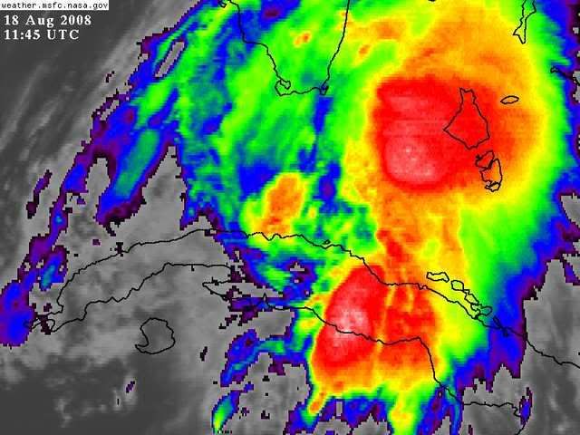
Satellite imagery this morning reminds me of Irene in 1999. All forecasts and models stuck with a SW FL coast hit while Irene went north through the everglades and directly north over Okeechobee. I'm not ruling out a similar track. Either way, all that convection on the right sure looks like weather here in Martin County will be worse than I originally thought.
0 likes
-
wxman57

- Moderator-Pro Met

- Posts: 23173
- Age: 68
- Joined: Sat Jun 21, 2003 8:06 pm
- Location: Houston, TX (southwest)
Re: ATL: Tropical Storm Fay in Florida Straits
Keep an eye on where all the heavy convection is heading. It's weakening near the center and building near the eastern Bahamas. The center follows the convection....
0 likes
-
Lowpressure

- S2K Supporter
- Posts: 2032
- Age: 59
- Joined: Sun Sep 14, 2003 9:17 am
- Location: Charlotte, North Carolina
Re: ATL: Tropical Storm Fay in Florida Straits
Somehow I knew someone was going to post something about an alien. 
0 likes
-
caneman
Folks it is looking concerning the Southern part of the LLC is now filling in and the convection seems to be drawing in closer. . PLease remember Charley went up 40 mph in these waters and was moving much faster. Not saying it's gonna happen but Fay should have even more time over water than Charley due to its slower movement.
0 likes
-
wxman57
- Moderator-Pro Met
- Posts: 23173
- Age: 68
- Joined: Sat Jun 21, 2003 8:06 pm
- Location: Houston, TX (southwest)
Re:
BPJR051 wrote:Satellite imagery this morning reminds me of Irene in 1999. All forecasts and models stuck with a SW FL coast hit while Irene went north through the everglades and directly north over Okeechobee. I'm not ruling out a similar track. Either way, all that convection on the right sure looks like weather here in Martin County will be worse than I originally thought.
I'm thinking the same thing. The way Fay is organized now, even if the center tracks up the western Peninsula the significant weather will be on the other side of the peninsula.
0 likes


Yep BPJR051 some people were suggesting there were some comprasions to Irene but we shall see still far to early to know to be honest, also if it does end up more east risk is greatly enhanced sfor states north of florida as well...
Hurakan, can't say I'm all that impressed with it, still looks like a sheared TS, granted its still producing some decent winds at flight level so I do think its slowly strengthening despite only having a small region of deeper convection near the center.
Hurakan, can't say I'm all that impressed with it, still looks like a sheared TS, granted its still producing some decent winds at flight level so I do think its slowly strengthening despite only having a small region of deeper convection near the center.
0 likes
-
caneman
Re: Re:
wxman57 wrote:BPJR051 wrote:Satellite imagery this morning reminds me of Irene in 1999. All forecasts and models stuck with a SW FL coast hit while Irene went north through the everglades and directly north over Okeechobee. I'm not ruling out a similar track. Either way, all that convection on the right sure looks like weather here in Martin County will be worse than I originally thought.
I'm thinking the same thing. The way Fay is organized now, even if the center tracks up the western Peninsula the significant weather will be on the other side of the peninsula.
Guess you'll have to wait to pull out bones
0 likes
-
MusicCityMan

- Category 1

- Posts: 483
- Joined: Sat Feb 17, 2007 10:57 pm
- Location: Somewhere in Central Florida
-
caneman
Re:
KWT wrote:wxman57, do you think its going to get back into the Atlantic again like Irene did?
caneman, it is interesting but the set-up for Fay is not even close to as good as it was for Charley.
Keep an eye on it. went up to 60 mph. Watch the water vapor loop and you'll see alot of moisture now being drawn back West. Interesting little pain in the butt storm.
0 likes

Re: ATL: Tropical Storm Fay in Florida Straits
Tallahassee NWS discussion now mentioning possible blocking pattern with Fay moving back west to the Gulf:
LONG TERM (WEDNESDAY NIGHT THROUGH MONDAY)...THE UNCERTAINTY AS
TO THE TRACK OF TROPICAL STORM FAY CONTINUES AS WE ENTER THE
EXTENDED PORTION OF THE FORECAST. GUIDANCE CONTINUES TO BUILD AN
ARGUMENT THAT A RIDGE OF HIGH PRESSURE DEVELOPING ACROSS EASTERN
U.S. WILL IMPEDE A NORTHWARD MOVEMENT OF FAY. ANY DIRECTION FAY
TAKES WILL BE BLOCKED EXCEPT FOR A WESTWARD DRIFT. BOTH THE EURO
AND GFS SUGGEST THIS. THE 00Z EURO TURNS FAY NORTHWEST IN EASTERN
GA ON SATURDAY. THE GFS HAS FAY MOVING WEST AND BREAKING BACK INTO
THE GULF ON SATURDAY. THE 00Z GFDL AND HWRF HAS THE RIDGE MOVING
EASTWARD ALLOWING FAY TO CONTINUE ON A NORTHWARD TRACK. MAY BE
GFDL AND HWRF IS UNDERESTIMATING THE RIDGE STRENGTH.
THEREFORE...THE EXTENDED DEPENDS ON WHERE AND IF FAY IS BLOCKED BY
THE RIDGE...
0 likes
Re:
Not sure I follow...the NHC said essentially the same at 8am..
SOME STRENGTHENING IS EXPECTED AS THE CENTER OF
FAY MOVES OVER WATER. FAY IS FORECAST TO BE APPROACHING HURRICANE
STRENGTH IN THE FLORIDA KEYS AND TO BECOME A HURRICANE BEFORE IT
REACHES THE FLORIDA PENINSULA.
If anything, it is probably wise to let viewers who are tuning in for the first time today know that we are dealing with a storm that has strengthened last night and is poised to make some higher degree of impact on SFL than thought last night. Going from 60mph to 74mph in 6 hours is not unimaginable for a storm either.
HURAKAN wrote:Felipe Ferro, Channel 7 in Miami, just said that it could be a hurricane by the 11 AM advisory. A little more professionalism, please.
0 likes
Who is online
Users browsing this forum: No registered users and 26 guests