Is downgraded to Tropical Storm.
216
WTNT44 KNHC 240236
TCDAT4
TROPICAL STORM DOLLY DISCUSSION NUMBER 15
NWS TPC/NATIONAL HURRICANE CENTER MIAMI FL AL042008
1100 PM EDT WED JUL 23 2008
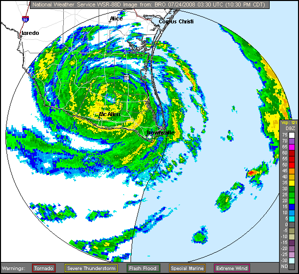
THE EYE REMAINS VERY WELL DEFINED IN THE BROWNSVILLE RADAR ALTHOUGH
IT IS BECOMING LESS DISTINCT IN INFRARED IMAGERY. THE RADAR IS
SHOWING SOME INBOUND VELOCITIES OF UP TO 78 KT OR SO AT ABOUT 2900
FT. THIS WOULD NORMALLY CORRESPOND TO MINIMAL HURRICANE FORCE AT
THE SURFACE OVER WATER...BUT NOT OVER LAND...AND DOLLY IS
DOWNGRADED TO A TROPICAL STORM ON THIS BASIS. CONTINUED WEAKENING
IS FORECAST IN ACCORD WITH THE DECAY SHIPS MODEL...WITH DOLLY
EXPECTED TO DISSIPATE OVER HIGHER TERRAIN IN 36-48 HOURS.
THE INITIAL MOTION IS 280/6. THE LARGE SCALE MODELS SHOW THE
MID-LEVEL RIDGE TO THE NORTH OF THE TROPICAL CYCLONE SLIDING
EASTWARD A LITTLE BIT...TURNING DOLLY BACK TO A WEST-NORTHWESTERLY
HEADING. THE OFFICIAL FORECAST IS CLOSE TO THE PREVIOUS ADVISORY
AND NEAR THE MIDDLE OF THE GUIDANCE ENVELOPE.
EVEN AS THE WINDS SUBSIDE...DOLLY CONTINUES TO PRODUCE VERY HEAVY
RAINS AND THE ASSOCIATED SIGNIFICANT FLOODING THREATS WILL CONTINUE
FOR ANOTHER DAY OR TWO.
FORECAST POSITIONS AND MAX WINDS
INITIAL 24/0300Z 26.5N 98.1W 60 KT
12HR VT 24/1200Z 26.8N 99.0W 40 KT...INLAND
24HR VT 25/0000Z 27.6N 100.8W 30 KT...INLAND
36HR VT 25/1200Z 28.2N 103.2W 20 KT...REMNANT LOW
48HR VT 26/0000Z...DISSIPATED
$$
FORECASTER FRANKLIN
ATL: Tropical Depression Dolly
Moderator: S2k Moderators
-
Innotech

- Category 5

- Posts: 1031
- Joined: Mon Aug 30, 2004 5:32 pm
- Location: Lafayette, Louisiana
- Contact:
Re: ATL: Dolly made landfall at South Padre Island
To think, some people were calling for this storm to fizzle out so many times. forecast-wise Im glad I was bullish on it, because she put on quite a show. I originally said Cat 3 into Corpus Christi when she was an E-Carib blob, and what DOlly did really wasnt too far off that. I learned a lot about hurricane behavior and movement from this storm and Im sure the NHC just gained a bit as well.
If this is the sort of season we have to look forward to then I can only say

If this is the sort of season we have to look forward to then I can only say
0 likes
-
CrazyC83
- Professional-Met

- Posts: 34315
- Joined: Tue Mar 07, 2006 11:57 pm
- Location: Deep South, for the first time!
Re: ATL: Dolly made landfall at South Padre Island
Innotech wrote:To think, some people were calling for this storm to fizzle out so many times. forecast-wise Im glad I was bullish on it, because she put on quite a show. I originally said Cat 3 into Corpus Christi when she was an E-Carib blob, and what DOlly did really wasnt too far off that. I learned a lot about hurricane behavior and movement from this storm and Im sure the NHC just gained a bit as well.
If this is the sort of season we have to look forward to then I can only say
I probably busted the most predicting a Cat 4.
0 likes

Re: ATL: Dolly made landfall at South Padre Island
Looking forward to hearing the reports from the affected areas tomorrow. I hope everyone who rode it out is safe and the damage is relatively minor. I'm worrying about everyone in the areas getting all that rain. So much flooding potential. I hope everyone there is safe.
It's been quite a season so far.
It's been quite a season so far.
0 likes
Jim Cantore reporting that Texas DOT and DPS have elected to re-open the Causeway to traffic. I'm surprised it has been opened that quickly.
The local Houston news was saying that it was open to let people off the island since there's no water, electricity, ac, anything and that all the people that rode out the storm needed somewhere to go since a lot of the buildings took damage. But you couldn't get on the island -- even electricity trucks and rescue vehicles.
0 likes
Re: ATL: Dolly made landfall at South Padre Island
Dolly had a strong core on the west side sort of like Wilma.
0 likes
-
Stratosphere747
- Category 5
- Posts: 3772
- Joined: Thu Sep 11, 2003 8:34 pm
- Location: Surfside Beach/Freeport Tx
- Contact:
Re: ATL: Dolly made landfall at South Padre Island
Sanibel wrote:Dolly had a strong core on the west side sort of like Wilma.
I can attest to how strong the SW side was..

0 likes
-
Jason_B
Re: ATL: Dolly made landfall at South Padre Island
Wow, nice pic there. I'm sure we'll be seeing more of that when the sun comes up tomorrow.
0 likes
-
HURAKAN

- Professional-Met
- Posts: 46084
- Age: 39
- Joined: Thu May 20, 2004 4:34 pm
- Location: Key West, FL
- Contact:
Re:
CrazyC83 wrote:The good news is that so far, according to CNN, NO reports of fatalities in Texas or Mexico.
This afternoon I was watching the news in Spanish and they showed a lot of people in shelters weathering the storm in NE Mexico. That's always great to see. The government of the Mexican state of Tamaulipas was also in the highest alert.
0 likes
-
JonathanBelles
- Professional-Met
- Posts: 11430
- Age: 35
- Joined: Sat Dec 24, 2005 9:00 pm
- Location: School: Florida State University (Tallahassee, FL) Home: St. Petersburg, Florida
- Contact:
-
cycloneye

- Admin

- Posts: 149275
- Age: 69
- Joined: Thu Oct 10, 2002 10:54 am
- Location: San Juan, Puerto Rico
Re: ATL: Dolly made landfall at South Padre Island
They know how to deal with these type of events as they have two sides to deal with Cyclone threats and they haved been affected by many of them in many decades and centuries.
0 likes
-
Smurfwicked
- Tropical Storm

- Posts: 164
- Age: 41
- Joined: Mon Sep 03, 2007 7:47 pm
- Location: SETX
Re: ATL: Dolly made landfall at South Padre Island
0 likes

Re: ATL: Dolly made landfall at South Padre Island
Winds in Edinburg, TX (a small town just north of the Rio Grande) still gusting to 61 per weather.com
0 likes

-
fasterdisaster
- Category 5
- Posts: 1868
- Joined: Mon Sep 19, 2005 4:41 pm
- Location: Miami, Florida
Re: ATL: H Dolly made landfall at South Padre Island
Cape Verde wrote:Those aren't exactly the magnitude of rainfall totals I was expecting to see.
Well those are only through 6 PM
0 likes
-
Matt-hurricanewatcher
Re: ATL: Dolly made landfall at South Padre Island
Looks like Caudette 2003 to me. I remember that storm did have a eye for a long time.
Could you call Dolly and Caudette twins?
Could you call Dolly and Caudette twins?
0 likes
-
Jason_B
Who is online
Users browsing this forum: No registered users and 21 guests