Clipper96 wrote:That is very nice; where are you getting them?x-y-no wrote:Sombrero Key (Anemometer height: 48.5 m)
...
38 knots sustained.
National Data Buoy Center:
http://www.ndbc.noaa.gov/maps/Florida.shtml
Moderator: S2k Moderators

Clipper96 wrote:That is very nice; where are you getting them?x-y-no wrote:Sombrero Key (Anemometer height: 48.5 m)
...
38 knots sustained.


deltadog03 wrote:
EURO has a very potent CANE sitting off the GA coast and coming in on thursday!
NEXRAD wrote:wxwonder12 wrote:Is the northward motion happening in the expected time frame or is it earlier then expected
I wouldn't consider a single fix to be a northward motion. Fay's past movement shows plenty of sudden changes with direction (more west versus more north) and with forward motion. I'd wait to see what the trend is over several hours.
- Jay

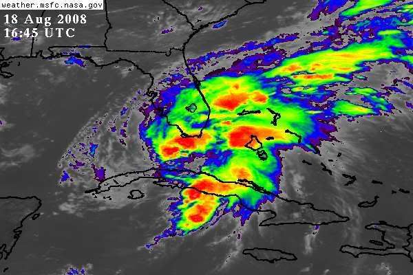
NEXRAD wrote:With the Florida Keys surface observations, notice the steeper pressure drops, this is a clear sign that the locations are falling within the tropical cyclone's core region.
- Jay

Blown_away wrote:deltadog03 wrote:
EURO has a very potent CANE sitting off the GA coast and coming in on thursday!
Deltadog03, will you confirm a few things:
1. Did recent recon indicate N movement?
2. With regards to the NHC track is this N movement early?
3. Do you expect more of an E adjustment to the NHC track?
4. Do you think Fay will exit into the Atlantic S of the Cape?
Sorry posted in the Fay models aslo.
tolakram wrote:
and once again the hi res floater link:
http://hadar.cira.colostate.edu/ramsdis ... ive_0.html
According to radar, the Keys are currently getting hard with strong banding. The apparent surface center is still well to the SSW halfway to Cuba, and echoes there are actually weakening.NEXRAD wrote:With the Florida Keys surface observations, notice the steeper pressure drops, this is a clear sign that the locations are falling within the tropical cyclone's core region.

tolakram wrote:
and once again the hi res floater link:
http://hadar.cira.colostate.edu/ramsdis ... ive_0.html

artist wrote:NEXRAD wrote:wxwonder12 wrote:Is the northward motion happening in the expected time frame or is it earlier then expected
I wouldn't consider a single fix to be a northward motion. Fay's past movement shows plenty of sudden changes with direction (more west versus more north) and with forward motion. I'd wait to see what the trend is over several hours.
- Jay
Jay, we are 30 miles to the east of the lake O. Do you think we will see anything more than ts winds here? Thanks!

Extremeweatherguy wrote:tolakram wrote:
and once again the hi res floater link:
http://hadar.cira.colostate.edu/ramsdis ... ive_0.html
Looking at those surface wind reports out of the keys, it seems like the center may have relocated ENE of the red circle and more toward the deeper convection.


Evil Jeremy wrote:lbvbl wrote:Anyone have any ideas about what PBC schools will be doing?
So far, they are open tomorrow, though there is speculation that they might have a half day tomorrow. It is not to late for minor changes like those.
Users browsing this forum: No registered users and 23 guests