ATL: Tropical Depression Fay
Moderator: S2k Moderators
-
JtSmarts

- S2K Supporter

- Posts: 1442
- Age: 40
- Joined: Thu Jul 10, 2003 1:29 pm
- Location: Columbia, South Carolina
Re: Mods...have we hit a new record yet?
Hi I am JtSmarts, and I have been addicted to Storm2k for five years. 

0 likes

Re: ATL: Tropical Storm Fay in Florida Straits
That tight compact core is what you don't want to see if you are trying to avoid fast intensification. I'm afraid this one is coming right at us on NHC track.
0 likes

Yeah exactly any westerly motion is obviously related to the ULL easing off and the convection building westwards and SW at long last rather then being displaced like it was about 12hrs ago.
Gatorcane, it looks very impressive right now, that looksl ike a CDO to me and I bet its starting to look good on microwave imagery now, cat-1 still looking more than possible.
Gatorcane, it looks very impressive right now, that looksl ike a CDO to me and I bet its starting to look good on microwave imagery now, cat-1 still looking more than possible.
0 likes
-
MusicCityMan

- Category 1

- Posts: 483
- Joined: Sat Feb 17, 2007 10:57 pm
- Location: Somewhere in Central Florida
-
JtSmarts
- S2K Supporter
- Posts: 1442
- Age: 40
- Joined: Thu Jul 10, 2003 1:29 pm
- Location: Columbia, South Carolina
Re: ATL: Tropical Storm Fay in Florida Straits
So unless it slows down again, we should expect landfall VERY early in the morning???
Last edited by JtSmarts on Mon Aug 18, 2008 2:38 pm, edited 1 time in total.
0 likes
-
cycloneye

- Admin

- Posts: 149369
- Age: 69
- Joined: Thu Oct 10, 2002 10:54 am
- Location: San Juan, Puerto Rico
Re: ATL: Tropical Storm Fay in Florida Straits
000
WTNT61 KNHC 181918
TCUAT1
TROPICAL STORM FAY TROPICAL CYCLONE UPDATE
NWS TPC/NATIONAL HURRICANE CENTER MIAMI FL AL062008
320 PM EDT MON AUG 18 2008
THE CENTER OF TROPICAL STORM FAY MADE LANDFALL OVER KEY WEST FLORIDA
AT 3 PM EDT.
$$
FORECASTER BEVEN/PASCH
http://www.nhc.noaa.gov/text/refresh/MI ... 1918.shtml
0 likes
-
tolakram
- Admin
- Posts: 20184
- Age: 62
- Joined: Sun Aug 27, 2006 8:23 pm
- Location: Florence, KY (name is Mark)
Re: ATL: Tropical Storm Fay in Florida Straits
http://mycampage.com/keywestcam
I'm wondering if this image is delayed. I now see calm winds and while it was bright it's getting darker quickly.
This image from near landfall.

I'm wondering if this image is delayed. I now see calm winds and while it was bright it's getting darker quickly.
This image from near landfall.
Last edited by tolakram on Mon Aug 18, 2008 2:41 pm, edited 1 time in total.
0 likes
Re: ATL: Tropical Storm Fay in Florida Straits
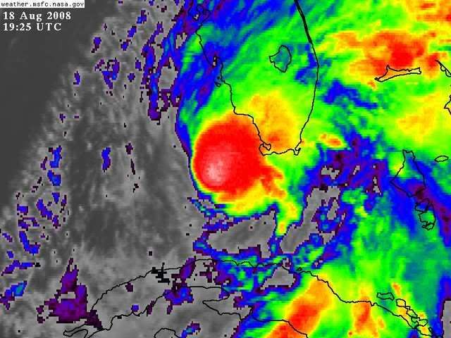
On IRWV you can notice deepening convection just northwest of Fay's center, and this core convective cluster seems to have a better satellite presentation, overall. Outflow continues to look reasonably good north of the storm and has shown some slight improvements towards the northwest. Furthermore, some new cells are starting to fire to the SE of the core cluster. From these observations, I'm thinking Fay will intensify a little during the next 6-hours.
- Jay
- Jay
0 likes

-
johngaltfla

- Category 5

- Posts: 2073
- Joined: Sun Jul 10, 2005 9:17 pm
- Location: Sarasota County, FL
- Contact:
Re: ATL: Tropical Storm Fay in Florida Straits
Looks like a 345-350 movement still in every loop, radar or sat that I see still. But she's definitely winding up. Once she clears the dry air, youch.
0 likes
-
MiamiensisWx
Based on the current movement per EYW (Key West) radar and satellite data, landfall may occur as early as tonight in the vicinity of Naples, Florida. Movement appears to be nearly due north, with hints of a slight, intermittent west component (NNW?).
http://www.ssd.noaa.gov/goes/flt/t1/loop-vis.html
I believe marginal Category 1 status (65 kt/75 mph) is very attainable, though those winds and the majority of the moderate/strong TS winds would be concentrated within a small area near the core (along the SW Florida coastline).
http://www.ssd.noaa.gov/goes/flt/t1/loop-vis.html
I believe marginal Category 1 status (65 kt/75 mph) is very attainable, though those winds and the majority of the moderate/strong TS winds would be concentrated within a small area near the core (along the SW Florida coastline).
Last edited by MiamiensisWx on Mon Aug 18, 2008 2:47 pm, edited 1 time in total.
0 likes

-
tolakram
- Admin
- Posts: 20184
- Age: 62
- Joined: Sun Aug 27, 2006 8:23 pm
- Location: Florence, KY (name is Mark)
Re: ATL: Tropical Storm Fay in Florida Straits
Ok, I know I said this was an illusion but boy does it look to be moving northwest or west.
0 likes
-
CourierPR
- Category 5
- Posts: 1336
- Age: 72
- Joined: Tue Aug 31, 2004 7:53 pm
- Location: Pompano Beach, Florida
Re: ATL: Tropical Storm Fay in Florida Straits
Local 10 Met. Trent Aric said at last update that Fay is slowing forward speed.
0 likes
-
deltadog03

- Professional-Met

- Posts: 3580
- Joined: Tue Jul 05, 2005 6:16 pm
- Location: Macon, GA
-
JonathanBelles
- Professional-Met
- Posts: 11430
- Age: 35
- Joined: Sat Dec 24, 2005 9:00 pm
- Location: School: Florida State University (Tallahassee, FL) Home: St. Petersburg, Florida
- Contact:
Who is online
Users browsing this forum: No registered users and 30 guests