Extremeweatherguy wrote:Recon finds central pressure of 998mb.
Seems to be organizing.
Moderator: S2k Moderators


Thunder44 wrote:Mike Seidel on TWC just said that they don't think it will intensify to hurricane. Now I'm worried.


Tampa Bay Hurricane wrote:***
Personal Forecast Disclaimer:
The posts in this forum are NOT official forecast and should not be used as such. They are just the opinion of the poster and may or may not be backed by sound meteorological data. They are NOT endorsed by any professional institution or storm2k.org. For official information, please refer to the NHC and NWS products.
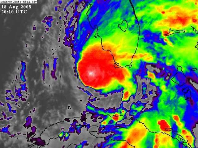
This looks like a 75 mph hurricane on satellite posted on the previous pages,
and it looks like with a very tight core of very intense convection
that intensification is occuring at a fast rate. The trough may be
venting this system and aiding intensification. Sea surface temperatures
and oceanic heat content also support fast intensification. This looks very
similar to the tightening, intensification, and trough venting that occurred
with Hurricane Charley. This could easily reach category 2 especially
if landfall is Fort Myers northward, or at least north of Naples.


DESTRUCTION5 wrote:She's stalled again...No question about it..Reorginizing just like she did below Cuba..

I am going to have to respectfully disagree. I still see a steady north motion on radar.DESTRUCTION5 wrote:She's stalled again...No question about it..Reorginizing just like she did below Cuba..
BigA wrote:Could someone post a link to one of the rapidly updating visible loops? I would be most appreciative.


Extremeweatherguy wrote:Recon finds central pressure of 998mb.

Users browsing this forum: No registered users and 20 guests