To counter claims that Fay is merely a "weak" tropical storm, here are some storm reports from NWSFO Key West...
11:14AM, 6mi SW Marathon - 59 mph gust, C-MAN station
12:31PM, 6mi SW Marathon - 62 mph gust, C-MAN station
12:49PM, 10mi SW Key West - 52 mph gust, C-MAN station
1:00PM, Long Key - 55 mph gust, Public report
1:00PM, Big Coppitt Key, Tornado - Monroe Co. Sheriffs
1:33PM, 6mi SSW Marathon - 63 mph gust, C-MAN station
1:45 PM, 10mi SW Key West - 71 mph gust, C-MAN station
2:40 PM, Islamorada - 60 mph gust, Fire Dept.
- Jay
ATL: Tropical Depression Fay
Moderator: S2k Moderators


Re: ATL: Tropical Storm Fay South of FT Myers
Winds finally picked up, took a video, going to post it soon.
0 likes
-
Evil Jeremy

- S2K Supporter

- Posts: 5463
- Age: 32
- Joined: Mon Apr 10, 2006 2:10 pm
- Location: Los Angeles, CA
Re:
gatorcane wrote:looks like an ESE drift?
NNE to me, but I think that this has a eastward component at this point.
0 likes


Re: ATL: Tropical Storm Fay in Florida Straits
TCmet wrote:
The windfield where potential hurricane scale impacts might be felt extends well away from the center. the cone only tracks the probability of the center passing over a given point. thus, warnings can be justified for a location outside the cone.
thanks TCMet I bet you those that are not in the cone are not looking at their warnings for the most part since they come from the local mets. Since following hurricanes I have never seen this before. Did it just start? As well as leaving off the forecast of 65 knts simply because it did not hit a forecast point in time. That to me is for the birds.
0 likes
Re: ATL: Tropical Storm Fay South of FT Myers
The cells offshore North Miami Dade / Broward County are showing signs of rotation and stronger wind gusts. They'll move onshore Broward County during the next hour.
- Jay
- Jay
0 likes
-
MGC

- S2K Supporter
- Posts: 5940
- Joined: Sun Mar 23, 2003 9:05 pm
- Location: Pass Christian MS, or what is left.
Re: ATL: Tropical Storm Fay South of FT Myers
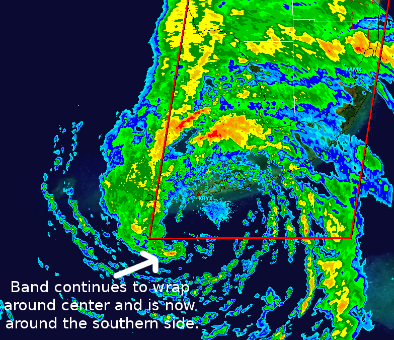
Sure does look like Fay is doing the Duval crawl as per radar Fay don't look to be moving. Fay is getting better organized as convection is starting to wrap around the circulation center. Fay has a good shot at reaching hurricane intensity later tonight. Should be a windy time along the Florida west coast. Should be some excellent shelling on Sanibel later in the week.....MGC
0 likes
Re: ATL: Tropical Storm Fay South of FT Myers
Jay - Do you think this slowing/stall we are seeing with Fay is what was predicted earlier today with the Euro that basically had the storm still sitting over KYW for about 24 hours?
0 likes
-
oyster_reef

- Tropical Storm

- Posts: 123
- Joined: Tue Aug 14, 2007 3:05 pm
- Location: Alabama
Re:
mattpetre wrote:It sure is getting great outflow to the NE now and apparently almost no shear over the center.
I think thats Sheer effect.
0 likes

-
Noles2006

- Category 1

- Posts: 424
- Joined: Thu Jun 08, 2006 9:57 am
- Location: Tallahassee, Florida
- Contact:
Re: ATL: Tropical Storm Fay South of Fort Myers
Question for the board: If it does stall for 12-24 hours... how would that change the long-term picture? With several models now forecasting a left-hand turn in about 72 hours, would that change anything?
0 likes
BULLETIN - EAS ACTIVATION REQUESTED
TORNADO WARNING
NATIONAL WEATHER SERVICE MIAMI FL
523 PM EDT MON AUG 18 2008
THE NATIONAL WEATHER SERVICE IN MIAMI HAS ISSUED A
* TORNADO WARNING FOR...
SOUTHEASTERN PALM BEACH COUNTY IN SOUTH FLORIDA.
* UNTIL 545 PM EDT
* AT 521 PM EDT...NATIONAL WEATHER SERVICE DOPPLER RADAR INDICATED A
THUNDERSTORM CAPABLE OF PRODUCING A TORNADO NEAR BOCA RATON...MOVING
NORTHWEST AT 35 MPH.
* THE TORNADO WILL BE NEAR...
LOXAHATCHEE NATIONAL WILDLIFE REFUGE...
AND SURROUNDING COMMUNITIES.
0 likes
-
Evil Jeremy
- S2K Supporter
- Posts: 5463
- Age: 32
- Joined: Mon Apr 10, 2006 2:10 pm
- Location: Los Angeles, CA
-
Pearl River

- S2K Supporter
- Posts: 825
- Age: 67
- Joined: Fri Dec 09, 2005 6:07 pm
- Location: SELa
Re: ATL: Tropical Storm Fay South of Fort Myers
From the 5:00pm Disco:
THE INITIAL MOTION IS 340/10. FAY IS ENTERING A BREAK IN THE
SUBTROPICAL RIDGE OVER THE EASTERN GULF OF MEXICO AND FLORIDA
CAUSED BY A MID/UPPER-LEVEL TROUGH MOVING THROUGH THE SOUTHEASTERN
UNITED STATES. BEYOND 36-48 HR...THE TROUGH IS FORECAST TO LIFT
OUT...WITH A MID/UPPER-LEVEL RIDGE BUILDING OVER THE EASTERN UNITED
STATES AHEAD OF A SECOND TROUGH OVER THE WESTERN GULF COAST STATES.
THE MODEL GUIDANCE STILL SHOWS CONSIDERABLE SPREAD IN RESPONDING TO
THIS PATTERN. THE NOGAPS CONTINUES TO CALL FOR A NORTH-
NORTHWESTWARD MOTION TOWARD THE FLORIDA PANHANDLE AND INLAND
THEREAFTER. THE UKMET HAS SHIFTED A LITTLE TO THE EAST AND
FORECASTS A NORTHWARD MOTION THROUGH THE FLORIDA PENINSULA...WITH A
SHARP TURN TO THE WEST AFTER 72 HR. THE CANADIAN MODEL HAS A
SIMILAR FORECAST. THE GFS AND ECMWF CALL FOR FAY TO TURN
NORTHEASTWARD INTO THE ATLANTIC...FOLLOWED BY A WESTWARD TURN AND
MOTION BACK INTO NORTHERN FLORIDA AFTER 72 HR. FINALLY...THE GFDL
AND THE HWRF CONTINUE FOR A GENERALLY NORTHWARD MOTION WELL INLAND
OVER THE EASTERN UNITED STATES. GIVEN THE INCREASING SIGNAL FROM
THE GLOBAL MODELS THAT NEW RIDGE TO THE NORTH WILL BLOCK FAY'S
PROGRESS...THE NEW FORECAST TRACK CALLS FOR A SLOWER AND MORE
WESTWARD MOTION AFTER 72 HR. THE EARLIER PART OF THE TRACK...WHICH
CALLS FOR LANDFALL IN SOUTHWESTERN FLORIDA IN ABOUT 18 HR FOLLOWED
BY A TRACK OVER THE FLORIDA PENINSULA...IS SHIFTED A LITTLE TO THE
EAST AND LIES NEAR THE MODEL CONSENSUS.
0 likes
Another Tornado warning out I see.
In terms of movement, the GFS runs have been showing it heading NW then really slowing down, indeed I really remember the 06z GFS run only getting this inland in about 30-36hrs, which if it occurs would suggest it still has a good 12-18hrs over water. Whilst I think thats overdoing it given the way the system seems to have slowed down thanks to the weaker steering currents its certainly not out of the question.
Also obviously slower motion would give it a little more time which would obviously increase the chances of this being a hurricane.
0 likes
Who is online
Users browsing this forum: No registered users and 23 guests