ATL: IKE Discussion
Moderator: S2k Moderators
-
attallaman
Re: ATL IKE: Category 2 - Discussion
What kind of weather, if any, can I expect to receive from Ike as he passes south of my location headed for Texas? Any feeder band activity? Squalls? Rain? Or just winds below tropical storm status? It's sunny here in Biloxi this morning and breezy.
0 likes


Re: Re:
Nederlander wrote:
listen to the promets... Derek stated that this could instensify to cat 4 rather quickly once the core gets it act together
Yeah but not with one outer eyewall replacing the other as soon as the other contracts, I've got a sneaky feeling that Ike isn't actually going to change its presentation all that much, given how hard it was to rid the last inner eyewall this one may take just as long and thats assuming another outer eyewall doesn't decide to form, which given the multiple wind Maxia is quite possible!
0 likes

-
jasons2k

- Storm2k Executive

- Posts: 8290
- Age: 52
- Joined: Wed Jul 06, 2005 12:32 pm
- Location: The Woodlands, TX
Re:
Frank2 wrote:fox13weather,
This is a public weather site for weather enthusiasts, so, each poster is entitled to his or her opinion - just as the media folks who continue their banter over topics that mean little to the public, but, they do it anyway, for the sake of ratings...
Frank
Then use the disclaimer because your "guess" does not match-up to anything scientific.
And yes, this is getting to be serious, so we need to be very careful what is posted. Thank you.
0 likes
-
carversteve

- Tropical Storm

- Posts: 161
- Joined: Sat Aug 18, 2007 7:40 am
Re: ATL IKE: Category 2 - Discussion
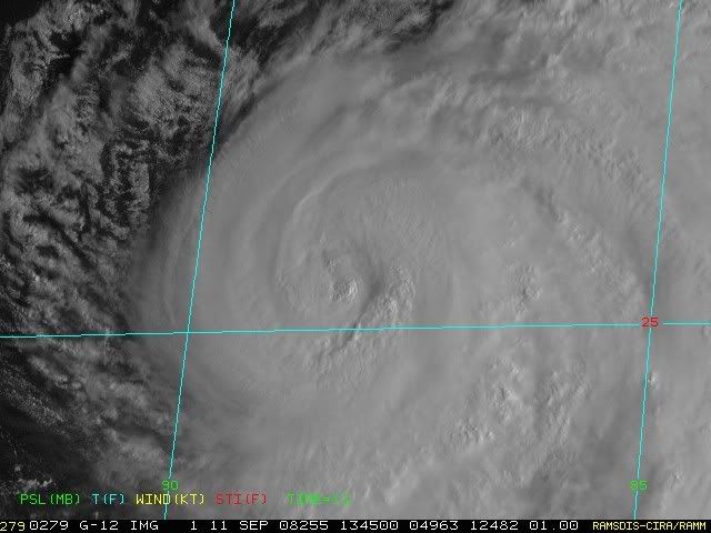
I'm no expert,but Ike seems to be tightening up a bit..and the one eye better defined..Is this correct or am i way off?
0 likes
-
THead
- S2K Supporter

- Posts: 790
- Joined: Mon Aug 30, 2004 5:09 pm
- Location: Lauderhill, Fla./Jefferson, Ga.
Re: Re:
Nederlander wrote:Frank2 wrote:I'd also have to agree with the poster who said that since the system hasn't intensified up to now, it's likely not to as it gets closer to land, since more dry hot air is being pulled into the system...
Just looking at the west side of Ike should answer any doubts about whether any dry is air present - there is...
listen to the promets... Derek stated that this could instensify to cat 4 rather quickly once the core gets it act together
NHCs latest intensity forecast, taken from the 5am Discussion
FORECAST POSITIONS AND MAX WINDS
INITIAL 11/0900Z 25.2N 87.6W 85 KT
12HR VT 11/1800Z 25.7N 89.0W 90 KT
24HR VT 12/0600Z 26.3N 91.0W 95 KT
36HR VT 12/1800Z 27.1N 93.2W 105 KT
48HR VT 13/0600Z 28.4N 95.2W 110 KT
72HR VT 14/0600Z 32.5N 96.0W 40 KT...INLAND
Just sayin, they still believe he's going to come around to major cane status too.
0 likes

The other thing to note is Ike is a huge system, even if it holds where it is now (which I think is unlikely, it is very slowly winding up depsite the eyewall structure) its still going to cause huge damage to the Texas coastline and probably western LA as well, Houston and Galveston may well get hammered by Ike even if it makes landfall a little down the coast.
0 likes

Re: Re:
KWT wrote:Nederlander wrote:
listen to the promets... Derek stated that this could instensify to cat 4 rather quickly once the core gets it act together
Yeah but not with one outer eyewall replacing the other as soon as the other contracts, I've got a sneaky feeling that Ike isn't actually going to change its presentation all that much, given how hard it was to rid the last inner eyewall this one may take just as long and thats assuming another outer eyewall doesn't decide to form, which given the multiple wind Maxia is quite possible!
KWT,
Is there any way to provide a graphic that shows the 2 eye walls? I'd like to know what everone is seeing!
Thanks
0 likes

-
Hurricanewatcher2007

- Category 2

- Posts: 578
- Joined: Sat Jul 05, 2008 8:10 pm
Re: Re:
KWT wrote:Nederlander wrote:
listen to the promets... Derek stated that this could instensify to cat 4 rather quickly once the core gets it act together
Yeah but not with one outer eyewall replacing the other as soon as the other contracts, I've got a sneaky feeling that Ike isn't actually going to change its presentation all that much, given how hard it was to rid the last inner eyewall this one may take just as long and thats assuming another outer eyewall doesn't decide to form, which given the multiple wind Maxia is quite possible!
The outer wind maxima is from the the outer eye-wall which should still be contracting. there are still concentric eye-walls based on the last VDM from a couple hours ago. so the EWRC hasn't finished yet. By the time the EWRC is finished there shouldn't be a double wind maxima any more.
0 likes
-
Derek Ortt
Re:
Frank2 wrote:I'd also have to agree with the poster who said that since the system hasn't intensified up to now, it's likely not to as it gets closer to land, since more dry hot air is being pulled into the system...
Just looking at the west side of Ike should answer any doubts about whether any dry is air present - there is...
Huh?
0 likes
-
mattpetre
- Category 2
- Posts: 510
- Age: 54
- Joined: Mon Sep 19, 2005 3:20 pm
- Location: Missouri City,TX & Galleria
- Contact:
Re: ATL IKE: Category 2 - Discussion
fox13weather wrote:Geeee, everyone is entitled their opinion, but the number of posts from people here that are stating "facts" about a complex science when they have absolutely no qualifications to do so is alarming. As a pro met, I would not be wandering over to a board devoted to cancer and come up with "absolutes" on cancer treatment methods. If I had the time I would go back and correct each post, but I do not. In the meantime, it is irresponsible to do satellite, recon, and model analysis based on an earth science class some of you may have taken in the 7th grade.
What about Ike?
0 likes

Re: ATL IKE: Category 2 - Discussion
UPDATE...water is touching HWY 90 in Biloxi per my sister, and the garage of Hard Rock is flooding.
0 likes
-
Hurricanewatcher2007
- Category 2
- Posts: 578
- Joined: Sat Jul 05, 2008 8:10 pm
Re: Re:
Aristotle wrote:KWT wrote:Nederlander wrote:
listen to the promets... Derek stated that this could instensify to cat 4 rather quickly once the core gets it act together
Yeah but not with one outer eyewall replacing the other as soon as the other contracts, I've got a sneaky feeling that Ike isn't actually going to change its presentation all that much, given how hard it was to rid the last inner eyewall this one may take just as long and thats assuming another outer eyewall doesn't decide to form, which given the multiple wind Maxia is quite possible!
KWT,
Is there any way to provide a graphic that shows the 2 eye walls? I'd like to know what everone is seeing!
Thanks
this is the latest microwave pass we have. It didn't catch the full circulation but you can still see the double eye-walls

0 likes
-
fox13weather
- Professional-Met

- Posts: 161
- Joined: Tue Sep 20, 2005 7:49 pm
Re:
Frank2 wrote:fox13weather,
This is a public weather site for weather enthusiasts, so, each poster is entitled to his or her opinion - just as the media folks who continue their banter over topics that mean little to the public, but, they do it anyway, for the sake of ratings...
Frank
You are so wrong. People with zero meteorology background should not be posting "absolutes or facts" when they are doing more than taking wild stabs.. Opinions are one thing, pretending that people know what they are talking about is another thing. Media folks are entitled to their opinions on a wide range of subjects, but when it comes to analyzing and predicting a hurricane then they have no right. When was the last time you have seen an anchor talk openly about upper level diffluenceeven if said anchor was a weather "enthusiast, i.e. hobby".
What is the difference between some unqualified poster analyzing a water vapor image and you or I analyzing an MRI picture?? answer that!
Last edited by fox13weather on Thu Sep 11, 2008 8:58 am, edited 2 times in total.
0 likes
Re: ATL IKE: Category 2 - Discussion
I think the fact that interest in Ike this morning seems to be modest at best is a dangerous testament to how "break all records or who cares" this board has become. When was the last time you remember a major metropolitan area being blanketed by sustained category 2 winds (as Houston might be)? Andrew got a PORTION of the Miami metro area, but a lot of it got TS winds/marginal cat 1 since he was so small). I think you have to go all the way back to Hurricane Hugo and what it gave Charleston. You're going to see a tremendous storm surge from this - the only hurricane with such a largely comparable swatch of cat 2 hurricane force winds we have to compare Ike to is Katrina, and we all remember what that did to the Mississippi Gulf Coast.
Bottom line: if Ike comes in as predicted, I think total damage totals will rival Andrew just from the sheer expanse of destruction that will ensue, even if no one area gets obliterated like Homestead did.
Bottom line: if Ike comes in as predicted, I think total damage totals will rival Andrew just from the sheer expanse of destruction that will ensue, even if no one area gets obliterated like Homestead did.
0 likes
-
keithy joe

- Tropical Low

- Posts: 22
- Age: 43
- Joined: Wed Sep 10, 2008 11:46 am
- Location: England - UK (Plymouth)
- Contact:
Re: Re:
Derek Ortt wrote:Frank2 wrote:I'd also have to agree with the poster who said that since the system hasn't intensified up to now, it's likely not to as it gets closer to land, since more dry hot air is being pulled into the system...
Just looking at the west side of Ike should answer any doubts about whether any dry is air present - there is...
Huh?
I disagree Frank, entirely. I think IKE will intensify to a CAT3 at least with potential for brief CAT4 although this very much dependant on the eye-wall interface sorting itself out.
0 likes
Who is online
Users browsing this forum: No registered users and 19 guests