ATL: Tropical Depression Fay
Moderator: S2k Moderators
-
mf_dolphin

- Category 5

- Posts: 17758
- Age: 69
- Joined: Tue Oct 08, 2002 2:05 pm
- Location: St Petersburg, FL
- Contact:
-
Scorpion

Re:
HurricaneHunter914 wrote:http://radar.weather.gov/ridge/radar.php?rid=BYX&product=NCR&overlay=11101111&loop=yes
A ragged eye does seem to be forming. I seriously think they'll find hurricane force winds in the NE quad, now that I've seen that radar loop.
Here's a radar loop that one of the mets posted today. Nice view of the deep solid band forming to the north.
http://weather.cod.edu/analysis/paulradar.pl?BYX
Load and hit loop.
0 likes

-
storms in NC

- S2K Supporter

- Posts: 2338
- Joined: Thu Jul 28, 2005 2:58 pm
- Location: Wallace,NC 40 miles NE of Wilm
- Contact:
Re:
txwatcher91 wrote:Here is what our local weather office says about Fay and potential impact of the trough and hp.
In the wake of a sharp upper-level trough that sweeps through
southeast Canada and northern New England early in the week...the
long-term guidance is suggestive of a building upper-level ridge
over the northeast and mid-Atlantic. One concern is that the
forecast strengthening of the ridge is too great...which on some
guidance forces Fay back across Florida and into the Gulf over
time. Based on a current forecast of the ridge strengthening but
not as much as the GFS and the dgex...the track of Fay and its
remnants follow a slight turn to the northwest over time as they
approach the state.
This is a shame that we will not get any rain from Fay it would have helped with the very very bad drought we are having here in NC.
But I have never thought Fay would come up this far.
Well I am done till early in the AM. I have to see how my Kids are doing with Fay then.
Good Night all and Be safe
Deb
0 likes
-
gtalum

- S2K Supporter
- Posts: 4749
- Age: 50
- Joined: Tue Sep 07, 2004 3:48 pm
- Location: Bradenton, FL
- Contact:
Re:
HURAKAN wrote:Getting prepare is the right thing to do. If nothing happens, you didn't lose anything except a little time. Is better to prepare for nothing than not to prepare and something happens.
I'm fully prepared for Fay.
Time is a valuable commodity and I'm glad I didn't waste any putting my shutters up (and then of course taking them down in a couple of days).
0 likes
Re: ATL: Tropical Storm Fay South of Naples
You can see the ULL punched right into Fay on the SE side. No chance on intensification in that case. All that talk about perfect overhead conditions and moving away from the ULL was wrong.
0 likes
-
johngaltfla

- Category 5
- Posts: 2073
- Joined: Sun Jul 10, 2005 9:17 pm
- Location: Sarasota County, FL
- Contact:
Re: Re:
fact789 wrote:HURAKAN wrote:gtalum wrote:All this worry for nothing. I'm glad I didn't shutter up.
Getting prepare is the right thing to do. If nothing happens, you didn't lose anything except a little time. Is better to prepare for nothing than not to prepare and something happens.
I put boards up on the weaker windows just in case. Theyre staying up till Novemeber now!
I just about did that. Then thought, nah, we'll just stage it.
Then again, I'm not trusting the forecasting as much as I used to either. Maybe I'll just leave it in the garage until November....
0 likes
-
Extratropical1
- Tropical Low

- Posts: 45
- Joined: Fri Jun 13, 2008 10:14 am
- Location: Spring Hill, Florida
Re: ATL: Tropical Storm Fay South of Naples
Way too much dry air for any intensification. Time after time the NHC overlooks the power of dry air
0 likes
-
Weatherboy1

- Category 5
- Posts: 1190
- Age: 50
- Joined: Mon Jul 05, 2004 1:50 pm
- Location: Jupiter/Sarasota, FL
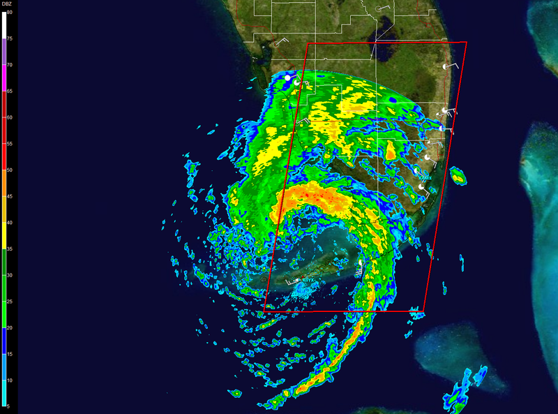
Sure looks like an "eye" may be clearing out for Fay in the last few radar images from this loop:
http://radar.weather.gov/radar.php?rid= ... 1&loop=yes
I wouldn't be surprised one bit to see this thing make landfall around Everglades City or just slightly west, and to do so as a minimal hurricane.
http://radar.weather.gov/radar.php?rid= ... 1&loop=yes
I wouldn't be surprised one bit to see this thing make landfall around Everglades City or just slightly west, and to do so as a minimal hurricane.
0 likes


Re: ATL: Tropical Storm Fay South of Naples
Extratropical1 wrote:Way too much dry air for any intensification. Time after time the NHC overlooks the power of dry air
I didn't know the NHC is forecasting a category 3 at landfall.
0 likes
-
Terry
- S2K Supporter
- Posts: 1450
- Joined: Wed Aug 11, 2004 8:25 pm
- Location: Lakeland and Anna Maria Island, FL
- Contact:
Re:
RL3AO wrote:I can't wait until Senorpepr does the verification of Fay and shows how amazing the NHC forecasted this storm, especially considering the land interaction, the parallel approach to Florida, and the constant shift of the models run to run.
THIS does a good job of showing how well they did.
0 likes
-
gtalum
- S2K Supporter
- Posts: 4749
- Age: 50
- Joined: Tue Sep 07, 2004 3:48 pm
- Location: Bradenton, FL
- Contact:
Re: ATL: Tropical Storm Fay South of Naples
Extratropical1 wrote:Way too much dry air for any intensification. Time after time the NHC overlooks the power of dry air
I'm not sure what you're gettign at. NHC has been predicting a minimal cat 1 hurricane at most.
0 likes
-
gatorcane

- S2K Supporter
- Posts: 23708
- Age: 48
- Joined: Sun Mar 13, 2005 3:54 pm
- Location: Boca Raton, FL
The posts in this forum are NOT official forecast and should not be used as such. They are just the opinion of the poster and may or may not be backed by sound meteorological data. They are NOT endorsed by any professional institution or storm2k.org. For official information, please refer to the NHC and NWS products
looks to me like its still intensifying and heading NNE now. It's about as far West as it is going to get. I still think it will past E of Ft. Myers and Naples.
0 likes

Re:
Bgator wrote:Anyone have any thoughts on that band in marathon right now?
The band over Marathon, extreme Srn Miami-Dade Co., and Monroe is accompanied by sustained 35 to 45 mph surface winds along with gusts of 50 to 60 mph, per recent surface reports.
- Jay
0 likes
-
Extratropical1
- Tropical Low
- Posts: 45
- Joined: Fri Jun 13, 2008 10:14 am
- Location: Spring Hill, Florida
Re: ATL: Tropical Storm Fay South of Naples
sorry I have two windows open and thought I was posting to another
0 likes
Who is online
Users browsing this forum: No registered users and 18 guests