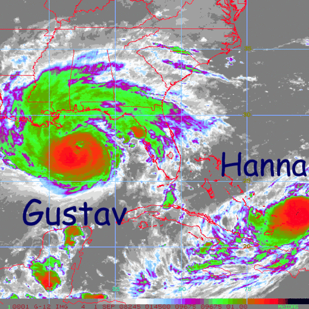
We could be going into a weakening phase here. The cloud tops are warming quite a bit. Reds are dissapearing and the dry slot seems to be holding. It's probably starting to feel the effects of the colder waters.
http://www.ssd.noaa.gov/goes/flt/t1/avn-l.jpg
ATL GUSTAV: Tropical Depression - Discussion
Moderator: S2k Moderators
-
ConvergenceZone
.gif)
- Category 5

- Posts: 5241
- Joined: Fri Jul 29, 2005 1:40 am
- Location: Northern California
-
Just Joshing You

- Category 2

- Posts: 512
- Joined: Sat Nov 03, 2007 10:29 am
- Location: Nova Scotia
-
CYCLONE MIKE
- Category 5
- Posts: 2183
- Joined: Tue Aug 31, 2004 6:04 pm
- Location: Gonzales, LA
-
Stormcenter
- S2K Supporter

- Posts: 6685
- Joined: Wed Sep 03, 2003 11:27 am
- Location: Houston, TX
Re: Cat 3 Hurricane Gustav in Gulf of Mexico
A tropical storm's movement is in the eye of the beholder. I say NW to WNW maybe.
http://radar.weather.gov/radar.php?prod ... X&loop=yes
http://radar.weather.gov/radar.php?prod ... X&loop=yes
0 likes

Re: Cat 3 Hurricane Gustav in Gulf of Mexico
New vortex is out
955mb
MAX FL WIND 113KTS N QUAD 0158Z
MAX OUTBOUND FL WIND 108KTS NE QUAD 0211Z
955mb
MAX FL WIND 113KTS N QUAD 0158Z
MAX OUTBOUND FL WIND 108KTS NE QUAD 0211Z
0 likes
-
LAwxrgal

- S2K Supporter
- Posts: 1763
- Joined: Tue Jul 06, 2004 1:05 pm
- Location: Reserve, LA (30 mi west of NOLA)
Re: Cat 3 Hurricane Gustav in Gulf of Mexico
Hello all, LAwxrgal here signing on from Humble, TX. My heart is sick watching the radar loops and knowing what's about to happen to places I know well and hold dear, including my hometown. I've spent a lifetime with a love of storms, and developed a healthy fear and respect for them after Hurricane Katrina. Now I think it's about to turn to a full-on hate if G does what he's forecast to do.
Peace and prayers,
Danielle
Peace and prayers,
Danielle
0 likes
Re:
Just Joshing You wrote:I think it is weakening a little too late to landfall. Also, the windfield will just broaden more anyways.. so it doesn't really effect it all that much at the point of landfall.
Yeah.... that just means more of MS, LA, and AL will receive storm winds.
0 likes
-
Hyperstorm

- Category 5
- Posts: 1500
- Joined: Sun Sep 07, 2003 3:48 am
- Location: Ocala, FL
Re: Cat 3 Hurricane Gustav in Gulf of Mexico
Pressure is up slightly, so the system is steady state right now. That's what happens when you follow short term trends. You cannot just assume you will see a system explode in intensity when you see deep reds on satellite for an hour or two.
The system still may strengthen some to around 125 mph during the next 6 hours with another burst of convection, but after that it should level off and/or slowly weaken as it heads toward the coast with increasing shear. Landfall should be anywhere from 115-125 mph at the most.
God Bless everyone in its path.
0 likes
-
MHurricanes

- Tropical Storm

- Posts: 102
- Age: 73
- Joined: Thu Aug 14, 2008 2:05 pm
- Location: Altamonte Springs, FL
- Contact:
Re:
HURAKAN wrote:
Dangerous siblings.
Hurakan,
Thanks for all the great posts. I suppose I'm getting addicted to this great site.
I have suggested that many good people tend to romanticize hurricanes. Most of those folks have not experienced one -- or two or three. Which brings me to my point: It would be great to hear from a few people who have survived, or at least endured, Nature's thumb in the eye.
- MHurricanes
0 likes
-
ConvergenceZone
- Category 5
- Posts: 5241
- Joined: Fri Jul 29, 2005 1:40 am
- Location: Northern California
Re: Cat 3 Hurricane Gustav in Gulf of Mexico
Normandy wrote:Yep, convection is now consistently weakening... Good news, i thought earlier that Gustav might go nuts before landfall. Still, no need to downplay this....its gonna be awful.
Yep, you never want to downplay a hurricane, but based upon how fast I've seen some of the cold cloud tops warming and the dry air slot expanding north of the eye. I would say that it's possible this can be down to 95 mph or 100 mph at landfall. borderline cat1/cat2.....Now before you start cursing me, keep in mind that it only has to drop 15 to 20 mph from where it is currently, and that wouldn't be very hard for it to do considering it still has several more hours over water.
Just my opinion based on current trend.
0 likes
Re: Cat 3 Hurricane Gustav in Gulf of Mexico
Stormcenter wrote:A tropical storm's movement is in the eye of the beholder. I say NW to WNW maybe.
http://radar.weather.gov/radar.php?prod ... X&loop=yes
It's also relative to the radar you're using. It's going to look different from Baton Rouge than it does Mobile.
0 likes
-
RainWind
-
HarlequinBoy

- Category 5
- Posts: 1400
- Age: 35
- Joined: Wed Nov 29, 2006 1:57 am
- Location: Memphis
Re: Cat 3 Hurricane Gustav in Gulf of Mexico
ConvergenceZone wrote:Normandy wrote:Yep, convection is now consistently weakening... Good news, i thought earlier that Gustav might go nuts before landfall. Still, no need to downplay this....its gonna be awful.
Yep, you never want to downplay a hurricane, but based upon how fast I've seen some of the cold cloud tops warming and the dry air slot expanding north of the eye. I would say that it's possible this can be down to 95 mph or 100 mph at landfall. borderline cat1/cat2.....Now before you start cursing me, keep in mind that it only has to drop 15 to 20 mph from where it is currently, and that wouldn't be very hard for it to do considering it still has several more hours over water.
Just my opinion based on current trend.
That's true. Lili was stronger and it fell apart just like that. *snaps*
0 likes
-
captain east

- Tropical Storm
- Posts: 213
- Joined: Thu Aug 28, 2008 2:53 pm
- Location: South East Florida
Re:
RainWind wrote:Does anyone know where one could go to get current, live wind reports for the Baton Rouge area?
No idea..
BTW good luck, my prayers are with you...
0 likes
-
Hyperstorm
- Category 5
- Posts: 1500
- Joined: Sun Sep 07, 2003 3:48 am
- Location: Ocala, FL
Re: Cat 3 Hurricane Gustav in Gulf of Mexico
ConvergenceZone wrote:Normandy wrote:Yep, convection is now consistently weakening... Good news, i thought earlier that Gustav might go nuts before landfall. Still, no need to downplay this....its gonna be awful.
Yep, you never want to downplay a hurricane, but based upon how fast I've seen some of the cold cloud tops warming and the dry air slot expanding north of the eye. I would say that it's possible this can be down to 95 mph or 100 mph at landfall. borderline cat1/cat2.....Now before you start cursing me, keep in mind that it only has to drop 15 to 20 mph from where it is currently, and that wouldn't be very hard for it to do considering it still has several more hours over water.
Just my opinion based on current trend.
I would highly doubt that is the case. The system did in fact strengthen today with decreased shear. Based on aircraft data, it had been a Category 2 most of the day and FL winds now support a Category 3. So again, it did strengthen. The question is...Will this continue? IMO, it could as the structure looks the best it has all day, but don't expect a Category 4. The shear is still there. If the system slows down more than forecast, it could weaken as much as you say, but chances are low.
0 likes


Re: Cat 3 Hurricane Gustav in Gulf of Mexico
I just found out my daughter is sitting at home alone in Biloxi with my two grandsons age 1 and 7. She's near Pass Road and Keesler. I'm really worried. My son stayed in Biloxi too. I haven't heard from him yet. It's gonna be a long night.
0 likes
-
O Town
- S2K Supporter
- Posts: 5205
- Age: 52
- Joined: Wed Sep 07, 2005 9:37 pm
- Location: Orlando, Florida 28°35'35"N 81°22'55"W
Re:
RainWind wrote:Does anyone know where one could go to get current, live wind reports for the Baton Rouge area?
http://www.wunderground.com/weatherstat ... =KLABATON9
http://www.wunderground.com/weatherstat ... =KLABATON3
Look to the right at the map for the exact location, but both those are in Baton Rouge.
0 likes


Re: Cat 3 Hurricane Gustav in Gulf of Mexico
ConvergenceZone,
I actually think it has a better chance of becoming a Category 4 hurricane than weakening the a borderline 1 or 2. Steady state, possibly slight intensification before landfall. For sure a major though I think.
I actually think it has a better chance of becoming a Category 4 hurricane than weakening the a borderline 1 or 2. Steady state, possibly slight intensification before landfall. For sure a major though I think.
0 likes
Who is online
Users browsing this forum: No registered users and 25 guests