000
FXUS62 KMFL 060814
AFDMFL
AREA FORECAST DISCUSSION
NATIONAL WEATHER SERVICE MIAMI FL
414 AM EDT WED AUG 6 2008
.DISCUSSION...HIGH PRESSURE WILL REMAIN PARKED OVER CENTRAL
FLORIDA THROUGH WEDNESDAY WITH A EASTERLY 10 KNOT STEERING FLOW SO
EXPECT POPS TO BE HIGHEST (40-50%) OVER THE INTERIOR AND WEST
COASTAL AREAS NEXT 2 DAYS. STEERING FLOW SLOWS DOWN ON THURSDAY AS
THE RIDGE MOVES INTO SOUTH FLORIDA SO SEABREEZES AND OUTFLOWS WILL
DOMINATE WITH HIGHEST POPS IN THE INTERIOR. THEN ON FRIDAY, THE
RIDGE MOVES SOUTH INTO THE KEYS AND THE AREA WILL BE UNDER A SW-W
FLOW THROUGH EARLY NEXT WEEK WHICH MEANS THE HIGHEST POPS (50%)
WILL SHIFT TO THE EAST COAST. UNDER THIS FLOW, EXPECT LATE DAY
EAST COAST SEABREEZES AND THIS SHOULD PUSH THE MAX TEMPS INTO THE
LOWER TO MID 90S. RELATIVELY COOLER TEMPS CAN BE EXPECTED OVER THE
WEST COAST BUT STILL NEAR 90 FOR THE WEEKEND AND INTO THE EARLY
PART OF NEXT WEEK. AS THE RIDGE SITS OVER THE KEYS, A TROUGH OF
LOW PRESSURE IN THE MID LEVELS DEEPENS INTO THE EASTERN UNITED
STATES. THIS WILL PUSH A FRONTAL TROUGH INTO NORTH CENTRAL FLORIDA
BY LATE IN THE WEEKEND WHICH IS VERY UNUSUAL FOR THIS TIME OF
YEAR. THIS FRONTAL TROUGH WILL MOVE NORTH OF FLORIDA BY LATE
MONDAY. EXPECT THE CONTINUANCE OF HIGHEST POPS (CHANCE) INTERIOR
AND EAST FOR EARLY NEXT WEEK.
http://www.crh.noaa.gov/product.php?site=NWS&issuedby=MFL&product=AFD
Ex Invest 99L in Western Atlantic
Moderator: S2k Moderators
-
SapphireSea
- Category 1

- Posts: 430
- Joined: Wed Aug 24, 2005 12:13 pm
- Location: Miami, FL
-
Honeyko
Re: Ex Invest 99L in Western Atlantic
It doesn't appear likely, as steering winds at both surface and aloft have an easterly component. IMO, this will take a near-Rita track for the next 48hrs (i.e., through the straights).alan1961 wrote:IMO if this carries on convecting it could possibly do some stalling out over the lower Bahamas or slide down over cuba..any thoughts on this?
(And....I have to sign off for awhile now on account of extreme sleepiness.
-- Y'all make sure it don't get too out of control now, ya hear?)
0 likes


-
Matt-hurricanewatcher
Re: Ex Invest 99L in Western Atlantic
Looks like a little northly shear, but it should stay on a westly track for the next 24 hours or so. If it can start firing up new convection then that will be a big sign.
0 likes


Re: Ex Invest 99L in Western Atlantic
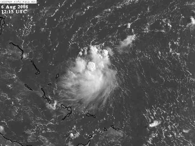
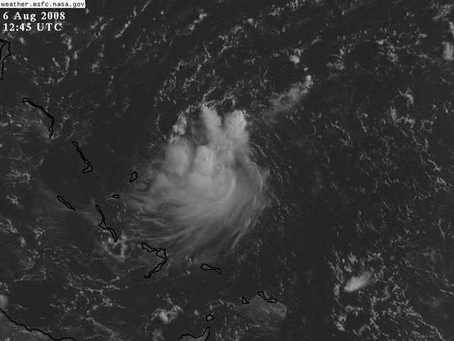
Cloud tops are warming and weren't that cold to begin with. Lets see if they refire soon.
0 likes


-
AJC3

- Admin

- Posts: 4153
- Age: 62
- Joined: Tue Aug 31, 2004 7:04 pm
- Location: Ballston Spa, New York
- Contact:
Re: Ex Invest 99L in Western Atlantic
I can't see this system making it across the FL straits. The low level vort center only has about 24 hours or so left where it's motion can continue on a slightly N of west track. After about 24 hours the narrow low to mid level ridge across Florida is forecast to break down, and be replaced by increasingly deep SW flow. I suspect this system may make a pretty close approach to the SE FL coast late tonight, but then slow down considerably before slowly turning NE away from FL.
0 likes
Re: Re:
Honeyko wrote:>shrug< I call it like I see it. I've seen sat pics of both. Hell, there's pics of both right in this thread, and anybody can do what I suggested themselves. Monica was also only in 2006, and I'd merely suspect nobody's bothered to sit down and deal with a comparison in any "official" record-changing capacity that, say, Wikipedia would consider "notable".Chacor wrote:Tracy is the smallest known recorded cyclone. Please provide proof of your claim for Monica; this is getting close to trolling.
Here you go. Hope that settles that.

0 likes
-
SapphireSea
- Category 1
- Posts: 430
- Joined: Wed Aug 24, 2005 12:13 pm
- Location: Miami, FL
Re: Ex Invest 99L in Western Atlantic
AJC3 wrote:I can't see this system making it across the FL straits. The low level vort center only has about 24 hours or so left where it's motion can continue on a slightly N of west track. After about 24 hours the narrow low to mid level ridge across Florida is forecast to break down, and be replaced by increasingly deep SW flow. I suspect this system may make a pretty close approach to the SE FL coast late tonight, but then slow down considerably before slowly turning NE away from FL.
This is likely. I have been monitoring this 'frontal trough' since it was mentioned in the AFD last week, and it looks like it may materialize. Indeed, this should be slowing down pretty soon, as steering gets fairly weak. Also this has no LLC, it still has a good while before it does attain one, and that may be too late before shear becomes an issue.
I really do hope that blob makes it here, I could definitely use a huge amount of rain.
0 likes
-
cycloneye

- Admin
- Posts: 149275
- Age: 69
- Joined: Thu Oct 10, 2002 10:54 am
- Location: San Juan, Puerto Rico
Re: Ex Invest 99L in Western Atlantic
NHC has no interest in ex 99L.
474
ABNT20 KNHC 061154
TWOAT
TROPICAL WEATHER OUTLOOK
NWS TPC/NATIONAL HURRICANE CENTER MIAMI FL
800 AM EDT WED AUG 6 2008
FOR THE NORTH ATLANTIC...CARIBBEAN SEA AND THE GULF OF MEXICO...
THE HYDROMETEOROLOGICAL PREDICTION CENTER IS ISSUING ADVISORIES ON
TROPICAL DEPRESSION EDOUARD...LOCATED INLAND OVER TEXAS ABOUT 30
MILES WEST-NORTHWEST OF WACO.
ELSEWHERE...TROPICAL CYCLONE FORMATION IS NOT EXPECTED DURING THE
NEXT 48 HOURS.
$$
FORECASTER KNABB
0 likes
-
Matt-hurricanewatcher
Re:
Chacor wrote:Quikscat does not show a low.
About 60% and that this is so small I would not expect the quickscat to be able to close it off. Also it is still moving pretty fast so that drowns out the west wind.
Anyways I don't believe its closed as of yet. But not far from it.
0 likes


Re: Ex Invest 99L in Western Atlantic
NHC is ignoring it:
Buoy 41046 showed 5 ft seas building to over 7 feet and they showed nothing....
Big difference between 4ft and 7 ft seas on the open water
http://www.nhc.noaa.gov/tafb_latest/atlsea_latestBW.gif
Buoy 41046 showed 5 ft seas building to over 7 feet and they showed nothing....
Big difference between 4ft and 7 ft seas on the open water
http://www.nhc.noaa.gov/tafb_latest/atlsea_latestBW.gif
0 likes
Re: Re:
drezee wrote:Chacor wrote:That buoy is reporting 15 kt SE winds.
that picture I linked was created at 0000UTC...check the obs then
Was similar at 00z, also 15 kt. I spot a 21kt ESE reading from 05 UTC.
0 likes

Re: Ex Invest 99L in Western Atlantic
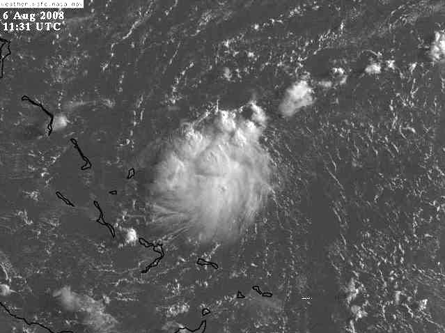
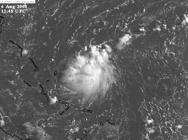
The clouds are now warming and if this makes it to S FL I'll be surprised because the steering flow will be nil tomorrow due to the ridge moving south to S FL.
http://metofis.rsmas.miami.edu/~dortt/s ... 1_loop.gif
http://metofis.rsmas.miami.edu/~dortt/s ... 1_loop.gif
0 likes
Who is online
Users browsing this forum: No registered users and 26 guests