EPAC : TROPICAL DEPRESSION RICK (20E)
Moderator: S2k Moderators
-
cycloneye

- Admin

- Posts: 149727
- Age: 69
- Joined: Thu Oct 10, 2002 10:54 am
- Location: San Juan, Puerto Rico
Re: EPAC : HURRICANE RICK (20E)
It will be very interesting to see the observations from the island of Socorro when it passes very close to it.
0 likes
Visit the Caribbean-Central America Weather Thread where you can find at first post web cams,radars
and observations from Caribbean basin members Click Here
and observations from Caribbean basin members Click Here

Re: EPAC : HURRICANE RICK (20E)
breeze wrote:Just curious - why is recon not going out right now? Are they waiting until a landfall becomes
imminent?
recon will not go out unless landfall is 24-48 hours and there is a potential impact on the southern weather patterns. There are many cards that have to be turned before a recon flight over mexico.
0 likes
-
srainhoutx

- S2K Supporter

- Posts: 6919
- Age: 68
- Joined: Sun Jan 14, 2007 11:34 am
- Location: Haywood County, NC
- Contact:
Re: EPAC : HURRICANE RICK (20E)
Thanks pojo. I have wondered if we could see tasking tomorrow.
0 likes
Carla/Alicia/Jerry(In The Eye)/Michelle/Charley/Ivan/Dennis/Katrina/Rita/Wilma/Ike/Harvey
Member: National Weather Association
Wx Infinity Forums
http://wxinfinity.com/index.php
Facebook.com/WeatherInfinity
Twitter @WeatherInfinity
Member: National Weather Association
Wx Infinity Forums
http://wxinfinity.com/index.php
Facebook.com/WeatherInfinity
Twitter @WeatherInfinity
Re: EPAC : HURRICANE RICK (20E)
srainhoutx wrote:Thanks pojo. I have wondered if we could see tasking tomorrow.
that is still a possibility, but it would be 18-24 hours after the tasking is issued before you would see a plane in the storm....
0 likes


-
srainhoutx
- S2K Supporter
- Posts: 6919
- Age: 68
- Joined: Sun Jan 14, 2007 11:34 am
- Location: Haywood County, NC
- Contact:
Re: EPAC : HURRICANE RICK (20E)
Ditto.

0 likes
Carla/Alicia/Jerry(In The Eye)/Michelle/Charley/Ivan/Dennis/Katrina/Rita/Wilma/Ike/Harvey
Member: National Weather Association
Wx Infinity Forums
http://wxinfinity.com/index.php
Facebook.com/WeatherInfinity
Twitter @WeatherInfinity
Member: National Weather Association
Wx Infinity Forums
http://wxinfinity.com/index.php
Facebook.com/WeatherInfinity
Twitter @WeatherInfinity
-
tolakram
- Admin
- Posts: 20186
- Age: 62
- Joined: Sun Aug 27, 2006 8:23 pm
- Location: Florence, KY (name is Mark)
Re: EPAC : HURRICANE RICK (20E)

0 likes
M a r k
- - - - -
Join us in chat: Storm2K Chatroom Invite. Android and IOS apps also available.
The posts in this forum are NOT official forecasts and should not be used as such. Posts are NOT endorsed by any professional institution or STORM2K.org. For official information and forecasts, please refer to NHC and NWS products.

Re: EPAC : HURRICANE RICK (20E)
This season started very slow but who would've thought that it was going to recover the lost time in this way, August had 9 named storms, we've already had 3 major hurricanes, Jimena almost reached cat 5 (maybe in re-analisys it will be cat 5) and now Rick may reach "at least" 125 kt, it has been a very interesting season. Also the typhoon season started slowly and we've had 3 super-typhoons in one month and possibily another one in a few days. By the way, Rick seems to be stronger than Lupit at this time, people in Mexico should monitor very carefully the progress of the system, outer rainbands are already affecting some parts of that country.
0 likes
-
srainhoutx
- S2K Supporter
- Posts: 6919
- Age: 68
- Joined: Sun Jan 14, 2007 11:34 am
- Location: Haywood County, NC
- Contact:
Re: EPAC : HURRICANE RICK (20E)
Macrocane wrote:This season started very slow but who would've thought that it was going to recover the lost time in this way, August had 9 named storms, we've already had 3 major hurricanes, Jimena almost reached cat 5 (maybe in re-analisys it will be cat 5) and now Rick may reach "at least" 125 kt, it has been a very interesting season. Also the typhoon season started slowly and we've had 3 super-typhoons in one month and possibily another one in a few days. By the way, Rick seems to be stronger than Lupit at this time, people in Mexico should monitor very carefully the progress of the system, outer rainbands are already affecting some parts of that country.
Thanks for the report. Moisture inflow is concerning. No shear and inner core developing are not a good mix. Porta Villarta and Cabo San Lucas need to pay attention IMHO.
0 likes
Carla/Alicia/Jerry(In The Eye)/Michelle/Charley/Ivan/Dennis/Katrina/Rita/Wilma/Ike/Harvey
Member: National Weather Association
Wx Infinity Forums
http://wxinfinity.com/index.php
Facebook.com/WeatherInfinity
Twitter @WeatherInfinity
Member: National Weather Association
Wx Infinity Forums
http://wxinfinity.com/index.php
Facebook.com/WeatherInfinity
Twitter @WeatherInfinity
-
cycloneye
- Admin
- Posts: 149727
- Age: 69
- Joined: Thu Oct 10, 2002 10:54 am
- Location: San Juan, Puerto Rico
Re: EPAC : HURRICANE RICK (20E)
I lost the link to the Mexico met office where there are different places that they update the observations like Manzanillo,Acapulco,Puerto Vallarta etc,so if anyone has it,bring it here. 
0 likes
Visit the Caribbean-Central America Weather Thread where you can find at first post web cams,radars
and observations from Caribbean basin members Click Here
and observations from Caribbean basin members Click Here

Re: EPAC : HURRICANE RICK (20E)
cycloneye wrote:I lost the link to the Mexico met office where there are different places that they update the observations like Manzanillo,Acapulco,Puerto Vallarta etc,so if anyone has it,bring it here.
I think this is what you're looking for:
http://smn.cna.gob.mx/
Under the map clic "Indice de ciudades" and you will find a list with different locations.
0 likes
-
cycloneye
- Admin
- Posts: 149727
- Age: 69
- Joined: Thu Oct 10, 2002 10:54 am
- Location: San Juan, Puerto Rico
Re: EPAC : HURRICANE RICK (20E)
Macrocane wrote:cycloneye wrote:I lost the link to the Mexico met office where there are different places that they update the observations like Manzanillo,Acapulco,Puerto Vallarta etc,so if anyone has it,bring it here.
I think this is what you're looking for:
http://smn.cna.gob.mx/
Under the map clic "Indice de ciudades" and you will find a list with different locations.
Thats it,thank you.
0 likes
Visit the Caribbean-Central America Weather Thread where you can find at first post web cams,radars
and observations from Caribbean basin members Click Here
and observations from Caribbean basin members Click Here
-
Ad Novoxium
- Category 1

- Posts: 348
- Age: 35
- Joined: Sat May 03, 2008 2:12 am
Re: EPAC : HURRICANE RICK (20E)
Category 3 now. NHC gives a 12% possibility for a Cat 5 in 36 hours.
0 likes


-
P.K.

- Professional-Met

- Posts: 5149
- Joined: Thu Sep 23, 2004 5:57 pm
- Location: Watford, England
- Contact:
Re: EPAC : HURRICANE RICK (20E)
WTPZ65 KNHC 170937
TCUEP5
HURRICANE RICK TROPICAL CYCLONE UPDATE
NWS TPC/NATIONAL HURRICANE CENTER MIAMI FL EP202009
237 AM PDT SAT OCT 17 2009
...RICK CONTINUES TO INTENSIFY...NOW A CATEGORY FOUR HURRICANE...
RECENTLY RECIEVED SATELLITE IMAGERY INDICATES THAT HURRICANE RICK
CONTINUES TO STRENGTHEN RAPIDLY. MAXIMUM SUSTAINED WINDS HAVE
INCREASED TO NEAR 130 MPH...215 KM/HR...MAKING RICK AN EXTREMELY
DANGEROUS CATEGORY FOUR HURRICANE ON THE SAFFIR-SIMPSON SCALE.
DETAILS WILL FOLLOW IN A SPECIAL ADVISORY THAT WILL BE ISSUED BY
315 AM PDT...1015 UTC.
$$
FORECASTER BRENNAN/CANGIALOSI
0 likes


-
HURAKAN

- Professional-Met
- Posts: 46084
- Age: 39
- Joined: Thu May 20, 2004 4:34 pm
- Location: Key West, FL
- Contact:
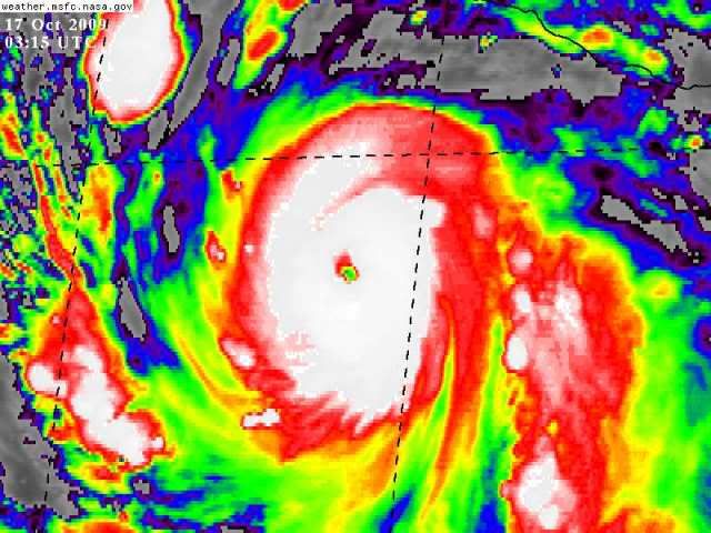
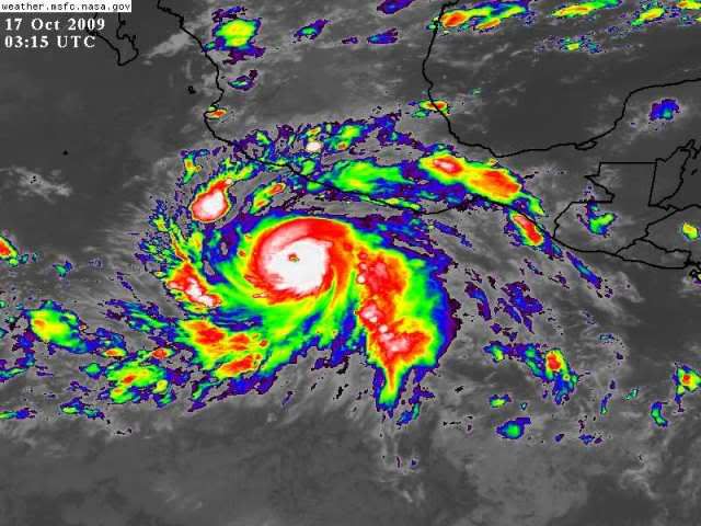
HURRICANE RICK DISCUSSION NUMBER 7
NWS TPC/NATIONAL HURRICANE CENTER MIAMI FL EP202009
200 AM PDT SAT OCT 17 2009
RICK CONTINUES TO RAPIDLY INTENSIFY. AN EYE BECAME APPARENT
IN CONVENTIONAL SATELLITE IMAGES AROUND 0200 UTC AND HAS GRADUALLY
BECOME MORE CIRCULAR OVER THE PAST FEW HOURS. IN ADDITION...THE
CLOUD PATTERN HAS CONSOLIDATED AND NOW CONSISTS OF A WELL-DEFINED
CDO WITH VERY COLD CLOUD TOPS AROUND THE EYE ALONG WITH SPIRAL OUTER
RAINBANDS. THE INITIAL INTENSITY IS RAISED TO 100 KT...IN AGREEMENT
WITH THE 0600 UTC DATA-T NUMBERS FROM TAFB AND SAB...AND THE LATEST
OBJECTIVE DVORAK CI-NUMBERS FROM UW-CIMSS.
ALL OF THE INTENSITY GUIDANCE SUGGESTS ADDITIONAL STRENGTHENING AS
THE ENVIRONMENTAL CONDITIONS REMAIN IDEAL FOR THE NEXT 24 TO 36
HOURS. THE SHIPS MODEL FORECASTS VERTICAL WIND SHEAR TO REMAIN
LIGHT OVER THE NEXT DAY OR SO AS RICK TRAVERSES WATERS AROUND 30C.
THE HWRF IS THE MOST AGGRESSIVE MODEL...BRINGING RICK TO CATEGORY
FIVE INTENSITY IN ABOUT A DAY. THE OFFICIAL FORECAST IS ABOVE THE
THE INTENSITY CONSENSUS AND SHOWS RICK PEAKING AT CATEGORY 4
STRENGTH AROUND 36 HOURS. HOWEVER...THE NHC INTENSITY PROBABILITY
TABLE SHOWS THAT THERE IS ABOUT A 10 PERCENT CHANCE OF RICK
REACHING CATEGORY FIVE INTENSITY IN ABOUT 36 HOURS. IT IS ALSO
WORTH NOTING THAT INNER CORE DYNAMICS MAY PLAY A ROLE IN THE
INTENSITY OF RICK IN THE NEXT DAY OR TWO...AND THESE FLUCTUATIONS
ARE DIFFICULT TO FORECAST. AT DAY 3 AND BEYOND...WEAKENING IS
EXPECTED DUE TO INCREASING SOUTHERLY TO SOUTHWESTERLY SHEAR AND
COOLER WATERS ALONG THE FORECAST TRACK.
THE INITIAL MOTION ESTIMATE IS 290/10...AS RICK IS BEING STEERED BY
A MID-LEVEL RIDGE EXTENDING FROM MEXICO INTO THE EASTERN PACIFIC.
THIS GENERAL MOTION IS EXPECTED TO CONTINUE FOR THE NEXT COUPLE OF
DAYS. THEREAFTER...A MID-TO UPPER LEVEL TROUGH CURRENTLY ALONG
160W IS EXPECTED TO AMPLIFY AS IT MOVES INTO THE WESTERN UNITED
STATES. THIS TROUGH WILL ERODE THE RIDGE AND ALLOW RICK TO TURN
NORTHWARD. THE HWRF AND GFDL MODELS REMAIN ON THE RIGHT SIDE OF THE
GUIDANCE ENVELOPE AND ARE MUCH FASTER THAN THE GLOBAL MODELS LATE
IN THE PERIOD. CONVERSELY...THE UKMET IS FAR TO THE LEFT AND IS
CONSIDERED AN OUTLIER AS IT APPEARS TO HAVE AN UNREALISTICALLY
SHALLOW REPRESENTATION OF THE TROPICAL CYCLONE THAT DOES NOT
RESPOND TO THE EROSION OF THE RIDGE. THE NEW TRACK FORECAST IS
BASICALLY AN UPDATE OF THE PREVIOUS ONE AND LIES CLOSE TO THE MODEL
CONSENSUS.
INTERESTS IN THE SOUTHWESTERN COAST OF MEXICO AND BAJA CALIFORNIA
SHOULD CLOSELY MONITOR THE PROGRESS OF THIS DANGEROUS HURRICANE
DURING THE NEXT SEVERAL DAYS.
FORECAST POSITIONS AND MAX WINDS
INITIAL 17/0900Z 13.9N 102.0W 100 KT
12HR VT 17/1800Z 14.3N 103.7W 110 KT
24HR VT 18/0600Z 14.9N 106.1W 120 KT
36HR VT 18/1800Z 15.7N 108.5W 125 KT
48HR VT 19/0600Z 16.5N 110.4W 120 KT
72HR VT 20/0600Z 18.4N 112.7W 110 KT
96HR VT 21/0600Z 20.5N 113.0W 95 KT
120HR VT 22/0600Z 23.5N 112.0W 80 KT
$$
FORECASTER CANGIALOSI/BRENNAN
HURRICANE RICK SPECIAL DISCUSSION NUMBER 8
NWS TPC/NATIONAL HURRICANE CENTER MIAMI FL EP202009
315 AM PDT SAT OCT 17 2009
THIS SPECIAL ADVISORY IS BEING ISSUED TO UPDATE THE CURRENT AND
FORECAST INTENSITY OF RICK...WHICH CONTINUES TO INTENSIFY AT A
REMARKABLE PACE. SUBJECTIVE AND OBJECTIVE DVORAK INTENSITY ESTIMATES
BASED ON THE LATEST INFRARED IMAGERY ARE AT LEAST 6.0...AND THE
INITIAL INTENSITY IS RAISED TO 115 KT BASED ON THESE DATA. FURTHER
STRENGTHENING SEEMS LIKELY GIVEN THE IDEAL ENVIRONMENT...AND THE
INTENSITY FORECAST HAS BEEN ADJUSTED SHARPLY UPWARD. THE NEW
OFFICIAL FORECAST SHOWS A PEAK NEAR CATEGORY 5 STATUS IN 24 HOURS
FOLLOWED BY A GRADUAL WEAKENING. INNER CORE DYNAMICS MAY ALSO
CAUSE FLUCTUATIONS IN THE INTENSITY OF THE CYCLONE DURING THE NEXT
DAY OR TWO...AND THESE FLUCTUATIONS ARE DIFFICULT TO FORECAST. AT
48 HOURS AND BEYOND...THE INTENSITY FORECAST IS UNCHANGED FROM THE
PREVIOUS ADVISORY. THE INITIAL AND FORECAST WIND RADII HAVE ALSO
BEEN ADJUSTED THROUGH 36 HOURS TO ACCOUNT FOR THE MODIFICATIONS TO
THE INITIAL AND FORECAST INTENSITY.
THE TRACK FORECAST REMAINS UNCHANGED FROM THE PREVIOUS ADVISORY.
INTERESTS IN THE SOUTHWESTERN COAST OF MEXICO AND BAJA CALIFORNIA
SHOULD CLOSELY MONITOR THE PROGRESS OF THIS EXTREMELY DANGEROUS
HURRICANE DURING THE NEXT SEVERAL DAYS.
FORECAST POSITIONS AND MAX WINDS
INITIAL 17/1015Z 14.0N 102.3W 115 KT
12HR VT 17/1800Z 14.3N 103.7W 130 KT
24HR VT 18/0600Z 14.9N 106.1W 135 KT
36HR VT 18/1800Z 15.7N 108.5W 130 KT
48HR VT 19/0600Z 16.5N 110.4W 120 KT
72HR VT 20/0600Z 18.4N 112.7W 110 KT
96HR VT 21/0600Z 20.5N 113.0W 95 KT
120HR VT 22/0600Z 23.5N 112.0W 80 KT
$$
FORECASTER BRENNAN/CANGIALOSI
NWS TPC/NATIONAL HURRICANE CENTER MIAMI FL EP202009
200 AM PDT SAT OCT 17 2009
RICK CONTINUES TO RAPIDLY INTENSIFY. AN EYE BECAME APPARENT
IN CONVENTIONAL SATELLITE IMAGES AROUND 0200 UTC AND HAS GRADUALLY
BECOME MORE CIRCULAR OVER THE PAST FEW HOURS. IN ADDITION...THE
CLOUD PATTERN HAS CONSOLIDATED AND NOW CONSISTS OF A WELL-DEFINED
CDO WITH VERY COLD CLOUD TOPS AROUND THE EYE ALONG WITH SPIRAL OUTER
RAINBANDS. THE INITIAL INTENSITY IS RAISED TO 100 KT...IN AGREEMENT
WITH THE 0600 UTC DATA-T NUMBERS FROM TAFB AND SAB...AND THE LATEST
OBJECTIVE DVORAK CI-NUMBERS FROM UW-CIMSS.
ALL OF THE INTENSITY GUIDANCE SUGGESTS ADDITIONAL STRENGTHENING AS
THE ENVIRONMENTAL CONDITIONS REMAIN IDEAL FOR THE NEXT 24 TO 36
HOURS. THE SHIPS MODEL FORECASTS VERTICAL WIND SHEAR TO REMAIN
LIGHT OVER THE NEXT DAY OR SO AS RICK TRAVERSES WATERS AROUND 30C.
THE HWRF IS THE MOST AGGRESSIVE MODEL...BRINGING RICK TO CATEGORY
FIVE INTENSITY IN ABOUT A DAY. THE OFFICIAL FORECAST IS ABOVE THE
THE INTENSITY CONSENSUS AND SHOWS RICK PEAKING AT CATEGORY 4
STRENGTH AROUND 36 HOURS. HOWEVER...THE NHC INTENSITY PROBABILITY
TABLE SHOWS THAT THERE IS ABOUT A 10 PERCENT CHANCE OF RICK
REACHING CATEGORY FIVE INTENSITY IN ABOUT 36 HOURS. IT IS ALSO
WORTH NOTING THAT INNER CORE DYNAMICS MAY PLAY A ROLE IN THE
INTENSITY OF RICK IN THE NEXT DAY OR TWO...AND THESE FLUCTUATIONS
ARE DIFFICULT TO FORECAST. AT DAY 3 AND BEYOND...WEAKENING IS
EXPECTED DUE TO INCREASING SOUTHERLY TO SOUTHWESTERLY SHEAR AND
COOLER WATERS ALONG THE FORECAST TRACK.
THE INITIAL MOTION ESTIMATE IS 290/10...AS RICK IS BEING STEERED BY
A MID-LEVEL RIDGE EXTENDING FROM MEXICO INTO THE EASTERN PACIFIC.
THIS GENERAL MOTION IS EXPECTED TO CONTINUE FOR THE NEXT COUPLE OF
DAYS. THEREAFTER...A MID-TO UPPER LEVEL TROUGH CURRENTLY ALONG
160W IS EXPECTED TO AMPLIFY AS IT MOVES INTO THE WESTERN UNITED
STATES. THIS TROUGH WILL ERODE THE RIDGE AND ALLOW RICK TO TURN
NORTHWARD. THE HWRF AND GFDL MODELS REMAIN ON THE RIGHT SIDE OF THE
GUIDANCE ENVELOPE AND ARE MUCH FASTER THAN THE GLOBAL MODELS LATE
IN THE PERIOD. CONVERSELY...THE UKMET IS FAR TO THE LEFT AND IS
CONSIDERED AN OUTLIER AS IT APPEARS TO HAVE AN UNREALISTICALLY
SHALLOW REPRESENTATION OF THE TROPICAL CYCLONE THAT DOES NOT
RESPOND TO THE EROSION OF THE RIDGE. THE NEW TRACK FORECAST IS
BASICALLY AN UPDATE OF THE PREVIOUS ONE AND LIES CLOSE TO THE MODEL
CONSENSUS.
INTERESTS IN THE SOUTHWESTERN COAST OF MEXICO AND BAJA CALIFORNIA
SHOULD CLOSELY MONITOR THE PROGRESS OF THIS DANGEROUS HURRICANE
DURING THE NEXT SEVERAL DAYS.
FORECAST POSITIONS AND MAX WINDS
INITIAL 17/0900Z 13.9N 102.0W 100 KT
12HR VT 17/1800Z 14.3N 103.7W 110 KT
24HR VT 18/0600Z 14.9N 106.1W 120 KT
36HR VT 18/1800Z 15.7N 108.5W 125 KT
48HR VT 19/0600Z 16.5N 110.4W 120 KT
72HR VT 20/0600Z 18.4N 112.7W 110 KT
96HR VT 21/0600Z 20.5N 113.0W 95 KT
120HR VT 22/0600Z 23.5N 112.0W 80 KT
$$
FORECASTER CANGIALOSI/BRENNAN
HURRICANE RICK SPECIAL DISCUSSION NUMBER 8
NWS TPC/NATIONAL HURRICANE CENTER MIAMI FL EP202009
315 AM PDT SAT OCT 17 2009
THIS SPECIAL ADVISORY IS BEING ISSUED TO UPDATE THE CURRENT AND
FORECAST INTENSITY OF RICK...WHICH CONTINUES TO INTENSIFY AT A
REMARKABLE PACE. SUBJECTIVE AND OBJECTIVE DVORAK INTENSITY ESTIMATES
BASED ON THE LATEST INFRARED IMAGERY ARE AT LEAST 6.0...AND THE
INITIAL INTENSITY IS RAISED TO 115 KT BASED ON THESE DATA. FURTHER
STRENGTHENING SEEMS LIKELY GIVEN THE IDEAL ENVIRONMENT...AND THE
INTENSITY FORECAST HAS BEEN ADJUSTED SHARPLY UPWARD. THE NEW
OFFICIAL FORECAST SHOWS A PEAK NEAR CATEGORY 5 STATUS IN 24 HOURS
FOLLOWED BY A GRADUAL WEAKENING. INNER CORE DYNAMICS MAY ALSO
CAUSE FLUCTUATIONS IN THE INTENSITY OF THE CYCLONE DURING THE NEXT
DAY OR TWO...AND THESE FLUCTUATIONS ARE DIFFICULT TO FORECAST. AT
48 HOURS AND BEYOND...THE INTENSITY FORECAST IS UNCHANGED FROM THE
PREVIOUS ADVISORY. THE INITIAL AND FORECAST WIND RADII HAVE ALSO
BEEN ADJUSTED THROUGH 36 HOURS TO ACCOUNT FOR THE MODIFICATIONS TO
THE INITIAL AND FORECAST INTENSITY.
THE TRACK FORECAST REMAINS UNCHANGED FROM THE PREVIOUS ADVISORY.
INTERESTS IN THE SOUTHWESTERN COAST OF MEXICO AND BAJA CALIFORNIA
SHOULD CLOSELY MONITOR THE PROGRESS OF THIS EXTREMELY DANGEROUS
HURRICANE DURING THE NEXT SEVERAL DAYS.
FORECAST POSITIONS AND MAX WINDS
INITIAL 17/1015Z 14.0N 102.3W 115 KT
12HR VT 17/1800Z 14.3N 103.7W 130 KT
24HR VT 18/0600Z 14.9N 106.1W 135 KT
36HR VT 18/1800Z 15.7N 108.5W 130 KT
48HR VT 19/0600Z 16.5N 110.4W 120 KT
72HR VT 20/0600Z 18.4N 112.7W 110 KT
96HR VT 21/0600Z 20.5N 113.0W 95 KT
120HR VT 22/0600Z 23.5N 112.0W 80 KT
$$
FORECASTER BRENNAN/CANGIALOSI
0 likes
Who is online
Users browsing this forum: No registered users and 46 guests