WPAC: SEVERE TROPICAL STORM LUPIT (22W)

Moderator: S2k Moderators

Message
Author
ozonepete
Professional-Met
Professional-Met
Posts: 4743
Joined: Mon Sep 07, 2009 3:23 pm
Location: From Ozone Park, NYC / Now in Brooklyn, NY

Re: WPAC: TYPHOON LUPIT (22W)

#1001 Postby ozonepete » Thu Oct 22, 2009 6:19 pm

theavocado wrote:
ozonepete wrote:This track makes much more sense to me than the JTWC one.


The problem is that JMA has been saying this for a while, yet the system keeps tracking west. I personally don't see the sudden turn. There is a weak shortwave over western china, but there appears to be a very weak finger of the STR to the north of the system that can protect it a little. I think the models are biting off on the zonal midlatitude flow, because they turn so suddenly and have been doing it for so long.


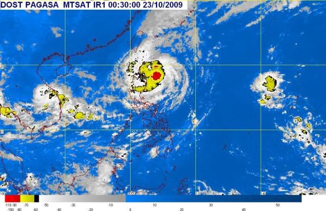
Yes, this just stays complicated because it's BEEN complicated for a while now, and none of the factors are changing significantly enough. I agree with what you said about the models and their buying into the westerlies picking it up. From the last few frames it looks like it's still basically stationary - it's hard to even get a decent fix on the center what with that raggedy eye only visible from microwave. The wobbly raggedy "eye" or center is clearly due to the really poor symmetry. At times you can actually see it getting pulled in two or three different directions at the same time. How could a radius of maximum winds or an eye ever develop under these conditions? That's why it seems all we can do is wait and watch for one of these ridges to really take hold. Til then I'm still in the JMA camp, but not because of any loyalty. I like the JTWC. It's more because most of the models have come to a consensus on a pretty sudden recurve, and it will only take one good nudge to the east to kick it off. A nudge to the west is not as likely.
Last edited by ozonepete on Thu Oct 22, 2009 6:23 pm, edited 2 times in total.
0 likes   

User avatar
StormingB81
S2K Supporter
S2K Supporter
Posts: 5676
Age: 43
Joined: Thu Aug 27, 2009 1:45 am
Location: Rockledge, Florida

#1002 Postby StormingB81 » Thu Oct 22, 2009 6:21 pm

Can this thing reorganize and become stronger?
0 likes   

ozonepete
Professional-Met
Professional-Met
Posts: 4743
Joined: Mon Sep 07, 2009 3:23 pm
Location: From Ozone Park, NYC / Now in Brooklyn, NY

Re:

#1003 Postby ozonepete » Thu Oct 22, 2009 6:24 pm

StormingB81 wrote:Can this thing reorganize and become stronger?


Not in the next few days. Hostile conditions (cooler drier air from the west) are approaching.
0 likes   

User avatar
StormingB81
S2K Supporter
S2K Supporter
Posts: 5676
Age: 43
Joined: Thu Aug 27, 2009 1:45 am
Location: Rockledge, Florida

#1004 Postby StormingB81 » Thu Oct 22, 2009 6:27 pm

SO even like JMA says if it is up near Okinawa on Monday it shouldnt be that bad? or could it stay as a Cat 1 Typhoon or Severe Tropical Storm?
0 likes   

User avatar
StormingB81
S2K Supporter
S2K Supporter
Posts: 5676
Age: 43
Joined: Thu Aug 27, 2009 1:45 am
Location: Rockledge, Florida

#1005 Postby StormingB81 » Thu Oct 22, 2009 7:16 pm

It looks like it is trying to get its act together trying to re orginize. surely it is looking better then last night
0 likes   

User avatar
JTE50
Category 1
Category 1
Posts: 336
Age: 67
Joined: Mon Jul 21, 2008 10:48 am
Location: Pensacola
Contact:

Re: WPAC: TYPHOON LUPIT (22W)

#1006 Postby JTE50 » Thu Oct 22, 2009 7:23 pm

ozonepete wrote:Too bad I can't post images, but just go look at the loops. LUPIT is on the move; it is clearly recurving around the eastern STR now and should start accelerating north or northeastward within the next few hours. This could really start moving fast soon from the looks of it.

HEADS UP, Jim! Some really heavy rain squalls headed for Appari.


During the night rain dripped in from the ceiling onto a table with my video and still cams. They are all wet now. The laptop is ok. I am dead in the water until I can find a blow dryer and hopefully get the cams dried out if they even work. There's water all over my 5K HD Cam. You can't win at this- you get the gear off the floor so flooding won't be a problem but then it comes in from the ceiling. Sheesh! Next time I put everything in a huge zip lock.
0 likes   

ozonepete
Professional-Met
Professional-Met
Posts: 4743
Joined: Mon Sep 07, 2009 3:23 pm
Location: From Ozone Park, NYC / Now in Brooklyn, NY

Re:

#1007 Postby ozonepete » Thu Oct 22, 2009 7:24 pm

StormingB81 wrote:SO even like JMA says if it is up near Okinawa on Monday it shouldnt be that bad? or could it stay as a Cat 1 Typhoon or Severe Tropical Storm?


Monday is 4 days away. To make a forecast for a tropical cyclone 4 days away, especially in these very uncertain conditions, is like tossing a coin. It's just impossible. We'll simply have to wait and see. Right now Lupit is stationary again and the intensity is fluctuating quite a bit and the best meteorologists can't figure out the next track and strength. The science is just not good enough yet to say with any certainty where this storm will be or how strong it will be 4 days from now. The odds are it will be weak and pass to the east of Okinawa, but that's a low confidence forecast. Sorry. Let's just watch and wait. We will know about Okinawa in a day or two.

The posts in this forum are NOT official forecast and should not be used as such. They are just the opinion of the poster and may or may not be backed by sound meteorological data. They are NOT endorsed by any professional institution or storm2k.org. For official information, please refer to the NHC and NWS products.
0 likes   

User avatar
StormingB81
S2K Supporter
S2K Supporter
Posts: 5676
Age: 43
Joined: Thu Aug 27, 2009 1:45 am
Location: Rockledge, Florida

#1008 Postby StormingB81 » Thu Oct 22, 2009 7:26 pm

Patience is a virtue..lol
0 likes   

ozonepete
Professional-Met
Professional-Met
Posts: 4743
Joined: Mon Sep 07, 2009 3:23 pm
Location: From Ozone Park, NYC / Now in Brooklyn, NY

Re: WPAC: TYPHOON LUPIT (22W)

#1009 Postby ozonepete » Thu Oct 22, 2009 7:26 pm

JTE50 wrote:
ozonepete wrote:Too bad I can't post images, but just go look at the loops. LUPIT is on the move; it is clearly recurving around the eastern STR now and should start accelerating north or northeastward within the next few hours. This could really start moving fast soon from the looks of it.

HEADS UP, Jim! Some really heavy rain squalls headed for Appari.


During the night rain dripped in from the ceiling onto a table with my video and still cams. They are all wet now. The laptop is ok. I am dead in the water until I can find a blow dryer and hopefully get the cams dried out if they even work. There's water all over my 5K HD Cam. You can't win at this- you get the gear off the floor so flooding won't be a problem but then it comes in from the ceiling. Sheesh! Next time I put everything in a huge zip lock.


Ugghhh! Sorry to hear that. I hope you find a blow dryer. Look for someone with 70's hair! :lol:
0 likes   

User avatar
StormingB81
S2K Supporter
S2K Supporter
Posts: 5676
Age: 43
Joined: Thu Aug 27, 2009 1:45 am
Location: Rockledge, Florida

#1010 Postby StormingB81 » Thu Oct 22, 2009 7:31 pm

Jim, You that same Guy I saw on Typhoon 2000?
0 likes   

User avatar
WindRunner
Category 5
Category 5
Posts: 5806
Age: 34
Joined: Fri Jul 29, 2005 8:07 pm
Location: Warrenton, VA, but Albany, NY for school
Contact:

#1011 Postby WindRunner » Thu Oct 22, 2009 7:35 pm

Interesting note from the JTWC prognostic reasoning product earlier today - they mentioned that the NOGAPS has returned to a westward-moving forecast over the past 12 hours. Considering that the NOGAPS does have a reasonable track record with storms in this portion of the world, I can understand the Navy's continued hesitance in changing the track forecast to the more northerly camp - especially considering the storm is still drifting west.

JTWC wrote:3. FORECAST REASONING
A. THE FORECAST REASONING HAS NOT CHANGED SIGNIFICANTLY SINCE
THE PREVIOUS PROGNOSTIC REASONING BULLETIN.
B. TY 22W IS EXPECTED TO SLOW AND LOITER IN THE WEAK STEERING
ENVIRONMENT BETWEEN THE STR TO THE EAST AND THE STR TO THE WEST.
INCREASING DRY AIR INTRUSION AND LAND INTERACTION WILL SLOWLY WEAKEN
THE SYSTEM, MAINTAINING TYPHOON STRENGTH FOR THE NEXT 12 HOURS, BUT
WILL WEAKEN TO A STRONG TROPICAL STORM THROUGH TAU 72. THE TRACK
WILL REMAIN QUASI-STATIONARY, SLOWLY DRIFTING OVER NORTHERN LUZON IN
A WEAKENING STEERING ENVIRONMENT. NUMERICAL MODELS REMAIN ERRATIC,
WITH NGPS SWITCHING FROM A NORTHERN TRACK TO A WESTWARD TRACK OVER
THE PAST 12 HOURS.
PREDOMINANTLY THE OTHER MODELS STILL SHOW A
NORTHWARD TRACK, WHICH INDICATES THEY HAVE A STRONGER EASTERN STR
AND A MORE DEVELOPED SYSTEM THAN CURRENT OBSERVATIONS INDICATE.
C. AS THE SYSTEM APPROACHES THE NORTHERN TIP OF LUZON, IT IS
EXPECTED TO CONTINUE WEAKENING AS INFLOW BECOMES DISRUPTED. THE
SYSTEM WILL CONTINUE TO TRACK SLOWLY, AND SHOULD SEE A SLIGHT
POLEWARD TURN DURING THE PASSAGE OF A SHORT-WAVE MID-LATITUDE
TROUGH. THERE REMAINS A VERY LIKELY CHANCE THAT THE SYSTEM WILL BE
PICKED UP BY THE WESTERN PERIPHERY OF THE STR TO THE EAST SOMETIME
BETWEEN TAU 12 AND TAU 36, IN WHICH CASE IT WILL TURN POLEWARD AND
START TO ACCELERATE INTO THE MID-LATITUDE WESTERLIES.//
0 likes   

ozonepete
Professional-Met
Professional-Met
Posts: 4743
Joined: Mon Sep 07, 2009 3:23 pm
Location: From Ozone Park, NYC / Now in Brooklyn, NY

Re:

#1012 Postby ozonepete » Thu Oct 22, 2009 7:41 pm

WindRunner wrote:Interesting note from the JTWC prognostic reasoning product earlier today - they mentioned that the NOGAPS has returned to a westward-moving forecast over the past 12 hours. Considering that the NOGAPS does have a reasonable track record with storms in this portion of the world, I can understand the Navy's continued hesitance in changing the track forecast to the more northerly camp - especially considering the storm is still drifting west.

JTWC wrote:3. FORECAST REASONING
A. THE FORECAST REASONING HAS NOT CHANGED SIGNIFICANTLY SINCE
THE PREVIOUS PROGNOSTIC REASONING BULLETIN.
B. TY 22W IS EXPECTED TO SLOW AND LOITER IN THE WEAK STEERING
ENVIRONMENT BETWEEN THE STR TO THE EAST AND THE STR TO THE WEST.
INCREASING DRY AIR INTRUSION AND LAND INTERACTION WILL SLOWLY WEAKEN
THE SYSTEM, MAINTAINING TYPHOON STRENGTH FOR THE NEXT 12 HOURS, BUT
WILL WEAKEN TO A STRONG TROPICAL STORM THROUGH TAU 72. THE TRACK
WILL REMAIN QUASI-STATIONARY, SLOWLY DRIFTING OVER NORTHERN LUZON IN
A WEAKENING STEERING ENVIRONMENT. NUMERICAL MODELS REMAIN ERRATIC,
WITH NGPS SWITCHING FROM A NORTHERN TRACK TO A WESTWARD TRACK OVER
THE PAST 12 HOURS.
PREDOMINANTLY THE OTHER MODELS STILL SHOW A
NORTHWARD TRACK, WHICH INDICATES THEY HAVE A STRONGER EASTERN STR
AND A MORE DEVELOPED SYSTEM THAN CURRENT OBSERVATIONS INDICATE.
C. AS THE SYSTEM APPROACHES THE NORTHERN TIP OF LUZON, IT IS
EXPECTED TO CONTINUE WEAKENING AS INFLOW BECOMES DISRUPTED. THE
SYSTEM WILL CONTINUE TO TRACK SLOWLY, AND SHOULD SEE A SLIGHT
POLEWARD TURN DURING THE PASSAGE OF A SHORT-WAVE MID-LATITUDE
TROUGH. THERE REMAINS A VERY LIKELY CHANCE THAT THE SYSTEM WILL BE
PICKED UP BY THE WESTERN PERIPHERY OF THE STR TO THE EAST SOMETIME
BETWEEN TAU 12 AND TAU 36, IN WHICH CASE IT WILL TURN POLEWARD AND
START TO ACCELERATE INTO THE MID-LATITUDE WESTERLIES.//


I was wondering why they are going against the consensus of the models and agency forecasts. That could at least partially explain it.
0 likes   

User avatar
StormingB81
S2K Supporter
S2K Supporter
Posts: 5676
Age: 43
Joined: Thu Aug 27, 2009 1:45 am
Location: Rockledge, Florida

#1013 Postby StormingB81 » Thu Oct 22, 2009 7:56 pm

It will just have us on edge until it begins to move. Until then we will all anxiously wait.
0 likes   

oaba09
S2K Supporter
S2K Supporter
Posts: 1496
Age: 38
Joined: Thu Oct 01, 2009 10:02 am
Location: Valenzuela, Philippines
Contact:

#1014 Postby oaba09 » Thu Oct 22, 2009 8:07 pm

And I thought Luzon is already spared....I feel bad for the people of aparri...They're not a rich town....I'm sure they're gonna have a tough time recovering....

Jim, has the flooding started???
0 likes   

User avatar
breeze
Category 5
Category 5
Posts: 9110
Age: 62
Joined: Sat Feb 08, 2003 4:55 pm
Location: Lawrenceburg, TN

Re: WPAC: TYPHOON LUPIT (22W)

#1015 Postby breeze » Thu Oct 22, 2009 8:24 pm

Are people in central Luzon and metro Manilla keeping a closer eye on this system now?
0 likes   

User avatar
cycloneye
Admin
Admin
Posts: 145276
Age: 68
Joined: Thu Oct 10, 2002 10:54 am
Location: San Juan, Puerto Rico

Re: WPAC: TYPHOON LUPIT (22W)

#1016 Postby cycloneye » Thu Oct 22, 2009 8:26 pm

JMA 00 UTC Warning

JMA has it stationary now and the track is once again away from Luzon and east of Okinawa.

TY 0920 (Lupit)
Issued at 00:50 UTC, 23 October 2009
<Analyses at 23/00 UTC>
Scale -
Intensity Strong
Center position N18°40'(18.7°)
E123°05'(123.1°)
Direction and speed of movement STR
Central pressure 970hPa
Maximum wind speed near the center 35m/s(65kt)
Maximum wind gust speed 50m/s(95kt)
Area of 50kt winds or more Wide 130km(70NM)
Area of 30kt winds or more NW520km(280NM)
SE370km(200NM)

<Forecast for 24/00 UTC>
Intensity Strong
Center position of probability circle N19°20'(19.3°)
E122°55'(122.9°)
Direction and speed of movement STR
Central pressure 970hPa
Maximum wind speed near the center 35m/s(65kt)
Maximum wind gust speed 50m/s(95kt)
Radius of probability circle 130km(70NM)
Storm warning area Wide 260km(140NM)

<Forecast for 25/00 UTC>
Intensity Strong
Center position of probability circle N20°35'(20.6°)
E123°05'(123.1°)
Direction and speed of movement N Slowly
Central pressure 970hPa
Maximum wind speed near the center 35m/s(65kt)
Maximum wind gust speed 50m/s(95kt)
Radius of probability circle 300km(160NM)
Storm warning area Wide 430km(230NM)

<Forecast for 26/00 UTC>
Intensity Strong
Center position of probability circle N22°00'(22.0°)
E123°50'(123.8°)
Direction and speed of movement NNE Slowly
Central pressure 970hPa
Maximum wind speed near the center 35m/s(65kt)
Maximum wind gust speed 50m/s(95kt)
Radius of probability circle 410km(220NM)
Storm warning area Wide 540km(290NM)

Image
0 likes   
Visit the Caribbean-Central America Weather Thread where you can find at first post web cams,radars
and observations from Caribbean basin members Click Here

User avatar
Infdidoll
Category 2
Category 2
Posts: 667
Age: 47
Joined: Thu Oct 01, 2009 8:39 pm
Location: Temecula, CA

Re: WPAC: TYPHOON LUPIT (22W)

#1017 Postby Infdidoll » Thu Oct 22, 2009 8:27 pm

JTE50 wrote:
ozonepete wrote:Too bad I can't post images, but just go look at the loops. LUPIT is on the move; it is clearly recurving around the eastern STR now and should start accelerating north or northeastward within the next few hours. This could really start moving fast soon from the looks of it.

HEADS UP, Jim! Some really heavy rain squalls headed for Appari.


During the night rain dripped in from the ceiling onto a table with my video and still cams. They are all wet now. The laptop is ok. I am dead in the water until I can find a blow dryer and hopefully get the cams dried out if they even work. There's water all over my 5K HD Cam. You can't win at this- you get the gear off the floor so flooding won't be a problem but then it comes in from the ceiling. Sheesh! Next time I put everything in a huge zip lock.


I feel sick just reading that! I hope you're able to find a blow dryer...and more importantly, I hope they work afterwards!
0 likes   

User avatar
Infdidoll
Category 2
Category 2
Posts: 667
Age: 47
Joined: Thu Oct 01, 2009 8:39 pm
Location: Temecula, CA

Re:

#1018 Postby Infdidoll » Thu Oct 22, 2009 8:29 pm

StormingB81 wrote:It will just have us on edge until it begins to move. Until then we will all anxiously wait.


Those of us on Okinawa can't help feeling anxious while we wait and I know those in the Philippines were just as nervous when it was coming their way. All the worrying can be ulcer-inducing, but that's the plight of a weather-watcher with the potential to face the music head on.

I hope everyone can forgive our nerves getting the best of us. :wink:
0 likes   

I-wall
Tropical Storm
Tropical Storm
Posts: 210
Joined: Wed Sep 10, 2008 5:24 pm

Re: Re:

#1019 Postby I-wall » Thu Oct 22, 2009 8:35 pm

ozonepete wrote:
StormingB81 wrote:SO even like JMA says if it is up near Okinawa on Monday it shouldnt be that bad? or could it stay as a Cat 1 Typhoon or Severe Tropical Storm?


Monday is 4 days away. To make a forecast for a tropical cyclone 4 days away, especially in these very uncertain conditions, is like tossing a coin. It's just impossible. We'll simply have to wait and see. Right now Lupit is stationary again and the intensity is fluctuating quite a bit and the best meteorologists can't figure out the next track and strength. The science is just not good enough yet to say with any certainty where this storm will be or how strong it will be 4 days from now. The odds are it will be weak and pass to the east of Okinawa, but that's a low confidence forecast. Sorry. Let's just watch and wait. We will know about Okinawa in a day or two.

The posts in this forum are NOT official forecast and should not be used as such. They are just the opinion of the poster and may or may not be backed by sound meteorological data. They are NOT endorsed by any professional institution or storm2k.org. For official information, please refer to the NHC and NWS products.


Nicely put. Very good advice. Thanks for all the sound reasoning you bring here for the rest us to learn from. It's much appreciated!! By the way Pete, where does the "ozone" portion of your name come from? Is it a reference to the ozone created during thunderstorms, or the ozone layer, or what? I have a little experience with ozone, so i'm curious.

Back on topic....do you know where we can get radar images up where Jim is located? Thanks!
0 likes   

ozonepete
Professional-Met
Professional-Met
Posts: 4743
Joined: Mon Sep 07, 2009 3:23 pm
Location: From Ozone Park, NYC / Now in Brooklyn, NY

Re:

#1020 Postby ozonepete » Thu Oct 22, 2009 8:39 pm

oaba09 wrote:And I thought Luzon is already spared....I feel bad for the people of aparri...They're not a rich town....I'm sure they're gonna have a tough time recovering....

Jim, has the flooding started???


Hi oaba09,
There's no serious condition yet, so please don't worry at this time. Here is your recent satellite from PAGASA. It indicates that the rains and winds at Aparri are probably moderate but not heavy. I'm still looking for reports, but so far it looks like they are not doing very badly. The really heavy rain and worst conditions are WAY offshore to the east. If conditions really get bad, you will know. Somebody will report it here. But there are no forecasts right now for dire conditions anywhere in Luzon, because this storm is weakening and most likely will start moving away within 24 hours. That's the consensus at this time anyway. Hang in there.

Image
0 likes   


Return to “2009”

Who is online

Users browsing this forum: No registered users and 4 guests