EAST COAST : Tropical Depression ONE

Moderator: S2k Moderators

Message
Author
User avatar
HURAKAN
Professional-Met
Professional-Met
Posts: 46086
Age: 37
Joined: Thu May 20, 2004 4:34 pm
Location: Key West, FL
Contact:

#121 Postby HURAKAN » Thu May 28, 2009 6:58 am

Loop: http://hadar.cira.colostate.edu/ramsdis ... ive_0.html

Image

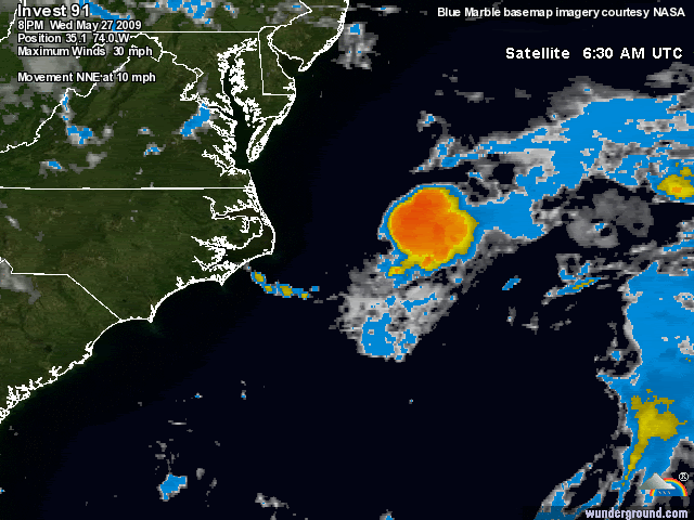
Convection is popping over the center. Now is when we need the RECON.
0 likes   

User avatar
Thunder44
Category 5
Category 5
Posts: 5922
Age: 43
Joined: Mon Jun 09, 2003 7:53 pm
Location: New York City

Re:

#122 Postby Thunder44 » Thu May 28, 2009 7:00 am

HURAKAN wrote:We need to hear from the NHC.


Personally, I think they are just going to leave it alone. But they just issued this:

000
ABNT20 KNHC 281156
TWOAT
SPECIAL TROPICAL WEATHER OUTLOOK
NWS TPC/NATIONAL HURRICANE CENTER MIAMI FL
755 AM EDT THU MAY 28 2009

FOR THE NORTH ATLANTIC...CARIBBEAN SEA AND THE GULF OF MEXICO...

SHOWER ACTIVITY HAS INCREASED THIS MORNING IN ASSOCIATION WITH THE
AREA OF LOW PRESSURE LOCATED ABOUT 225 MILES EAST-NORTHEAST OF CAPE
HATTERAS NORTH CAROLINA. THE LOW IS CURRENTLY MOVING TO THE
NORTHEAST AT 15 MPH ALONG THE RELATIVELY WARM WATERS OF THE GULF
STREAM. THIS SYSTEM STILL HAS SOME POTENTIAL TO BECOME A TROPICAL
CYCLONE OVER THE NEXT 12-24 HOURS BUT IS NOT EXPECTED TO THREATEN
ANY LAND AREAS. THERE IS A LOW CHANCE...LESS THAN 30 PERCENT...OF
THIS SYSTEM BECOMING A TROPICAL CYCLONE DURING THE NEXT 48 HOURS.
AN ADDITIONAL SPECIAL TROPICAL WEATHER OUTLOOK WILL BE ISSUED AT 2
PM THIS AFTERNOON.

$$
FORECASTER FRANKLIN/BEVEN
0 likes   

User avatar
HURAKAN
Professional-Met
Professional-Met
Posts: 46086
Age: 37
Joined: Thu May 20, 2004 4:34 pm
Location: Key West, FL
Contact:

#123 Postby HURAKAN » Thu May 28, 2009 7:05 am

Tropical Storm Hermine:

Image

91L:

Image

They look interestingly similar.
0 likes   

User avatar
HURAKAN
Professional-Met
Professional-Met
Posts: 46086
Age: 37
Joined: Thu May 20, 2004 4:34 pm
Location: Key West, FL
Contact:

#124 Postby HURAKAN » Thu May 28, 2009 7:09 am

1200:

AL, 91, 2009052812, , BEST, 0, 370N, 720W, 25, 1007, LO

The status changed from "DB" Disturbance to "LO" Low.
0 likes   

User avatar
HURAKAN
Professional-Met
Professional-Met
Posts: 46086
Age: 37
Joined: Thu May 20, 2004 4:34 pm
Location: Key West, FL
Contact:

#125 Postby HURAKAN » Thu May 28, 2009 7:25 am

Image
0 likes   

User avatar
HURAKAN
Professional-Met
Professional-Met
Posts: 46086
Age: 37
Joined: Thu May 20, 2004 4:34 pm
Location: Key West, FL
Contact:

#126 Postby HURAKAN » Thu May 28, 2009 7:33 am

Image

I think it's organized enough to be upgraded. It looks great compared to how it has looked in the past few days.

28/0545 UTC 36.0N 72.9W T1.0/1.0 91L -- Atlantic
0 likes   

User avatar
cycloneye
Admin
Admin
Posts: 139709
Age: 67
Joined: Thu Oct 10, 2002 10:54 am
Location: San Juan, Puerto Rico

Re: East Coast : INVEST 91L

#127 Postby cycloneye » Thu May 28, 2009 7:35 am

What about 1.5?

28/1145 UTC 37.1N 71.5W T1.5/1.5 91L -- Atlantic
0 likes   

User avatar
HURAKAN
Professional-Met
Professional-Met
Posts: 46086
Age: 37
Joined: Thu May 20, 2004 4:34 pm
Location: Key West, FL
Contact:

Re: East Coast : INVEST 91L

#128 Postby HURAKAN » Thu May 28, 2009 7:37 am

cycloneye wrote:What about 1.5?


It just appeared! Didn't see it.
0 likes   

User avatar
cycloneye
Admin
Admin
Posts: 139709
Age: 67
Joined: Thu Oct 10, 2002 10:54 am
Location: San Juan, Puerto Rico

Re: Model Guidance : INVEST 91L

#129 Postby cycloneye » Thu May 28, 2009 7:47 am

They keep doing runs for 91L.

427
WHXX01 KWBC 281245
CHGHUR
TROPICAL CYCLONE GUIDANCE MESSAGE
NWS TPC/NATIONAL HURRICANE CENTER MIAMI FL
1245 UTC THU MAY 28 2009

DISCLAIMER...NUMERICAL MODELS ARE SUBJECT TO LARGE ERRORS.
PLEASE REFER TO NHC OFFICIAL FORECASTS FOR TROPICAL CYCLONE
AND SUBTROPICAL CYCLONE INFORMATION.

ATLANTIC OBJECTIVE AIDS FOR

DISTURBANCE INVEST (AL912009) 20090528 1200 UTC

...00 HRS... ...12 HRS... ...24 HRS. .. ...36 HRS...
090528 1200 090529 0000 090529 1200 090530 0000

LAT LON LAT LON LAT LON LAT LON
BAMS 37.1N 71.5W 38.8N 69.0W 40.9N 66.7W 43.5N 63.5W
BAMD 37.1N 71.5W 38.6N 67.8W 39.7N 63.2W 40.7N 58.2W
BAMM 37.1N 71.5W 38.8N 68.4W 40.6N 65.0W 42.8N 60.9W
LBAR 37.1N 71.5W 38.7N 67.8W 39.5N 63.3W 39.6N 58.0W
SHIP 25KTS 27KTS 29KTS 30KTS
DSHP 25KTS 27KTS 29KTS 30KTS

...48 HRS... ...72 HRS... ...96 HRS. .. ..120 HRS...
090530 1200 090531 1200 090601 1200 090602 1200

LAT LON LAT LON LAT LON LAT LON
BAMS 46.3N 59.4W 51.1N 53.3W 55.8N 53.1W 60.2N 54.2W
BAMD 41.4N 53.0W 39.2N 44.8W 34.8N 43.1W 31.6N 43.5W
BAMM 45.2N 55.6W 46.5N 44.2W 43.6N 40.3W 38.9N 37.4W
LBAR 38.6N 52.5W 36.0N 45.2W 33.1N 45.3W 29.0N 47.6W
SHIP 31KTS 30KTS 27KTS 18KTS
DSHP 31KTS 30KTS 27KTS 18KTS

...INITIAL CONDITIONS...
LATCUR = 37.1N LONCUR = 71.5W DIRCUR = 45DEG SPDCUR = 14KT
LATM12 = 35.1N LONM12 = 74.0W DIRM12 = 39DEG SPDM12 = 11KT
LATM24 = 33.6N LONM24 = 75.2W
WNDCUR = 25KT RMAXWD = 40NM WNDM12 = 25KT
CENPRS = 1007MB OUTPRS = 1011MB OUTRAD = 90NM SDEPTH = M
RD34NE = 0NM RD34SE = 0NM RD34SW = 0NM RD34NW = 0NM
0 likes   

User avatar
HURAKAN
Professional-Met
Professional-Met
Posts: 46086
Age: 37
Joined: Thu May 20, 2004 4:34 pm
Location: Key West, FL
Contact:

#130 Postby HURAKAN » Thu May 28, 2009 8:27 am

Image

Image

Beautiful system.
0 likes   

User avatar
HURAKAN
Professional-Met
Professional-Met
Posts: 46086
Age: 37
Joined: Thu May 20, 2004 4:34 pm
Location: Key West, FL
Contact:

Re: East Coast : INVEST 91L

#131 Postby HURAKAN » Thu May 28, 2009 8:32 am

Disturbance 91L more organized, but headed out to sea

Posted by: JeffMasters, 1:18 PM GMT on May 28, 2009
An area of disturbed weather (91L), located about 250 miles east-northeast of Cape Hatteras North Carolina, has shown a modest increase in heavy thunderstorm activity this morning. QuikSCAT imagery from last night revealed a closed surface circulation, but top winds of only 20 - 25 mph.

The disturbance is over the relatively warm waters of the Gulf Stream (25°C) and has wind shear of 10 - 15 knots over it, and these conditions are marginally favorable for some slow development to occur until this evening, when the system will begin moving over waters too cold to support tropical cyclone development. The disturbance will track northeastward at 15 mph today, and and is not a threat to any land areas. In a Special Tropical Weather Outlook issued at 8am EDT this morning, NHC gave 91L a low (less than 30% chance) of developing into a tropical depression.
0 likes   

User avatar
wxman57
Moderator-Pro Met
Moderator-Pro Met
Posts: 22512
Age: 66
Joined: Sat Jun 21, 2003 8:06 pm
Location: Houston, TX (southwest)

Re: East Coast : INVEST 91L

#132 Postby wxman57 » Thu May 28, 2009 8:35 am

It certainly has some convection now, but I think that convection is east of any LLC. Let's hope they just let it accelerate out to sea.
0 likes   

User avatar
wxman57
Moderator-Pro Met
Moderator-Pro Met
Posts: 22512
Age: 66
Joined: Sat Jun 21, 2003 8:06 pm
Location: Houston, TX (southwest)

Re:

#133 Postby wxman57 » Thu May 28, 2009 8:38 am

capepoint wrote:I'll second the motion for the next invest to be in september. All in favor......
Seriously tho....
A question to you pro-mets and experienced amatures....
I read somewhere that it seems that the models did correctly indicate the start-up of these two lows, but I dont know if they are also giving false alarms. I seem to remember last year the models giving several false alarms that never materialized. Could it be that the models are doing better this year, or have I just not been paying much attention.

thanks


The GFS has been forecasting something to develop on just about every run for the past 6 weeks. It's always in the long range - 10-15 days out. So, yes, it did forecast the development of both 90L and 91L, along with a dozen other systems (or more) that never materialized.
0 likes   

User avatar
HURAKAN
Professional-Met
Professional-Met
Posts: 46086
Age: 37
Joined: Thu May 20, 2004 4:34 pm
Location: Key West, FL
Contact:

#134 Postby HURAKAN » Thu May 28, 2009 8:47 am

Image

"I'll be back!!!" Some models indicating a turn around.
0 likes   

User avatar
HURAKAN
Professional-Met
Professional-Met
Posts: 46086
Age: 37
Joined: Thu May 20, 2004 4:34 pm
Location: Key West, FL
Contact:

#135 Postby HURAKAN » Thu May 28, 2009 8:59 am

Image
0 likes   

Derek Ortt

#136 Postby Derek Ortt » Thu May 28, 2009 9:02 am

put a floater on it

http://www.nwhhc.com/satellite.html

invest_02
0 likes   

margiek
Tropical Depression
Tropical Depression
Posts: 72
Joined: Fri Nov 28, 2008 9:50 pm

Re: East Coast : INVEST 91L

#137 Postby margiek » Thu May 28, 2009 9:07 am

Looks like a developing midget TC.
0 likes   

User avatar
HURAKAN
Professional-Met
Professional-Met
Posts: 46086
Age: 37
Joined: Thu May 20, 2004 4:34 pm
Location: Key West, FL
Contact:

#138 Postby HURAKAN » Thu May 28, 2009 9:46 am

Image

NRL dropping the system but when you go to year 2009 it says 01L. ONE!
0 likes   

User avatar
wyq614
Category 3
Category 3
Posts: 827
Age: 36
Joined: Sun Dec 02, 2007 12:32 am
Location: Beijing, China (Hometown: Qingdao, China, 36.06N 120.43E)
Contact:

#139 Postby wyq614 » Thu May 28, 2009 10:18 am

TD One is here, minimal TS in 12-24 hours
0 likes   

Aric Dunn
Category 5
Category 5
Posts: 21228
Age: 41
Joined: Sun Sep 19, 2004 9:58 pm
Location: Ready for the Chase.
Contact:

#140 Postby Aric Dunn » Thu May 28, 2009 10:18 am

we have TD 1

let this be stark reminder to all that what we think we know .. is not always the case

including all pro mets
Last edited by Aric Dunn on Thu May 28, 2009 10:18 am, edited 1 time in total.
0 likes   


Return to “2009”

Who is online

Users browsing this forum: No registered users and 6 guests