
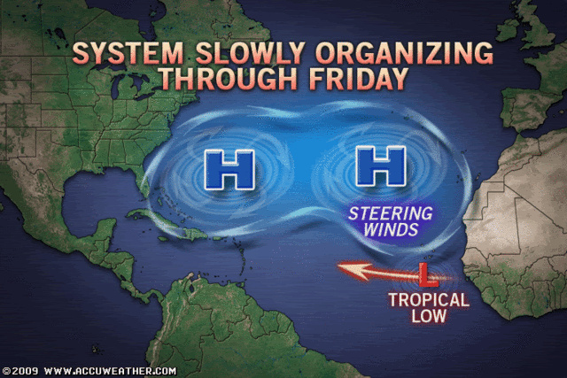
The thing is the resolution goes down the pan so its very hard to know whether the high wil lbe stronger then the resolution shows, or whether the trough wil lbe a little sharper...
My worry is the GFS and ECM both tend to over-fetch troughs after 144hrs (to my winter annoyence!) and thats a big deal in this set-up, even if its only slightly...
ATL: TROPICAL STORM BILL (03L)
Moderator: S2k Moderators
-
CrazyC83
- Professional-Met

- Posts: 34315
- Joined: Tue Mar 07, 2006 11:57 pm
- Location: Deep South, for the first time!
Re: ATL: Invest 90L Models
JPmia wrote:to me it implies a more NW turn after PR...high is retreating east...the question is how much will the high retreat and how much will the storm turn NW or N...
Maybe something similar to Hortense in 1996 or Marilyn in 1995?
0 likes


Re: ATL: Invest 90L Models
well there is one clear pattern to the models and that is the NE or Eastern Caribbean islands *could* be under a threat in 6 days...they need to watch this more than any of us right now.
0 likes
Re: ATL: Invest 90L
It'll be interesting to see if the dry air that's weakened TD2 to a low cloud swirl will help to keep 90L in check - it's very close to that area, so it's bound to do something to it...
Frank
Frank
0 likes

I forget which system it was about 5 years ago that was just as large - but it seemed to be so large that it never did get it's act together, or if it did it was minimal...
Perhaps someone here remembers that system...
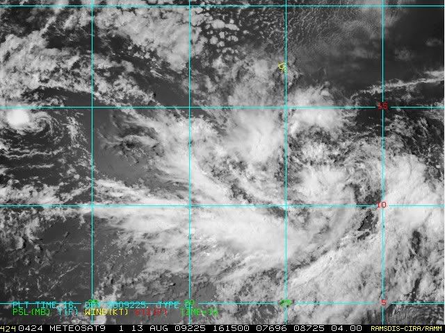
P.S. There doesn't seem to be too much in the way of cold cloud tops with 90L at this time - just lots of feeder bands...
Perhaps someone here remembers that system...
P.S. There doesn't seem to be too much in the way of cold cloud tops with 90L at this time - just lots of feeder bands...
0 likes
-
SunnyThoughts
- Category 5

- Posts: 2263
- Joined: Wed Jul 09, 2003 12:42 pm
- Location: Pensacola, Florida
-
tolakram
- Admin

- Posts: 20186
- Age: 62
- Joined: Sun Aug 27, 2006 8:23 pm
- Location: Florence, KY (name is Mark)
Re:
dolebot_Broward_NW wrote:Climatalogicaly (spelling?) speaking - every single storm since 1900 forming in the area where both 90L and TD2 exist have recurved. Just a statement.
Same was said with Ike. We really don't have enough data in individual areas to make strong correlations like that.
Take a look at the TD2 historical map (thanks to WeatherUnderground)
That's not a lot of data, and one of those storms really sticks out at ya. 3 did not recurve by the way.
0 likes
-
cycloneye

- Admin
- Posts: 149579
- Age: 69
- Joined: Thu Oct 10, 2002 10:54 am
- Location: San Juan, Puerto Rico
Re: ATL: Invest 90L Models
12z CMC
It also has a major threat to the NE Caribbean.

http://moe.met.fsu.edu/cgi-bin/cmctc2.c ... =Animation
It also has a major threat to the NE Caribbean.
http://moe.met.fsu.edu/cgi-bin/cmctc2.c ... =Animation
0 likes

Re: ATL: Invest 90L
Forgive my lack of knowledge, but won't the same factors that are hindering td2 affect 90 L in the same or similar way? If there is so much dry air and shear, how can 90 L overcome them when td2 hasn't been able to? I wonder if 90L will go away soon, also, regardless of its size.
0 likes
-
tolakram
- Admin
- Posts: 20186
- Age: 62
- Joined: Sun Aug 27, 2006 8:23 pm
- Location: Florence, KY (name is Mark)
Re: ATL: Invest 90L
sunnyday wrote:Forgive my lack of knowledge, but won't the same factors that are hindering td2 affect 90 L in the same or similar way? If there is so much dry air and shear, how can 90 L overcome them when td2 hasn't been able to? I wonder if 90L will go away soon, also, regardless of its size.
I'm not a pro or even a very good amateur.
I think the answer is yes it could, but 90L is further south and has more moisture around it plus warmer sea surface temps, which will counteract the shear a bit, as long as the shear is not too great.
Total Precipitable Water
http://cimss.ssec.wisc.edu/tropic/real- ... /main.html
Looking at that loop you can see 90L with a lot of moisture around it.
24hr Shear Tendency
http://cimss.ssec.wisc.edu/tropic/real- ... g8sht.html
Looking at this you can see wind shear tendency (the lines) and shear (the colors).
and here is the current sat pics of the disturbance to use until it gets into the range of GOES.
http://oiswww.eumetsat.org/IPPS/html/MS ... ESOLUTION/
0 likes
-
cajungal
- Category 5
- Posts: 2354
- Age: 49
- Joined: Sun Mar 14, 2004 9:34 pm
- Location: Schriever, Louisiana (60 miles southwest of New Orleans)
Re: ATL: Invest 90L
first we need to see if it actually develops. the first threat would be to our friends in the caribbean. If it actually becomes a depression, and has a closed center of circulation, then we will have a better idea of its path. whether it would be a fish and not hit the US. which would be the best news. or a East Coast threat or a gulf threat.
0 likes
To the north Cycloneye, probably only be rain an gusty winds with that I'd suspect.
Rather like the ECM, shows that NW jog in the central Atlantic as the weakness goes past it...if that doesn't happen like then the outcome will be pretty much exactly the same as the GFS...
We shall see but I think some models are overdoing the jump the NW, the GFS has no such feature. We need to see other 12z runs.
0 likes
-
cycloneye
- Admin
- Posts: 149579
- Age: 69
- Joined: Thu Oct 10, 2002 10:54 am
- Location: San Juan, Puerto Rico
Re: ATL: Invest 90L Models
If the CMC scenario pans out,its too close for confort I may say.
0 likes


Re:
gatorcane wrote:12Z GFS has a hit on Puerto Rico, Leewards and a very close call for Southern FL -- too close for a 240+ hour run in my opinion.
Will be watching closely on this one still.
Gator - Too close on a 10 day run? What is the margin of error on a 10 day run lol.
0 likes
Who is online
Users browsing this forum: No registered users and 65 guests