EPAC : TROPICAL DEPRESSION RICK (20E)

Moderator: S2k Moderators

Message
Author
User avatar
HURAKAN
Professional-Met
Professional-Met
Posts: 46086
Age: 37
Joined: Thu May 20, 2004 4:34 pm
Location: Key West, FL
Contact:

#121 Postby HURAKAN » Sat Oct 17, 2009 5:24 am

Image

Latest
0 likes   

User avatar
HURAKAN
Professional-Met
Professional-Met
Posts: 46086
Age: 37
Joined: Thu May 20, 2004 4:34 pm
Location: Key West, FL
Contact:

#122 Postby HURAKAN » Sat Oct 17, 2009 5:30 am

Image

Image

Very impressive storm
0 likes   

User avatar
HURAKAN
Professional-Met
Professional-Met
Posts: 46086
Age: 37
Joined: Thu May 20, 2004 4:34 pm
Location: Key West, FL
Contact:

Re: EPAC : HURRICANE RICK (20E)

#123 Postby HURAKAN » Sat Oct 17, 2009 5:31 am

UW - CIMSS
ADVANCED DVORAK TECHNIQUE
ADT-Version 7.2.3
Tropical Cyclone Intensity Algorithm

----- Current Analysis -----
Date : 17 OCT 2009 Time : 091500 UTC
Lat : 13:57:54 N Lon : 102:06:02 W

CI# /Pressure/ Vmax
6.1 / 948.5mb/117.4kt


Final T# Adj T# Raw T#
(3hr avg)
6.1 6.4 6.7

Latitude bias adjustment to MSLP : +3.1mb

Estimated radius of max. wind based on IR : 17 km

Center Temp : -3.4C Cloud Region Temp : -70.9C

Scene Type : EYE

Positioning Method : RING/SPIRAL COMBINATION

Ocean Basin : EAST PACIFIC
Dvorak CI > MSLP Conversion Used : ATLANTIC

Tno/CI Rules : Constraint Limits : 2.2T/6hr
Weakening Flag : OFF
Rapid Dissipation Flag : OFF

****************************************************

0 likes   

User avatar
cycloneye
Admin
Admin
Posts: 139411
Age: 67
Joined: Thu Oct 10, 2002 10:54 am
Location: San Juan, Puerto Rico

Re: EPAC : HURRICANE RICK (20E)=Special Advisory,115kts,cat 4

#124 Postby cycloneye » Sat Oct 17, 2009 6:16 am

This will be bad and good.Bad for portions of Mexican coast/Baja,good for Texas as all the moisture will go that way to hopefully aliviate or end the drought in that state.
0 likes   
Visit the Caribbean-Central America Weather Thread where you can find at first post web cams,radars
and observations from Caribbean basin members Click Here

User avatar
cycloneye
Admin
Admin
Posts: 139411
Age: 67
Joined: Thu Oct 10, 2002 10:54 am
Location: San Juan, Puerto Rico

Re: EPAC : HURRICANE RICK (20E)=Special Advisory,115kts,cat 4

#125 Postby cycloneye » Sat Oct 17, 2009 6:29 am

More than impressive.That dot in the upper left portion of image is the island of Socorro.As it gets closer to that island,lets follow the observations from there.

Image
0 likes   
Visit the Caribbean-Central America Weather Thread where you can find at first post web cams,radars
and observations from Caribbean basin members Click Here

RL3AO
Moderator-Pro Met
Moderator-Pro Met
Posts: 16308
Joined: Thu Jun 14, 2007 10:03 pm
Location: NC

#126 Postby RL3AO » Sat Oct 17, 2009 6:45 am

Very, very impressive.
0 likes   

User avatar
Kingarabian
S2K Supporter
S2K Supporter
Posts: 15451
Joined: Sat Aug 08, 2009 3:06 am
Location: Honolulu, Hawaii

#127 Postby Kingarabian » Sat Oct 17, 2009 6:48 am

Image
0 likes   
RIP Kobe Bryant

User avatar
cycloneye
Admin
Admin
Posts: 139411
Age: 67
Joined: Thu Oct 10, 2002 10:54 am
Location: San Juan, Puerto Rico

Re: EPAC : HURRICANE RICK (20E)=Special Advisory,115kts,cat 4

#128 Postby cycloneye » Sat Oct 17, 2009 7:17 am

Macrocane,you posted a good site for the observations last night but I found another one this morning to look at the observations in the Mexican coast,island of Socorro and Baja.

http://meteorologia.semar.gob.mx/redemas.php
0 likes   
Visit the Caribbean-Central America Weather Thread where you can find at first post web cams,radars
and observations from Caribbean basin members Click Here

O Town
S2K Supporter
S2K Supporter
Posts: 5203
Age: 50
Joined: Wed Sep 07, 2005 9:37 pm
Location: Orlando, Florida 28°35'35"N 81°22'55"W

#129 Postby O Town » Sat Oct 17, 2009 7:42 am

Wow looks like our little ex 92L has turned into quite the angry storm.


Image
0 likes   

#ORLANDOSTRONG

User avatar
cycloneye
Admin
Admin
Posts: 139411
Age: 67
Joined: Thu Oct 10, 2002 10:54 am
Location: San Juan, Puerto Rico

Re: EPAC : HURRICANE RICK (20E)=Special Advisory,115kts,cat 4

#130 Postby cycloneye » Sat Oct 17, 2009 7:43 am

TROPICAL CYCLONE GUIDANCE MESSAGE
NWS TPC/NATIONAL HURRICANE CENTER MIAMI FL
1234 UTC SAT OCT 17 2009

DISCLAIMER...NUMERICAL MODELS ARE SUBJECT TO LARGE ERRORS.
PLEASE REFER TO NHC OFFICIAL FORECASTS FOR TROPICAL CYCLONE
AND SUBTROPICAL CYCLONE INFORMATION.

EAST PACIFIC OBJECTIVE AIDS FOR

TROPICAL CYCLONE RICK (EP202009) 20091017 1200 UTC

...00 HRS... ...12 HRS... ...24 HRS. .. ...36 HRS...
091017 1200 091018 0000 091018 1200 091019 0000

LAT LON LAT LON LAT LON LAT LON
BAMS 14.1N 102.5W 15.1N 105.4W 16.3N 108.8W 17.3N 111.9W
BAMD 14.1N 102.5W 14.9N 104.8W 15.9N 107.4W 17.1N 109.9W
BAMM 14.1N 102.5W 15.0N 105.1W 16.0N 108.1W 17.0N 110.9W
LBAR 14.1N 102.5W 14.8N 104.5W 15.6N 106.7W 16.1N 108.7W
SHIP 120KTS 136KTS 138KTS 133KTS
DSHP 120KTS 136KTS 138KTS 133KTS

...48 HRS... ...72 HRS... ...96 HRS. .. ..120 HRS...
091019 1200 091020 1200 091021 1200 091022 1200

LAT LON LAT LON LAT LON LAT LON
BAMS 17.5N 114.8W 15.6N 117.9W 15.0N 112.1W 21.0N 107.8W
BAMD 18.2N 112.1W 19.8N 115.2W 20.1N 116.6W 20.2N 116.7W
BAMM 17.5N 113.3W 17.1N 115.7W 17.7N 112.7W 22.5N 110.5W
LBAR 16.7N 110.6W 18.5N 113.6W 21.2N 114.6W 25.2N 113.4W
SHIP 124KTS 103KTS 86KTS 61KTS
DSHP 124KTS 103KTS 86KTS 61KTS

...INITIAL CONDITIONS...
LATCUR = 14.1N LONCUR = 102.5W DIRCUR = 290DEG SPDCUR = 10KT
LATM12 = 13.2N LONM12 = 100.4W DIRM12 = 297DEG SPDM12 = 10KT
LATM24 = 12.6N LONM24 = 98.9W
WNDCUR = 120KT RMAXWD = 10NM WNDM12 = 85KT
CENPRS = 942MB OUTPRS = 1006MB OUTRAD = 205NM SDEPTH = D
RD34NE = 90NM RD34SE = 90NM RD34SW = 75NM RD34NW = 90NM

$$
NNNN

Image
0 likes   
Visit the Caribbean-Central America Weather Thread where you can find at first post web cams,radars
and observations from Caribbean basin members Click Here

User avatar
srainhoutx
S2K Supporter
S2K Supporter
Posts: 6919
Age: 66
Joined: Sun Jan 14, 2007 11:34 am
Location: Haywood County, NC
Contact:

Re: EPAC : HURRICANE RICK (20E)

#131 Postby srainhoutx » Sat Oct 17, 2009 8:24 am

Image

Image
0 likes   
Carla/Alicia/Jerry(In The Eye)/Michelle/Charley/Ivan/Dennis/Katrina/Rita/Wilma/Ike/Harvey

Member: National Weather Association
Wx Infinity Forums
http://wxinfinity.com/index.php

Facebook.com/WeatherInfinity
Twitter @WeatherInfinity

User avatar
Macrocane
Category 5
Category 5
Posts: 4218
Age: 35
Joined: Sun May 24, 2009 5:35 pm
Location: El Salvador

Re: EPAC : HURRICANE RICK (20E)=Special Advisory,115kts,cat 4

#132 Postby Macrocane » Sat Oct 17, 2009 9:06 am

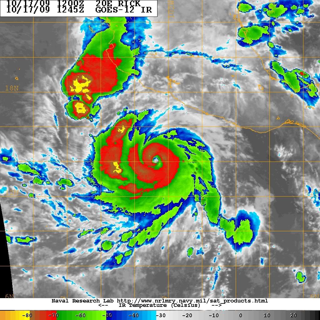
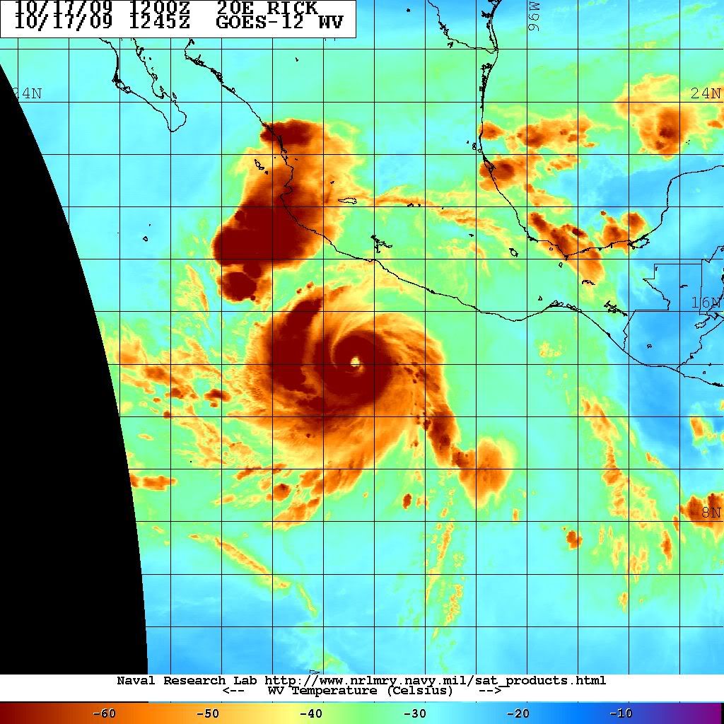
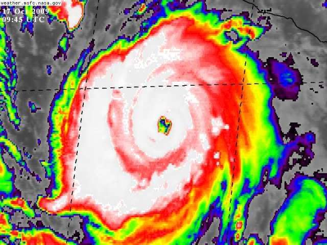
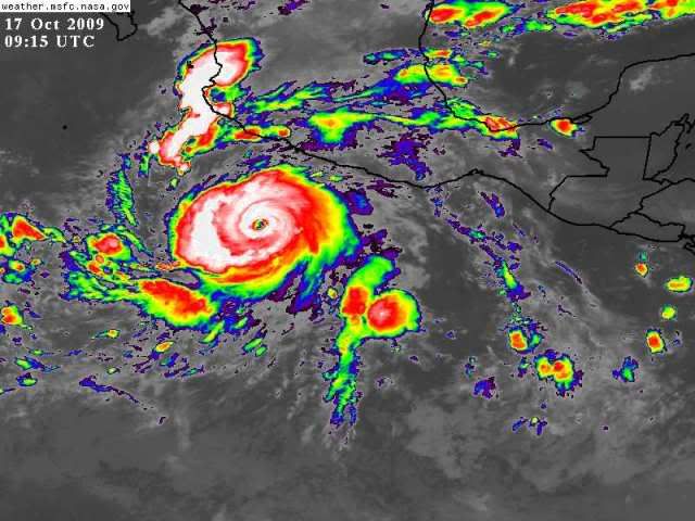
cycloneye wrote:Macrocane,you posted a good site for the observations last night but I found another one this morning to look at the observations in the Mexican coast,island of Socorro and Baja.

http://meteorologia.semar.gob.mx/redemas.php


Great!, thank you. Rick is a beautiful storm and the good thing is that it may weaken before landfall. If the Atlantic doesn't give us something interesting to track there will always be other basins that will do it :wink: By the way, even if it is forecast to weaken before landfall people on Mexico should not let their guard down.
0 likes   

User avatar
cycloneye
Admin
Admin
Posts: 139411
Age: 67
Joined: Thu Oct 10, 2002 10:54 am
Location: San Juan, Puerto Rico

Re: EPAC : HURRICANE RICK (20E)

#133 Postby cycloneye » Sat Oct 17, 2009 9:15 am

First visible image.

Image
0 likes   
Visit the Caribbean-Central America Weather Thread where you can find at first post web cams,radars
and observations from Caribbean basin members Click Here

CrazyC83
Professional-Met
Professional-Met
Posts: 33393
Joined: Tue Mar 07, 2006 11:57 pm
Location: Deep South, for the first time!

#134 Postby CrazyC83 » Sat Oct 17, 2009 9:17 am

UW - CIMSS
ADVANCED DVORAK TECHNIQUE
ADT-Version 7.2.3
Tropical Cyclone Intensity Algorithm

----- Current Analysis -----
Date : 17 OCT 2009 Time : 131500 UTC
Lat : 14:07:12 N Lon : 102:52:53 W


CI# /Pressure/ Vmax
6.5 / 938.1mb/127.0kt


Final T# Adj T# Raw T#
(3hr avg)
6.5 6.6 6.8

Latitude bias adjustment to MSLP : +3.1mb

Estimated radius of max. wind based on IR : 16 km

Center Temp : +1.5C Cloud Region Temp : -71.7C

Scene Type : EYE

Positioning Method : RING/SPIRAL COMBINATION

Ocean Basin : EAST PACIFIC
Dvorak CI > MSLP Conversion Used : ATLANTIC

Tno/CI Rules : Constraint Limits : 2.7T/12hr
Weakening Flag : OFF
Rapid Dissipation Flag : OFF
0 likes   

CrazyC83
Professional-Met
Professional-Met
Posts: 33393
Joined: Tue Mar 07, 2006 11:57 pm
Location: Deep South, for the first time!

#135 Postby CrazyC83 » Sat Oct 17, 2009 9:22 am

Would the Raw T# be a decent estimate given the rapid intensification? Otherwise, the ADT seems the best guess as it has bombed out faster than normal Dvorak constraints allow. I would go with 125 kt for the intensity.
0 likes   

User avatar
cycloneye
Admin
Admin
Posts: 139411
Age: 67
Joined: Thu Oct 10, 2002 10:54 am
Location: San Juan, Puerto Rico

Re: EPAC : HURRICANE RICK (20E)

#136 Postby cycloneye » Sat Oct 17, 2009 9:28 am

Possible Recon on Monday Afternoon

NOUS42 KNHC 171430
WEATHER RECONNAISSANCE FLIGHTS
CARCAH, NATIONAL HURRICANE CENTER, MIAMI, FL.
1030 AM EDT SAT 17 OCTOBER 2009
SUBJECT: TROPICAL CYCLONE PLAN OF THE DAY (TCPOD)
VALID 18/1100Z TO 19/1100Z 0CTOBER 2009
TCPOD NUMBER.....09-142

I. ATLANTIC REQUIREMENTS
1. NEGATIVE RECONNAISSANCE REQUIREMENTS.
2. SUCCEEDING DAY OUTLOOK......NEGATIVE.

II. PACIFIC REQUIREMENTS
1. NEGATIVE RECONNAISSANCE REQUIREMENTS.
2. OUTLOOK FOR SUCCEEDING DAY: PSBL FIX MISSION
ON HURRICANE RICK 19/1800Z NEAR 17.6N AND 111.6W
.

http://www.nhc.noaa.gov/text/MIAREPRPD.shtml?
0 likes   
Visit the Caribbean-Central America Weather Thread where you can find at first post web cams,radars
and observations from Caribbean basin members Click Here

CrazyC83
Professional-Met
Professional-Met
Posts: 33393
Joined: Tue Mar 07, 2006 11:57 pm
Location: Deep South, for the first time!

#137 Postby CrazyC83 » Sat Oct 17, 2009 9:36 am

Once that large ring of convection can completely wrap around the eye (almost there), I think Cat 5 is clearly within reach.
0 likes   

User avatar
cycloneye
Admin
Admin
Posts: 139411
Age: 67
Joined: Thu Oct 10, 2002 10:54 am
Location: San Juan, Puerto Rico

Re: EPAC : HURRICANE RICK (20E)

#138 Postby cycloneye » Sat Oct 17, 2009 9:38 am

WTPZ35 KNHC 171436
TCPEP5
BULLETIN
HURRICANE RICK ADVISORY NUMBER 9
NWS TPC/NATIONAL HURRICANE CENTER MIAMI FL EP202009
800 AM PDT SAT OCT 17 2009

...EXTREMELY DANGEROUS HURRICANE RICK CONTINUING TO STRENGTHEN...

AT 800 AM PDT...1500 UTC...THE CENTER OF HURRICANE RICK WAS LOCATED
NEAR LATITUDE 14.2 NORTH...LONGITUDE 103.0 WEST OR ABOUT 280 MILES
...450 KM...SOUTHWEST OF ACAPULCO MEXICO AND ABOUT 345 MILES...
550 KM...SOUTH-SOUTHEAST OF MANZANILLO MEXICO.

RICK IS MOVING TOWARD THE WEST-NORTHWEST NEAR 12 MPH...19 KM/HR...
AND THIS MOTION IS EXPECTED TO CONTINUE FOR THE NEXT COUPLE OF DAYS.
ON THE FORECAST TRACK...THE CORE OF RICK IS EXPECTED TO REMAIN
OFFSHORE OF THE SOUTHERN COAST OF MEXICO OVER THE WEEKEND AS THE
HURRICANE MOVES GENERALLY PARALLEL TO THE COAST.

MAXIMUM SUSTAINED WINDS ARE NEAR 145 MPH...230 KM/HR...WITH HIGHER
GUSTS. THIS MAKES RICK AN EXTREMELY DANGEROUS CATEGORY FOUR
HURRICANE ON THE SAFFIR-SIMPSON SCALE. ADDITIONAL STRENGTHENING IS
FORECAST...AND RICK COULD BECOME A CATEGORY FIVE HURRICANE LATER
TODAY OR TONIGHT.

HURRICANE FORCE WINDS EXTEND OUTWARD UP TO 40 MILES...65 KM...FROM
THE CENTER...AND TROPICAL STORM FORCE WINDS EXTEND OUTWARD UP TO
115 MILES...185 KM.

ESTIMATED MINIMUM CENTRAL PRESSURE IS 938 MB...27.70 INCHES.

LARGE SWELLS GENERATED BY RICK MAY AFFECT PORTIONS OF THE SOUTHERN
COAST OF MEXICO DURING THE NEXT COUPLE OF DAYS...CAUSING
POTENTIALLY DANGEROUS SURF CONDITIONS.

OUTER RAINBANDS ASSOCIATED WITH RICK WILL CONTINUE TO AFFECT THE
SOUTHERN COAST OF MEXICO THROUGH TONIGHT.

...SUMMARY OF 800 AM PDT INFORMATION...
LOCATION...14.2N 103.0W
MAXIMUM SUSTAINED WINDS...145 MPH
PRESENT MOVEMENT...WEST-NORTHWEST OR 290 DEGREES AT 12 MPH
MINIMUM CENTRAL PRESSURE...938 MB

THE NEXT ADVISORY WILL BE ISSUED BY THE NATIONAL HURRICANE CENTER AT
200 PM PDT.

$$
FORECASTER BEVEN


Image
0 likes   
Visit the Caribbean-Central America Weather Thread where you can find at first post web cams,radars
and observations from Caribbean basin members Click Here

RL3AO
Moderator-Pro Met
Moderator-Pro Met
Posts: 16308
Joined: Thu Jun 14, 2007 10:03 pm
Location: NC

#139 Postby RL3AO » Sat Oct 17, 2009 9:40 am

FORECAST VALID 18/1200Z 15.3N 107.4W
MAX WIND 140 KT...GUSTS 170 KT.
0 likes   

User avatar
cycloneye
Admin
Admin
Posts: 139411
Age: 67
Joined: Thu Oct 10, 2002 10:54 am
Location: San Juan, Puerto Rico

Re: EPAC : HURRICANE RICK (20E)=8 AM PDT Advisory=125kts

#140 Postby cycloneye » Sat Oct 17, 2009 9:47 am

Discussion is not out yet.It should be a long one.
0 likes   
Visit the Caribbean-Central America Weather Thread where you can find at first post web cams,radars
and observations from Caribbean basin members Click Here


Return to “2009”

Who is online

Users browsing this forum: No registered users and 14 guests