ATL: TROPICAL DEPRESSION ANA (02L)
Moderator: S2k Moderators
-
Evil Jeremy

- S2K Supporter

- Posts: 5463
- Age: 32
- Joined: Mon Apr 10, 2006 2:10 pm
- Location: Los Angeles, CA

Re:
Gustywind wrote:Can someone put the latest models, plots for Anna please?
Us in the islands are always monitor Anna as the Leewards and Northern Leew could be hit by this feature.
Tkanks my US friends
here is the link for you my friend, it is updated with each model run. Be sure to click the storm # for the storm you are interested in if there is more than one out there such as right now we have 2 - Ana and Bill
which are storm 2 and storm 3, respectively. The 100 storms seem to be those in the Pacific and storm 50 and storm 90 are those that are running before they actually become storms, so you will have no need to look at those either at this point.
https://my.sfwmd.gov/portal/page?_pagei ... ema=PORTAL
0 likes

-
HurricaneRobert
- Category 3

- Posts: 812
- Joined: Fri May 18, 2007 9:31 pm
Re: ATL: TROPICAL STORM ANA (Models)
Could it meet the same fate that Chris did a couple of years ago? Will there be wind shear north of Hispaniola?
0 likes
-
DanKellFla

- Category 5

- Posts: 1291
- Joined: Fri Mar 17, 2006 12:02 pm
- Location: Lake Worth, Florida
-
storms NC

- Tropical Storm

- Posts: 247
- Age: 70
- Joined: Tue Sep 14, 2004 2:41 pm
- Location: Coast of NC & southwest coast of Fla
Re: ATL : TROPICAL STORM ANA (02L)
wxman57 wrote:Every advisory has shifted the track to the left. No reason to think that'll stop now.
This happens with most storms. It will go to the left for a few runs then a shift back to the right for a few runs. Then when they get all the ducks in a row it will very close. I can just about bet you they will move it back Sunday to the right.
It is going to be up to the ULL if it move either way to the west then the track will move more to the left. If it moves east or North east the track will move back to the right. The Ull is in control of Ana track cause she is weak.
I don't think Ana will make it pass the ULL. I think it will tear her apart. It all come down to what she does tonight and Sunday.
But the upper Islands need to do what they need to do now. But some don't have much to do with. For them I worry over. We can run to the next state. Where are they going to go? All they can do is their best. But you know If I had money I would move down to the virgin Islands in a heart beat
0 likes
-
Bailey1777
- S2K Supporter
- Posts: 962
- Joined: Mon Jul 31, 2006 6:23 pm
- Location: Houston, Texas
-
senorpepr

- Military Met/Moderator

- Posts: 12542
- Age: 43
- Joined: Fri Aug 22, 2003 9:22 pm
- Location: Mackenbach, Germany
- Contact:
UZNT13 KWBC 152112
XXAA 65212 99125 70550 04225 99011 27644 ///// 00093 26839 04012
92778 21432 05510 85507 16833 10509 70146 09464 04508 50586 03793
06011 40759 15985 06519 30969 29982 07005 25096 41380 12515 20243
535// 15011 88999 77999
31313 09608 82049
61616 NOAA9 WX02A ANA OB 01
62626 SPL 1251N05501W 2103 LST WND 015 MBL WND 04012 AEV 20801 DL
M WND 08008 009176 WL150 04512 088 REL 1252N05498W 204915 SPG 125
1N05501W 210301 =
XXBB 65218 99125 70550 04225 00011 27644 11955 23019 22850 16833
33827 15242 44804 17063 55770 15070 66727 12067 77666 07064 88649
05659 99622 02865 11595 02093 22544 00896 33439 10588 44299 30182
55228 46780 66176 59541
21212 00011 ///// 11009 05013 22989 03512 33950 03512 44850 10509
55814 12010 66800 07513 77770 04518 88742 06012 99714 05510 11656
36003 22641 31510 33611 30521 44601 30020 55588 31510 66558 06003
77436 08018 88407 06520 99363 07015 11316 09503 22282 13511 33241
12014 44234 14010 55218 11512 66196 16010
31313 09608 82049
61616 NOAA9 WX02A ANA OB 01
62626 SPL 1251N05501W 2103 LST WND 015 MBL WND 04012 AEV 20801 DL
M WND 08008 009176 WL150 04512 088 REL 1252N05498W 204915 SPG 125
1N05501W 210301 =
0 likes
-
paintplaye
- Category 1

- Posts: 380
- Joined: Sun Jul 20, 2008 11:25 pm
Re:
Bailey1777 wrote:If Ana enters the GOM still intact where would the steering currents most likely take her give or take 200 miles?
No one knows. It is really hard to guess what the steering currents will be when it enters the gulf. It depends on how strong the ridge is and if there are any troughs that are coming down. The stronger the ridge, the farther west it will go.
0 likes
-
HouTXmetro

- Category 5
- Posts: 3949
- Joined: Sun Jun 13, 2004 6:00 pm
- Location: District of Columbia, USA
Re:
Bailey1777 wrote:If Ana enters the GOM still intact where would the steering currents most likely take her give or take 200 miles?
Who knows, right now the entire Northern/Northwestern Gulf is at risk.
0 likes
-
hurricanefloyd5

- Category 5
- Posts: 1659
- Age: 45
- Joined: Sun May 02, 2004 10:53 am
- Location: Spartanburg
- Contact:
Re: ATL: TROPICAL STORM ANA (02L)
AREA FORECAST DISCUSSION
NATIONAL WEATHER SERVICE MELBOURNE FL
245 PM EDT SAT AUG 15 2009
WED-SAT...
LATE WEEK FORECAST VERY DEPENDENT ON EVENTUAL TRACK AND INTENSITY OF
TC ANA. THE GFS DOES NOT SEEM IMPRESSED AND KEEPS "ANA" AN OPEN
TROPICAL WAVE. NEVERTHELESS...HAVE FAIRLY HIGH CONFIDENCE THAT RAIN
CHANCES WILL BE ON THE INCREASE WED AND ESP THU.
0 likes
-
Evil Jeremy
- S2K Supporter
- Posts: 5463
- Age: 32
- Joined: Mon Apr 10, 2006 2:10 pm
- Location: Los Angeles, CA
-
Bailey1777
- S2K Supporter
- Posts: 962
- Joined: Mon Jul 31, 2006 6:23 pm
- Location: Houston, Texas
Re:
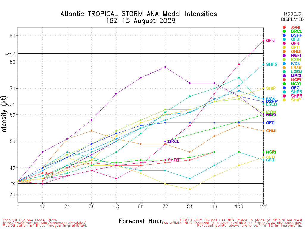
Evil Jeremy wrote:Isnt the GFS the basis for some of the other computer models? And since the GFS looses Ana as a storm within a couple frames, wouldnt that effect some of the other models that are based on the GFS?
Not really, as the GFDL/HWRF use the GFS for initial conditions (and, if I'm not mistaken, only for the outer grid/boundary). BAMs use it to generate steering currents. SHIPS may be somewhat affected because it uses the GFS vortex for an input or two, but that's about it.
0 likes
-
lonelymike
- S2K Supporter
- Posts: 634
- Joined: Sat Jul 26, 2008 10:12 am
- Location: walton county fla
Re: ATL : TROPICAL STORM ANA (02L)
wxman57 wrote:Evil Jeremy wrote:wxman57 wrote:Every advisory has shifted the track to the left. No reason to think that'll stop now.
What do you think the chances are now that this will impact SFL, or is is still to soon to tell?
If I were you, I wouldn't be too worried about Ana. It's sacrificing itself for Bill (and Claudette).
There's your pro opinion
0 likes
-
storms NC
- Tropical Storm
- Posts: 247
- Age: 70
- Joined: Tue Sep 14, 2004 2:41 pm
- Location: Coast of NC & southwest coast of Fla
Re:
Bailey1777 wrote:If Ana enters the GOM still intact where would the steering currents most likely take her give or take 200 miles?
Once it gets past the DP it will be any ones guess JIMO.
Looking at this loop I would say from Cuba to the west or eastern seaboard of Fla.
http://www.ssd.noaa.gov/goes/east/tatl/loop-wv.html
0 likes
-
Bailey1777
- S2K Supporter
- Posts: 962
- Joined: Mon Jul 31, 2006 6:23 pm
- Location: Houston, Texas
I think some are writing Ana off prematurely. It is not a destroyed system and there are surely no gaurantees that she will be shredded by land masses. I would not be suprised to see her wrap up into a small but powerful storm.
Last edited by Bailey1777 on Sat Aug 15, 2009 5:04 pm, edited 1 time in total.
0 likes


-
srainhoutx

- S2K Supporter
- Posts: 6919
- Age: 68
- Joined: Sun Jan 14, 2007 11:34 am
- Location: Haywood County, NC
- Contact:
Who is online
Users browsing this forum: No registered users and 42 guests