EPAC : Tropical Depression (01E)

Moderator: S2k Moderators

Message
Author
User avatar
HURAKAN
Professional-Met
Professional-Met
Posts: 46086
Age: 37
Joined: Thu May 20, 2004 4:34 pm
Location: Key West, FL
Contact:

#21 Postby HURAKAN » Tue Jun 16, 2009 3:05 pm

Image

It's semi-exposed but it looks quite good.
0 likes   

User avatar
HURAKAN
Professional-Met
Professional-Met
Posts: 46086
Age: 37
Joined: Thu May 20, 2004 4:34 pm
Location: Key West, FL
Contact:

Re: EPAC : Invest 92E

#22 Postby HURAKAN » Tue Jun 16, 2009 3:05 pm

316
WHXX01 KMIA 161835
CHGE77
TROPICAL CYCLONE GUIDANCE MESSAGE
NWS TPC/NATIONAL HURRICANE CENTER MIAMI FL
1835 UTC TUE JUN 16 2009

DISCLAIMER...NUMERICAL MODELS ARE SUBJECT TO LARGE ERRORS.
PLEASE REFER TO NHC OFFICIAL FORECASTS FOR TROPICAL CYCLONE
AND SUBTROPICAL CYCLONE INFORMATION.

EAST PACIFIC OBJECTIVE AIDS FOR

DISTURBANCE INVEST (EP922009) 20090616 1800 UTC

...00 HRS... ...12 HRS... ...24 HRS. .. ...36 HRS...
090616 1800 090617 0600 090617 1800 090618 0600

LAT LON LAT LON LAT LON LAT LON
BAMS 14.3N 105.3W 15.1N 106.9W 16.0N 108.7W 16.9N 110.3W
BAMD 14.3N 105.3W 14.9N 106.9W 15.8N 108.3W 16.9N 109.3W
BAMM 14.3N 105.3W 15.1N 107.2W 16.0N 109.0W 17.0N 110.5W
LBAR 14.3N 105.3W 15.1N 106.8W 16.1N 108.4W 17.5N 109.9W
SHIP 25KTS 27KTS 31KTS 37KTS
DSHP 25KTS 27KTS 31KTS 37KTS

...48 HRS... ...72 HRS... ...96 HRS. .. ..120 HRS...
090618 1800 090619 1800 090620 1800 090621 1800

LAT LON LAT LON LAT LON LAT LON
BAMS 17.8N 111.4W 19.2N 111.8W 20.1N 111.6W 20.2N 111.9W
BAMD 18.2N 110.0W 22.0N 109.5W 27.2N 108.6W 33.3N 106.1W
BAMM 18.0N 111.5W 20.4N 111.0W 23.1N 110.6W 25.3N 110.8W
LBAR 19.0N 111.0W 22.5N 112.2W 28.2N 111.9W 35.5N 107.2W
SHIP 41KTS 41KTS 32KTS 25KTS
DSHP 41KTS 41KTS 32KTS 26KTS

...INITIAL CONDITIONS...
LATCUR = 14.3N LONCUR = 105.3W DIRCUR = 285DEG SPDCUR = 7KT
LATM12 = 14.0N LONM12 = 103.8W DIRM12 = 288DEG SPDM12 = 7KT
LATM24 = 13.5N LONM24 = 101.7W
WNDCUR = 25KT RMAXWD = 75NM WNDM12 = 25KT
CENPRS = 1008MB OUTPRS = 1010MB OUTRAD = 150NM SDEPTH = M
RD34NE = 0NM RD34SE = 0NM RD34SW = 0NM RD34NW = 0NM


Image
0 likes   

User avatar
HURAKAN
Professional-Met
Professional-Met
Posts: 46086
Age: 37
Joined: Thu May 20, 2004 4:34 pm
Location: Key West, FL
Contact:

#23 Postby HURAKAN » Tue Jun 16, 2009 3:16 pm

Image
0 likes   

User avatar
cycloneye
Admin
Admin
Posts: 139407
Age: 67
Joined: Thu Oct 10, 2002 10:54 am
Location: San Juan, Puerto Rico

Re: EPAC : Invest 92E

#24 Postby cycloneye » Tue Jun 16, 2009 4:06 pm

Center continues to be exposed.

Image
0 likes   

User avatar
KWT
Category 5
Category 5
Posts: 31391
Joined: Tue Aug 17, 2004 11:02 am
Location: UK!!!

#25 Postby KWT » Tue Jun 16, 2009 4:22 pm

Convection seems to be weakening a little bit, though thats not surprising given we are heading further into the day. D-min tomorrow will be very interesting.
0 likes   

User avatar
Macrocane
Category 5
Category 5
Posts: 4218
Age: 35
Joined: Sun May 24, 2009 5:35 pm
Location: El Salvador

Re: EPAC : Invest 92E

#26 Postby Macrocane » Tue Jun 16, 2009 5:15 pm

This time I'm not going to say that it's already a tropical cyclone, but it has some potential. If the convection flares up again later and the shear keeps the same or relaxes then I will give a second thought, but now I'll wait.
0 likes   

User avatar
Cookie
S2K Supporter
S2K Supporter
Posts: 477
Age: 36
Joined: Sun Dec 14, 2008 11:13 am
Location: Isle Of lewis scotland

#27 Postby Cookie » Tue Jun 16, 2009 5:18 pm

I agree about the waiting. to many these have started to look good and fallen flat very fast
0 likes   

User avatar
KWT
Category 5
Category 5
Posts: 31391
Joined: Tue Aug 17, 2004 11:02 am
Location: UK!!!

#28 Postby KWT » Tue Jun 16, 2009 5:49 pm

Center seems to be once more becoming exposed as the convection decays somewhat to its SW. Just got to wait for the next burst to come along which it will at some point soon given there is a lot of energy with the system and the general region.
0 likes   

RL3AO
Moderator-Pro Met
Moderator-Pro Met
Posts: 16308
Joined: Thu Jun 14, 2007 10:03 pm
Location: NC

#29 Postby RL3AO » Tue Jun 16, 2009 5:57 pm

Center is exposed, but it is moving into an area of lower shear according to CIMSS.

Image
0 likes   

User avatar
srainhoutx
S2K Supporter
S2K Supporter
Posts: 6919
Age: 66
Joined: Sun Jan 14, 2007 11:34 am
Location: Haywood County, NC
Contact:

Re: EPAC : Invest 92E

#30 Postby srainhoutx » Tue Jun 16, 2009 6:04 pm

Please, just send some of the moisture to TX and end this "death ridge".
0 likes   

User avatar
KWT
Category 5
Category 5
Posts: 31391
Joined: Tue Aug 17, 2004 11:02 am
Location: UK!!!

#31 Postby KWT » Tue Jun 16, 2009 6:06 pm

Yeah shear does seem to be lower close by according to that, I think the reason it has become more exposed again is simply because the convection is decaying nearby it, interestingly at the same time convection to its east is becoming much more widespread.
0 likes   

User avatar
cycloneye
Admin
Admin
Posts: 139407
Age: 67
Joined: Thu Oct 10, 2002 10:54 am
Location: San Juan, Puerto Rico

Re: EPAC : Invest 92E

#32 Postby cycloneye » Tue Jun 16, 2009 6:41 pm

Before it gets dark look where the center is.

Image

http://rammb.cira.colostate.edu/ramsdis ... opical.asp
0 likes   

User avatar
cycloneye
Admin
Admin
Posts: 139407
Age: 67
Joined: Thu Oct 10, 2002 10:54 am
Location: San Juan, Puerto Rico

Re: EPAC : Invest 92E

#33 Postby cycloneye » Tue Jun 16, 2009 6:43 pm

Still at Code Red

616
ABPZ20 KNHC 162341
TWOEP
TROPICAL WEATHER OUTLOOK
NWS TPC/NATIONAL HURRICANE CENTER MIAMI FL
500 PM PDT TUE JUN 16 2009

FOR THE EASTERN NORTH PACIFIC...EAST OF 140 DEGREES WEST LONGITUDE..

SHOWERS AND THUNDERSTORMS ASSOCIATED WITH AN AREA OF LOW PRESSURE
LOCATED ABOUT 350 MILES SOUTH-SOUTHWEST OF MANZANILLO MEXICO HAVE
CHANGED LITTLE IN ORGANIZATION DURING THE PAST SEVERAL HOURS. THIS
SYSTEM HAS THE POTENTIAL TO BECOME A TROPICAL DEPRESSION DURING THE
NEXT DAY OR TWO AS IT MOVES SLOWLY WEST-NORTHWESTWARD. THERE IS A
HIGH CHANCE...GREATER THAN 50 PERCENT...OF THIS SYSTEM BECOMING A
TROPICAL CYCLONE DURING THE NEXT 48 HOURS.

ELSEWHERE...TROPICAL CYCLONE FORMATION IS NOT EXPECTED DURING THE
NEXT 48 HOURS.

$$
FORECASTER BEVEN


0 likes   

User avatar
KWT
Category 5
Category 5
Posts: 31391
Joined: Tue Aug 17, 2004 11:02 am
Location: UK!!!

#34 Postby KWT » Tue Jun 16, 2009 6:56 pm

Lttle surprised they left it at code red given the convection has decreased a fair amount right next to the LLC and the LLC has got exposed as well it seems.

Still one big burst will have this system going again.
Also notice the convection developing to the east, sure sign the shear is easing off as well as shifting vector it seems.
0 likes   

Derek Ortt

#35 Postby Derek Ortt » Tue Jun 16, 2009 7:47 pm

we;re downplaying it somewhat this evening, but it has some chance of developing over the next couple of days as conditions are expected to improve
0 likes   

User avatar
HURAKAN
Professional-Met
Professional-Met
Posts: 46086
Age: 37
Joined: Thu May 20, 2004 4:34 pm
Location: Key West, FL
Contact:

Re: EPAC : Invest 92E

#36 Postby HURAKAN » Tue Jun 16, 2009 9:12 pm

Image

Image
0 likes   

User avatar
HURAKAN
Professional-Met
Professional-Met
Posts: 46086
Age: 37
Joined: Thu May 20, 2004 4:34 pm
Location: Key West, FL
Contact:

#37 Postby HURAKAN » Tue Jun 16, 2009 9:40 pm

Image
0 likes   

User avatar
Andrew92
S2K Supporter
S2K Supporter
Posts: 3247
Age: 40
Joined: Mon Jun 16, 2003 12:35 am
Location: Phoenix, Arizona

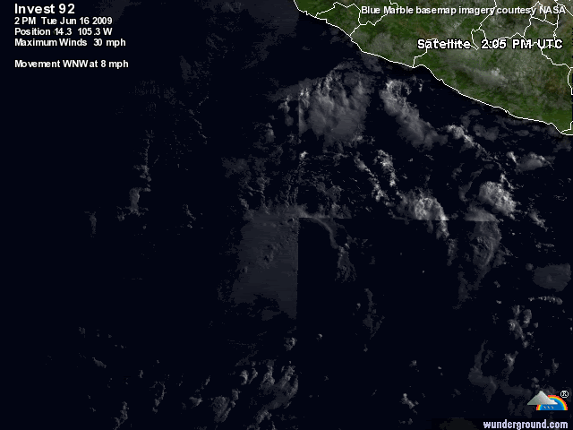
#38 Postby Andrew92 » Tue Jun 16, 2009 10:46 pm

If this little guy decides to develop further, could this become a concern in terms of flooding where I live in Phoenix? I see that three models take this thing much further to the north, although I do know that the LBAR isn't the sharpest tool in the shed and the BAMM isn't that great for deeper systems.

How reliable is the HWRF for systems like this? It looks like that model makes this think into a decent storm. Does that yellow box in the Gulf of California indicate they think this disturbance might form into a hurricane if it heads up there?

I'm just naturally concerned that flooding might hit my city, plus I may be going hiking in the mountains this weekend.

-Andrew92
0 likes   

User avatar
HURAKAN
Professional-Met
Professional-Met
Posts: 46086
Age: 37
Joined: Thu May 20, 2004 4:34 pm
Location: Key West, FL
Contact:

#39 Postby HURAKAN » Wed Jun 17, 2009 1:41 am

:uarrow: In my opinion, keep an eye on it!

TROPICAL WEATHER OUTLOOK
NWS TPC/NATIONAL HURRICANE CENTER MIAMI FL
1100 PM PDT TUE JUN 16 2009

FOR THE EASTERN NORTH PACIFIC...EAST OF 140 DEGREES WEST LONGITUDE..

SHOWERS AND THUNDERSTORMS ASSOCIATED WITH AN AREA OF LOW PRESSURE
LOCATED ABOUT 350 MILES SOUTH-SOUTHWEST OF MANZANILLO MEXICO
CONTINUE TO SHOW SIGNS OF ORGANIZATION. THIS SYSTEM HAS THE
POTENTIAL TO BECOME A TROPICAL DEPRESSION DURING THE NEXT DAY OR
TWO AS IT MOVES SLOWLY WEST-NORTHWESTWARD. THERE IS A HIGH
CHANCE...GREATER THAN 50 PERCENT...OF THIS SYSTEM BECOMING A
TROPICAL CYCLONE DURING THE NEXT 48 HOURS.

ELSEWHERE...TROPICAL CYCLONE FORMATION IS NOT EXPECTED DURING THE
NEXT 48 HOURS.

$$
FORECASTER BEVEN
0 likes   

User avatar
HURAKAN
Professional-Met
Professional-Met
Posts: 46086
Age: 37
Joined: Thu May 20, 2004 4:34 pm
Location: Key West, FL
Contact:

#40 Postby HURAKAN » Wed Jun 17, 2009 1:47 am

0 likes   


Return to “2009”

Who is online

Users browsing this forum: No registered users and 6 guests