EAST COAST : Tropical Depression ONE
Moderator: S2k Moderators
-
wxman57

- Moderator-Pro Met

- Posts: 23172
- Age: 68
- Joined: Sat Jun 21, 2003 8:06 pm
- Location: Houston, TX (southwest)
Re: EAST COAST : Tropical Depression ONE
Just comparing its appearance now vs. this morning, it looks no better organized. In fact, tops have been warming for the past few hours, an indication of weakening. So perhaps it already reached its peak. I can't see naming it without evidence of 39 mph winds, with convection decreasing, and the center not being beneath the convection.
0 likes
-
HURAKAN

- Professional-Met

- Posts: 46084
- Age: 39
- Joined: Thu May 20, 2004 4:34 pm
- Location: Key West, FL
- Contact:
Re: EAST COAST : Tropical Depression ONE
UW - CIMSS
ADVANCED DVORAK TECHNIQUE
ADT-Version 7.2.3
Tropical Cyclone Intensity Algorithm
----- Current Analysis -----
Date : 28 MAY 2009 Time : 171500 UTC
Lat : 37:30:56 N Lon : 70:30:16 W
CI# /Pressure/ Vmax
1.8 /1010.2mb/ 28.0kt
Final T# Adj T# Raw T#
(3hr avg)
1.8 2.1 2.7
Latitude bias adjustment to MSLP : +0.0mb
Center Temp : -51.7C Cloud Region Temp : -37.9C
Scene Type : UNIFORM CDO CLOUD REGION
Positioning Method : FORECAST INTERPOLATION
Ocean Basin : ATLANTIC
Dvorak CI > MSLP Conversion Used : ATLANTIC
Tno/CI Rules : Constraint Limits : 0.2T/hour
Weakening Flag : OFF
Rapid Dissipation Flag : OFF
****************************************************
0 likes
-
Category 5

- Category 5

- Posts: 10074
- Age: 36
- Joined: Sun Feb 11, 2007 10:00 pm
- Location: New Brunswick, NJ
- Contact:
Re: EAST COAST : Tropical Depression ONE
This was absolutely nothing yesterday, just goes to show ya.
This is why I'm a met major. Never a dull moment.
This is why I'm a met major. Never a dull moment.
0 likes
-
Evil Jeremy

- S2K Supporter

- Posts: 5463
- Age: 32
- Joined: Mon Apr 10, 2006 2:10 pm
- Location: Los Angeles, CA
Re: EAST COAST : Tropical Depression ONE
I was taking my History exam this morning, and while I was trying to concentrate on Germany in World War II, my teacher, who knows I love the weather, comes out and says we have our first Tropical Depression. I hated that lol.
0 likes
-
wyq614

- Category 3

- Posts: 827
- Age: 37
- Joined: Sun Dec 02, 2007 12:32 am
- Location: Beijing, China (Hometown: Qingdao, China, 36.06N 120.43E)
- Contact:
We are human beings, no gods, no computers, and even gods and computers may fail. We all know that TC forecast is not an easy thing. Let's stop blaming the pro mets, something unusual always occurs. But anyway, we should respect all the opinions, professional or non-professional and no matter whether it sounds strange or not. "little chance", "dead" should not be easy words.
Back to TD 1, as an Asian, I may know little about the climatology of North Atlantic, but I personally think it is hard for the system to be named even with the aid of Gulf Stream and low wind shear, and it is being ejected to the NE with a moderate to high speed, it should have a slight chance to be named in the #2, if it still can't make it in #2, Ana will remain in the lista de espera.
Back to TD 1, as an Asian, I may know little about the climatology of North Atlantic, but I personally think it is hard for the system to be named even with the aid of Gulf Stream and low wind shear, and it is being ejected to the NE with a moderate to high speed, it should have a slight chance to be named in the #2, if it still can't make it in #2, Ana will remain in the lista de espera.
0 likes
-
TropicalWXMA

- Tropical Storm

- Posts: 114
- Joined: Wed May 18, 2005 9:22 pm
- Location: Boston, MA
- Contact:


-
cycloneye

- Admin

- Posts: 149276
- Age: 69
- Joined: Thu Oct 10, 2002 10:54 am
- Location: San Juan, Puerto Rico
Re: EAST COAST : Tropical Depression ONE
ADVANCED DVORAK TECHNIQUE
ADT-Version 7.2.3
Tropical Cyclone Intensity Algorithm
----- Current Analysis -----
Date : 28 MAY 2009 Time : 174500 UTC
Lat : 37:34:16 N Lon : 70:22:50 W
CI# /Pressure/ Vmax
1.9 /1009.6mb/ 29.0kt
Final T# Adj T# Raw T#
(3hr avg)
1.9 2.3 2.7
Latitude bias adjustment to MSLP : +0.0mb
Center Temp : -49.3C Cloud Region Temp : -37.7C
Scene Type : UNIFORM CDO CLOUD REGION
Positioning Method : FORECAST INTERPOLATION
Ocean Basin : ATLANTIC
Dvorak CI > MSLP Conversion Used : ATLANTIC
Tno/CI Rules : Constraint Limits : 0.2T/hour
Weakening Flag : OFF
Rapid Dissipation Flag : OFF
http://cimss.ssec.wisc.edu/tropic2/real ... t/adt.html
0 likes
-
cycloneye
- Admin
- Posts: 149276
- Age: 69
- Joined: Thu Oct 10, 2002 10:54 am
- Location: San Juan, Puerto Rico
Re: MODEL GUIDANCE : Tropical Depression ONE
WHXX01 KWBC 281852
CHGHUR
TROPICAL CYCLONE GUIDANCE MESSAGE
NWS TPC/NATIONAL HURRICANE CENTER MIAMI FL
1852 UTC THU MAY 28 2009
DISCLAIMER...NUMERICAL MODELS ARE SUBJECT TO LARGE ERRORS.
PLEASE REFER TO NHC OFFICIAL FORECASTS FOR TROPICAL CYCLONE
AND SUBTROPICAL CYCLONE INFORMATION.
ATLANTIC OBJECTIVE AIDS FOR
TROPICAL CYCLONE ONE (AL012009) 20090528 1800 UTC
...00 HRS... ...12 HRS... ...24 HRS. .. ...36 HRS...
090528 1800 090529 0600 090529 1800 090530 0600
LAT LON LAT LON LAT LON LAT LON
BAMS 37.4N 70.2W 39.2N 67.8W 41.5N 64.6W 44.0N 60.4W
BAMD 37.4N 70.2W 38.8N 66.2W 40.1N 61.4W 41.1N 55.9W
BAMM 37.4N 70.2W 39.0N 67.0W 41.0N 63.2W 43.0N 58.2W
LBAR 37.4N 70.2W 38.7N 66.5W 39.5N 62.1W 39.6N 57.1W
SHIP 30KTS 35KTS 39KTS 41KTS
DSHP 30KTS 35KTS 39KTS 41KTS
...48 HRS... ...72 HRS... ...96 HRS. .. ..120 HRS...
090530 1800 090531 1800 090601 1800 090602 1800
LAT LON LAT LON LAT LON LAT LON
BAMS 46.3N 56.2W 51.5N 52.7W 57.8N 55.9W 62.8N 60.8W
BAMD 41.2N 50.3W 36.9N 42.1W 31.8N 38.0W 29.3N 34.7W
BAMM 44.4N 52.5W 42.6N 44.3W 37.4N 40.6W 32.6N 36.1W
LBAR 38.9N 52.2W 36.1N 44.6W 31.1N 41.4W 25.5N 43.7W
SHIP 43KTS 32KTS 18KTS 0KTS
DSHP 43KTS 32KTS 18KTS 0KTS
...INITIAL CONDITIONS...
LATCUR = 37.4N LONCUR = 70.2W DIRCUR = 50DEG SPDCUR = 13KT
LATM12 = 36.1N LONM12 = 72.9W DIRM12 = 45DEG SPDM12 = 14KT
LATM24 = 34.4N LONM24 = 74.6W
WNDCUR = 30KT RMAXWD = 40NM WNDM12 = 25KT
CENPRS = 1006MB OUTPRS = 1011MB OUTRAD = 100NM SDEPTH = M
RD34NE = 0NM RD34SE = 0NM RD34SW = 0NM RD34NW = 0NM
0 likes
-
tolakram
- Admin
- Posts: 20179
- Age: 62
- Joined: Sun Aug 27, 2006 8:23 pm
- Location: Florence, KY (name is Mark)
Re: EAST COAST : Tropical Depression ONE
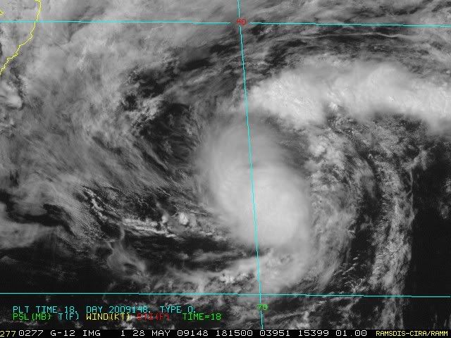
Looks to me like the convection has dramatically decreased and the tops are blowing away. It might have run out of warm water.
http://www.ssd.noaa.gov/goes/flt/t1/flash-rgb.html
http://www.ssd.noaa.gov/goes/flt/t1/flash-rgb.html
0 likes
-
cycloneye
- Admin
- Posts: 149276
- Age: 69
- Joined: Thu Oct 10, 2002 10:54 am
- Location: San Juan, Puerto Rico
Re: EAST COAST : Tropical Depression ONE
18z Best Track update:
AL, 01, 2009052818, , BEST, 0, 374N, 702W, 30, 1006, TD, 34,
ftp://ftp.tpc.ncep.noaa.gov/atcf/tcweb/
AL, 01, 2009052818, , BEST, 0, 374N, 702W, 30, 1006, TD, 34,
ftp://ftp.tpc.ncep.noaa.gov/atcf/tcweb/
0 likes
-
tolakram
- Admin
- Posts: 20179
- Age: 62
- Joined: Sun Aug 27, 2006 8:23 pm
- Location: Florence, KY (name is Mark)
Re: EAST COAST : Tropical Depression ONE
And just like that ... new convection firing.

MIMIC
http://cimss.ssec.wisc.edu/tropic/real- ... npage.html

MIMIC
http://cimss.ssec.wisc.edu/tropic/real- ... npage.html
0 likes
Re: EAST COAST : Tropical Depression ONE
It looks semi-healthy.. wouldn't be surprised if it gets upgraded at 5 or 11.
0 likes

Re: EAST COAST : Tropical Depression ONE
Considering the latitude and water temps, actually looking fairly healthy....appears to have low shear as there is at least the appearance of outflow in most directions as of the latest image. Going to be a td still at 5pm at a minimum.
0 likes
-
cycloneye
- Admin
- Posts: 149276
- Age: 69
- Joined: Thu Oct 10, 2002 10:54 am
- Location: San Juan, Puerto Rico
Re: EAST COAST : Tropical Depression ONE
UW - CIMSS
ADVANCED DVORAK TECHNIQUE
ADT-Version 7.2.3
Tropical Cyclone Intensity Algorithm
----- Current Analysis -----
Date : 28 MAY 2009 Time : 184500 UTC
Lat : 37:41:26 N Lon : 70:07:01 W
CI# /Pressure/ Vmax
2.1 /1008.2mb/ 31.0kt
Final T# Adj T# Raw T#
(3hr avg)
2.1 2.5 3.5
Latitude bias adjustment to MSLP : +0.0mb
Center Temp : -39.8C Cloud Region Temp : -36.2C
Scene Type : CURVED BAND with 0.75 ARC in MD GRAY
Positioning Method : FORECAST INTERPOLATION
Ocean Basin : ATLANTIC
Dvorak CI > MSLP Conversion Used : ATLANTIC
Tno/CI Rules : Constraint Limits : 0.2T/hour
Weakening Flag : OFF
Rapid Dissipation Flag : OFF
0 likes
Who is online
Users browsing this forum: No registered users and 50 guests