WPAC: SEVERE TROPICAL STORM LUPIT (22W)

Moderator: S2k Moderators

Message
Author
oaba09
S2K Supporter
S2K Supporter
Posts: 1496
Age: 38
Joined: Thu Oct 01, 2009 10:02 am
Location: Valenzuela, Philippines
Contact:

Re: Re:

#261 Postby oaba09 » Sun Oct 18, 2009 3:22 am

ricmood wrote:
oaba09 wrote:
ricmood wrote:What's preventing Lupit to go northeast for good???


The trough is not deep enough and I believe the forecasts are saying that the ridge is going to rebuild...


Rebuild somewhere east?


From JTWC:
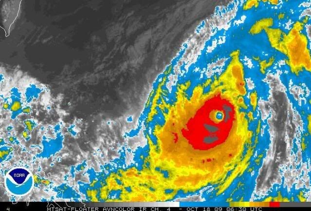
SUPER TYPHOON (STY) 22W (LUPIT), LOCATED APPROXIMATELY 740 NM EAST-
NORTHEAST OF MANILA, PHILIPPINES, HAS TRACKED EAST-NORTHEASTWARD AT
06 KNOTS OVER THE PAST SIX HOURS. ANIMATED MULTISPECTRAL SATELLITE
IMAGERY SHOWS A RAPID IMPROVEMENT IN THE STRUCTURE AND INCREASE IN
SIZE OF THE EYE SUGGESTING THAT THE SYSTEM HAS UNDERGONE A RAPID
INCREASE IN INTENSITY OVER THE PAST 06 HOURS AND IS NOW BEING
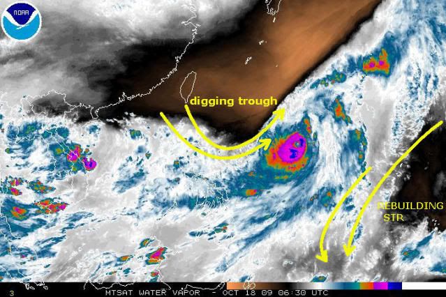
CLASSIFIED AS A SUPER TYPHOON. THE TRACK HAS CONTINUED TO SHIFT TO A
MORE EAST-NORTHEASTWARD DIRECTION UNDER THE INFLUENCE OF THE MID-
LATITUDE TROUGH THAT HAS BEEN NORTH OF LUPIT FOR THE LAST 24 HOURS.
THE TROUGH IS WEAKENING AND MOVING NORTHEASTWARD, AND HAS LED TO A
WEAKENING OF THE MID-LEVEL SUBTROPICAL RIDGE (STR) TO THE EAST OF
LUPIT, AND THE RECENT TRACK CHANGES OBSERVED. THE EXPECTATION IS FOR
STY 22W TO KEEP ON AN EAST-NORTHEASTWARD TRACK FOR THE NEXT 12
HOURS, SLOWLY SHIFTING TO A NORTHWARD TRACK AS THE TROUGH MOVES OUT
AND THE STR TO THE EAST BUILDS. IT APPEARS THAT LUPIT WILL SLOWLY
LOOP BACK TO THE WEST AS A MID-LEVEL STR BUILDS FROM CENTRAL CHINA
OVER THE WESTERN PACIFIC, NORTH OF STY 22W. WITH THE EXCEPTION OF
WBAR AND TCLP, CURRENT MODEL GUIDANCE IS IN GOOD AGREEMENT WITH THIS
SCENARIO. MAXIMUM SIGNIFICANT WAVE HEIGHT AT 180600Z IS 27 FEET.
NEXT WARNINGS AT 181500Z, 182100Z, 190300Z AND 190900Z.//
NNNN
0 likes   

ozonepete
Professional-Met
Professional-Met
Posts: 4743
Joined: Mon Sep 07, 2009 3:23 pm
Location: From Ozone Park, NYC / Now in Brooklyn, NY

Re: WPAC: TYPHOON LUPIT (22W)

#262 Postby ozonepete » Sun Oct 18, 2009 3:28 am

Though the Dvorak numbers around 6.4 are impressive, they don't indicate a super typhoon. And the satellite images certainly don't look like it. The symmetry is really poor for a "super typhoon."

Image
0 likes   

oaba09
S2K Supporter
S2K Supporter
Posts: 1496
Age: 38
Joined: Thu Oct 01, 2009 10:02 am
Location: Valenzuela, Philippines
Contact:

#263 Postby oaba09 » Sun Oct 18, 2009 3:38 am

PAGASA said that this typhoon has 175 kph winds near the center and gistiness of up to 210 kph...Is this accurate?
0 likes   

ozonepete
Professional-Met
Professional-Met
Posts: 4743
Joined: Mon Sep 07, 2009 3:23 pm
Location: From Ozone Park, NYC / Now in Brooklyn, NY

Re: WPAC: TYPHOON LUPIT (22W)

#264 Postby ozonepete » Sun Oct 18, 2009 3:38 am

I am becoming pretty convinced that the forecast track is way off. I now think this will probably recurve to the northeast, but if it doesn't, it has certainly gone way east of where they were forecasting it to. The STR is not rebuilding to the north of the cyclone, but rather to it's south. That's not conducive for a westward turn.

Image
0 likes   

User avatar
erg123
Tropical Low
Tropical Low
Posts: 19
Age: 53
Joined: Sun Oct 11, 2009 1:39 am
Contact:

#265 Postby erg123 » Sun Oct 18, 2009 3:40 am

Image

I look hopefully over cat5
0 likes   
信芭玛,得永生。欢迎外国友人访问http://tieba.baidu.com/f?kw=%CC%A8%B7%E7&fr=ala0

User avatar
erg123
Tropical Low
Tropical Low
Posts: 19
Age: 53
Joined: Sun Oct 11, 2009 1:39 am
Contact:

#266 Postby erg123 » Sun Oct 18, 2009 3:41 am

強 颱 風 盧 碧 已 增 強 為 一 超 強 颱 風 。 在 下 午 四 時 , 盧 碧 集 結 在 馬 尼 拉 之 東 北 偏 東 約 1400 公 里 , 預 料 向 北 或 西 北 偏 北 緩 慢 移 動 , 大 致 移 向 呂 宋 以 東 海 域 。
0 likes   
信芭玛,得永生。欢迎外国友人访问http://tieba.baidu.com/f?kw=%CC%A8%B7%E7&fr=ala0

User avatar
erg123
Tropical Low
Tropical Low
Posts: 19
Age: 53
Joined: Sun Oct 11, 2009 1:39 am
Contact:

#267 Postby erg123 » Sun Oct 18, 2009 3:43 am

Should change late at night about the tonight northwest to the west
0 likes   
信芭玛,得永生。欢迎外国友人访问http://tieba.baidu.com/f?kw=%CC%A8%B7%E7&fr=ala0

User avatar
RattleMan
Category 5
Category 5
Posts: 1218
Joined: Wed Aug 24, 2005 7:14 pm
Location: Phoenix, AZ

Re:

#268 Postby RattleMan » Sun Oct 18, 2009 3:46 am

oaba09 wrote:PAGASA said that this typhoon has 175 kph winds near the center and gistiness of up to 210 kph...Is this accurate?

Depends on whether you use 1- or 10-minute winds.

JTWC 0900z: 241 kph, 296 kph gusts

JMA 0600z: 166 kph, 241 kph gusts
0 likes   

User avatar
drdavisjr
Category 1
Category 1
Posts: 428
Age: 57
Joined: Mon Oct 12, 2009 7:07 am
Location: Marilao, Bulacan, Philippines
Contact:

Re: WPAC: TYPHOON LUPIT (22W)

#269 Postby drdavisjr » Sun Oct 18, 2009 3:48 am

This was added at 3:30 pm from a local enthusiast.

http://weathergaines.blogspot.com/2009/ ... n-and.html

Image
0 likes   

ozonepete
Professional-Met
Professional-Met
Posts: 4743
Joined: Mon Sep 07, 2009 3:23 pm
Location: From Ozone Park, NYC / Now in Brooklyn, NY

Re: WPAC: TYPHOON LUPIT (22W)

#270 Postby ozonepete » Sun Oct 18, 2009 3:57 am

BTW,, from the last JTWC prog reasoning:

MODEL GUIDANCE REMAINS IN FAIR AGREEMENT, WITH THREE NOTABLE EXCEPTIONS: WBAR, TCLAPS AND GFDN KEEPING THE SYSTEM ON A NORTHWARD TRACK AROUND THE STR TO THE NORTHEAST AND INTO THE MIDLATITUDE FLOW.
0 likes   

oaba09
S2K Supporter
S2K Supporter
Posts: 1496
Age: 38
Joined: Thu Oct 01, 2009 10:02 am
Location: Valenzuela, Philippines
Contact:

Re: WPAC: TYPHOON LUPIT (22W)

#271 Postby oaba09 » Sun Oct 18, 2009 4:12 am

ozonepete wrote:I am becoming pretty convinced that the forecast track is way off. I now think this will probably recurve to the northeast, but if it doesn't, it has certainly gone way east of where they were forecasting it to. The STR is not rebuilding to the north of the cyclone, but rather to it's south. That's not conducive for a westward turn.

Image


That will be good news for the Philippines and bad news to wherever the typhoon is heading IF that happens...
0 likes   

oaba09
S2K Supporter
S2K Supporter
Posts: 1496
Age: 38
Joined: Thu Oct 01, 2009 10:02 am
Location: Valenzuela, Philippines
Contact:

#272 Postby oaba09 » Sun Oct 18, 2009 4:13 am

The next movements of Lupit is very critical.....I'm sure people are anxious to see what will happen.....
0 likes   

User avatar
drdavisjr
Category 1
Category 1
Posts: 428
Age: 57
Joined: Mon Oct 12, 2009 7:07 am
Location: Marilao, Bulacan, Philippines
Contact:

Re:

#273 Postby drdavisjr » Sun Oct 18, 2009 4:21 am

oaba09 wrote:The next movements of Lupit is very critical.....I'm sure people are anxious to see what will happen.....


It sure looks like it is getting better for us in the Philippines.
0 likes   

oaba09
S2K Supporter
S2K Supporter
Posts: 1496
Age: 38
Joined: Thu Oct 01, 2009 10:02 am
Location: Valenzuela, Philippines
Contact:

Re: Re:

#274 Postby oaba09 » Sun Oct 18, 2009 4:25 am

drdavisjr wrote:
oaba09 wrote:The next movements of Lupit is very critical.....I'm sure people are anxious to see what will happen.....


It sure looks like it is getting better for us in the Philippines.


Let's hope that it continues that way :D
0 likes   

ozonepete
Professional-Met
Professional-Met
Posts: 4743
Joined: Mon Sep 07, 2009 3:23 pm
Location: From Ozone Park, NYC / Now in Brooklyn, NY

Re: Re:

#275 Postby ozonepete » Sun Oct 18, 2009 4:29 am

oaba09 wrote:
drdavisjr wrote:
oaba09 wrote:The next movements of Lupit is very critical.....I'm sure people are anxious to see what will happen.....


It sure looks like it is getting better for us in the Philippines.


Let's hope that it continues that way :D


Yes, at this point, if it doesn't slow down, your worries are over. :D
0 likes   

ozonepete
Professional-Met
Professional-Met
Posts: 4743
Joined: Mon Sep 07, 2009 3:23 pm
Location: From Ozone Park, NYC / Now in Brooklyn, NY

Re: WPAC: TYPHOON LUPIT (22W)

#276 Postby ozonepete » Sun Oct 18, 2009 4:42 am

mabuti
0 likes   

User avatar
drdavisjr
Category 1
Category 1
Posts: 428
Age: 57
Joined: Mon Oct 12, 2009 7:07 am
Location: Marilao, Bulacan, Philippines
Contact:

Re: WPAC: TYPHOON LUPIT (22W)

#277 Postby drdavisjr » Sun Oct 18, 2009 4:42 am

Image

To my eye, that looks like a nice path up to the northeast :D
0 likes   

beaufort12
S2K Supporter
S2K Supporter
Posts: 70
Joined: Thu Sep 02, 2004 9:18 am
Location: Lorton VA

Re: WPAC: TYPHOON LUPIT (22W)

#278 Postby beaufort12 » Sun Oct 18, 2009 5:00 am

Can someone explain what has changed synoptically to suddenly change what I thought was a consensus of opinion about a loop or partial loop. I thought we were expecting to see a number of hours of movement to the NE before a return to a more westerly or WNW track. I'm only an interested observer, but I don't buy this thing taking off the the NE. For the Philippines, Vietnam, China, I hope so. But the pattern has been to force storms from the Philippines to Hainan Island to Vietnam, and once the influence of the trough is passed, I would think this storm will follow that pattern. But I'm no pro, nor even an amateur.
0 likes   

User avatar
drdavisjr
Category 1
Category 1
Posts: 428
Age: 57
Joined: Mon Oct 12, 2009 7:07 am
Location: Marilao, Bulacan, Philippines
Contact:

Re: WPAC: TYPHOON LUPIT (22W)

#279 Postby drdavisjr » Sun Oct 18, 2009 5:10 am

beaufort12 wrote:Can someone explain what has changed synoptically to suddenly change what I thought was a consensus of opinion about a loop or partial loop. I thought we were expecting to see a number of hours of movement to the NE before a return to a more westerly or WNW track. I'm only an interested observer, but I don't buy this thing taking off the the NE. For the Philippines, Vietnam, China, I hope so. But the pattern has been to force storms from the Philippines to Hainan Island to Vietnam, and once the influence of the trough is passed, I would think this storm will follow that pattern. But I'm no pro, nor even an amateur.


I think that someone posted that there are three numerical models that support a northeast tract.
0 likes   

User avatar
drdavisjr
Category 1
Category 1
Posts: 428
Age: 57
Joined: Mon Oct 12, 2009 7:07 am
Location: Marilao, Bulacan, Philippines
Contact:

Re: WPAC: TYPHOON LUPIT (22W)

#280 Postby drdavisjr » Sun Oct 18, 2009 5:13 am

--------Intensity------- -Tno Values-- ---Tno/CI Rules--- -Temperature-
Time Final/MSLPLat/Vmax Fnl Adj Ini Cnstrnt Wkng Rpd Cntr Mean Scene EstRMW Storm Location Fix
Date (UTC) CI MSLP /BiasAdj/(kts) Tno Raw Raw Limit Flag Wkng Region Cloud Type (km) Lat Lon Mthd Comments

2009OCT18 073000 6.4 918.6/ +2.0 /124.6 6.4 6.4 6.4 NO LIMIT OFF OFF -6.28 -72.81 EYE 25 IR 17.56 -133.79 COMBO
2009OCT18 075700 6.4 918.6/ +2.0 /124.6 6.4 6.5 6.5 NO LIMIT OFF OFF -2.14 -73.57 EYE 28 IR 17.56 -133.83 COMBO
2009OCT18 083000 6.4 918.6/ +2.0 /124.6 6.4 6.5 6.5 NO LIMIT OFF OFF -2.94 -73.69 EYE 27 IR 17.57 -133.88 COMBO
2009OCT18 085700 6.5 916.0/ +2.0 /127.0 6.5 6.5 6.5 NO LIMIT OFF OFF -2.94 -73.78 EYE 26 IR 17.58 -133.91 COMBO

Looks like the storm is almost stationary
0 likes   


Return to “2009”

Who is online

Users browsing this forum: No registered users and 6 guests