ATL: INVEST (97L)
Moderator: S2k Moderators
That exactly what the NHC showed yesterday Aric, the wave reaches hispanola and splits with the northern part heading angled as if its heading NW.
Besides the shear is increasing right now in front of it and so it'll likely suffer sooner or later and weaken and the jet won't move out the wave quickly enough to prevent that, so even if it forms now I doubt it'll be much of a system by the time it reaches more favorable shear conditions.
What will be interesting to observe is whether the convection flares up a lot like the previous wave did. That could help to give the system the short term boost it needs.
0 likes
-
Aric Dunn
- Category 5

- Posts: 21238
- Age: 43
- Joined: Sun Sep 19, 2004 9:58 pm
- Location: Ready for the Chase.
- Contact:
Re: ATL: INVEST (97L)
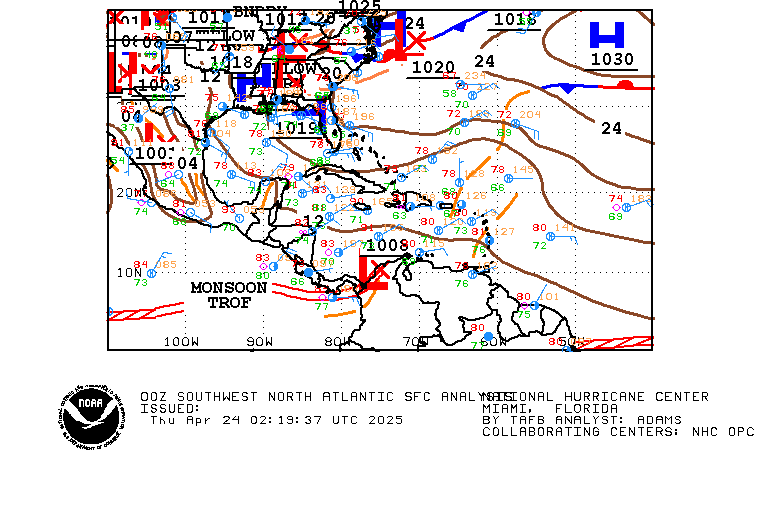
steering flow ... ridge still very much in place.. and forecast to stay for at least another 48 hours, by which time 97L or td will be approaching the central carrib.

and here is the latest analysis.. look where the high is forecast to move in 48 hours

and here is the latest analysis.. look where the high is forecast to move in 48 hours

0 likes
-
Aric Dunn
- Category 5

- Posts: 21238
- Age: 43
- Joined: Sun Sep 19, 2004 9:58 pm
- Location: Ready for the Chase.
- Contact:
Re:
KWT wrote:That exactly what the NHC showed yesterday Aric, the wave reaches hispanola and splits with the northern part heading angled as if its heading NW.
Besides the shear is increasing right now in front of it and so it'll likely suffer sooner or later and weaken and the jet won't move out the wave quickly enough to prevent that, so even if it forms now I doubt it'll be much of a system by the time it reaches more favorable shear conditions.
What will be interesting to observe is whether the convection flares up a lot like the previous wave did. That could help to give the system the short term boost it needs.
there is convection now.. quite a bit of it and organizing .. also the shear forecast as i said before in the carrib is to become more favorable.. yes in about 24 hours the shear will increase over the system then is forecast after that to decrease again. also if it develops it would have to weaken really fast fby the time it hits the shear at the islands, open back up to a wave then move northerly through a ridge that is clearly not going to move for it..
like the first wave a piece of energy broke off but most is still south .. same will happen with this if it DOES not develop .. if it does .. then the left over circulation ( if the shear completely kills it) would continue west through the carrib under the influence of the strong easterly flow in the low levels ..
0 likes
-
Aric Dunn
- Category 5

- Posts: 21238
- Age: 43
- Joined: Sun Sep 19, 2004 9:58 pm
- Location: Ready for the Chase.
- Contact:
Re: ATL: INVEST (97L)
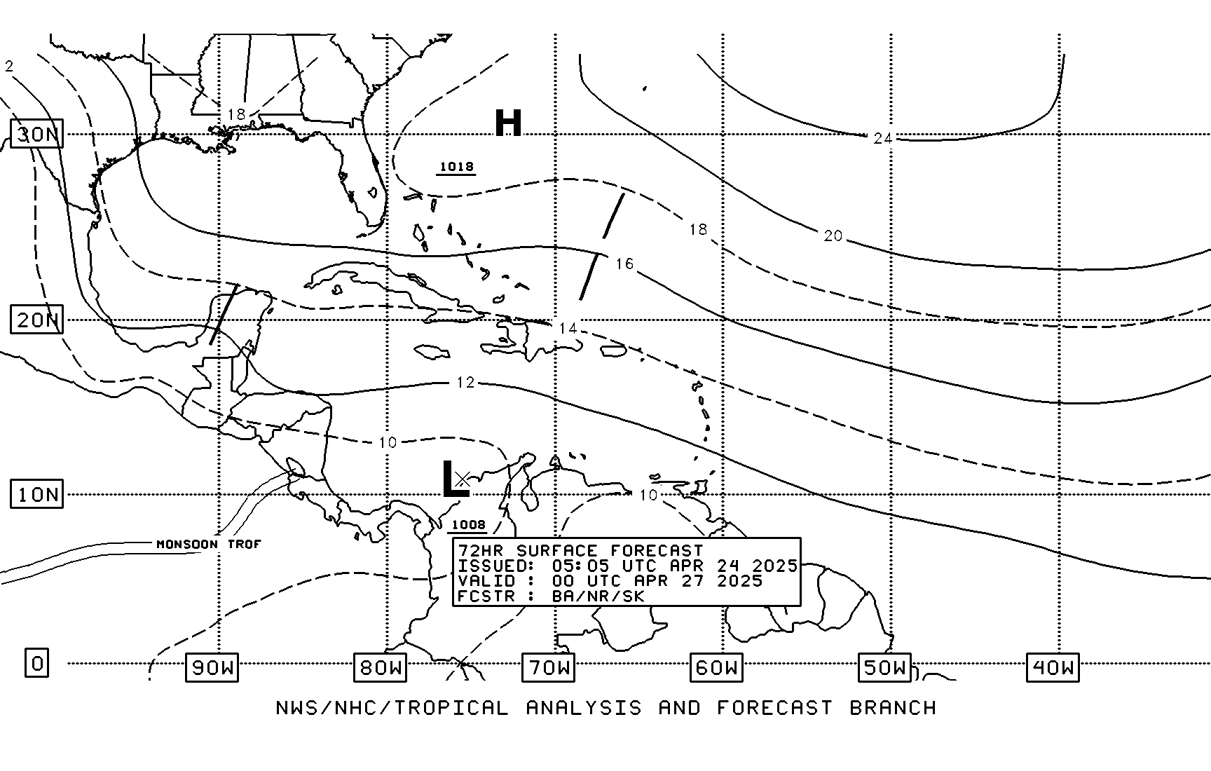
Also here is the 72 hour forecast by the NHC clearly showing the wave associated with 97L all south of Hispaniola. maybe you were looking at the models and saw something develop near Carolina's, that maybe the pieces of the first wave seen in the 72 forecast sitting off florida.


0 likes
- gatorcane
- S2K Supporter

- Posts: 23708
- Age: 48
- Joined: Sun Mar 13, 2005 3:54 pm
- Location: Boca Raton, FL
one thing is for sure, no model has picked up on 97L as far as projecting the way it would look now and its heading. GFS and ECMWF put this thing NE of the Leewards several days ago and still continue to do that for some reason. So not sure I would put too much emphasis on the models at this point. Still shows how tricky forecasting the development of these systems are for even these models.
Last edited by gatorcane on Sun Jul 19, 2009 1:12 pm, edited 1 time in total.
0 likes
- Blown Away
- S2K Supporter

- Posts: 10253
- Joined: Wed May 26, 2004 6:17 am
Re: ATL: INVEST (97L)
IMO, 97L has a WNW component, I know the clouds are expanding, but its gaining latitude. I think 97L is heading towards the NE Caribbean where the shear is decreasing and is heading towards Hispanola, imagine that. 
0 likes
- Gustywind
- Category 5

- Posts: 12334
- Joined: Mon Sep 03, 2007 7:29 am
- Location: Baie-Mahault, GUADELOUPE
000
AXNT20 KNHC 191721
TWDAT
TROPICAL WEATHER DISCUSSION
NWS TPC/NATIONAL HURRICANE CENTER MIAMI FL
205 PM EDT SUN JUL 19 2009
TROPICAL WEATHER DISCUSSION FOR NORTH AMERICA...CENTRAL
AMERICA...GULF OF MEXICO...CARIBBEAN SEA...NORTHERN SECTIONS
OF SOUTH AMERICA...AND ATLANTIC OCEAN TO THE AFRICAN COAST
FROM THE EQUATOR TO 32N. THE FOLLOWING INFORMATION IS BASED
ON SATELLITE IMAGERY...METEOROLOGICAL ANALYSIS...WEATHER
OBSERVATIONS...AND RADAR.
BASED ON 1200 UTC SURFACE ANALYSIS AND SATELLITE IMAGERY
THROUGH 1715 UTC.
...TROPICAL WAVES...
A TROPICAL WAVE IS ALONG 49W/50W SOUTH OF 17N MOVING WEST 15-20
KT. THIS WAVE COINCIDES WITH A LOW TO MIDDLE LEVEL CYCLONIC
CIRCULATION NEAR THE WAVE AXIS AT 13N51W. SCATTERED MODERATE TO
ISOLATED STRONG CONVECTION IS FROM 11N-14N BETWEEN 50W-53W.
$$
FORMOSA
0 likes
- gatorcane
- S2K Supporter

- Posts: 23708
- Age: 48
- Joined: Sun Mar 13, 2005 3:54 pm
- Location: Boca Raton, FL
Re:
KWT wrote:Yep thats what I'm looking at Aric, you can see the wave splits in half and the NW part heads up. 97L will likely continue the way its going.
I suspect the models are probably starting 97L too far north, or placing the main energy from 97L too far north, on of the two.
Yes I agree, models are keying in on the northern half of the wave. I suspect once more data is given to the models as to where this "surface low" may be forming, things will change with the projected long-term track. I'm thinking it has a chance of entering the Caribbean, maybe the NE part of the Caribbean or south of HIspaniola.
In this loop you can see alot of spin here, I'm pretty shocked it has gotten this organized.
http://www.ssd.noaa.gov/goes/flt/t1/loop-vis.html

Last edited by gatorcane on Sun Jul 19, 2009 1:17 pm, edited 2 times in total.
0 likes
- Blown Away
- S2K Supporter

- Posts: 10253
- Joined: Wed May 26, 2004 6:17 am
Re: ATL: INVEST (97L)
All these predictions are for a shallow wave if 97L deepens into a TD or TS I think a more WNW track is likely.
0 likes
- senorpepr
- Military Met/Moderator

- Posts: 12542
- Age: 43
- Joined: Fri Aug 22, 2003 9:22 pm
- Location: Mackenbach, Germany
- Contact:
Re:
senorpepr wrote:AL, 97, 2009071918, , BEST, 0, 122N, 525W, 25, 1012, DB, 34, NEQ, 0, 0, 0, 0, 1014, 125, 40, 0, 0, L, 0, , 0, 0, INVEST, M,
+5 kt; -1 hPa
That puts it moving W (or just south of W, unless there's a center displacement) at 25 mph
0 likes
- cycloneye
- Admin

- Posts: 149278
- Age: 69
- Joined: Thu Oct 10, 2002 10:54 am
- Location: San Juan, Puerto Rico
Re: ATL: INVEST (97L) Models
18 UTC Model Suite
WHXX01 KWBC 191813
CHGHUR
TROPICAL CYCLONE GUIDANCE MESSAGE
NWS TPC/NATIONAL HURRICANE CENTER MIAMI FL
1813 UTC SUN JUL 19 2009
DISCLAIMER...NUMERICAL MODELS ARE SUBJECT TO LARGE ERRORS.
PLEASE REFER TO NHC OFFICIAL FORECASTS FOR TROPICAL CYCLONE
AND SUBTROPICAL CYCLONE INFORMATION.
ATLANTIC OBJECTIVE AIDS FOR
DISTURBANCE INVEST (AL972009) 20090719 1800 UTC
...00 HRS... ...12 HRS... ...24 HRS. .. ...36 HRS...
090719 1800 090720 0600 090720 1800 090721 0600
LAT LON LAT LON LAT LON LAT LON
BAMS 12.2N 52.5W 13.0N 56.5W 14.6N 60.5W 16.0N 64.5W
BAMD 12.2N 52.5W 12.5N 54.8W 12.9N 57.2W 13.4N 59.7W
BAMM 12.2N 52.5W 12.7N 55.4W 13.5N 58.4W 14.4N 61.4W
LBAR 12.2N 52.5W 12.4N 56.0W 13.0N 59.8W 13.8N 63.7W
SHIP 25KTS 30KTS 35KTS 38KTS
DSHP 25KTS 30KTS 35KTS 38KTS
...48 HRS... ...72 HRS... ...96 HRS. .. ..120 HRS...
090721 1800 090722 1800 090723 1800 090724 1800
LAT LON LAT LON LAT LON LAT LON
BAMS 17.8N 68.6W 21.6N 75.7W 24.9N 79.4W 27.5N 79.5W
BAMD 13.9N 62.7W 15.1N 70.0W 16.3N 77.6W 16.6N 84.7W
BAMM 15.4N 64.8W 17.9N 72.3W 20.5N 78.7W 22.1N 83.2W
LBAR 14.9N 67.6W 17.3N 74.6W .0N .0W .0N .0W
SHIP 42KTS 50KTS 56KTS 61KTS
DSHP 42KTS 50KTS 53KTS 58KTS
...INITIAL CONDITIONS...
LATCUR = 12.2N LONCUR = 52.5W DIRCUR = 270DEG SPDCUR = 21KT
LATM12 = 12.4N LONM12 = 48.2W DIRM12 = 270DEG SPDM12 = 20KT
LATM24 = 12.3N LONM24 = 44.2W
WNDCUR = 25KT RMAXWD = 40NM WNDM12 = 20KT
CENPRS = 1012MB OUTPRS = 1014MB OUTRAD = 125NM SDEPTH = M
RD34NE = 0NM RD34SE = 0NM RD34SW = 0NM RD34NW = 0NM

0 likes
-
Aric Dunn
- Category 5

- Posts: 21238
- Age: 43
- Joined: Sun Sep 19, 2004 9:58 pm
- Location: Ready for the Chase.
- Contact:
Re: ATL: INVEST (97L)
below is an image of the first best track from this morning ( in black and the arrow pointing to where it was headed)
the white was my best track position and motion
the red circle is the new best track position ...
straight west movement right now and that is a new microwave image.. the center has convection all around it..

original image..

the white was my best track position and motion
the red circle is the new best track position ...
straight west movement right now and that is a new microwave image.. the center has convection all around it..

original image..

Last edited by Aric Dunn on Sun Jul 19, 2009 1:24 pm, edited 1 time in total.
0 likes
- cycloneye
- Admin

- Posts: 149278
- Age: 69
- Joined: Thu Oct 10, 2002 10:54 am
- Location: San Juan, Puerto Rico
Re: ATL: INVEST (97L)
It it stays in that west track south of 15N it may avoid the worst of the shear.
0 likes
Re: ATL: INVEST (97L)
Seems to be gaining a little distance from the small nearly naked swirl(circulation) @ 49w 9n to the SE of 97, might also aid in the LLC formation.
0 likes
- Blown Away
- S2K Supporter

- Posts: 10253
- Joined: Wed May 26, 2004 6:17 am
Re: ATL: INVEST (97L)
cycloneye wrote:It it stays in that west track south of 15N it may avoid the worst of the shear.
Looking at the shear maps, in 48 hours the shear will be <15 kts all over the NE Caribbean. In 48 hours the shear in the Bahama area will be near 20 kts but it will be on a decreasing trend. So I'm not so sure it has to stay below 15N to survive. I think it's going to move very close to Hispanola. JMHO.
0 likes
Who is online
Users browsing this forum: No registered users and 28 guests