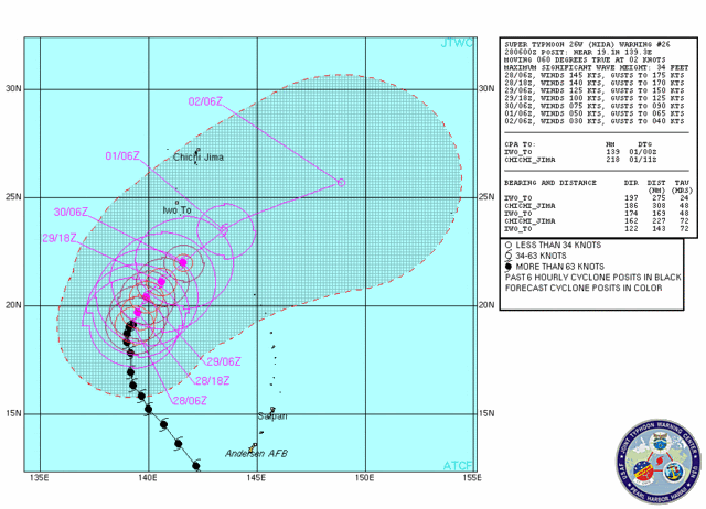
WPAC : TROPICAL DEPRESSION NIDA (26W)

Moderator: S2k Moderators

Message
Author
User avatar
JTE50
Category 1
Category 1
Posts: 336
Age: 66
Joined: Mon Jul 21, 2008 10:48 am
Location: Pensacola
Contact:

Re: WPAC : TYPHOON NIDA (26W)

#341 Postby JTE50 » Fri Nov 27, 2009 11:49 pm

Infdidoll wrote:
JTE50 wrote:It's been raining all morning here on Guam. It's interesting in that we had a partly sunny day on Thansgiving but the past two days have been rainy now that we are in an inflow band. Everybody here is asking me if Nida is coming back to Guam - they seel all the rain and are getting worried. The typical rain showers that pass through only last 5-10 min. Anything beyond that and the locals know something is not right.


I was wondering what the folks in Guam were experiencing...Radar shows what look like really heavy storms and rain associated with the back edge of the storm. I hope it doesn't turn and head back that way - not at the intensity it's at, right now. That would truly be devastating. Are the winds really bad there as well?


The winds are too bad at all - at least where I'm at in Tumon Bay - the middle western side of Guam. The Weather Service Office has all kinds of warnings and advisories out - high surg, flood, special marine conditions. The surfers are out in force - they love it.

I think it would be really strange to see a track back to Guam - but then I saw a Hurricane named Lenny track from west to east in the Caribbean so who knows! Even the NHC said we have no skill in forecasting a hurricane moving like Lenny!
0 likes   

oaba09
S2K Supporter
S2K Supporter
Posts: 1496
Age: 38
Joined: Thu Oct 01, 2009 10:02 am
Location: Valenzuela, Philippines
Contact:

#342 Postby oaba09 » Sat Nov 28, 2009 12:06 am

Image

<Analyses at 28/03 UTC>
Scale -
Intensity Very Strong
Center position N19°05'(19.1°)
E139°00'(139.0°)
Direction and speed of movement NNW Slowly
Central pressure 925hPa
Maximum wind speed near the center 50m/s(95kt)
Maximum wind gust speed 70m/s(135kt)
Area of 50kt winds or more Wide 130km(70NM)
Area of 30kt winds or more N480km(260NM)
S300km(160NM)
<Forecast for 29/03 UTC>
Intensity Very Strong
Center position of probability circle N19°25'(19.4°)
E138°50'(138.8°)
Direction and speed of movement STR
Central pressure 940hPa
Maximum wind speed near the center 45m/s(85kt)
Maximum wind gust speed 60m/s(120kt)
Radius of probability circle 130km(70NM)
Storm warning area Wide 240km(130NM)
<Forecast for 30/00 UTC>
Intensity Strong
Center position of probability circle N19°35'(19.6°)
E138°05'(138.1°)
Direction and speed of movement STR
Central pressure 950hPa
Maximum wind speed near the center 40m/s(80kt)
Maximum wind gust speed 60m/s(115kt)
Radius of probability circle 200km(110NM)
Storm warning area Wide 310km(170NM)
<Forecast for 01/00 UTC>
Intensity Strong
Center position of probability circle N19°55'(19.9°)
E136°55'(136.9°)
Direction and speed of movement WNW Slowly
Central pressure 965hPa
Maximum wind speed near the center 35m/s(70kt)
Maximum wind gust speed 50m/s(100kt)
Radius of probability circle 300km(160NM)
Storm warning area Wide 390km(210NM)
<Forecast for 02/00 UTC>
Center position of probability circle N20°05'(20.1°)
E136°05'(136.1°)
Direction and speed of movement STR
Radius of probability circle 650km(350NM)
<Forecast for 03/00 UTC>
Center position of probability circle N20°10'(20.2°)
E135°30'(135.5°)
Direction and speed of movement STR
Radius of probability circle 950km(500NM)
0 likes   

User avatar
HURAKAN
Professional-Met
Professional-Met
Posts: 46086
Age: 38
Joined: Thu May 20, 2004 4:34 pm
Location: Key West, FL
Contact:

#343 Postby HURAKAN » Sat Nov 28, 2009 12:23 am

Image

Still looking very impressive
0 likes   

oaba09
S2K Supporter
S2K Supporter
Posts: 1496
Age: 38
Joined: Thu Oct 01, 2009 10:02 am
Location: Valenzuela, Philippines
Contact:

#344 Postby oaba09 » Sat Nov 28, 2009 1:02 am

Looking at the latest sat loops, nida seems to be stationary at this moment......I'm really anxious to see where she'll go......
0 likes   

User avatar
ManilaTC
WesternPacificWeather.com
Posts: 593
Age: 46
Joined: Mon Oct 26, 2009 5:13 am
Location: Mandaluyong City, Philippines
Contact:

#345 Postby ManilaTC » Sat Nov 28, 2009 1:10 am

This is very crazy. two opposite forecasts 180 deg apart
0 likes   
The above post is NOT official and should not be used as such. It is my opinion and may or may not be backed by sound meteorological data. It is not endorsed by any professional institution or storm2k.org. Please refer to your official national weather agency.

WEB http://goo.gl/JDiKXB | FB https://goo.gl/N5sIle | @ManilaTC

User avatar
JTE50
Category 1
Category 1
Posts: 336
Age: 66
Joined: Mon Jul 21, 2008 10:48 am
Location: Pensacola
Contact:

Re: WPAC : TYPHOON NIDA (26W)

#346 Postby JTE50 » Sat Nov 28, 2009 1:51 am

I'll go with the JTWC forecast . . . anybody go with the JMA forecast??? James??? :)
0 likes   

oaba09
S2K Supporter
S2K Supporter
Posts: 1496
Age: 38
Joined: Thu Oct 01, 2009 10:02 am
Location: Valenzuela, Philippines
Contact:

#347 Postby oaba09 » Sat Nov 28, 2009 1:55 am

Latest from JMA

<Analyses at 28/06 UTC>
Scale -
Intensity Very Strong
Center position N19°05'(19.1°)
E139°10'(139.2°)
Direction and speed of movement STR
Central pressure 925hPa
Maximum wind speed near the center 50m/s(95kt)
Maximum wind gust speed 70m/s(135kt)
Area of 50kt winds or more Wide 130km(70NM)
Area of 30kt winds or more N480km(260NM)
S300km(160NM)
<Forecast for 29/06 UTC>
Intensity Very Strong
Center position of probability circle N19°30'(19.5°)
E138°40'(138.7°)
Direction and speed of movement STR
Central pressure 940hPa
Maximum wind speed near the center 45m/s(85kt)
Maximum wind gust speed 60m/s(120kt)
Radius of probability circle 160km(85NM)
Storm warning area Wide 260km(140NM)
<Forecast for 30/06 UTC>
Intensity Strong
Center position of probability circle N19°50'(19.8°)
E137°55'(137.9°)
Direction and speed of movement STR
Central pressure 950hPa
Maximum wind speed near the center 40m/s(80kt)
Maximum wind gust speed 60m/s(115kt)
Radius of probability circle 300km(160NM)
Storm warning area Wide 390km(210NM)
<Forecast for 01/06 UTC>
Intensity Strong
Center position of probability circle N19°55'(19.9°)
E136°35'(136.6°)
Direction and speed of movement W Slowly
Central pressure 965hPa
Maximum wind speed near the center 35m/s(70kt)
Maximum wind gust speed 50m/s(100kt)
Radius of probability circle 410km(220NM)
Storm warning area Wide 480km(260NM)

Image
0 likes   

User avatar
ManilaTC
WesternPacificWeather.com
Posts: 593
Age: 46
Joined: Mon Oct 26, 2009 5:13 am
Location: Mandaluyong City, Philippines
Contact:

#348 Postby ManilaTC » Sat Nov 28, 2009 1:59 am

That looks like its making a counter clockwise loop...
0 likes   
The above post is NOT official and should not be used as such. It is my opinion and may or may not be backed by sound meteorological data. It is not endorsed by any professional institution or storm2k.org. Please refer to your official national weather agency.

WEB http://goo.gl/JDiKXB | FB https://goo.gl/N5sIle | @ManilaTC

User avatar
P.K.
Professional-Met
Professional-Met
Posts: 5149
Joined: Thu Sep 23, 2004 5:57 pm
Location: Watford, England
Contact:

Re: WPAC : TYPHOON NIDA (26W)

#349 Postby P.K. » Sat Nov 28, 2009 2:44 am

Seems to be bit of a split in the agencies at the moment. Half show a recurve and half show a NW movement.

Image
0 likes   

ozonepete
Professional-Met
Professional-Met
Posts: 4743
Joined: Mon Sep 07, 2009 3:23 pm
Location: From Ozone Park, NYC / Now in Brooklyn, NY

Re: WPAC : TYPHOON NIDA (26W)

#350 Postby ozonepete » Sat Nov 28, 2009 3:52 am

Although Nida has clearly stalled out for the moment, you still have to look at the overall synoptic setup to figure out where it's going. There's another decently strong 500mb trough moving in over China behind the one that has blocked Nida from moving westward. The JMA forecast is very unrealistic - probably not accounting enough for the already pretty high lattitude of Nida and the next 500mb trough moving quickly into that area of the subtropics - i.e. their forecast algorithms can't handle cool season dynamics. This still looks like a classic recurving tropical cyclone. I can't see any other outcome for Nida right now other than a northeast recurve, even if it sits in the same place for the next 6-12 hours. No forecasts have the STR to its east building west or northwestward near or above 20 degrees north.
0 likes   

ozonepete
Professional-Met
Professional-Met
Posts: 4743
Joined: Mon Sep 07, 2009 3:23 pm
Location: From Ozone Park, NYC / Now in Brooklyn, NY

Re: WPAC : TYPHOON NIDA (26W)

#351 Postby ozonepete » Sat Nov 28, 2009 4:28 am

I can't see a reason to argue with the JTWC track.

Image
0 likes   

Typhoon Hunter
WesternPacificWeather.com
Posts: 1221
Joined: Wed Oct 11, 2006 11:37 am
Location: Tokyo
Contact:

Re: WPAC : TYPHOON NIDA (26W)

#352 Postby Typhoon Hunter » Sat Nov 28, 2009 5:13 am

JTE50 wrote:I'll go with the JTWC forecast . . . anybody go with the JMA forecast??? James??? :)


I got $5 on JMA track :P :D

Latest ECMWF run is quite bizarre - shows Nida interacting with another circulation following on behind it. It'll be fascinating to see what pans out.
0 likes   
James - Documenting tropical cyclones...

http://www.youtube.com/TyphoonHunter

oaba09
S2K Supporter
S2K Supporter
Posts: 1496
Age: 38
Joined: Thu Oct 01, 2009 10:02 am
Location: Valenzuela, Philippines
Contact:

#353 Postby oaba09 » Sat Nov 28, 2009 5:22 am

LATEST JMA

<Analyses at 28/09 UTC>
Scale -
Intensity Very Strong
Center position N19°00'(19.0°)
E139°20'(139.3°)
Direction and speed of movement STR
Central pressure 925hPa
Maximum wind speed near the center 50m/s(95kt)
Maximum wind gust speed 70m/s(135kt)
Area of 50kt winds or more Wide 130km(70NM)
Area of 30kt winds or more N480km(260NM)
S300km(160NM)
<Forecast for 29/09 UTC>
Intensity Very Strong
Center position of probability circle N19°20'(19.3°)
E138°40'(138.7°)
Direction and speed of movement STR
Central pressure 940hPa
Maximum wind speed near the center 45m/s(85kt)
Maximum wind gust speed 60m/s(120kt)
Radius of probability circle 160km(85NM)
Storm warning area Wide 260km(140NM)
<Forecast for 30/06 UTC>
Intensity Strong
Center position of probability circle N19°50'(19.8°)
E137°55'(137.9°)
Direction and speed of movement STR
Central pressure 950hPa
Maximum wind speed near the center 40m/s(80kt)
Maximum wind gust speed 60m/s(115kt)
Radius of probability circle 300km(160NM)
Storm warning area Wide 390km(210NM)
<Forecast for 01/06 UTC>
Intensity Strong
Center position of probability circle N19°55'(19.9°)
E136°35'(136.6°)
Direction and speed of movement W Slowly
Central pressure 965hPa
Maximum wind speed near the center 35m/s(70kt)

Image
0 likes   

oaba09
S2K Supporter
S2K Supporter
Posts: 1496
Age: 38
Joined: Thu Oct 01, 2009 10:02 am
Location: Valenzuela, Philippines
Contact:

#354 Postby oaba09 » Sat Nov 28, 2009 5:25 am

Based on this image, I don't see how the system can go west.....The weird thing is, a lot of the models are predicting a western movement...

Image
0 likes   

oaba09
S2K Supporter
S2K Supporter
Posts: 1496
Age: 38
Joined: Thu Oct 01, 2009 10:02 am
Location: Valenzuela, Philippines
Contact:

Re: WPAC : TYPHOON NIDA (26W)

#355 Postby oaba09 » Sat Nov 28, 2009 6:36 am

Typhoon Hunter wrote:
JTE50 wrote:I'll go with the JTWC forecast . . . anybody go with the JMA forecast??? James??? :)


I got $5 on JMA track :P :D

Latest ECMWF run is quite bizarre - shows Nida interacting with another circulation following on behind it. It'll be fascinating to see what pans out.


I got $10 on the JTWC track LOL :D
0 likes   

User avatar
cycloneye
Admin
Admin
Posts: 143863
Age: 68
Joined: Thu Oct 10, 2002 10:54 am
Location: San Juan, Puerto Rico

Re: WPAC : TYPHOON NIDA (26W)

#356 Postby cycloneye » Sat Nov 28, 2009 6:46 am

For the record,here is the text of the 06:00Z JTWC warning at 145 kts.

WTPN31 PGTW 280900
MSGID/GENADMIN/NAVMARFCSTCEN PEARL HARBOR HI/JTWC//
SUBJ/TROPICAL CYCLONE WARNING//
RMKS/
1. SUPER TYPHOON 26W (NIDA) WARNING NR 026
01 ACTIVE TROPICAL CYCLONE IN NORTHWESTPAC
MAX SUSTAINED WINDS BASED ON ONE-MINUTE AVERAGE
WIND RADII VALID OVER OPEN WATER ONLY
---
WARNING POSITION:
280600Z --- NEAR 19.1N 139.3E
MOVEMENT PAST SIX HOURS - 060 DEGREES AT 02 KTS
POSITION ACCURATE TO WITHIN 020 NM
POSITION BASED ON EYE FIXED BY SATELLITE
PRESENT WIND DISTRIBUTION:
MAX SUSTAINED WINDS - 145 KT, GUSTS 175 KT
WIND RADII VALID OVER OPEN WATER ONLY
RADIUS OF 064 KT WINDS - 055 NM NORTHEAST QUADRANT
055 NM SOUTHEAST QUADRANT
050 NM SOUTHWEST QUADRANT
050 NM NORTHWEST QUADRANT
RADIUS OF 050 KT WINDS - 080 NM NORTHEAST QUADRANT
080 NM SOUTHEAST QUADRANT
075 NM SOUTHWEST QUADRANT
075 NM NORTHWEST QUADRANT
RADIUS OF 034 KT WINDS - 130 NM NORTHEAST QUADRANT
120 NM SOUTHEAST QUADRANT
115 NM SOUTHWEST QUADRANT
135 NM NORTHWEST QUADRANT
REPEAT POSIT: 19.1N 139.3E
---
FORECASTS:
12 HRS, VALID AT:
281800Z --- 19.7N 139.5E
MAX SUSTAINED WINDS - 140 KT, GUSTS 170 KT
WIND RADII VALID OVER OPEN WATER ONLY
RADIUS OF 064 KT WINDS - 050 NM NORTHEAST QUADRANT
050 NM SOUTHEAST QUADRANT
045 NM SOUTHWEST QUADRANT
045 NM NORTHWEST QUADRANT
RADIUS OF 050 KT WINDS - 080 NM NORTHEAST QUADRANT
080 NM SOUTHEAST QUADRANT
075 NM SOUTHWEST QUADRANT
075 NM NORTHWEST QUADRANT
RADIUS OF 034 KT WINDS - 135 NM NORTHEAST QUADRANT
125 NM SOUTHEAST QUADRANT
120 NM SOUTHWEST QUADRANT
135 NM NORTHWEST QUADRANT
VECTOR TO 24 HR POSIT: 030 DEG/ 04 KTS
---
24 HRS, VALID AT:
290600Z --- 20.4N 139.9E
MAX SUSTAINED WINDS - 125 KT, GUSTS 150 KT
WIND RADII VALID OVER OPEN WATER ONLY
RADIUS OF 064 KT WINDS - 045 NM NORTHEAST QUADRANT
045 NM SOUTHEAST QUADRANT
045 NM SOUTHWEST QUADRANT
045 NM NORTHWEST QUADRANT
RADIUS OF 050 KT WINDS - 075 NM NORTHEAST QUADRANT
075 NM SOUTHEAST QUADRANT
075 NM SOUTHWEST QUADRANT
070 NM NORTHWEST QUADRANT
RADIUS OF 034 KT WINDS - 135 NM NORTHEAST QUADRANT
135 NM SOUTHEAST QUADRANT
130 NM SOUTHWEST QUADRANT
135 NM NORTHWEST QUADRANT
VECTOR TO 36 HR POSIT: 045 DEG/ 05 KTS
---
36 HRS, VALID AT:
291800Z --- 21.1N 140.6E
MAX SUSTAINED WINDS - 100 KT, GUSTS 125 KT
WIND RADII VALID OVER OPEN WATER ONLY
RADIUS OF 064 KT WINDS - 040 NM NORTHEAST QUADRANT
040 NM SOUTHEAST QUADRANT
040 NM SOUTHWEST QUADRANT
040 NM NORTHWEST QUADRANT
RADIUS OF 050 KT WINDS - 070 NM NORTHEAST QUADRANT
070 NM SOUTHEAST QUADRANT
065 NM SOUTHWEST QUADRANT
065 NM NORTHWEST QUADRANT
RADIUS OF 034 KT WINDS - 140 NM NORTHEAST QUADRANT
140 NM SOUTHEAST QUADRANT
130 NM SOUTHWEST QUADRANT
135 NM NORTHWEST QUADRANT
VECTOR TO 48 HR POSIT: 045 DEG/ 06 KTS
---
EXTENDED OUTLOOK:
48 HRS, VALID AT:
300600Z --- 22.0N 141.6E
MAX SUSTAINED WINDS - 075 KT, GUSTS 090 KT
WIND RADII VALID OVER OPEN WATER ONLY
RADIUS OF 064 KT WINDS - 025 NM NORTHEAST QUADRANT
025 NM SOUTHEAST QUADRANT
025 NM SOUTHWEST QUADRANT
025 NM NORTHWEST QUADRANT
RADIUS OF 050 KT WINDS - 050 NM NORTHEAST QUADRANT
055 NM SOUTHEAST QUADRANT
050 NM SOUTHWEST QUADRANT
050 NM NORTHWEST QUADRANT
RADIUS OF 034 KT WINDS - 130 NM NORTHEAST QUADRANT
130 NM SOUTHEAST QUADRANT
120 NM SOUTHWEST QUADRANT
125 NM NORTHWEST QUADRANT
VECTOR TO 72 HR POSIT: 050 DEG/ 06 KTS
---
72 HRS, VALID AT:
010600Z --- 23.5N 143.5E
MAX SUSTAINED WINDS - 050 KT, GUSTS 065 KT
WIND RADII VALID OVER OPEN WATER ONLY
BECOMING EXTRATROPICAL
RADIUS OF 034 KT WINDS - 075 NM NORTHEAST QUADRANT
080 NM SOUTHEAST QUADRANT
070 NM SOUTHWEST QUADRANT
070 NM NORTHWEST QUADRANT
VECTOR TO 96 HR POSIT: 065 DEG/ 13 KTS
---
LONG RANGE OUTLOOK:
NOTE...ERRORS FOR TRACK HAVE AVERAGED NEAR 250 NM
ON DAY 4 AND 350 NM ON DAY 5... AND FOR INTENSITY
NEAR 20 KT EACH DAY.
---
96 HRS, VALID AT:
020600Z --- 25.7N 148.9E
MAX SUSTAINED WINDS - 030 KT, GUSTS 040 KT
WIND RADII VALID OVER OPEN WATER ONLY
EXTRATROPICAL
---
REMARKS:
280900Z POSITION NEAR 19.3N 139.3E.
SUPER TYPHOON (STY) 26W (NIDA), LOCATED APPROXIMATELY 355 NM SOUTH-
SOUTHWEST OF IWO TO, HAS TRACKED EAST-NORTHEASTWARD AT 02 KNOTS OVER
THE PAST SIX HOURS. ANIMATED MULTISPECTRAL SATELLITE IMAGERY (MSI)
SHOWS THAT STY 26W HAS BEEN ALMOST STATIONARY FOR THE PAST 9 HOURS,
WITH A NOTICEABLE WOBBLE OBSERVED IN THE MSI. MODEL GUIDANCE REMAINS
IN POOR AGREEMENT WITH JGSM, ECMWF, UKMO AND GFS SHOWING A WESTWARD
TRACK. WBAR, TC-LAPS, GFDN AND NGPS MAINTAIN A RE-CURVE FORECAST.
NGPS HAS PERSISTED WITH EXCESSIVE TRACK SPEEDS AND ERRONEOUS INTEN-
SITY VALUES OUT TO TAU 120. THE FORECAST REASONING HAS NOT SHIFTED
FROM THE PREVIOUS FORECAST, KEEPING THE CURRENT TRACK SPEEDS SLOW
THROUGH TAU 48, INCREASING SPEED BEYOND TAU 48 AS STY 26W MOVES
SLOWLY NORTHWARD AROUND THE WESTERN EXTENT OF THE MID-LEVEL SUB-
TROPICAL RIDGE (STR). THE STR IS EXPECTED TO BUILD SLOWLY WESTWARD
TO PROVIDE THE STEERING SUPPORT IN THE LATER TAUS. A 280426Z AMSR-E
IMAGE SHOWS THAT THE INNER EYEWALL CONTINUES TO WEAKEN WHILE THE
SECONDARY EYEWALL IS BEGINNING TO CONSTRICT INWARD. DVORAK ESTIMATES
FROM PGTW AND RJTD REFLECT A SLIGHT DECREASE IN INTENSITY OVER THE
PAST 6 HOURS, BRING THE CURRENT INTENSITY TO 145 KNOTS. THE FORECAST
REMAINS CONSISTENT WITH A SLOW WEAKENING TREND AS STY 26W MOVES INTO
A LESS FAVORABLE ENVIRONMENT, WITH INCREASING VERTICAL WIND SHEAR AND
DECREASING OCEAN HEAT CONTENT/SEA SURFACE TEMPERATURES. MAXIMUM
SIGNIFICANT WAVE HEIGHT AT 280600Z IS 34 FEET. NEXT WARNINGS AT
281500Z, 282100Z, 290300Z AND 290900Z.//
NNNN

0 likes   
Visit the Caribbean-Central America Weather Thread where you can find at first post web cams,radars
and observations from Caribbean basin members Click Here

ricmood

Re: WPAC : TYPHOON NIDA (26W)

#357 Postby ricmood » Sat Nov 28, 2009 6:55 am

How about this?

Image
0 likes   

oaba09
S2K Supporter
S2K Supporter
Posts: 1496
Age: 38
Joined: Thu Oct 01, 2009 10:02 am
Location: Valenzuela, Philippines
Contact:

#358 Postby oaba09 » Sat Nov 28, 2009 6:57 am

Image

seems to be weakening...
0 likes   

ozonepete
Professional-Met
Professional-Met
Posts: 4743
Joined: Mon Sep 07, 2009 3:23 pm
Location: From Ozone Park, NYC / Now in Brooklyn, NY

Re: WPAC : TYPHOON NIDA (26W)

#359 Postby ozonepete » Sat Nov 28, 2009 6:57 am

oaba09 wrote:
Typhoon Hunter wrote:
JTE50 wrote:I'll go with the JTWC forecast . . . anybody go with the JMA forecast??? James??? :)


I got $5 on JMA track :P :D

Latest ECMWF run is quite bizarre - shows Nida interacting with another circulation following on behind it. It'll be fascinating to see what pans out.


I got $10 on the JTWC track LOL :D


LOL! I'll see you that 10 and raise you 10.
0 likes   

User avatar
Infdidoll
Category 2
Category 2
Posts: 667
Age: 47
Joined: Thu Oct 01, 2009 8:39 pm
Location: Temecula, CA

Re: WPAC : TYPHOON NIDA (26W)

#360 Postby Infdidoll » Sat Nov 28, 2009 7:03 am

And I'll raise you all $10 that it's a typhoon...and goes where it wants to and doesn't give a ___ about the tracks. :wink: lol
0 likes   


Return to “2009”

Who is online

Users browsing this forum: No registered users and 18 guests