533
WHXX01 KWBC 221836
CHGHUR
TROPICAL CYCLONE GUIDANCE MESSAGE
NWS TPC/NATIONAL HURRICANE CENTER MIAMI FL
1836 UTC FRI MAY 22 2009
DISCLAIMER...NUMERICAL MODELS ARE SUBJECT TO LARGE ERRORS.
PLEASE REFER TO NHC OFFICIAL FORECASTS FOR TROPICAL CYCLONE
AND SUBTROPICAL CYCLONE INFORMATION.
ATLANTIC OBJECTIVE AIDS FOR
DISTURBANCE INVEST (AL902009) 20090522 1800 UTC
...00 HRS... ...12 HRS... ...24 HRS. .. ...36 HRS...
090522 1800 090523 0600 090523 1800 090524 0600
LAT LON LAT LON LAT LON LAT LON
BAMS 27.1N 87.3W 28.6N 88.0W 30.1N 88.5W 31.7N 89.0W
BAMD 27.1N 87.3W 28.5N 87.5W 30.4N 88.3W 32.3N 89.3W
BAMM 27.1N 87.3W 28.4N 87.4W 30.2N 87.7W 32.2N 88.0W
LBAR 27.1N 87.3W 28.2N 87.0W 29.6N 87.2W 31.2N 87.2W
SHIP 25KTS 29KTS 35KTS 41KTS
DSHP 25KTS 29KTS 35KTS 29KTS
...48 HRS... ...72 HRS... ...96 HRS. .. ..120 HRS...
090524 1800 090525 1800 090526 1800 090527 1800
LAT LON LAT LON LAT LON LAT LON
BAMS 33.3N 89.3W 36.0N 90.0W 38.9N 89.1W 41.2N 86.2W
BAMD 34.1N 90.5W 37.4N 92.3W 41.6N 92.2W 44.5N 87.0W
BAMM 34.1N 88.6W 37.4N 89.5W 41.0N 88.5W 43.5N 83.6W
LBAR 32.7N 87.2W 35.7N 85.5W 37.5N 81.4W 38.3N 74.2W
SHIP 45KTS 50KTS 51KTS 49KTS
DSHP 27KTS 27KTS 29KTS 30KTS
...INITIAL CONDITIONS...
LATCUR = 27.1N LONCUR = 87.3W DIRCUR = 0DEG SPDCUR = 4KT
LATM12 = 26.3N LONM12 = 87.1W DIRM12 = 323DEG SPDM12 = 4KT
LATM24 = 25.8N LONM24 = 86.5W
WNDCUR = 25KT RMAXWD = 150NM WNDM12 = 25KT
CENPRS = 1006MB OUTPRS = 1011MB OUTRAD = 250NM SDEPTH = M
RD34NE = 0NM RD34SE = 0NM RD34SW = 0NM RD34NW = 0NM
GOM: INVEST 90L
Moderator: S2k Moderators
-
cycloneye

- Admin

- Posts: 149508
- Age: 69
- Joined: Thu Oct 10, 2002 10:54 am
- Location: San Juan, Puerto Rico
Re: GOM: Invest 90L Models
0 likes
-
wxman57

- Moderator-Pro Met

- Posts: 23175
- Age: 68
- Joined: Sat Jun 21, 2003 8:06 pm
- Location: Houston, TX (southwest)
Re: GOM: INVEST 90L - STWO: Less than 30%
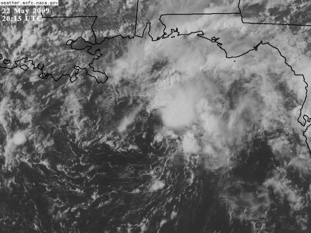
Center was initialized on one of those small vortices that's rotating around a larger broad center. That vortex is dying out now. Less than 24 hours left offshore, and water gets cooler toward the coast. If it was offshore another few days, then maybe it would have a chance. I doubt it'll look much different tomorrow morning as it's nearing the coast than it does now. Whether the NHC will name it after it moves inland (like Arthur last year), no one can predict.
0 likes
-
gatorcane

- S2K Supporter

- Posts: 23708
- Age: 48
- Joined: Sun Mar 13, 2005 3:54 pm
- Location: Boca Raton, FL
Re: GOM: INVEST 90L
vbhoutex wrote:Stormcenter wrote:I'm sorry but 90L still looks like crap. Yes I know looks can be deceiving but in this case I think they are not.
Unless the dry air entrainment stops it appears to be doomed to me. I do understand them doing an Invest, just in case, but conditions currently don't look too hopeful for 90L.
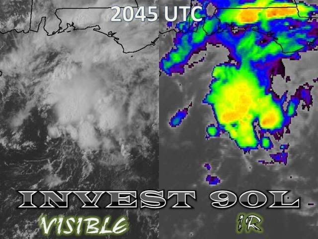
The dry air is not the main problem right now. It's mostly the marginal SSTs combined with some moderate shear over the system and an overall lack of organization of 90L to being with. Albeit we do note the shear tendency is negative, a bit too late though.
Compare this image to about 48 hours ago and notice how much less dry air there is. In this image, you see some dry air on the west side (the dark band) buts its just small infusion of dry air, not enough to do considerable damage to it. Just about any system any time of year will see some amount of dry air wrap into it as it moves north into the Gulf coast as relatively drier air is pulled down from the continental US.
It doesn't really matter anyway, I am with Wxman on thinking Anna will not develop.

0 likes

Re: GOM: INVEST 90L - STWO: Less than 30%
Shear will be lower by evening, below 10 kt, so there's a possibility that tstorm activity near the center will increase overnight. Since there is the possibility of some organization before the low is over land, it it logical to start an invest.
SSTs are below 27C and OHC in the shallow waters is practically nonexistent.
SSTs are below 27C and OHC in the shallow waters is practically nonexistent.
0 likes
-
Tampa Bay Hurricane

- Category 5

- Posts: 5597
- Age: 38
- Joined: Fri Jul 22, 2005 7:54 pm
- Location: St. Petersburg, FL

-
Tampa Bay Hurricane
- Category 5
- Posts: 5597
- Age: 38
- Joined: Fri Jul 22, 2005 7:54 pm
- Location: St. Petersburg, FL
Re: GOM: INVEST 90L - STWO: Less than 30%
Lost power briefly with the lightning and gusty winds in that
squall.
Although this low is pretty weak, there is more concentrated
convection and it may or may not get a name
for a few hours prior to landfall.

squall.
Although this low is pretty weak, there is more concentrated
convection and it may or may not get a name
for a few hours prior to landfall.
0 likes
-
tolakram
- Admin
- Posts: 20186
- Age: 62
- Joined: Sun Aug 27, 2006 8:23 pm
- Location: Florence, KY (name is Mark)
Re: GOM: INVEST 90L - STWO: Less than 30%
Looking at buoy data, at least what's available, the temperature near the center appears to be 73F while the temperature in squalls to the est of the center is 75F.
0 likes

-
Tampa Bay Hurricane
- Category 5
- Posts: 5597
- Age: 38
- Joined: Fri Jul 22, 2005 7:54 pm
- Location: St. Petersburg, FL
SE 23 G 32 MPH
Saint Petersburg...with the last "squall".
http://forecast.weather.gov/MapClick.ph ... &map.y=155
MacDill Air Force Base, Tampa:
SE 17 G 30 MPH
http://forecast.weather.gov/MapClick.ph ... &map.y=146
New Smyrna Beach, Near Daytona Beach:
SE 20 G 32 MPH
http://www.srh.noaa.gov/data/obhistory/KEVB.html
Clearwater Beach:
http://www.ndbc.noaa.gov/station_page.php?station=CWBF1
E 15 G 31 MPH
Tornado Reported...Quite a bit of spin:
Yes I know it is not about 40 mph, but the squalls
are almost "depression force".
With convection blowing up on the NE side of the system
it may briefly get a name.
Is poor structure the only reason it is not named yet?
Saint Petersburg...with the last "squall".
http://forecast.weather.gov/MapClick.ph ... &map.y=155
MacDill Air Force Base, Tampa:
SE 17 G 30 MPH
http://forecast.weather.gov/MapClick.ph ... &map.y=146
New Smyrna Beach, Near Daytona Beach:
SE 20 G 32 MPH
http://www.srh.noaa.gov/data/obhistory/KEVB.html
Clearwater Beach:
http://www.ndbc.noaa.gov/station_page.php?station=CWBF1
E 15 G 31 MPH
Tornado Reported...Quite a bit of spin:
05/22/2009 1245 PM
2 miles WSW of Clearwater, Pinellas County.
Tornado, reported by public.
Received picture of tornado taken by public. No damage
reported at this time. Time estimated by radar.
Yes I know it is not about 40 mph, but the squalls
are almost "depression force".
With convection blowing up on the NE side of the system
it may briefly get a name.
Is poor structure the only reason it is not named yet?
Last edited by Tampa Bay Hurricane on Fri May 22, 2009 3:34 pm, edited 1 time in total.
0 likes
-
Bailey1777
- S2K Supporter
- Posts: 962
- Joined: Mon Jul 31, 2006 6:23 pm
- Location: Houston, Texas


-
Tampa Bay Hurricane
- Category 5
- Posts: 5597
- Age: 38
- Joined: Fri Jul 22, 2005 7:54 pm
- Location: St. Petersburg, FL
Re:
Bailey1777 wrote:My understanding is that it is still for the most part cold-core
That is probably why...cold core systems produce squalls with gusty winds as
well...interesting...wow this thing has taken 5 days over the gulf and
STILL hasn't transitioned yet
This is a lot like Barry 2007...it became extratropical as it crossed
Florida...and the squall was cold-front like on June 2nd, 2007.
Very similar...winds similar as well.
0 likes
Re: GOM: INVEST 90L - STWO: Less than 30%
Actually appears to have a NNE drift at the moment.
0 likes
-
Tampa Bay Hurricane
- Category 5
- Posts: 5597
- Age: 38
- Joined: Fri Jul 22, 2005 7:54 pm
- Location: St. Petersburg, FL
Radar image of circulation
http://www.accuweather.com/radar-state. ... 0&site=FL_
200-250 miles West of Tampa Bay, moving North.
http://www.accuweather.com/radar-state. ... 0&site=FL_
200-250 miles West of Tampa Bay, moving North.
0 likes
-
Bailey1777
- S2K Supporter
- Posts: 962
- Joined: Mon Jul 31, 2006 6:23 pm
- Location: Houston, Texas
-
Tampa Bay Hurricane
- Category 5
- Posts: 5597
- Age: 38
- Joined: Fri Jul 22, 2005 7:54 pm
- Location: St. Petersburg, FL
Re:
Bailey1777 wrote:Maybe with the ULL pulling away to the West it's going to try and fire up a little. I'm sure whether it's named or not will just be semantics and argued about until the next best thing rolls around.
ULL may even try to ventilate it if it gets slightly further away.
What is unique about this past week's storms: normally you get strong
winds out ahead of storms...but this week even away from any big storms
there have been periodic noticeable gusts of wind...pointing
to a low pressure system that has more wind energy
than you would see in your typical rainy season afternoon.
0 likes

Who is online
Users browsing this forum: No registered users and 37 guests