ATL : INVEST 93L

Moderator: S2k Moderators

Message
Author
User avatar
Macrocane
Category 5
Category 5
Posts: 4218
Age: 35
Joined: Sun May 24, 2009 5:35 pm
Location: El Salvador

Re: ATL : INVEST 93L

#361 Postby Macrocane » Sat Jun 27, 2009 9:00 pm

xironman wrote:Why would the time to organize be ending? The upper air pattern looks better once it is in the gulf.


You're right, conditions on the gulf will be favorable, but IMHO it has to have at least a well defined low level circulation to take advantage of those conditions, though I agree about mother nature surprises but probabilities are kind of low.
0 likes   

Derek Ortt

#362 Postby Derek Ortt » Sat Jun 27, 2009 9:17 pm

sat imagery suggests conditions may NOT be favorable in the GOM. Seems the eastern edge of an upper high is producing strong northerly shear in the area
0 likes   

User avatar
lrak
S2K Supporter
S2K Supporter
Posts: 1770
Age: 57
Joined: Thu Jun 21, 2007 2:48 pm
Location: Corpus Christi, TX

Re: ATL : INVEST 93L

#363 Postby lrak » Sat Jun 27, 2009 9:23 pm

BIG OFF TOPIC :P

Dang it wxman57, your "bubble bustin" reputation is makin me mad :P :P :P Well how bout some surf, anybody think a swell will get to the TX coast next week. A 4th surf weekend would be pure awesomeness brah!

Sincerely,

Image
0 likes   

User avatar
PTrackerLA
Category 5
Category 5
Posts: 5248
Age: 40
Joined: Thu Oct 10, 2002 8:40 pm
Location: Lafayette, LA

#364 Postby PTrackerLA » Sat Jun 27, 2009 9:35 pm

I believe you had your shot 93L and nothing has happened. If only it could bring a tropical surge of moisture to the northern gulf coast where we need it so badly. We've got to get rid of this high, it's getting ridiculous now!!!!
0 likes   

pojo
Military Member
Military Member
Posts: 8016
Age: 42
Joined: Thu Feb 06, 2003 9:16 pm
Location: Houston

#365 Postby pojo » Sat Jun 27, 2009 9:46 pm

As of right now, we still have the tasking for tomorrow afternoon since we haven't heard a no come up from the on-duty forecaster at NHC.

This flight is slated for an LLI, however, things can change. Please be patient with us and remember the NHC forecasters get paid to determine if the system is flyable.
0 likes   

User avatar
cycloneye
Admin
Admin
Posts: 139605
Age: 67
Joined: Thu Oct 10, 2002 10:54 am
Location: San Juan, Puerto Rico

Re:

#366 Postby cycloneye » Sat Jun 27, 2009 9:58 pm

pojo wrote:As of right now, we still have the tasking for tomorrow afternoon since we haven't heard a no come up from the on-duty forecaster at NHC.

This flight is slated for an LLI, however, things can change. Please be patient with us and remember the NHC forecasters get paid to determine if the system is flyable.


I literrally asked for your presence as we were all day waiting for the plan of the day at the NHC site that never came out today.Thanks for that update.
0 likes   

User avatar
HURAKAN
Professional-Met
Professional-Met
Posts: 46086
Age: 37
Joined: Thu May 20, 2004 4:34 pm
Location: Key West, FL
Contact:

#367 Postby HURAKAN » Sat Jun 27, 2009 9:59 pm

Image

Until it makes landfall somewhere it needs to be watched. Just remember how bad TD 1 looked the night before it developed. Never say never in the tropics.
0 likes   

User avatar
brunota2003
S2K Supporter
S2K Supporter
Posts: 9476
Age: 33
Joined: Sat Jul 30, 2005 9:56 pm
Location: Stanton, KY...formerly Havelock, NC
Contact:

#368 Postby brunota2003 » Sat Jun 27, 2009 10:15 pm

Never
0 likes   

User avatar
cycloneye
Admin
Admin
Posts: 139605
Age: 67
Joined: Thu Oct 10, 2002 10:54 am
Location: San Juan, Puerto Rico

Re: ATL : INVEST 93L

#369 Postby cycloneye » Sat Jun 27, 2009 10:31 pm

The upper low in the Western Gulf continues to move NW,albeit slowly.

Image
0 likes   

User avatar
ROCK
Category 5
Category 5
Posts: 9254
Age: 53
Joined: Tue Aug 17, 2004 7:30 am
Location: Kemah, Texas

Re: ATL : MODELS : INVEST 93L

#370 Postby ROCK » Sat Jun 27, 2009 10:31 pm

My 2 cents worth...

0z NAM takes it into the WGOM towards MX
18z GFS take a nice round of Tstorms to FL
18z HWRF buries it in the BOC
12z CMC buries something in the BOC at 144hr
18z GFDL loses it somewhere over FL
12Z NOGAPS shows no closed low open wave into LA

Model support sucks right now for anything to develope. If I was a betting man, I would place my dollar on the nice tropical wave into FL for some nice rain...
0 likes   

User avatar
ROCK
Category 5
Category 5
Posts: 9254
Age: 53
Joined: Tue Aug 17, 2004 7:30 am
Location: Kemah, Texas

Re: ATL : INVEST 93L

#371 Postby ROCK » Sat Jun 27, 2009 10:33 pm

following the ULL?? I have seen that happen before but with fully formed TCs....this should follow the low level flow until or if a LLC forms....jmo

Maybe what the 0z NAM is sniffing.......
Last edited by ROCK on Sat Jun 27, 2009 10:37 pm, edited 1 time in total.
0 likes   

User avatar
ROCK
Category 5
Category 5
Posts: 9254
Age: 53
Joined: Tue Aug 17, 2004 7:30 am
Location: Kemah, Texas

Re:

#372 Postby ROCK » Sat Jun 27, 2009 10:36 pm

HURAKAN wrote:Image

Until it makes landfall somewhere it needs to be watched. Just remember how bad TD 1 looked the night before it developed. Never say never in the tropics.


Remember Humberto....he didnt get his act together until appraoching the coast. That radar loop of him coming into Boilvar is an awesome spectacle. To see a system ramp up to a cat 1 in such a fast pace on radar is something...
0 likes   

Sanibel
Category 5
Category 5
Posts: 10348
Joined: Mon Aug 30, 2004 11:06 pm
Location: Offshore SW Florida

Re: ATL : INVEST 93L

#373 Postby Sanibel » Sat Jun 27, 2009 10:48 pm

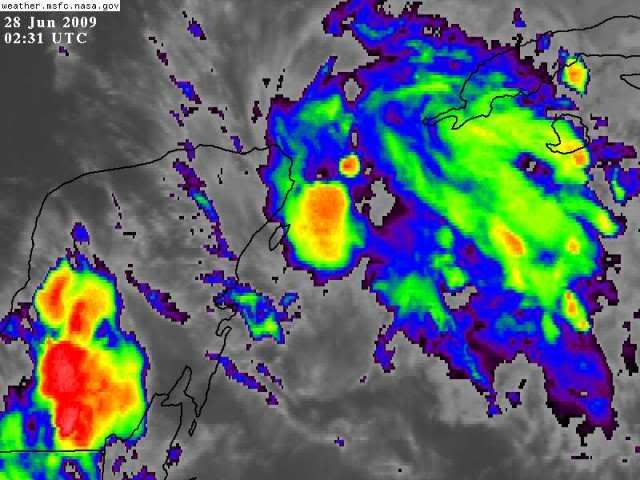
Waiting for the next burst. Don't be deceived by looks. Center is east of Cozumel on shortwave IR.
0 likes   

dolebot_Broward_NW
Category 2
Category 2
Posts: 529
Joined: Fri Sep 10, 2004 6:38 am

Re: ATL : INVEST 93L

#374 Postby dolebot_Broward_NW » Sat Jun 27, 2009 10:56 pm

I've never found it advantageous to use IR to locate the center. I did however just refresh the AVN IR image after having left it a few hours - and also came to the same conclusion. :x
0 likes   

Rainband

Re: Re:

#375 Postby Rainband » Sat Jun 27, 2009 11:08 pm

ROCK wrote:
HURAKAN wrote:Image

Until it makes landfall somewhere it needs to be watched. Just remember how bad TD 1 looked the night before it developed. Never say never in the tropics.


Remember Humberto....he didnt get his act together until appraoching the coast. That radar loop of him coming into Boilvar is an awesome spectacle. To see a system ramp up to a cat 1 in such a fast pace on radar is something...
read WXman 57s posts. Cant punch through a high. This will most likely be a "threat" to sw fl to Mississippi, meaning rain :D
0 likes   

Aric Dunn
Category 5
Category 5
Posts: 21228
Age: 41
Joined: Sun Sep 19, 2004 9:58 pm
Location: Ready for the Chase.
Contact:

#376 Postby Aric Dunn » Sat Jun 27, 2009 11:16 pm

The only closed low is at the 700 mb level per the latest Discussion.. if that can work down to the surface ( need to maintain convection) then anything is fair game.. by no means is it dead .. systems do this all time every year and some develop and some dont ..
0 likes   

User avatar
ROCK
Category 5
Category 5
Posts: 9254
Age: 53
Joined: Tue Aug 17, 2004 7:30 am
Location: Kemah, Texas

Re: Re:

#377 Postby ROCK » Sat Jun 27, 2009 11:24 pm

Rainband wrote:
ROCK wrote:
HURAKAN wrote:Image

Until it makes landfall somewhere it needs to be watched. Just remember how bad TD 1 looked the night before it developed. Never say never in the tropics.


Remember Humberto....he didnt get his act together until appraoching the coast. That radar loop of him coming into Boilvar is an awesome spectacle. To see a system ramp up to a cat 1 in such a fast pace on radar is something...
read WXman 57s posts. Cant punch through a high. This will most likely be a "threat" to sw fl to Mississippi, meaning rain :D


I agree....never said Texas in either of my posts... :lol: .....just making a point that systems like this could pull a Humberto as it approaches the coast...whatever coast that might be....
0 likes   

Rainband

Re: Re:

#378 Postby Rainband » Sun Jun 28, 2009 12:18 am

ROCK wrote:
Rainband wrote:
ROCK wrote:
Until it makes landfall somewhere it needs to be watched. Just remember how bad TD 1 looked the night before it developed. Never say never in the tropics.


Remember Humberto....he didnt get his act together until appraoching the coast. That radar loop of him coming into Boilvar is an awesome spectacle. To see a system ramp up to a cat 1 in such a fast pace on radar is something...
read WXman 57s posts. Cant punch through a high. This will most likely be a "threat" to sw fl to Mississippi, meaning rain :D


I agree....never said Texas in either of my posts... :lol: .....just making a point that systems like this could pull a Humberto as it approaches the coast...whatever coast that might be....
Sorry :lol: I misread the Humberto reference. Been a Looonnngg day :lol:

Johnathan
0 likes   

User avatar
Evil Jeremy
S2K Supporter
S2K Supporter
Posts: 5459
Age: 31
Joined: Mon Apr 10, 2006 2:10 pm
Location: Los Angeles, CA

Re: ATL : INVEST 93L

#379 Postby Evil Jeremy » Sun Jun 28, 2009 12:36 am

The only future I see for this system is bringing more rain to parts of FL. Sure, we know that amazing things can come out of nowhere in the gulf like Humberto, but this is a sheared mess at this point. There is little convection with the system, and if it keeps on this track, it might not even warrent a code yellow soon. This thing needs to get its act together big time tomorrow if it wants a tropical future.
0 likes   

floridasun78
Category 5
Category 5
Posts: 3755
Joined: Sun May 17, 2009 10:16 pm
Location: miami fl

Re: ATL : INVEST 93L

#380 Postby floridasun78 » Sun Jun 28, 2009 12:50 am

we need to see what it do when it get over gulf that should happen soon by late morning
0 likes   


Return to “2009”

Who is online

Users browsing this forum: No registered users and 12 guests