Coral Sea: HAMISH - Tropical Cyclone
Moderator: S2k Moderators


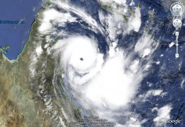
Now a Cat 3 Severe Tropical Cyclone at 65 kt (90 kt gusts) from BoM. Dvorak is T4.5 from ABRF.
IDQ20018
TROPICAL CYCLONE TECHNICAL BULLETIN: AUSTRALIA - EASTERN REGION
Issued by BRISBANE TROPICAL CYCLONE WARNING CENTRE
at: 1218 UTC 06/03/2009
Name: Severe Tropical Cyclone Hamish
Identifier: 17U
Data At: 1200 UTC
Latitude: 15.4S
Longitude: 147.2E
Location Accuracy: within 20 nm [37 km]
Movement Towards: south southeast [161 deg]
Speed of Movement: 6 knots [11 km/h]
Maximum 10-Minute Wind: 65 knots [120 km/h]
Maximum 3-Second Wind Gust: 90 knots [165 km/h]
Central Pressure: 970 hPa
Radius of 34-knot winds NE quadrant: 110 nm [205 km]
Radius of 34-knot winds SE quadrant: 110 nm [205 km]
Radius of 34-knot winds SW quadrant: 110 nm [205 km]
Radius of 34-knot winds NW quadrant: 110 nm [205 km]
Radius of 48-knot winds NE quadrant: 45 nm [85 km]
Radius of 48-knot winds SE quadrant: 45 nm [85 km]
Radius of 48-knot winds SW quadrant: 45 nm [85 km]
Radius of 48-knot winds NW quadrant: 45 nm [85 km]
Radius of 64-knot winds: 25 nm [46 km]
Radius of Maximum Winds: 25 nm
Dvorak Intensity Code: T4.5/4.5/D1.5/24HRS
Pressure of outermost isobar: 1004 hPa
Radius of outermost closed isobar: 145 nm [270 km]
Storm Depth: Deep
FORECAST DATA
Date/Time : Location : Loc. Accuracy: Max Wind : Central Pressure
[UTC] : degrees : nm [km]: knots[km/h]: hPa
+12: 07/0000: 16.7S 147.7E: 050 [095]: 080 [145]: 964
+24: 07/1200: 18.0S 148.7E: 080 [150]: 085 [155]: 962
+36: 08/0000: 19.1S 149.6E: 110 [210]: 085 [155]: 959
+48: 08/1200: 20.5S 150.2E: 145 [270]: 085 [155]: 959
+60: 09/0000: 21.4S 150.5E: 190 [355]: 085 [155]: 957
+72: 09/1200: 21.9S 149.9E: 240 [445]: 085 [155]: 957
REMARKS:
OW eye embedded in LG with B surrounding ring. DT is 5.0. MET is 4.5. MET used
as final T. SSE movement expected to continue with mid level ridge to E and
trough over the Australian continent dominant steering mechanisms.
Copyright Commonwealth of Australia
==
The next bulletin for this system will be issued by: 06/1900 UTC by Brisbane
TCWC.
0 likes
-
HURAKAN

- Professional-Met

- Posts: 46084
- Age: 39
- Joined: Thu May 20, 2004 4:34 pm
- Location: Key West, FL
- Contact:
Australian Government Bureau of Meteorology
Queensland
Tropical Cyclone Warning Centre
Media: The Standard Emergency Warning Signal should NOT be used with this
warning.
TOP PRIORITY
TROPICAL CYCLONE ADVICE NUMBER 9
Issued by the Bureau of Meteorology, Brisbane
Issued at 10:36pm on Friday the 6th of March 2009
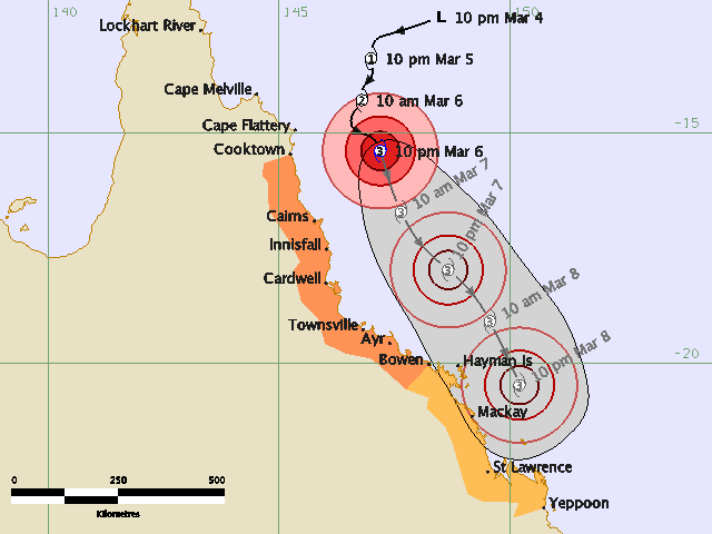
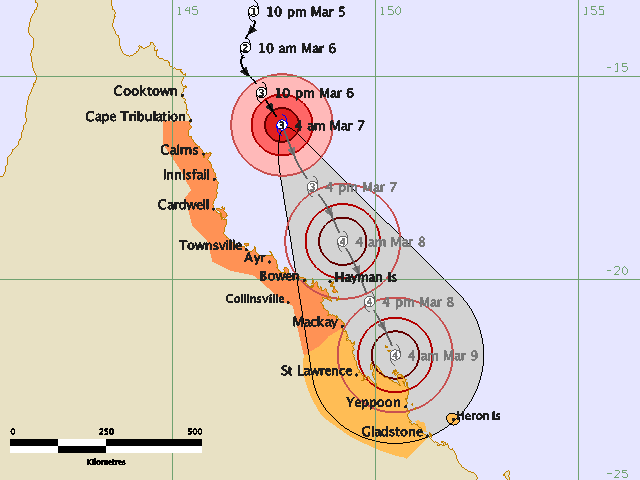
A Cyclone WARNING is now current for coastal and island communities from
Cooktown to Bowen. A Cyclone WATCH is current for coastal and island communities
from Bowen to Yeppoon.
The Cyclone WARNING between Cape Flattery and Cooktown has been CANCELLED.
Severe Tropical Cyclone Hamish, a category 3 cyclone, is located in the
northwestern Coral Sea and at 10:00 pm EST was estimated to be 210 kilometres
east of Cooktown and 230 kilometres northeast of Cairns, moving south southeast
at 11 kilometres per hour.
Severe Tropical Cyclone Hamish is expected to continue moving south southeast
parallel to the coast. Damaging wind gusts may affect coastal and island
communities between Cooktown and Bowen during the next 24 hours.
Damaging wind gusts may develop about coastal and island communities between
Bowen and Yeppoon within 24 to 48 hours.
As the cyclone moves southward, sea levels are expected to be elevated above the
normal tide along the coastline south of the cyclone. Large waves may produce
minor flooding along the foreshore. People living in areas likely to be affected
by this flooding should take measures to protect their property as much as
possible and be prepared to help their neighbours.
Areas of heavy rainfall can be expected between Cooktown and Townsville, with a
Flood Warning current for coastal rivers and streams.
Details of Severe Tropical Cyclone Hamish at 10:00 pm EST:
.Centre located near...... 15.4 degrees South 147.2 degrees East
.Location accuracy........ within 37 kilometres
.Recent movement.......... towards the south southeast at 11 kilometres per hour
.Wind gusts near centre... 165 kilometres per hour
.Severity category........ 3
.Central pressure......... 970 hectoPascals
People between Cooktown and Bowen should immediately commence or continue
preparations, especially securing boats and property.
People between Bowen and Yeppoon should consider what action they will need to
take if the cyclone threat increases. If you are unsure about the actions to be
taken, information is available from your local government or local State
Emergency Service.
The next advice will be issued by 2:00 am EST Saturday 07 March.
This warning is also available through TV and Radio Broadcasts; the Bureau's
website at http://www.bom.gov.au or call 1300 659 212. The Bureau and the State
Emergency Service would appreciate this warning being broadcast regularly.
Queensland
Tropical Cyclone Warning Centre
Media: The Standard Emergency Warning Signal should NOT be used with this
warning.
TOP PRIORITY
TROPICAL CYCLONE ADVICE NUMBER 9
Issued by the Bureau of Meteorology, Brisbane
Issued at 10:36pm on Friday the 6th of March 2009
A Cyclone WARNING is now current for coastal and island communities from
Cooktown to Bowen. A Cyclone WATCH is current for coastal and island communities
from Bowen to Yeppoon.
The Cyclone WARNING between Cape Flattery and Cooktown has been CANCELLED.
Severe Tropical Cyclone Hamish, a category 3 cyclone, is located in the
northwestern Coral Sea and at 10:00 pm EST was estimated to be 210 kilometres
east of Cooktown and 230 kilometres northeast of Cairns, moving south southeast
at 11 kilometres per hour.
Severe Tropical Cyclone Hamish is expected to continue moving south southeast
parallel to the coast. Damaging wind gusts may affect coastal and island
communities between Cooktown and Bowen during the next 24 hours.
Damaging wind gusts may develop about coastal and island communities between
Bowen and Yeppoon within 24 to 48 hours.
As the cyclone moves southward, sea levels are expected to be elevated above the
normal tide along the coastline south of the cyclone. Large waves may produce
minor flooding along the foreshore. People living in areas likely to be affected
by this flooding should take measures to protect their property as much as
possible and be prepared to help their neighbours.
Areas of heavy rainfall can be expected between Cooktown and Townsville, with a
Flood Warning current for coastal rivers and streams.
Details of Severe Tropical Cyclone Hamish at 10:00 pm EST:
.Centre located near...... 15.4 degrees South 147.2 degrees East
.Location accuracy........ within 37 kilometres
.Recent movement.......... towards the south southeast at 11 kilometres per hour
.Wind gusts near centre... 165 kilometres per hour
.Severity category........ 3
.Central pressure......... 970 hectoPascals
People between Cooktown and Bowen should immediately commence or continue
preparations, especially securing boats and property.
People between Bowen and Yeppoon should consider what action they will need to
take if the cyclone threat increases. If you are unsure about the actions to be
taken, information is available from your local government or local State
Emergency Service.
The next advice will be issued by 2:00 am EST Saturday 07 March.
This warning is also available through TV and Radio Broadcasts; the Bureau's
website at http://www.bom.gov.au or call 1300 659 212. The Bureau and the State
Emergency Service would appreciate this warning being broadcast regularly.
0 likes


-
HURAKAN
- Professional-Met
- Posts: 46084
- Age: 39
- Joined: Thu May 20, 2004 4:34 pm
- Location: Key West, FL
- Contact:
Australian Government Bureau of Meteorology
Queensland
Tropical Cyclone Warning Centre
Media: The Standard Emergency Warning Signal should NOT be used with this
warning.
TOP PRIORITY
TROPICAL CYCLONE ADVICE NUMBER 10
Issued by the Bureau of Meteorology, Brisbane
Issued at 1:42am on Saturday the 7th of March 2009
A Cyclone WARNING remains current for coastal and island communities from
Cooktown to Bowen. A Cyclone WATCH remains current for coastal and island
communities from Bowen to Yeppoon.
Severe Tropical Cyclone Hamish, a category 3 cyclone, is located in the
northwestern Coral Sea and at 1:00 am EST was estimated to be 245 kilometres
east of Cooktown and 215 kilometres east northeast of Cairns, moving south
southeast at 14 kilometres per hour.
Severe Tropical Cyclone Hamish is expected to continue moving south southeast
parallel to the coast while deepening. Damaging wind gusts may affect coastal
and island communities between Cooktown and Bowen during the next 24 hours.
Damaging wind gusts may develop about coastal and island communities between
Bowen and Yeppoon within 24 to 48 hours.
As the cyclone moves southward and deepens, sea levels are expected to be
elevated above the normal tide along the coastline south of the cyclone. Large
waves may produce minor flooding along the foreshore. People living in areas
likely to be affected by this flooding should take measures to protect their
property as much as possible and be prepared to help their neighbours.
Areas of heavy rainfall can be expected between Cooktown and Townsville, with a
Flood Warning current for coastal rivers and streams.
Details of Severe Tropical Cyclone Hamish at 1:00 am EST:
.Centre located near...... 15.9 degrees South 147.5 degrees East
.Location accuracy........ within 19 kilometres
.Recent movement.......... towards the south southeast at 14 kilometres per hour
.Wind gusts near centre... 185 kilometres per hour
.Severity category........ 3
.Central pressure......... 968 hectoPascals
People between Cooktown and Bowen should immediately commence or continue
preparations, especially securing boats and property.
People between Bowen and Yeppoon should consider what action they will need to
take if the cyclone threat increases. If you are unsure about the actions to be
taken, information is available from your local government or local State
Emergency Service.
The next advice will be issued by 5:00 am EST Saturday 07 March.
This warning is also available through TV and Radio Broadcasts; the Bureau's
website at http://www.bom.gov.au or call 1300 659 212. The Bureau and the State
Emergency Service would appreciate this warning being broadcast regularly.
0 likes
-
HURAKAN
- Professional-Met
- Posts: 46084
- Age: 39
- Joined: Thu May 20, 2004 4:34 pm
- Location: Key West, FL
- Contact:

WTPS31 PGTW 061500
SUBJ: TROPICAL CYCLONE 18P (HAMISH) WARNING NR 003
1. TROPICAL CYCLONE 18P (HAMISH) WARNING NR 003
01 ACTIVE TROPICAL CYCLONE IN SOUTHPAC
MAX SUSTAINED WINDS BASED ON ONE-MINUTE AVERAGE
---
WARNING POSITION:
061200Z --- NEAR 15.5S 147.2E
MOVEMENT PAST SIX HOURS - 155 DEGREES AT 07 KTS
POSITION ACCURATE TO WITHIN 040 NM
POSITION BASED ON EYE FIXED BY A COMBINATION OF
SATELLITE, RADAR AND SYNOPTIC DATA
PRESENT WIND DISTRIBUTION:
MAX SUSTAINED WINDS - 080 KT, GUSTS 100 KT
WIND RADII VALID OVER OPEN WATER ONLY
RADIUS OF 064 KT WINDS - 020 NM NORTHEAST QUADRANT
020 NM SOUTHEAST QUADRANT
020 NM SOUTHWEST QUADRANT
020 NM NORTHWEST QUADRANT
RADIUS OF 050 KT WINDS - 035 NM NORTHEAST QUADRANT
035 NM SOUTHEAST QUADRANT
030 NM SOUTHWEST QUADRANT
030 NM NORTHWEST QUADRANT
RADIUS OF 034 KT WINDS - 070 NM NORTHEAST QUADRANT
070 NM SOUTHEAST QUADRANT
060 NM SOUTHWEST QUADRANT
060 NM NORTHWEST QUADRANT
REPEAT POSIT: 15.5S 147.2E
---
FORECASTS:
12 HRS, VALID AT:
070000Z --- 16.9S 148.0E
MAX SUSTAINED WINDS - 090 KT, GUSTS 110 KT
WIND RADII VALID OVER OPEN WATER ONLY
RADIUS OF 064 KT WINDS - 020 NM NORTHEAST QUADRANT
020 NM SOUTHEAST QUADRANT
020 NM SOUTHWEST QUADRANT
020 NM NORTHWEST QUADRANT
RADIUS OF 050 KT WINDS - 035 NM NORTHEAST QUADRANT
035 NM SOUTHEAST QUADRANT
030 NM SOUTHWEST QUADRANT
030 NM NORTHWEST QUADRANT
RADIUS OF 034 KT WINDS - 085 NM NORTHEAST QUADRANT
085 NM SOUTHEAST QUADRANT
075 NM SOUTHWEST QUADRANT
075 NM NORTHWEST QUADRANT
VECTOR TO 24 HR POSIT: 150 DEG/ 08 KTS
---
24 HRS, VALID AT:
071200Z --- 18.3S 148.8E
MAX SUSTAINED WINDS - 095 KT, GUSTS 115 KT
WIND RADII VALID OVER OPEN WATER ONLY
RADIUS OF 064 KT WINDS - 020 NM NORTHEAST QUADRANT
020 NM SOUTHEAST QUADRANT
020 NM SOUTHWEST QUADRANT
020 NM NORTHWEST QUADRANT
RADIUS OF 050 KT WINDS - 040 NM NORTHEAST QUADRANT
040 NM SOUTHEAST QUADRANT
035 NM SOUTHWEST QUADRANT
035 NM NORTHWEST QUADRANT
RADIUS OF 034 KT WINDS - 085 NM NORTHEAST QUADRANT
085 NM SOUTHEAST QUADRANT
075 NM SOUTHWEST QUADRANT
075 NM NORTHWEST QUADRANT
VECTOR TO 36 HR POSIT: 150 DEG/ 08 KTS
---
36 HRS, VALID AT:
080000Z --- 19.6S 149.6E
MAX SUSTAINED WINDS - 100 KT, GUSTS 125 KT
WIND RADII VALID OVER OPEN WATER ONLY
RADIUS OF 064 KT WINDS - 025 NM NORTHEAST QUADRANT
025 NM SOUTHEAST QUADRANT
025 NM SOUTHWEST QUADRANT
025 NM NORTHWEST QUADRANT
RADIUS OF 050 KT WINDS - 045 NM NORTHEAST QUADRANT
045 NM SOUTHEAST QUADRANT
040 NM SOUTHWEST QUADRANT
040 NM NORTHWEST QUADRANT
RADIUS OF 034 KT WINDS - 095 NM NORTHEAST QUADRANT
095 NM SOUTHEAST QUADRANT
085 NM SOUTHWEST QUADRANT
085 NM NORTHWEST QUADRANT
VECTOR TO 48 HR POSIT: 150 DEG/ 08 KTS
---
EXTENDED OUTLOOK:
48 HRS, VALID AT:
081200Z --- 21.0S 150.4E
MAX SUSTAINED WINDS - 095 KT, GUSTS 115 KT
WIND RADII VALID OVER OPEN WATER ONLY
RADIUS OF 064 KT WINDS - 030 NM NORTHEAST QUADRANT
030 NM SOUTHEAST QUADRANT
030 NM SOUTHWEST QUADRANT
030 NM NORTHWEST QUADRANT
RADIUS OF 050 KT WINDS - 050 NM NORTHEAST QUADRANT
050 NM SOUTHEAST QUADRANT
045 NM SOUTHWEST QUADRANT
045 NM NORTHWEST QUADRANT
RADIUS OF 034 KT WINDS - 100 NM NORTHEAST QUADRANT
100 NM SOUTHEAST QUADRANT
090 NM SOUTHWEST QUADRANT
090 NM NORTHWEST QUADRANT
---
REMARKS:
061500Z POSITION NEAR 15.8S 147.4E.
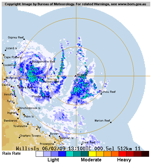
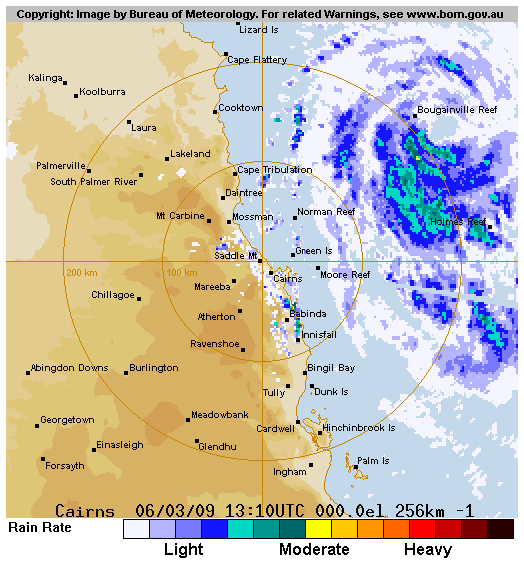
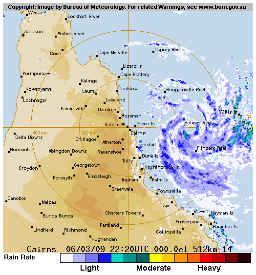
TROPICAL CYCLONE (TC) 18P (HAMISH), LOCATED APPROXIMATELY 120 NM
NORTHEAST OF THE CAIRNS, AUSTRALIA HAS TRACKED SOUTH-SOUTHEASTWARD
AT 07 KNOTS OVER THE PAST 06 HOURS. ANIMATED INFRARED SATELLITE
IMAGERY INDICATES THAT THE SYSTEM HAS CONTINUED TO CONSOLIDATE AND
HAS RECENTLY DEVELOPED A 25 NM EYE. THERE IS HIGH CONFIDENCE IN THE
CURRENT POSITION AND MOTION BASED ON THE WELL-DEFINED EYE EVIDENT ON
THE CAIRNS RADAR IMAGERY. TC 18P PASSED ABOUT 10 NM EAST OF BOUGAIN-
VILLE REEF NEAR 05/12Z WITH MAXIMUM SUSTAINED SURFACE WINDS REPORTED
AT 53 KNOTS AND MINIMUM SLP OF 979.0 MB. TC 18P HAS CONTINUED TO
RAPIDLY INTENSIFY OVER THE PAST 12 HOURS WITH A 50 KNOT INCREASE
OVER THE PAST 24 HOURS. THE CURRENT INTENSITY IS BASED ON DVORAK
ESTIMATES OF 77 KNOTS FROM PGTW AND ABRF. ANIMATED WATER VAPOR
IMAGERY CONTINUES TO INDICATE RADIAL OUTFLOW WITH STRONG POLEWARD
OUTFLOW ENHANCED BY MIDLATITUDE WESTERLIES SOUTH OF THE SYSTEM.
THE SYSTEM IS LOCATED WITHIN A FAVORABLE ENVIRONMENT WITH WEAK
VERTICAL WIND SHEAR, WARM SST > 28C AND DEEP MOISTURE. TC 18P IS
FORECAST TO TRACK SOUTH-SOUTHEASTWARD UNDER THE STEERING INFLUENCE
OF THE MID-LEVEL SUBTROPICAL RIDGE POSITIONED EAST OF THE SYSTEM.
THE AVAILABLE DYNAMIC AIDS ARE IN GOOD AGREEMENT WITH THIS TRACK.
TC 18P SHOULD CONTINUE TO INTENSIFY THROUGH TAU 36 BUT IS EXPECTED
TO WEAKEN SLIGHTLY AT TAU 48 DUE TO INCREASING VERTICAL WIND SHEAR
AND INTERACTION WITH LAND. MAXIMUM SIGNIFICANT WAVE HEIGHT AT
061200Z IS 15 FEET. NEXT WARNINGS AT 070300Z AND 071500Z.
0 likes

Re:
HURAKAN wrote:06/1430 UTC 15.9S 147.6E T5.0/5.0 HAMISH -- Southwest Pacific
90 knots.
PGTW 1730Z was also T5.0.
The eye is passing over Holmes Reef. At 18Z reported winds (in or near the southern eyewall) were 72 kt (10-min). At 20Z pressure (in the eye) was 961.0.
Update: at 21Z, 77 kt 10-min winds in the northwestern eyewall.
And both KNES and PGTW 2030Z Dvorak estimates were T5.5, so will likely be 100 kt (1-min) for JT's 07/0000Z operational intensity. Was 35 kt 30 hours earlier.
Last edited by margiek on Fri Mar 06, 2009 5:47 pm, edited 2 times in total.
0 likes
-
HURAKAN
- Professional-Met
- Posts: 46084
- Age: 39
- Joined: Thu May 20, 2004 4:34 pm
- Location: Key West, FL
- Contact:

TPPS10 PGTW 062113
A. TROPICAL CYCLONE 18P (HAMISH)
B. 06/2030Z
C. 16.7S
D. 148.1
E. THREE/MTSAT
F. T5.5/5.5/D2.5/24HRS STT: D0.5/03HRS
G. IR/EIR
H. REMARKS: 09A/PBO RAGGED EYE/ANMTN. RAGGED EYE. DT COMES OUT
TO 5.5 WITH A BLACK SURROUNDING AND WHITE EYE TEMP. RAPID MET IS
4.5. PT SUPPORTS 5.5. DBO DT AND PT.
I. ADDITIONAL POSITIONS:
06/1518Z 16.1S 147.6E MMHS
06/1529Z 15.8S 147.4E AMSR
SMITH
0 likes
-
HURAKAN
- Professional-Met
- Posts: 46084
- Age: 39
- Joined: Thu May 20, 2004 4:34 pm
- Location: Key West, FL
- Contact:
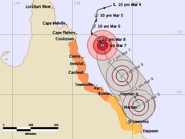
TROPICAL CYCLONE ADVICE NUMBER 11
Issued by the Bureau of Meteorology, Brisbane
Issued at 4:56am on Saturday the 7th of March 2009
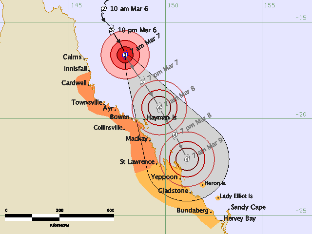
A Cyclone WARNING remains current for coastal and island communities from Cape
Tribulation to Mackay. A Cyclone WATCH is current for coastal and island
communities from Mackay to Gladstone including Heron Island.
Severe Tropical Cyclone Hamish, a category 3 cyclone, is located in the
northwestern Coral Sea and at 4:00 am EST was estimated to be 220 kilometres
east northeast of Cairns and 355 kilometres north northeast of Townsville,
moving south southeast at 14 kilometres per hour.
Severe Tropical Cyclone Hamish is expected to continue moving south southeast
parallel to the coast while deepening.
Damaging wind gusts may affect coastal and island communities between Cape
Tribulation and Mackay during the next 24 hours.
DESTRUCTIVE WINDS may affect coastal and island communities between Ayr and
Proserpine, including the Whitsunday islands, early on Sunday morning.
Damaging wind gusts may develop about coastal and island communities between
Mackay and Gladstone [including Heron Island] within 24 to 48 hours.
As the cyclone moves southward and deepens, sea levels are expected to be
elevated above the normal tide along the coastline south of the cyclone. Large
waves may produce minor flooding along the foreshore. People living in areas
likely to be affected by this flooding should take measures to protect their
property as much as possible and be prepared to help their neighbours.
Areas of heavy rainfall can be expected about the Herbert and Burdekin, and
northern parts of the Central Coast districts. A Flood Warning is current for
coastal rivers and streams.
Details of Severe Tropical Cyclone Hamish at 4:00 am EST:
.Centre located near...... 16.2 degrees South 147.7 degrees East
.Location accuracy........ within 19 kilometres
.Recent movement.......... towards the south southeast at 14 kilometres per hour
.Wind gusts near centre... 205 kilometres per hour
.Severity category........ 3
.Central pressure......... 966 hectoPascals
People between Cape Tribulation and Mackay should immediately commence or
continue preparations, especially securing boats and property.
People between Mackay and Gladstone should consider what action they will need
to take if the cyclone threat increases. If you are unsure about the actions to
be taken, information is available from your local government or local State
Emergency Service.
The next advice will be issued by 8:00 am EST Saturday 07 March.
This warning is also available through TV and Radio Broadcasts; the Bureau's
website at http://www.bom.gov.au or call 1300 659 212. The Bureau and the State
Emergency Service would appreciate this warning being broadcast regularly.
Issued by the Bureau of Meteorology, Brisbane
Issued at 4:56am on Saturday the 7th of March 2009
A Cyclone WARNING remains current for coastal and island communities from Cape
Tribulation to Mackay. A Cyclone WATCH is current for coastal and island
communities from Mackay to Gladstone including Heron Island.
Severe Tropical Cyclone Hamish, a category 3 cyclone, is located in the
northwestern Coral Sea and at 4:00 am EST was estimated to be 220 kilometres
east northeast of Cairns and 355 kilometres north northeast of Townsville,
moving south southeast at 14 kilometres per hour.
Severe Tropical Cyclone Hamish is expected to continue moving south southeast
parallel to the coast while deepening.
Damaging wind gusts may affect coastal and island communities between Cape
Tribulation and Mackay during the next 24 hours.
DESTRUCTIVE WINDS may affect coastal and island communities between Ayr and
Proserpine, including the Whitsunday islands, early on Sunday morning.
Damaging wind gusts may develop about coastal and island communities between
Mackay and Gladstone [including Heron Island] within 24 to 48 hours.
As the cyclone moves southward and deepens, sea levels are expected to be
elevated above the normal tide along the coastline south of the cyclone. Large
waves may produce minor flooding along the foreshore. People living in areas
likely to be affected by this flooding should take measures to protect their
property as much as possible and be prepared to help their neighbours.
Areas of heavy rainfall can be expected about the Herbert and Burdekin, and
northern parts of the Central Coast districts. A Flood Warning is current for
coastal rivers and streams.
Details of Severe Tropical Cyclone Hamish at 4:00 am EST:
.Centre located near...... 16.2 degrees South 147.7 degrees East
.Location accuracy........ within 19 kilometres
.Recent movement.......... towards the south southeast at 14 kilometres per hour
.Wind gusts near centre... 205 kilometres per hour
.Severity category........ 3
.Central pressure......... 966 hectoPascals
People between Cape Tribulation and Mackay should immediately commence or
continue preparations, especially securing boats and property.
People between Mackay and Gladstone should consider what action they will need
to take if the cyclone threat increases. If you are unsure about the actions to
be taken, information is available from your local government or local State
Emergency Service.
The next advice will be issued by 8:00 am EST Saturday 07 March.
This warning is also available through TV and Radio Broadcasts; the Bureau's
website at http://www.bom.gov.au or call 1300 659 212. The Bureau and the State
Emergency Service would appreciate this warning being broadcast regularly.
0 likes
-
HURAKAN
- Professional-Met
- Posts: 46084
- Age: 39
- Joined: Thu May 20, 2004 4:34 pm
- Location: Key West, FL
- Contact:
TROPICAL CYCLONE ADVICE NUMBER 12
Issued by the Bureau of Meteorology, Brisbane
Issued at 8:02am on Saturday the 7th of March 2009
A Cyclone WARNING is current for coastal and island communities from Innisfail
to St Lawrence. A Cyclone WATCH is current for coastal and island communities
from St Lawrence to Hervey Bay, including Heron Island and the Bunker Group.
The Cyclone warning has been CANCELLED between Cape Tribulation and Innisfail.
Severe Tropical Cyclone Hamish, a category 3 cyclone, is located in the
northwestern Coral Sea and at 7:00 am EST was estimated to be 230 kilometres
east of Cairns and 310 kilometres north northeast of Townsville, moving south
southeast at 17 kilometres per hour.
Severe Tropical Cyclone Hamish is expected to continue moving south southeast
parallel to the coast while deepening.
Damaging wind gusts may affect coastal and island communities between Innisfail
and St Lawrence during the next 24 hours.
DESTRUCTIVE WINDS may develop about coastal and island communities between Ayr
and Proserpine [including the Whitsunday islands] early on Sunday morning, and
extend south to St Lawrence during the day.
Damaging wind gusts may develop about coastal and island communities between St
Lawrence and Hervey Bay [including Heron Island and the Bunker Group] within 24
to 48 hours.
As the cyclone moves southward and deepens, sea levels are expected to be
elevated above the normal tide along the coastline south of the cyclone. Large
waves may produce minor flooding along the foreshore. People living in areas
likely to be affected by this flooding should take measures to protect their
property as much as possible and be prepared to help their neighbours.
Areas of heavy rainfall may cause stream rises and possible flooding between
Townsville and Mackay during the next 24 hours.
Details of Severe Tropical Cyclone Hamish at 7:00 am EST:
.Centre located near...... 16.7 degrees South 147.9 degrees East
.Location accuracy........ within 19 kilometres
.Recent movement.......... towards the south southeast at 17 kilometres per hour
.Wind gusts near centre... 220 kilometres per hour
.Severity category........ 3
.Central pressure......... 960 hectoPascals
People between Innisfail and St Lawrence should immediately commence or continue
preparations, especially securing boats and property.
People between St Lawrence and Hervey Bay should consider what action they will
need to take if the cyclone threat increases. If you are unsure about the
actions to be taken, information is available from your local government or
local State Emergency Service.
The next advice will be issued by 11:00 am EST Saturday 07 March.
This warning is also available through TV and Radio Broadcasts; the Bureau's
website at http://www.bom.gov.au or call 1300 659 212. The Bureau and the State
Emergency Service would appreciate this warning being broadcast regularly.
0 likes


-
Grifforzer
- Category 1

- Posts: 418
- Joined: Thu Feb 26, 2009 11:27 pm
Who is online
Users browsing this forum: No registered users and 42 guests