#408 Postby cycloneye » Wed Sep 09, 2009 7:50 am
WHXX01 KWBC 091243
CHGHUR
TROPICAL CYCLONE GUIDANCE MESSAGE
NWS TPC/NATIONAL HURRICANE CENTER MIAMI FL
1243 UTC WED SEP 9 2009
DISCLAIMER...NUMERICAL MODELS ARE SUBJECT TO LARGE ERRORS.
PLEASE REFER TO NHC OFFICIAL FORECASTS FOR TROPICAL CYCLONE
AND SUBTROPICAL CYCLONE INFORMATION.
ATLANTIC OBJECTIVE AIDS FOR
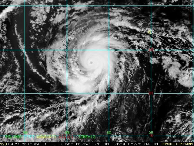
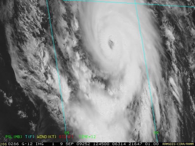
TROPICAL CYCLONE FRED (AL072009) 20090909 1200 UTC
...00 HRS... ...12 HRS... ...24 HRS. .. ...36 HRS...
090909 1200 090910 0000 090910 1200 090911 0000
LAT LON LAT LON LAT LON LAT LON
BAMS 13.5N 32.1W 14.8N 34.5W 15.6N 36.6W 15.8N 37.8W
BAMD 13.5N 32.1W 14.7N 33.9W 15.8N 35.3W 17.2N 35.9W
BAMM 13.5N 32.1W 14.5N 34.1W 15.3N 35.5W 16.1N 36.0W
LBAR 13.5N 32.1W 14.8N 33.8W 16.2N 35.7W 17.8N 37.0W
SHIP 105KTS 110KTS 103KTS 93KTS
DSHP 105KTS 110KTS 103KTS 93KTS
...48 HRS... ...72 HRS... ...96 HRS. .. ..120 HRS...
090911 1200 090912 1200 090913 1200 090914 1200
LAT LON LAT LON LAT LON LAT LON
BAMS 15.3N 38.2W 13.4N 38.1W 12.2N 37.2W 12.4N 38.1W
BAMD 18.5N 35.7W 21.4N 33.3W 26.0N 32.9W 28.9N 32.5W
BAMM 16.5N 35.8W 17.2N 33.4W 19.8N 33.0W 23.2N 34.9W
LBAR 18.7N 37.3W 21.4N 37.7W 24.9N 35.4W 28.5N 32.1W
SHIP 81KTS 56KTS 32KTS 17KTS
DSHP 81KTS 56KTS 32KTS 17KTS
...INITIAL CONDITIONS...
LATCUR = 13.5N LONCUR = 32.1W DIRCUR = 300DEG SPDCUR = 11KT
LATM12 = 12.3N LONM12 = 30.1W DIRM12 = 300DEG SPDM12 = 11KT
LATM24 = 11.8N LONM24 = 28.0W
WNDCUR = 105KT RMAXWD = 10NM WNDM12 = 70KT
CENPRS = 958MB OUTPRS = 1010MB OUTRAD = 200NM SDEPTH = D
RD34NE = 100NM RD34SE = 100NM RD34SW = 30NM RD34NW = 60NM
0 likes