ATL : TROPICAL DEPRESSION IDA
Moderator: S2k Moderators
-
Dean4Storms
- S2K Supporter

- Posts: 6358
- Age: 63
- Joined: Sun Aug 31, 2003 1:01 pm
- Location: Miramar Bch. FL
Re: ATL : TROPICAL STORM IDA
attallaman wrote:I've had a few heavy wind gusts since my last post but now it's back to just steady moderate to heavy rain, not much wind, right now 21mph from the NE, gusting to 35.
I think it is about that here in Mobile. 20-25mph sustained winds, gusting up to 35 (although I do think there was one of 42mph). If it goes more east of us, I suppose we will see heavier winds due to the pressure gradient. Who knows..at this point, it doesn't really make a difference...
0 likes
-
gatorcane

- S2K Supporter
- Posts: 23708
- Age: 48
- Joined: Sun Mar 13, 2005 3:54 pm
- Location: Boca Raton, FL
Re: ATL : TROPICAL STORM IDA
ozonepete wrote:Ida's been almost completely absorbed now into a large, developing low pressure on the east side of the 500mb trough. Doesn't even look like any strong convection is left, although everyone should stay on their guard.
yeah looks more like a frontal low with trailing cold front across the Eastern GOM. Not tropical looking at all.
Good news for us in peninsula FL is that this thing will help usher in some NW windflow and drier and cooler air once it gets NE of the peninsula. That will be a nice welcome change.
0 likes


Re: ATL : TROPICAL STORM IDA
First time I've seen my local NWS Office use this graphic.

I love when storms do this. I'd rather have 80mph winds for a few hours over listening to tornado reports.
AREA FORECAST DISCUSSION
NATIONAL WEATHER SERVICE JACKSONVILLE FL
259 PM EST MON NOV 9 2009
...WINDY WITH PERIODS OF RAIN FROM T.C. IDA THROUGH THURSDAY...
.SHORT TERM...TONIGHT THROUGH THURSDAY...
REST OF THIS AFTERNOON...DEEP EASTERLY FLOW WILL KEEP BRZY/WINDY
CONDS IN PLACE WITH LAKE WIND ADVISORY CONDS CONTINUING ACRS NERN
FL. ISOLD SHOWERS CONTINUE TO POP UP OVER THE LAND AREAS WHILE THEY
HAVE BECOME MORE SCATTERED OVER THE COASTAL WATERS. HAVE UPDATED
ZFP/GRIDS TO REFLECT THIS TREND.
TONIGHT...T.C. IDA WILL TRACK NORTH TOWARD THE GULF COAST OVERNIGHT.
MAIN RAINBAND WILL CONTINUE TO REMAIN JUST WEST OF THE FORECAST AREA
OVER THE NERN GOMEX AND THE PANHANDLE...ALTHOUGH A SLIGHT TRANSLATION
EASTWARD INTO THE SUWANNEE RIVER VALLEY AND INLD SERN GA TOWARD
MORNING WITH LIGHT TO MODERATE RAINS PUSHING INTO THAT REGION. MIN
TEMPS WILL REMAIN MILD IN THE 60S TO LOWER 70S OVERNIGHT. WINDS WILL
WEAKEN A BIT AFTER SUNSET...BUT GENERALLY REMAIN BREEZY AT 15 MPH
WITH GUSTS TO 25 MPH AT TIMES.
TUESDAY...WEAKENING REMNANT LOW OF T.C. IDA WILL SLOWLY DRIFT
EASTWARD ALONG THE PANHANDLE AND PUSH HEAVY RAINBAND INTO INLD SERN
GA AND THE SUWANNEE RIVER VALLEY WITH ISOLD EMBEDDED TSTMS AND PSBL
ISOLD TORNADIC ACTIVITY LATE IN THE DAY. SOUTHERLY FLOW AHEAD OF
THIS RAINBAND WILL CONTINUE TO PUMP MAX TEMPS INTO THE UPPER 70S TO
LOWER 80S ACRS NERN FL WITH LOWER TO MID 70S ACRS SERN GA. BREEZY
SELY WINDS AT 15 TO 20 MPH WITH HIGHER GUSTS EXPECTED THROUGHOUT THE
DAY. CONDS WILL BE CLOSE TO LAKE WIND ADVISORY LEVELS AND WILL LET
MID SHIFT ISSUE WITH NEXT PACKAGE IF NEEDED.
TUESDAY NIGHT...REMNANT LOW WILL CONTINUE TO DRIFT EASTWARD INTO THE
BIG BEND REGION AND SUWANNEE RIVER VALLEY AND LOCALLY HEAVY RAINFALL
IS POSSIBLE ALONG AND NORTH OF THIS SYSTEM WITH STORM TOTAL AMOUNTS
OF 1 TO 2 INCHES ACRS NERN FL AND 2 TO 4 INCHES POSSIBLE ACRS SERN
GA THROUGH THURSDAY. ISOLD EMBEDDED TSTMS WITH PSBL TORNADIC
ACTIVITY WILL REMAIN POSSIBLE THROUGH THE NIGHT ACRS NERN FL. MIN
TEMPS WILL REMAIN IN THE 60S IN RAIN COOLER AIR.
WEDNESDAY...TRANSITION DAY AS REMNANT LOW TRANSLATES FROM THE NERN
GOMEX INTO THE WRN ATLC JUST OFF THE NERN FL COAST. THIS WILL SHIFT
WINDS TOWARD THE NORTH LATE IN THE DAY WITH LOCALLY HEAVY RAINFALL
IN THE MORNING SHIFTING TOWARD THE I-95 CORRIDOR AND COASTAL WATERS
BY THE AFTERNOON HOURS. MAX TEMPS WILL TOP OUT ONLY A FEW DEGREES
WARMER THAN OVERNIGHT LOWS IN THE UPPER 60S TO LOWER 70S. ANY SVR
THREAT OF TSTMS SHOULD END QUICKLY IN THE MORNING AS LOW TRANSLATES
INTO THE WRN ATLC.
WEDNESDAY NIGHT...REMNANT LOW WILL DEEPEN OFF THE FLORIDA COAST AND
SEND A STRONG SURGE OF N/NELY WINDS ACRS THE REGION. LINGERING
MOISTURE ON THE BACK SIDE OF LOW WILL KEEP SCTD TO NUMEROUS SHOWERS
ACRS THE FORECAST AREA. NLY WINDS WILL BECOME QUITE STRONG ALONG THE
COAST WITH 20 TO 30 MPH SUSTAINED WINDS EXPECTED AND LESS AS YOU
MOVE INLAND.
THURSDAY...LOW OFF THE FLORIDA COAST WILL SLOWLY DRIFT SOUTHEAST
TOWARD THE BAHAMAS AND ONLY SCATTERED LIGHT RAIN SHOWERS WILL LINGER
ACRS THE FORECAST AREA...MAINLY ALONG THE COAST. BREEZY TO WINDY
N/NE FLOW WILL KEEP WIND ADVISORIES UP ALONG THE COAST AND WILL KEEP
MAX TEMPS IN THE MID/UPPER 60S.
I love when storms do this. I'd rather have 80mph winds for a few hours over listening to tornado reports.
0 likes
-
AJC3

- Admin

- Posts: 4156
- Age: 62
- Joined: Tue Aug 31, 2004 7:04 pm
- Location: Ballston Spa, New York
- Contact:
Re: ATL : TROPICAL STORM IDA
gatorcane wrote:ozonepete wrote:Ida's been almost completely absorbed now into a large, developing low pressure on the east side of the 500mb trough. Doesn't even look like any strong convection is left, although everyone should stay on their guard.
yeah looks more like a frontal low with trailing cold front across the Eastern GOM. Not tropical looking at all.
Just to be clear...that convective band across the eastern GOMEX is definitely not frontal...more of an artifact of the dry punch that wrapped around the east side of Ida.
0 likes
-
gatorcane
- S2K Supporter
- Posts: 23708
- Age: 48
- Joined: Sun Mar 13, 2005 3:54 pm
- Location: Boca Raton, FL
Re: ATL : TROPICAL STORM IDA
AJC3 wrote:gatorcane wrote:ozonepete wrote:Ida's been almost completely absorbed now into a large, developing low pressure on the east side of the 500mb trough. Doesn't even look like any strong convection is left, although everyone should stay on their guard.
yeah looks more like a frontal low with trailing cold front across the Eastern GOM. Not tropical looking at all.
Just to be clear...that convective band across the eastern GOMEX is definitely not frontal...more of an artifact of the dry punch that wrapped around the east side of Ida.
Yes of course, just has that appearance of a front. It's not of course. Point is that Ida now looks like a frontal low.
0 likes

Re: ATL : TROPICAL STORM IDA
AJC3 wrote:gatorcane wrote:ozonepete wrote:Ida's been almost completely
absorbed now into a large, developing low pressure on the east side of
the 500mb trough. Doesn't even look like any strong convection is left,
although everyone should stay on their guard.
yeah looks more like a frontal low with trailing cold front across the Eastern GOM. Not tropical looking at all.
Just
to be clear...that convective band across the eastern GOMEX is
definitely not frontal...more of an artifact of the dry punch that
wrapped around the east side of Ida.
any thoughts how much eastward progress that convective band in the eastern GOMEX will make? Love to get some rain out of that here in Palm Beach County
0 likes
-
wxman57

- Moderator-Pro Met

- Posts: 23175
- Age: 68
- Joined: Sat Jun 21, 2003 8:06 pm
- Location: Houston, TX (southwest)
Re: ATL : TROPICAL STORM IDA
Blown_away wrote:Ida's legacy will be its impact on El Salvador. Fortunately for the Gulf coast Ida was mostly a dud.
That wasn't Ida that caused the rain in El Salvador. It was Invest 96E tracking northward out of the East Pac.
0 likes
-
ozonepete
- Professional-Met

- Posts: 4743
- Joined: Mon Sep 07, 2009 3:23 pm
- Location: From Ozone Park, NYC / Now in Brooklyn, NY
Re: ATL : TROPICAL STORM IDA
AJC3 wrote:Just to be clear...that convective band across the eastern GOMEX is definitely not frontal...more of an artifact of the dry punch that wrapped around the east side of Ida.
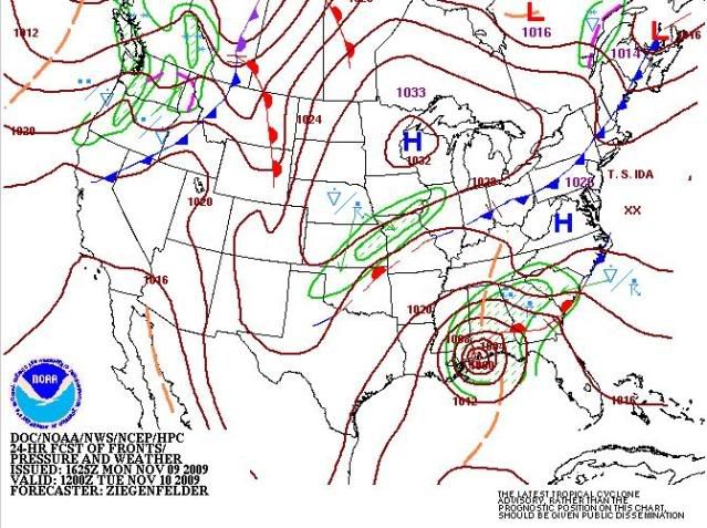
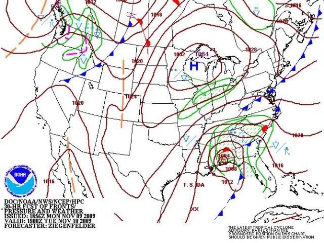
Yes, that's important. But it is a precursor to a real front during the final extratropical transition. Here's the HPC surface forecast maps for tomorrow morning and afternoon. They may be a little behind the action, but they show how that area that looks lke a front but isn't will gradually become one as it goes from an upper level trough to a surface trough to a cold front.
0 likes
-
wxman57
- Moderator-Pro Met
- Posts: 23175
- Age: 68
- Joined: Sat Jun 21, 2003 8:06 pm
- Location: Houston, TX (southwest)
Re: ATL : TROPICAL STORM IDA
lostsole wrote:WXMAN,
I have already recorded 42 mph winds sustained earlier today on Pcola pier, and 38 got a bit ago on my roof.
I didn't ask about wind on your roof or at some pier with a marine exposure. Just Pensacola airport (PNS) and Mobile Airport (MOB). Here are obs for the past 12 hours. Pensacola had 20 G36 (kts) this afternoon and Mobile had 22 gusting 29 kts. But I'm really talking about obs overnight as Ida passes not what some shower produced earlier today.
KPNS| |100119|64.0F|64.0F|100.0%|050|010|018|29.91|999|OVC|Heavy Rain , Mist
KPNS| |100106|64.0F|64.0F|100.0%|050|010|020|29.91|999|OVC|Heavy Rain , Mist
KPNS| |100053|64.9F|64.0F|96.9%|040|010|021|29.91|999|OVC|Rain , Mist
KPNS| |100007|66.0F|64.0F|93.9%|050|020|036|29.93|999|OVC|Light Rain , Mist
KPNS| |100000|66.0F|64.0F|93.9%|050|014|023|29.93|999|OVC|Light Rain , Mist
KMOB| |100126|64.0F|62.0F|93.9%|020|021|029|29.95|999|OVC|Heavy Rain , Mist
KMOB| |100118|64.0F|62.0F|93.9%|030|022|029|29.96|999|OVC|Heavy Rain , Mist
KMOB| |100056|64.9F|62.1F|90.4%|020|021|028|29.96|999|OVC|Heavy Rain , Mist
KMOB| |100003|64.0F|62.0F|93.9%|030|020|027|29.97|999|OVC|Heavy Rain , Mist
Last edited by wxman57 on Mon Nov 09, 2009 8:37 pm, edited 1 time in total.
0 likes
-
wxman57
- Moderator-Pro Met
- Posts: 23175
- Age: 68
- Joined: Sat Jun 21, 2003 8:06 pm
- Location: Houston, TX (southwest)
Re: ATL : TROPICAL STORM IDA
ozonepete wrote:AJC3 wrote:Just to be clear...that convective band across the eastern GOMEX is definitely not frontal...more of an artifact of the dry punch that wrapped around the east side of Ida.
Yes, that's important. But it is a precursor to a real front during the final extratropical transition. Here's the HPC surface forecast maps for tomorrow morning and afternoon. They may be a little behind the action, but they show how that area that looks lke a front but isn't will gradually become one as it goes from an upper level trough to a surface trough to a cold front.
http://i189.photobucket.com/albums/z174 ... -1012Z.jpg
http://i189.photobucket.com/albums/z174 ... -1018Z.jpg
I was going to mention the same thing. Surface obs indicate a frontal boundary forming south of Ida and wrapping into the storm this evening.
0 likes
-
AJC3
- Admin
- Posts: 4156
- Age: 62
- Joined: Tue Aug 31, 2004 7:04 pm
- Location: Ballston Spa, New York
- Contact:
Re: ATL : TROPICAL STORM IDA
wxman57 wrote:ozonepete wrote:AJC3 wrote:Just to be clear...that convective band across the eastern GOMEX is definitely not frontal...more of an artifact of the dry punch that wrapped around the east side of Ida.
Yes, that's important. But it is a precursor to a real front during the final extratropical transition. Here's the HPC surface forecast maps for tomorrow morning and afternoon. They may be a little behind the action, but they show how that area that looks lke a front but isn't will gradually become one as it goes from an upper level trough to a surface trough to a cold front.
http://i189.photobucket.com/albums/z174 ... -1012Z.jpg
http://i189.photobucket.com/albums/z174 ... -1018Z.jpg
I was going to mention the same thing. Surface obs indicate a frontal boundary forming south of Ida and wrapping into the storm this evening.
Right, but it's certainly not, nor will it be related to the convective band to the east. The frontogenesis is taking place well west and northwest of that feature.
0 likes
-
Dean4Storms
- S2K Supporter
- Posts: 6358
- Age: 63
- Joined: Sun Aug 31, 2003 1:01 pm
- Location: Miramar Bch. FL


Re: ATL : TROPICAL STORM IDA
Here is the highest wind and lowest pressure I could find by scouring the buoy data. It is the buoy about 20 miles south of orange beach (halfway between Mobile and P'Cola). Pressure 29.78 falling rapidly, winds sustained 35 kts gusting to 45 kts. Seems like the circulation center has turned E-NE and while broadening, may not make landfall for some time.
http://www.ndbc.noaa.gov/show_plot.php?station=42012&meas=wdpr&uom=E&time_diff=-6&time_label=CST
http://www.ndbc.noaa.gov/show_plot.php?station=42012&meas=wdpr&uom=E&time_diff=-6&time_label=CST
0 likes
-
Dean4Storms
- S2K Supporter
- Posts: 6358
- Age: 63
- Joined: Sun Aug 31, 2003 1:01 pm
- Location: Miramar Bch. FL
-
tolakram
- Admin
- Posts: 20186
- Age: 62
- Joined: Sun Aug 27, 2006 8:23 pm
- Location: Florence, KY (name is Mark)
Re: ATL : TROPICAL STORM IDA

0 likes
M a r k
- - - - -
Join us in chat: Storm2K Chatroom Invite. Android and IOS apps also available.
The posts in this forum are NOT official forecasts and should not be used as such. Posts are NOT endorsed by any professional institution or STORM2K.org. For official information and forecasts, please refer to NHC and NWS products.

Re: ATL : TROPICAL STORM IDA
wxman57 wrote:Blown_away wrote:Ida's legacy will be its impact on El Salvador. Fortunately for the Gulf coast Ida was mostly a dud.
That wasn't Ida that caused the rain in El Salvador. It was Invest 96E tracking northward out of the East Pac.
Actually Ida caused the first rains when it was crossing Central America and began to saturate the ground with water then 96-E produced the heavy rains that caused the disaster, so both of them are to blame. One thing to note is that the mateorological agency always made the reports with the title "Ida and a low pressure on the Pacific will produced rains on the country" or "hurricane Ida becomes a cat 2 and the low pressure on the Pacific will come closer to the coast" so locally Ida is in part guilty and that will be a name that, although it may not be retired, it won't be forgotten by us.
0 likes
-
attallaman
Re: ATL : TROPICAL STORM IDA
Here's a video link of a recent update from WDSU TV6 out of NOLA posted on Twitter. WDSU TV6 has been providing excellent on air coverage of Ida all day today.
http://www.wdsu.com/video/21566690/index.html
http://www.wdsu.com/video/21566690/index.html
0 likes
-
Dave

- Retired Staff

- Posts: 13442
- Age: 75
- Joined: Tue Aug 01, 2006 3:57 pm
- Location: Milan Indiana
- Contact:
Recon mission in progress..AF 304
URNT15 KNHC 100158
AF304 0811A IDA HDOB 11 20091110
015100 2826N 08904W 8435 01513 0041 +176 +047 251030 031 033 003 00
015130 2827N 08903W 8430 01517 0039 +177 +047 248031 031 035 003 00
015200 2828N 08901W 8424 01523 0036 +180 +047 248032 032 036 001 00
015230 2830N 08900W 8433 01512 0034 +180 +048 250033 033 034 004 03
015300 2831N 08859W 8432 01508 0030 +184 +050 250035 036 035 004 03
015330 2833N 08858W 8433 01507 0027 +184 +052 251037 038 036 003 00
015400 2835N 08857W 8433 01504 0023 +185 +053 253039 039 036 003 00
015430 2836N 08857W 8432 01506 0018 +190 +055 258038 038 039 004 00
015500 2838N 08856W 8434 01500 0018 +187 +056 256038 038 038 004 00
015530 2840N 08855W 8440 01494 0015 +189 +056 256035 036 036 004 00
015600 2842N 08855W 8435 01496 0011 +190 +057 258034 035 035 002 00
015630 2843N 08854W 8434 01494 0006 +193 +057 261035 035 033 001 00
015700 2845N 08853W 8436 01490 0008 +189 +057 263032 033 034 003 00
015730 2847N 08853W 8433 01492 0000 +198 +058 268030 032 035 003 00
015800 2848N 08852W 8430 01492 9996 +202 +058 268033 034 034 003 00
015830 2850N 08851W 8428 01492 9991 +207 +059 265034 035 033 004 00
015900 2851N 08851W 8425 01490 9984 +209 +060 260034 036 032 002 00
015930 2853N 08850W 8432 01482 9981 +210 +061 260034 035 031 003 03
020000 2855N 08849W 8429 01482 9980 +208 +061 259031 032 017 003 03
020030 2857N 08849W 8433 01476 9977 +210 +062 253028 028 015 003 00
$$
;
0 likes
-
AJC3
- Admin
- Posts: 4156
- Age: 62
- Joined: Tue Aug 31, 2004 7:04 pm
- Location: Ballston Spa, New York
- Contact:
Re: ATL : TROPICAL STORM IDA
jpigott wrote: any thoughts how much eastward progress that convective band in the eastern GOMEX will make? Love to get some rain out of that here in Palm Beach County
Well, as I see it, that feature is primarily being kept going by strong low level convergence. Winds inside of that dry slot to the west have weakened, while there is brisk easterly flow blowing into it, being fed by the high to the north. I would think that convective band might weaken some as low level flow begins to veer/subside en masse across the eastern GOMEX and FL, however there is a large slug of high PWAT air associated with this band, and eventually a surface cold front developing to the west will catch up to this area, and convection will likely refire late TUE through WED (since you're in WPB, the best shot for showers/storms will be WED). I see the forecast for your areas shows 50% TUE night and 60% WED with rain, possibly heavy at times, in the ZFP verbiage.
0 likes
Who is online
Users browsing this forum: No registered users and 51 guests