ATL : TROPICAL DEPRESSION ERIKA (06L)
Moderator: S2k Moderators
-
HURAKAN

- Professional-Met

- Posts: 46084
- Age: 39
- Joined: Thu May 20, 2004 4:34 pm
- Location: Key West, FL
- Contact:
530
URNT15 KNHC 032017
AF304 0506A ERIKA HDOB 24 20090903
200700 1737N 06301W 9763 00298 0101 +230 +120 127024 025 025 000 00
200730 1739N 06301W 9762 00298 0102 +230 +120 128025 025 023 000 00
200800 1741N 06301W 9761 00300 0102 +230 +119 125026 026 024 000 00
200830 1743N 06301W 9764 00297 0102 +230 +118 124025 026 024 000 03
200900 1745N 06301W 9763 00297 0101 +230 +117 124024 025 025 000 00
200930 1747N 06301W 9764 00296 0101 +230 +116 120025 025 999 999 03
201000 1748N 06303W 9761 00298 0102 +230 +116 117022 024 999 999 03
201030 1746N 06304W 9766 00295 0100 +230 +115 116021 021 999 999 03
201100 1745N 06305W 9763 00296 0100 +231 +115 118021 022 026 000 03
201130 1744N 06307W 9764 00295 0099 +231 +115 120021 022 026 000 00
201200 1743N 06308W 9768 00292 0100 +235 +114 123021 021 026 000 00
201230 1741N 06309W 9756 00298 0097 +235 +113 122019 020 025 000 03
201300 1740N 06311W 9767 00290 0097 +238 +113 132020 022 021 000 03
201330 1739N 06312W 9758 00297 0096 +235 +114 134021 022 020 000 03
201400 1738N 06312W 9761 00296 0097 +235 +114 130018 019 999 999 03
201430 1736N 06313W 9769 00289 0097 +235 +115 123020 022 999 999 03
201500 1736N 06315W 9760 00296 0096 +235 +115 123024 024 999 999 03
201530 1737N 06317W 9761 00292 0093 +236 +116 131027 028 999 999 03
201600 1739N 06316W 9764 00290 0093 +238 +116 145024 028 999 999 03
201630 1740N 06315W 9772 00284 0094 +238 +117 135024 026 999 999 03
$$
;
0 likes
-
wxman57

- Moderator-Pro Met

- Posts: 23175
- Age: 68
- Joined: Sat Jun 21, 2003 8:06 pm
- Location: Houston, TX (southwest)
Re: Re:
sandyb wrote:OuterBanker wrote:Sandy, you have to be a pro member. It was in his 1pm post. WE have to be carefull and interpet what he says, direct quotes would be a copyright infringment.
i am a pro member and i just read him and watched video thats why im asking cause he is not saying this on the pro site i was wondering if it was somewhere else i wanted to go read it thats all i really like to read him thats why i have to pro site but just dont see what they are saying he is saying and wanted to know if it was somewhere else
thanks again
You'd have had to been watching his Big Dog videos all week. I didn't watch today, but the wording in his text supported his comments from earlier this week about a big hurricane in the Bahamas and an East Coast threat.
I do agree that the mid level circulation area is the place to watch with Erika, regardless of whether or not it's declared a remnant low or open wave. If we saw a disturbance that looked like Erika with that kind of mid level spin we'd be very concerned about development most of the time. Most data indicate that the environment ahead of Erika's remnants would not support redevelopment (or development of the area near the MLC). However, projections of wind shear along the path of a disturbance have been known to be wrong. That's why McCoy is staying put for now.
0 likes
-
Tropics Guy

- Tropical Storm

- Posts: 167
- Age: 63
- Joined: Tue Aug 31, 2004 8:12 pm
- Location: Hallandale beach & Vero beach, FL
Re: ATL : TROPICAL STORM ERIKA (06L)
Well looks like Erika spit out her old LLC which is racing to the west, and unless a new LLC forms under the MLC near Guadeloupe Island , then I wouldn't be surprised if this degenerated into an open wave soon. Here we are 6 days from the peak of Hurricane season and all we have to talk about is a sheared system on life support and a code yellow way out east which will have to deal with SAL., been a pathetic season to date(exception Bill)! lol!!
TG
TG
0 likes
-
HenkL
- S2K Supporter

- Posts: 2401
- Joined: Fri Sep 10, 2004 5:33 pm
- Location: Groningen, The Netherlands
- Contact:
URNT15 KNHC 032026
AF304 0506A ERIKA HDOB 25 20090903
201700 1740N 06314W 9761 00293 0094 +236 +117 139025 026 999 999 03
201730 1739N 06312W 9762 00293 0095 +235 +118 139023 024 999 999 03
201800 1738N 06312W 9761 00293 0095 +235 +118 127020 021 999 999 03
201830 1737N 06313W 9767 00290 0097 +235 +118 120018 019 999 999 03
201900 1736N 06314W 9768 00290 0096 +235 +118 119020 021 999 999 03
201930 1735N 06316W 9756 00300 0095 +237 +117 129023 025 999 999 03
202000 1735N 06318W 9764 00290 0094 +239 +117 128025 025 999 999 03
202030 1735N 06320W 9755 00297 0093 +233 +117 128023 025 999 999 03
202100 1735N 06322W 9768 00287 0095 +236 +116 132022 024 999 999 03
202130 1736N 06324W 9762 00292 0095 +238 +116 131022 023 999 999 03
202200 1736N 06326W 9765 00290 0094 +239 +116 130022 023 026 000 03
202230 1736N 06328W 9762 00292 0094 +236 +117 130022 023 025 000 00
202300 1736N 06330W 9761 00291 0093 +238 +118 132023 024 026 000 03
202330 1737N 06332W 9762 00291 0093 +238 +119 134023 023 026 000 00
202400 1737N 06334W 9757 00296 0093 +236 +120 130021 022 026 000 00
202430 1737N 06336W 9755 00297 0093 +236 +120 128022 023 025 000 03
202500 1737N 06338W 9759 00292 0093 +237 +121 123021 022 025 000 00
202530 1738N 06341W 9765 00290 0093 +235 +122 118019 019 023 000 00
202600 1738N 06343W 9765 00289 0093 +236 +124 118020 021 022 000 03
202630 1738N 06345W 9763 00291 0093 +235 +124 120017 017 022 000 00
0 likes
Re: ATL : TROPICAL STORM ERIKA (06L)
Tropics Guy wrote:Well looks like Erika spit out her old LLC which is racing to the west, and unless a new LLC forms under the MLC near Guadeloupe Island , then I wouldn't be surprised if this degenerated into an open wave soon. Here we are 6 days from the peak of Hurricane season and all we have to talk about is a sheared system on life support and a code yellow way out east which will have to deal with SAL., been a pathetic season to date(exception Bill)! lol!!
TG
And I am totally ok with that!!!
0 likes
-
StormClouds63
- Category 2

- Posts: 583
- Age: 62
- Joined: Tue May 13, 2008 11:56 am
- Location: Southwest Louisiana
Re: ATL : TROPICAL STORM ERIKA (06L)
sandyb wrote:NEXT...WHO WILL WE TALK ABOUT NEXT WEEK?
Fred
Fred Flinstone
Fred and Wilma
Right Said Fred
Drop Dead Fred
Freddy Krueger
Frederick the Great
Frederic (1979)
You get the idea ...
If that Cape Verde system doesn't start firing up some convection, there will be nothing else except EPAC or CPAC.
0 likes
-
HURAKAN
- Professional-Met
- Posts: 46084
- Age: 39
- Joined: Thu May 20, 2004 4:34 pm
- Location: Key West, FL
- Contact:
Re: ATL : TROPICAL STORM ERIKA (06L)
Tropics Guy wrote:Well looks like Erika spit out her old LLC which is racing to the west, and unless a new LLC forms under the MLC near Guadeloupe Island , then I wouldn't be surprised if this degenerated into an open wave soon. Here we are 6 days from the peak of Hurricane season and all we have to talk about is a sheared system on life support and a code yellow way out east which will have to deal with SAL., been a pathetic season to date(exception Bill)! lol!!
TG
Look at it this way, it's better than in 2002!
1 Tropical Storm ARTHUR 14-16 JUL 50 997 -
2 Tropical Storm BERTHA 04-09 AUG 35 1008 -
3 Tropical Storm CRISTOBAL 05-08 AUG 40 999 -
4 Tropical Storm DOLLY 29 AUG-04 SEP 55 994 -
5 Tropical Storm EDOUARD 01-06 SEP 55 1002 -
2006:
1 Tropical Storm ALBERTO 10-14 JUN 60 995 -
2 Tropical Storm BERYL 18-21 JUL 50 1001 -
Noname
3 Tropical Storm CHRIS 01-05 AUG 55 1001 -
4 Tropical Storm DEBBY 21-27 AUG 45 1000 -
5 Hurricane ERNESTO 24 AUG-01 SEP 65 987 1
6 Hurricane FLORENCE 03-12 SEP 80 972 1
1994:
1 Tropical Storm ALBERTO 30 JUN- 7 JUL 55 993 -
2 Tropical Storm BERYL 14-19 AUG 50 1000 -
3 Hurricane CHRIS 16-23 AUG 70 979 1
1982:
1 Hurricane ALBERTO 2- 6 JUN 75 985 1
2 Subtropical Storm 1 18-20 JUN 60 984 -
3 Tropical Storm BERYL 28 AUG- 6 SEP 63 989 -
and more.
Always think that when you believe something looks bad, it could have been worse before!
0 likes
-
cycloneye

- Admin

- Posts: 149727
- Age: 69
- Joined: Thu Oct 10, 2002 10:54 am
- Location: San Juan, Puerto Rico
Re: ATL: TROPICAL STORM ERIKA Advisories Thread
000
WTNT31 KNHC 032037
TCPAT1
BULLETIN
TROPICAL DEPRESSION ERIKA ADVISORY NUMBER 9
NWS TPC/NATIONAL HURRICANE CENTER MIAMI FL AL062009
500 PM AST THU SEP 03 2009
...ERIKA WEAKENS TO A TROPICAL DEPRESSION...ALL WARNINGS
DISCONTINUED...
AT 5 PM AST...2100 UTC...ALL TROPICAL STORM WARNINGS ASSOCIATED WITH
ERIKA HAVE BEEN DISCONTINUED.
INTERESTS IN NORTHERN CARIBBEAN SEA SHOULD CONTINUE TO MONITOR THE
PROGRESS OF ERIKA.
FOR STORM INFORMATION SPECIFIC TO YOUR AREA IN THE UNITED
STATES...INCLUDING POSSIBLE INLAND WATCHES AND WARNINGS...PLEASE
MONITOR PRODUCTS ISSUED BY YOUR LOCAL NATIONAL WEATHER SERVICE
FORECAST OFFICE. FOR STORM INFORMATION SPECIFIC TO YOUR AREA
OUTSIDE OF THE UNITED STATES...PLEASE MONITOR PRODUCTS ISSUED
BY YOUR NATIONAL METEOROLOGICAL SERVICE.
AT 500 PM AST...2100 UTC...THE CENTER OF TROPICAL DEPRESSION ERIKA
WAS LOCATED NEAR LATITUDE 16.7 NORTH...LONGITUDE 65.3 WEST OR ABOUT
130 MILES...205 KM...SOUTH-SOUTHEAST OF SAN JUAN PUERTO RICO AND
ABOUT 325 MILES...525 KM...EAST-SOUTHEAST OF SANTO DOMINGO IN THE
DOMINICAN REPUBLIC.
THE DEPRESSION IS MOVING TOWARD THE WEST NEAR 12 MPH...19 KM/HR. A
TURN TOWARD THE WEST-NORTHWEST IS EXPECTED TONIGHT...AND THIS
MOTION IS EXPECTED TO CONTINUE UNTIL DISSIPATION. ON THE FORECAST
TRACK...ERIKA OR ITS REMNANTS ARE EXPECTED TO PASS SOUTH OF PUERTO
RICO TONIGHT...AND BE NEAR OR OVER HISPANIOLA ON FRIDAY.
MAXIMUM SUSTAINED WINDS ARE NEAR 35 MPH...55 KM/HR...WITH HIGHER
GUSTS. SOME WEAKENING IS FORECAST IN THE NEXT 24 HOURS...AND ERIKA
IS EXPECTED TO BECOME A REMNANT LOW ON FRIDAY. ERIKA COULD ALSO
DEGENERATE INTO A TROPICAL WAVE AT ANY TIME.
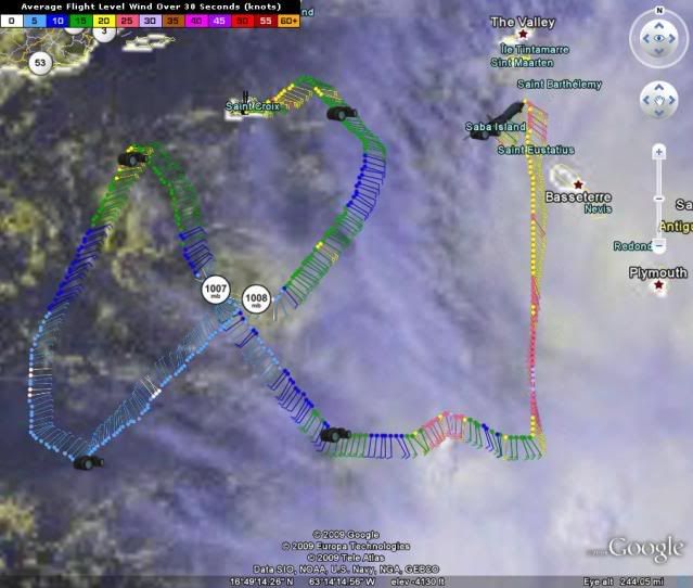
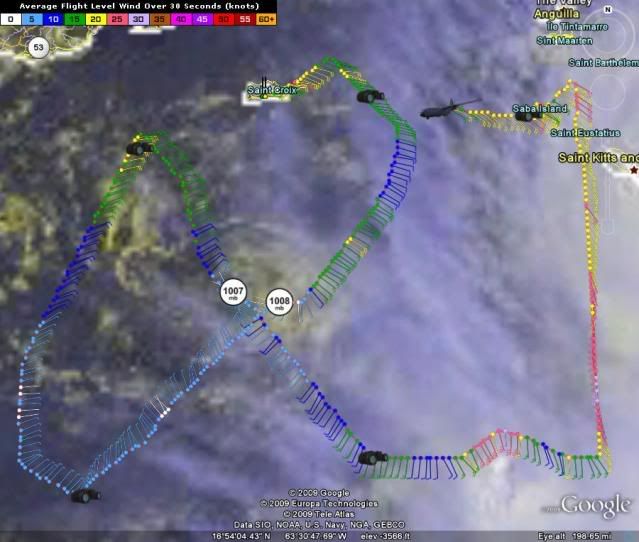
THE LATEST MINIMUM CENTRAL PRESSURE REPORTED BY AN AIR FORCE RESERVE
HURRICANE HUNTER AIRCRAFT IF 1007 MB...29.74 INCHES.
ERIKA IS EXPECTED TO PRODUCE TOTAL RAINFALL ACCUMULATIONS OF 2 TO 4
INCHES OVER THE CENTRAL AND NORTHERN LESSER ANTILLES...PUERTO
RICO...AND THE U.S. AND BRITISH VIRGIN ISLANDS...WITH ISOLATED
MAXIMUM AMOUNTS OF 6 INCHES POSSIBLE.
...SUMMARY OF 500 PM AST INFORMATION...
LOCATION...16.7N 65.3W
MAXIMUM SUSTAINED WINDS...35 MPH
PRESENT MOVEMENT...WEST OR 275 DEGREES AT 12 MPH
MINIMUM CENTRAL PRESSURE...1007 MB
THE NEXT ADVISORY WILL BE ISSUED BY THE NATIONAL HURRICANE CENTER AT
1100 PM AST.
$$
FORECASTER BRENNAN
000
WTNT41 KNHC 032038
TCDAT1
TROPICAL DEPRESSION ERIKA DISCUSSION NUMBER 9
NWS TPC/NATIONAL HURRICANE CENTER MIAMI FL AL062009
500 PM AST THU SEP 03 2009
THE CENTER OF ERIKA IS EXPOSED AS A LOW-LEVEL SWIRL MOVING OUT AHEAD
OF THE WANING DEEP CONVECTION OVER THE LEEWARD ISLANDS. THE AIR
FORCE RESERVE RECONNAISSANCE HURRICANE HUNTER AIRCRAFT FOUND A
MINIMUM PRESSURE OF 1007 MB...BUT WERE UNABLE TO FIND ANY WINDS TO
SUPPORT TROPICAL STORM STATUS. AS A RESULT...ERIKA IS DOWNGRADED TO
A TROPICAL DEPRESSION ON THIS ADVISORY.
THE INITIAL MOTION ESTIMATE IS 280/10...WELL TO THE SOUTH OF THE
PREVIOUS OFFICIAL FORECAST TRACK AND THE MAJORITY OF ALL THE MODEL
GUIDANCE. SINCE ERIKA SHOULD MOVE WITH THE LOW-LEVEL FLOW...THE
SHALLOW BAM MODEL WAS FOLLOWED CLOSELY FOR THE NEW FORECAST TRACK.
THIS FORECAST TURNS ERIKA TOWARD THE WEST-NORTHWEST...TAKING THE
CYCLONE OR ITS REMNANT LOW SOUTH OF PUERTO RICO AND OVER HISPANIOLA
...WHERE THE LOW-LEVEL CENTER WILL LIKELY DISSIPATE OVER THE RUGGED
TERRAIN IN 48 HOURS.
THE OFFICIAL FORECAST ASSUMES THAT ERIKA WILL HAVE A DIFFICULT TIME
SUSTAINING ANY DEEP CONVECTION AS IT MOVES INTO AN ENVIRONMENT OF
INCREASING SHEAR AND DRY AIR IN THE LOWER TO MID-TROPOSPHERE. ERIKA
IS MAINTAINED AS A TROPICAL DEPRESSION THROUGH 12 HOURS...AND IS
FORECAST TO BE A REMNANT LOW BY 24 HOURS....ALTHOUGH THIS COULD
OCCUR SOONER IF THE CONVECTION EAST OF THE LOW-LEVEL CENTER OVER
THE LEEWARD ISLANDS CONTINUES TO WEAKEN. IT IS ALSO POSSIBLE THAT
THE CENTER OF ERIKA COULD BECOME POORLY DEFINED AND THE CYCLONE
COULD DEVOLVE INTO A TROPICAL WAVE AT ANY TIME. EVEN IF ERIKA LOSES
TROPICAL CYCLONE STATUS...ITS REMNANTS COULD PRODUCE HEAVY RAINFALL
OVER THE GREATER ANTILLES.
FORECAST POSITIONS AND MAX WINDS
INITIAL 03/2100Z 16.7N 65.3W 30 KT
12HR VT 04/0600Z 17.2N 66.8W 30 KT
24HR VT 04/1800Z 18.1N 68.6W 25 KT...REMNANT LOW
36HR VT 05/0600Z 18.9N 70.3W 20 KT...REMNANT LOW
48HR VT 05/1800Z 19.5N 72.2W 20 KT...DISSIPATING INLAND
72HR VT 06/1800Z...DISSIPATED
$$
FORECASTER BRENNAN
WTNT31 KNHC 032037
TCPAT1
BULLETIN
TROPICAL DEPRESSION ERIKA ADVISORY NUMBER 9
NWS TPC/NATIONAL HURRICANE CENTER MIAMI FL AL062009
500 PM AST THU SEP 03 2009
...ERIKA WEAKENS TO A TROPICAL DEPRESSION...ALL WARNINGS
DISCONTINUED...
AT 5 PM AST...2100 UTC...ALL TROPICAL STORM WARNINGS ASSOCIATED WITH
ERIKA HAVE BEEN DISCONTINUED.
INTERESTS IN NORTHERN CARIBBEAN SEA SHOULD CONTINUE TO MONITOR THE
PROGRESS OF ERIKA.
FOR STORM INFORMATION SPECIFIC TO YOUR AREA IN THE UNITED
STATES...INCLUDING POSSIBLE INLAND WATCHES AND WARNINGS...PLEASE
MONITOR PRODUCTS ISSUED BY YOUR LOCAL NATIONAL WEATHER SERVICE
FORECAST OFFICE. FOR STORM INFORMATION SPECIFIC TO YOUR AREA
OUTSIDE OF THE UNITED STATES...PLEASE MONITOR PRODUCTS ISSUED
BY YOUR NATIONAL METEOROLOGICAL SERVICE.
AT 500 PM AST...2100 UTC...THE CENTER OF TROPICAL DEPRESSION ERIKA
WAS LOCATED NEAR LATITUDE 16.7 NORTH...LONGITUDE 65.3 WEST OR ABOUT
130 MILES...205 KM...SOUTH-SOUTHEAST OF SAN JUAN PUERTO RICO AND
ABOUT 325 MILES...525 KM...EAST-SOUTHEAST OF SANTO DOMINGO IN THE
DOMINICAN REPUBLIC.
THE DEPRESSION IS MOVING TOWARD THE WEST NEAR 12 MPH...19 KM/HR. A
TURN TOWARD THE WEST-NORTHWEST IS EXPECTED TONIGHT...AND THIS
MOTION IS EXPECTED TO CONTINUE UNTIL DISSIPATION. ON THE FORECAST
TRACK...ERIKA OR ITS REMNANTS ARE EXPECTED TO PASS SOUTH OF PUERTO
RICO TONIGHT...AND BE NEAR OR OVER HISPANIOLA ON FRIDAY.
MAXIMUM SUSTAINED WINDS ARE NEAR 35 MPH...55 KM/HR...WITH HIGHER
GUSTS. SOME WEAKENING IS FORECAST IN THE NEXT 24 HOURS...AND ERIKA
IS EXPECTED TO BECOME A REMNANT LOW ON FRIDAY. ERIKA COULD ALSO
DEGENERATE INTO A TROPICAL WAVE AT ANY TIME.
THE LATEST MINIMUM CENTRAL PRESSURE REPORTED BY AN AIR FORCE RESERVE
HURRICANE HUNTER AIRCRAFT IF 1007 MB...29.74 INCHES.
ERIKA IS EXPECTED TO PRODUCE TOTAL RAINFALL ACCUMULATIONS OF 2 TO 4
INCHES OVER THE CENTRAL AND NORTHERN LESSER ANTILLES...PUERTO
RICO...AND THE U.S. AND BRITISH VIRGIN ISLANDS...WITH ISOLATED
MAXIMUM AMOUNTS OF 6 INCHES POSSIBLE.
...SUMMARY OF 500 PM AST INFORMATION...
LOCATION...16.7N 65.3W
MAXIMUM SUSTAINED WINDS...35 MPH
PRESENT MOVEMENT...WEST OR 275 DEGREES AT 12 MPH
MINIMUM CENTRAL PRESSURE...1007 MB
THE NEXT ADVISORY WILL BE ISSUED BY THE NATIONAL HURRICANE CENTER AT
1100 PM AST.
$$
FORECASTER BRENNAN
000
WTNT41 KNHC 032038
TCDAT1
TROPICAL DEPRESSION ERIKA DISCUSSION NUMBER 9
NWS TPC/NATIONAL HURRICANE CENTER MIAMI FL AL062009
500 PM AST THU SEP 03 2009
THE CENTER OF ERIKA IS EXPOSED AS A LOW-LEVEL SWIRL MOVING OUT AHEAD
OF THE WANING DEEP CONVECTION OVER THE LEEWARD ISLANDS. THE AIR
FORCE RESERVE RECONNAISSANCE HURRICANE HUNTER AIRCRAFT FOUND A
MINIMUM PRESSURE OF 1007 MB...BUT WERE UNABLE TO FIND ANY WINDS TO
SUPPORT TROPICAL STORM STATUS. AS A RESULT...ERIKA IS DOWNGRADED TO
A TROPICAL DEPRESSION ON THIS ADVISORY.
THE INITIAL MOTION ESTIMATE IS 280/10...WELL TO THE SOUTH OF THE
PREVIOUS OFFICIAL FORECAST TRACK AND THE MAJORITY OF ALL THE MODEL
GUIDANCE. SINCE ERIKA SHOULD MOVE WITH THE LOW-LEVEL FLOW...THE
SHALLOW BAM MODEL WAS FOLLOWED CLOSELY FOR THE NEW FORECAST TRACK.
THIS FORECAST TURNS ERIKA TOWARD THE WEST-NORTHWEST...TAKING THE
CYCLONE OR ITS REMNANT LOW SOUTH OF PUERTO RICO AND OVER HISPANIOLA
...WHERE THE LOW-LEVEL CENTER WILL LIKELY DISSIPATE OVER THE RUGGED
TERRAIN IN 48 HOURS.
THE OFFICIAL FORECAST ASSUMES THAT ERIKA WILL HAVE A DIFFICULT TIME
SUSTAINING ANY DEEP CONVECTION AS IT MOVES INTO AN ENVIRONMENT OF
INCREASING SHEAR AND DRY AIR IN THE LOWER TO MID-TROPOSPHERE. ERIKA
IS MAINTAINED AS A TROPICAL DEPRESSION THROUGH 12 HOURS...AND IS
FORECAST TO BE A REMNANT LOW BY 24 HOURS....ALTHOUGH THIS COULD
OCCUR SOONER IF THE CONVECTION EAST OF THE LOW-LEVEL CENTER OVER
THE LEEWARD ISLANDS CONTINUES TO WEAKEN. IT IS ALSO POSSIBLE THAT
THE CENTER OF ERIKA COULD BECOME POORLY DEFINED AND THE CYCLONE
COULD DEVOLVE INTO A TROPICAL WAVE AT ANY TIME. EVEN IF ERIKA LOSES
TROPICAL CYCLONE STATUS...ITS REMNANTS COULD PRODUCE HEAVY RAINFALL
OVER THE GREATER ANTILLES.
FORECAST POSITIONS AND MAX WINDS
INITIAL 03/2100Z 16.7N 65.3W 30 KT
12HR VT 04/0600Z 17.2N 66.8W 30 KT
24HR VT 04/1800Z 18.1N 68.6W 25 KT...REMNANT LOW
36HR VT 05/0600Z 18.9N 70.3W 20 KT...REMNANT LOW
48HR VT 05/1800Z 19.5N 72.2W 20 KT...DISSIPATING INLAND
72HR VT 06/1800Z...DISSIPATED
$$
FORECASTER BRENNAN
0 likes

-
Blown Away

- S2K Supporter
- Posts: 10253
- Joined: Wed May 26, 2004 6:17 am
Re: ATL : TROPICAL DEPRESSION ERIKA (06L)
The NHC & TPC have this low N or DR in a few days, but looking at the satellite the LLC looks like it is dissipating and going to move below the DR.
0 likes
-
terrapintransit

- Category 1

- Posts: 275
- Age: 51
- Joined: Tue Sep 04, 2007 8:08 pm
- Location: Williamsport, Pa


I would like to apologize to the board members and particularly the staff of S2K for what came across disrespectfully in my post earlier today, when indeed, I am very thankful each and every season for the incredibly hard work done and the level of knowledge shared. Hopefully, that respect has come across over the years more than when I've let emotion override considerate thought.
Mea maxima culpa.
Mea maxima culpa.
0 likes
-
HURAKAN
- Professional-Met
- Posts: 46084
- Age: 39
- Joined: Thu May 20, 2004 4:34 pm
- Location: Key West, FL
- Contact:
Re: ATL : TROPICAL DEPRESSION ERIKA (06L)
terrapintransit wrote:Anybody care for a slice of this season?
There is nothing better than a day after another. Just wait a little longer and you may have to retract from that statement. Hopefully not!
It's too early to throw the towel and look the other way.
Look at the 2002 numbers that I posted above and you will see that things looked scarce until Isidore and Lili decided to pay a visit.
0 likes
-
jlauderdal
- S2K Supporter
- Posts: 7240
- Joined: Wed May 19, 2004 5:46 am
- Location: NE Fort Lauderdale
- Contact:
Re: ATL : TROPICAL DEPRESSION ERIKA (06L)
terrapintransit wrote:
Anybody care for a slice of this season?
that looks alot better than crow
0 likes
-
Typhoon_Willie

- Category 5

- Posts: 1042
- Joined: Mon Jun 09, 2003 3:19 pm
- Location: Greenacres City, Florida
-
terrapintransit
- Category 1
- Posts: 275
- Age: 51
- Joined: Tue Sep 04, 2007 8:08 pm
- Location: Williamsport, Pa
Re: ATL : TROPICAL DEPRESSION ERIKA (06L)
See shall we...I will gladly retract my burnt offering in the event of a pattern change 
0 likes
Who is online
Users browsing this forum: No registered users and 41 guests