GOM: INVEST 90L

Moderator: S2k Moderators

Message
Author
User avatar
AdamFirst
S2K Supporter
S2K Supporter
Posts: 2488
Age: 35
Joined: Thu Aug 14, 2008 10:54 am
Location: Port Saint Lucie, FL

Re: GOM: INVEST 90L - 7:45 PM EDT STWO: Between 30-50%

#421 Postby AdamFirst » Fri May 22, 2009 9:12 pm

MGC wrote: I don't want to wake up to TS warning...


Let's not get too excited now...
0 likes   

Javlin
Category 5
Category 5
Posts: 1568
Age: 63
Joined: Fri Jul 09, 2004 7:58 pm
Location: ms gulf coast

Re: GOM: INVEST 90L - 7:45 PM EDT STWO: Between 30-50%

#422 Postby Javlin » Fri May 22, 2009 9:19 pm

AdamFirst wrote:
MGC wrote: I don't want to wake up to TS warning...


Let's not get too excited now...


A little wind and little blow never hurt no one :D could be interesting,esp. if this was our blow for the season I take it with both hands ;)
0 likes   

User avatar
HURAKAN
Professional-Met
Professional-Met
Posts: 46086
Age: 37
Joined: Thu May 20, 2004 4:34 pm
Location: Key West, FL
Contact:

#423 Postby HURAKAN » Fri May 22, 2009 9:29 pm

Image
0 likes   

User avatar
JTE50
Category 1
Category 1
Posts: 336
Age: 66
Joined: Mon Jul 21, 2008 10:48 am
Location: Pensacola
Contact:

Re: GOM: INVEST 90L - 7:45 PM EDT STWO: Between 30-50%

#424 Postby JTE50 » Fri May 22, 2009 9:41 pm

[/quote] Let's not get too excited now...[/quote]

Too late for that . . . I've been filming the feeder bands all day along here in Pensacola and it sure beats Sunny boring Blue Sky !! :)
0 likes   

Ed Mahmoud

Re: GOM: INVEST 90L - 7:45 PM EDT STWO: Between 30-50%

#425 Postby Ed Mahmoud » Fri May 22, 2009 9:43 pm

Image
0 likes   

Bailey1777
S2K Supporter
S2K Supporter
Posts: 962
Joined: Mon Jul 31, 2006 6:23 pm
Location: Houston, Texas

#426 Postby Bailey1777 » Fri May 22, 2009 9:44 pm

ThankYou Hurakan that's a great way to show it(DUMMY PROOF)
0 likes   

User avatar
HURAKAN
Professional-Met
Professional-Met
Posts: 46086
Age: 37
Joined: Thu May 20, 2004 4:34 pm
Location: Key West, FL
Contact:

#427 Postby HURAKAN » Fri May 22, 2009 10:27 pm

Image
0 likes   

User avatar
tailgater
S2K Supporter
S2K Supporter
Posts: 3339
Joined: Sun Jul 11, 2004 9:13 pm
Location: St. Amant La.

Re: GOM: INVEST 90L

#428 Postby tailgater » Fri May 22, 2009 10:27 pm

Do you think that is the LLC south of Mobile
Image
Sorry I don't know how to post a loop but here's the link.
http://radar.weather.gov/radar.php?prod ... b&loop=yes
Last edited by tailgater on Fri May 22, 2009 10:32 pm, edited 1 time in total.
0 likes   

User avatar
JTE50
Category 1
Category 1
Posts: 336
Age: 66
Joined: Mon Jul 21, 2008 10:48 am
Location: Pensacola
Contact:

Re: GOM: INVEST 90L

#429 Postby JTE50 » Fri May 22, 2009 10:30 pm

GrLevel 2 Radar out of Mobile:
Image
0 likes   

Derek Ortt

#430 Postby Derek Ortt » Fri May 22, 2009 10:34 pm

added a floater on the system

http://www.nwhhc.com/satellite.html
0 likes   

User avatar
Tampa Bay Hurricane
Category 5
Category 5
Posts: 5596
Age: 36
Joined: Fri Jul 22, 2005 7:54 pm
Location: St. Petersburg, FL

#431 Postby Tampa Bay Hurricane » Fri May 22, 2009 10:54 pm

I think we will have Tropical Storm Ana by 5 AM.
There has been a really strong blow up of convection
as the system has moved into much lower shear.
Additionally, Mobile NWS radar shows very well
defined rotation about the center with heavy
convection on the North and East sides.
0 likes   

Bailey1777
S2K Supporter
S2K Supporter
Posts: 962
Joined: Mon Jul 31, 2006 6:23 pm
Location: Houston, Texas

Re: GOM: INVEST 90L

#432 Postby Bailey1777 » Fri May 22, 2009 10:59 pm

24 hours ago I would have said you were crazy, but she is making a run at it. That's the tropics for you (Never know when you might get surprised.)
0 likes   

User avatar
storm92405
Tropical Low
Tropical Low
Posts: 16
Age: 50
Joined: Sun Aug 31, 2008 3:45 pm
Location: Hackberry, LA
Contact:

Re: GOM: INVEST 90L

#433 Postby storm92405 » Fri May 22, 2009 11:02 pm

Take a look at the storm relative velocities from the Mobile radar. Definately rotation in the convection.

http://radar.weather.gov/radar.php?rid= ... 1&loop=yes
0 likes   

tolakram
Admin
Admin
Posts: 19182
Age: 60
Joined: Sun Aug 27, 2006 8:23 pm
Location: Florence, KY (name is Mark)

Re: GOM: INVEST 90L

#434 Postby tolakram » Fri May 22, 2009 11:04 pm

Wind speed climbing as pressure is dropping.

http://www.ndbc.noaa.gov/station_page.php?station=42040
Image
0 likes   

Sihara
Tropical Storm
Tropical Storm
Posts: 137
Joined: Wed Jul 16, 2008 8:39 pm
Location: St. Petersburg, FL

Re: GOM: INVEST 90L

#435 Postby Sihara » Fri May 22, 2009 11:06 pm

Could be. From the NHC:

"FOR THE NORTH ATLANTIC...CARIBBEAN SEA AND THE GULF OF MEXICO...

A BROAD AREA OF LOW PRESSURE IS CENTERED OVER THE GULF OF MEXICO
ABOUT 200 MILES SOUTH OF PENSACOLA FLORIDA. SATELLITE IMAGERY
INDICATES THAT THE ASSOCIATED SHOWERS AND THUNDERSTORMS CONTINUE TO
INCREASE THIS EVENING. ADDITIONAL DEVELOPMENT OF THIS SYSTEM IS
POSSIBLE...AND A TROPICAL DEPRESSION COULD FORM BEFORE THE LOW
MOVES INLAND OVER THE NORTHERN GULF COAST ON SATURDAY."

http://www.nhc.noaa.gov

As previously stated, the effect will be the same, named or no. Rain totals on the E. Coast are rivaling Fay's and we're seeing more people boating in the streets. Sadly, eleven people or more have perished in Haiti - an ugly start to the Season. Here at home, we've just had a badly-needed drought buster - a welcome relief from overheated temps and the threat of wildfires.

From the pictures I've seen of it, it sure has a TD look to it, just a thought.
0 likes   

User avatar
wxman57
Moderator-Pro Met
Moderator-Pro Met
Posts: 22506
Age: 66
Joined: Sat Jun 21, 2003 8:06 pm
Location: Houston, TX (southwest)

Re: GOM: INVEST 90L

#436 Postby wxman57 » Fri May 22, 2009 11:12 pm

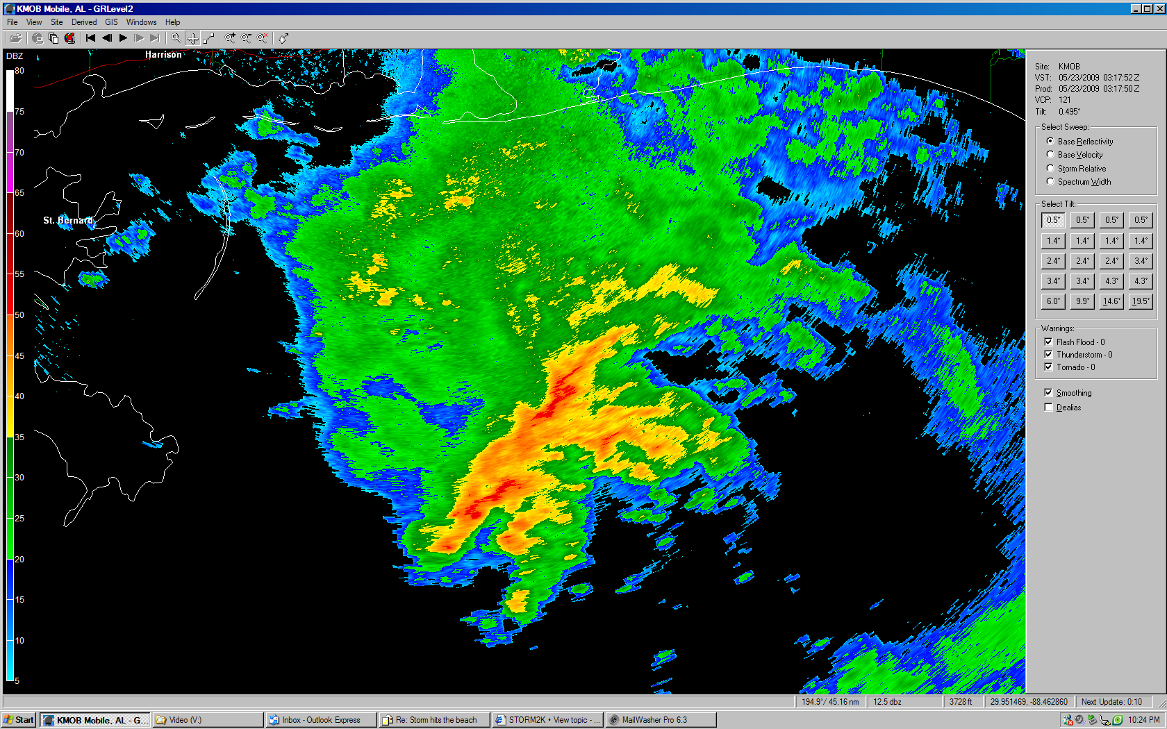
tailgater wrote:Do you think that is the LLC south of Mobile?


The low center is very broad, perhaps 100 or more miles across. Thunderstorms are forming on the northeast part of a large ring (the perimeter of the low). Buoys are reporting NE-E winds of 25-35 mph within that area of storms. Elsewhere, winds are 10-15 miles south of there.

There's no question it's a closed circulation, but it currently lacks thunderstorms near any well-defined LLC, so no upgrade tonight is likely. By tomorrow morning, the squalls should be inland into MS/AL and the low will follow, moving ashore before noon. Hopefully, the NHC will just let it move inland without overly alarming people on the coast about this rainfall event.
0 likes   

User avatar
vbhoutex
Storm2k Executive
Storm2k Executive
Posts: 28979
Age: 72
Joined: Wed Oct 09, 2002 11:31 pm
Location: Spring Branch area, Houston, TX
Contact:

Re: GOM: INVEST 90L

#437 Postby vbhoutex » Fri May 22, 2009 11:12 pm

This is Jeff Lindner's latest on 90L:
90L: TD Possible‏

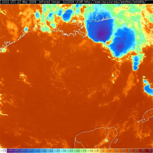
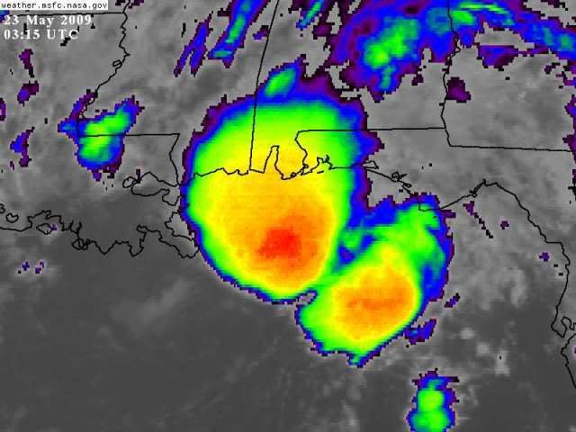
Large area of surface low pressure located 100 miles SE of the mouth of the MS River our 200 miles SSE of Pensacola, FL has developed extensive deep convection near and to the N and NE of the broad low level center.

Convection is not over the center and shear is displacing the thunderstorms to the north and NE of the center, however enough organization appears to be in progress to raise the threat that a TD may be forming.

Track:

Surface low is moving toward the WNW to NW at 5-10mph and this motion should continue with a gradual turn more toward the NW and NNW with time. This is supported by the global models and tropical guidance bringing he system toward the MS/AL/FL panhandle Saturday evening.

Intensity:

Splitting hairs between a weak TS and nothing as the difference will be a name or no name...the impacts will be the same. Main threat will be excessive flooding rainfall and gusty winds along the coast. Do not foresee much more than a 40mph TS given the appearance with all the convection removed from the center. First the convection will have to persist overnight...and then we may see something.

Impacts:

Main impacts will be flooding rainfall along and E of the track. Across TX swells are already up, and should actually start coming down as the system moves inland. Tropical moisture is spreading westward as noted by increase in PW at KLCH evening ROAB along with WSR 88D showing westward moving storms over SC LA in region of enhanced moisture and western ascent of surface flow. Expect deeper moisture to overspread the region overnight setting the stage for an active seabreeze both Saturday and Sunday and maybe into Monday.

Will keep a close eye on the low once inland over the southern US just to make sure it keeps moving northward. The system looks very much like a highly sheared...heavily eastern side biased development of convection.
0 likes   

User avatar
baygirl_1
S2K Supporter
S2K Supporter
Posts: 825
Joined: Wed Aug 11, 2004 4:06 pm
Location: Mobile, AL

Re: GOM: INVEST 90L

#438 Postby baygirl_1 » Fri May 22, 2009 11:15 pm

Well, I can tell y'all it's sure acting like something tropical. We're having bands of rain moving through: no rain--heavy downpour--no rain--heavy downpour--... I did hear some thunder this afternoon right before the dismissal bell at a school, but that was it. So, I wouldn't be surprised to see a TD or minimal TS. Regardless, we're in for a very soggy Memorial Day weekend. How dare it rain on our crawfish boils and barbecues! :)
0 likes   

User avatar
Tampa_God
Category 1
Category 1
Posts: 333
Age: 34
Joined: Wed May 31, 2006 7:27 pm
Location: New Port Richey/Trinity, FL

Re: GOM: INVEST 90L

#439 Postby Tampa_God » Fri May 22, 2009 11:20 pm

Can we call this Ana already, please! lol
0 likes   

User avatar
Category 5
Category 5
Category 5
Posts: 10074
Age: 34
Joined: Sun Feb 11, 2007 10:00 pm
Location: New Brunswick, NJ
Contact:

Re: GOM: INVEST 90L

#440 Postby Category 5 » Fri May 22, 2009 11:24 pm

Tampa_God wrote:Can we call this Ana already, please! lol


no because its not ;)
0 likes   


Return to “2009”

Who is online

Users browsing this forum: No registered users and 8 guests