ATL : INVEST 95L

Moderator: S2k Moderators

Message
Author
User avatar
Cyclenall
Category 5
Category 5
Posts: 6627
Joined: Thu Jun 08, 2006 10:01 pm
Location: Ontario, Canada

Re: ATL : INVEST 95L

#61 Postby Cyclenall » Fri Sep 04, 2009 5:10 pm

StormClouds63 wrote:
CrazyC83 wrote:It seems the consensus is for this to go poof.


This may drop dead before it ever has a chance to become Fred.

It should be called Drop Dead Fred like the movie from 1991.

There wasn't a reason why the NHC put this to medium, it just went up to that.
0 likes   

User avatar
MetroMike
Category 3
Category 3
Posts: 828
Joined: Sun Aug 29, 2004 8:13 pm
Location: Tampa Bay
Contact:

Re: ATL : INVEST 95L

#62 Postby MetroMike » Fri Sep 04, 2009 5:16 pm

Climatology suggests this shall develop....but this year I wouldn't bet the farm on it.
0 likes   

User avatar
cycloneye
Admin
Admin
Posts: 139192
Age: 67
Joined: Thu Oct 10, 2002 10:54 am
Location: San Juan, Puerto Rico

Re: ATL : Invest 95L - Computer Models

#63 Postby cycloneye » Fri Sep 04, 2009 6:33 pm

First GFDL plots only are for 48 hours.

ATTENTION...NATIONAL HURRICANE CENTER

NCEP COUPLED GFDL HURRICANE MODEL FORECAST MADE FOR

TROPICAL DEPRESSION INVEST 95L

INITIAL TIME 18Z SEP 4

DISCLAIMER ... THIS INFORMATION IS PROVIDED AS GUIDANCE. IT
REQUIRES INTERPRETATION BY HURRICANE SPECIALISTS AND SHOULD
NOT BE CONSIDERED AS A FINAL PRODUCT. PLEASE SEE THE TPC/NHC
OFFICIAL FORECAST.


FORECAST STORM POSITION

HOUR LATITUDE LONGITUDE HEADING/SPEED(KT)

0 13.7 26.1 280./19.0
6 14.2 26.2 346./ 5.0
12 15.5 27.5 315./18.2
18 16.0 29.1 288./16.8
24 16.5 29.9 300./ 8.4
30 17.2 31.6 293./17.9
36 17.7 32.6 297./10.6
42 18.5 34.1 299./16.2
48 17.8 35.9 250./18.7
0 likes   

User avatar
cycloneye
Admin
Admin
Posts: 139192
Age: 67
Joined: Thu Oct 10, 2002 10:54 am
Location: San Juan, Puerto Rico

Re: ATL : INVEST 95L

#64 Postby cycloneye » Fri Sep 04, 2009 6:34 pm

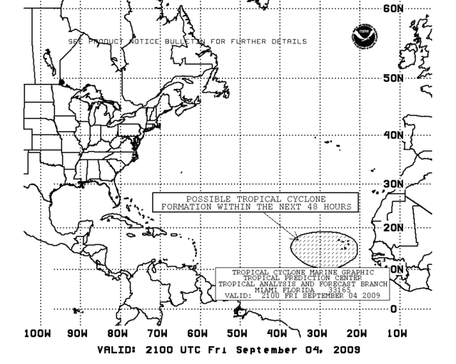
TROPICAL WEATHER OUTLOOK
NWS TPC/NATIONAL HURRICANE CENTER MIAMI FL
800 PM EDT FRI SEP 4 2009

FOR THE NORTH ATLANTIC...CARIBBEAN SEA AND THE GULF OF MEXICO...

SHOWER ACTIVITY ASSOCIATED WITH THE REMNANTS ERIKA HAS DIMINISHED.
UPPER-LEVEL WINDS ARE EXPECTED TO REMAIN HIGHLY UNFAVORABLE FOR
RE-DEVELOPMENT OF THIS SYSTEM.

AN AREA OF LOW PRESSURE ASSOCIATED WITH A TROPICAL WAVE IS LOCATED
ABOUT 175 MILES WEST-SOUTHWEST OF THE SOUTHERNMOST CAPE VERDE
ISLANDS. ALTHOUGH THE THUNDERSTORM ACTIVITY IS CURRENTLY
LIMITED...THIS SYSTEM HAS SOME POTENTIAL FOR SLOW DEVELOPMENT
DURING THE NEXT DAY OR TWO AS IT MOVES WEST OR WEST-NORTHWESTWARD
AT 15 TO 20 MPH. THERE IS A MEDIUM CHANCE...30 TO 50 PERCENT...OF
THIS SYSTEM BECOMING A TROPICAL CYCLONE DURING THE NEXT 48 HOURS.


ELSEWHERE...TROPICAL CYCLONE FORMATION IS NOT EXPECTED DURING THE
NEXT 48 HOURS.

$$
FORECASTER AVILA/KIMBERLAIN

Image
0 likes   

User avatar
Macrocane
Category 5
Category 5
Posts: 4218
Age: 35
Joined: Sun May 24, 2009 5:35 pm
Location: El Salvador

Re: ATL : INVEST 95L

#65 Postby Macrocane » Fri Sep 04, 2009 6:58 pm

'CaneFreak wrote:
StormClouds63 wrote:Noticed MJO currently unfavorable:
http://www.cpc.ncep.noaa.gov/products/p ... thly_1.gif

Any idea regarding its movement during the next couple of weeks?
Is favorable MJO any more (or less) significant during an El Nino season?


El nino and mjo arent related at all


"Intraseasonal variability in the atmosphere (wind and pressure), which is often related to the Madden-Julian Oscillation (MJO), can significantly impact surface and subsurface conditions across the Pacific Ocean." Taken from the MJO weekly update.

"Oceanic responses to relatively strong Madden-Julian Oscillations (MJOs) and background winds controlled by El Niño-Southern Oscillation (ENSO) are examined. The MJO’s arrival excites dominant downwelling and upwelling Kelvin waves during El Niño developing (pre-El Niño: PEN) and other (non-PEN) phases, respectively. These opposite signals come from background wind directions under different ENSO phases and exert opposite impacts on SST. In addition, MJO convection itself develops accompanied by larger surface wind variations during PEN phases, which can be related to the interactive amplifications of synoptic- and planetary-scale disturbances when westerly wind bursts occur. Consequently, the strength of westerly forcing and its oceanic response during PEN phases are larger than that of the corresponding easterly forcing and its response during non-PEN phases. These results suggest that modulations of MJO amplitude and structure under the background westerly and easterly winds associated with ENSO phases exert opposite but asymmetric impacts on the ocean." An abstract of a research named The Oceanic Response to the Madden-Julian Oscillation and ENSO

Back on topic, I think that if 95-L develops it will be another weakling and not-exciting storm to track, but it appears that models are in good agrrement developing a fairly strong system from the tropical wave behind 95-L, let's see what happens, maybe a similar Ana-Bill scenario will happen again.
0 likes   

clfenwi
Category 5
Category 5
Posts: 3331
Joined: Thu Jun 09, 2005 12:54 pm

Re: ATL : INVEST 95L

#66 Postby clfenwi » Fri Sep 04, 2009 6:59 pm

'CaneFreak wrote:
StormClouds63 wrote:Noticed MJO currently unfavorable:
http://www.cpc.ncep.noaa.gov/products/p ... thly_1.gif

Any idea regarding its movement during the next couple of weeks?
Is favorable MJO any more (or less) significant during an El Nino season?


El nino and mjo arent related at all


While the two aren't related, it could still be true that MJO is more significant during an El Nino than in other times.

Let us say that conditions for tropical cyclogenesis are on a scale of 0-10, where 0 means nothing forms and 10 means that a little bit of vorticity over my hot tub generates a tropical storm. Furthermore, let us say that MJO is a +/-1 contributor to this point scale.

When there are exceptionally favorable conditions, like in 2005, (whose overall conditions we'll rate as an 8 on this hypothetical scale), MJO doesn't matter that much, because even when it's in an unfavorable state, it doesn't bring down the score that much and when it is favorable, the "boost" it brings is marginal; there's already so much forming that its added benefits aren't really noticed.

However, in an El Nino, where overall conditions rate may rate 1,2 or 3, MJO becomes a big deal, as it can have a >33% effect on the score.

While, the numbers, of course, are made up, they do serve to demonstrate that anything that adds to favorable conditions is more significant the less favorable conditions are.
0 likes   

User avatar
HURAKAN
Professional-Met
Professional-Met
Posts: 46086
Age: 37
Joined: Thu May 20, 2004 4:34 pm
Location: Key West, FL
Contact:

#67 Postby HURAKAN » Fri Sep 04, 2009 7:17 pm

Image

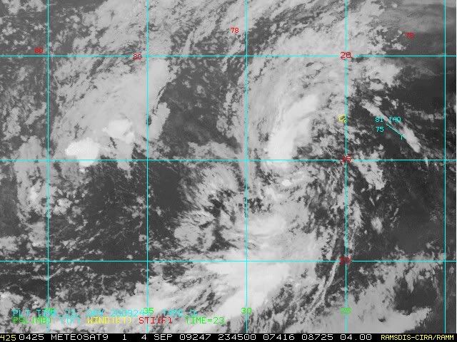
Latest.
0 likes   

User avatar
HURAKAN
Professional-Met
Professional-Met
Posts: 46086
Age: 37
Joined: Thu May 20, 2004 4:34 pm
Location: Key West, FL
Contact:

#68 Postby HURAKAN » Fri Sep 04, 2009 7:20 pm

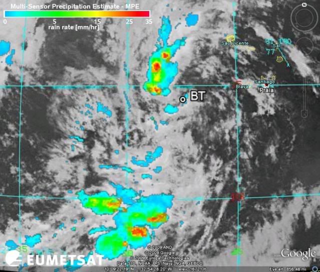
Image

:yesno: Image
0 likes   

CrazyC83
Professional-Met
Professional-Met
Posts: 33393
Joined: Tue Mar 07, 2006 11:57 pm
Location: Deep South, for the first time!

#69 Postby CrazyC83 » Fri Sep 04, 2009 7:24 pm

Its best chance will be if it can stay around 12-13°N as shear is low there. Anything north of 15°N is doomsday for it.
0 likes   

User avatar
thetruesms
Professional-Met
Professional-Met
Posts: 844
Age: 40
Joined: Thu Aug 16, 2007 1:14 pm
Location: Tallahasee, FL
Contact:

#70 Postby thetruesms » Fri Sep 04, 2009 7:28 pm

I must say, I do like that pretty curvature to it, but I'm not really liking much else at the moment. It'll be something to keep an eye on for the time being, though. 8-)
Last edited by thetruesms on Fri Sep 04, 2009 7:37 pm, edited 1 time in total.
0 likes   

User avatar
cycloneye
Admin
Admin
Posts: 139192
Age: 67
Joined: Thu Oct 10, 2002 10:54 am
Location: San Juan, Puerto Rico

Re: ATL : INVEST 95L

#71 Postby cycloneye » Fri Sep 04, 2009 7:32 pm

00 UTC Best Track

AL, 95, 2009090500, , BEST, 0, 143N, 275W, 25, 1008, DB

ftp://ftp.tpc.ncep.noaa.gov/atcf/tcweb/ ... 009.invest
0 likes   

User avatar
cycloneye
Admin
Admin
Posts: 139192
Age: 67
Joined: Thu Oct 10, 2002 10:54 am
Location: San Juan, Puerto Rico

Re: ATL : Invest 95L - Computer Models

#72 Postby cycloneye » Fri Sep 04, 2009 7:33 pm

635
WHXX01 KWBC 050020
CHGHUR
TROPICAL CYCLONE GUIDANCE MESSAGE
NWS TPC/NATIONAL HURRICANE CENTER MIAMI FL
0020 UTC SAT SEP 5 2009

DISCLAIMER...NUMERICAL MODELS ARE SUBJECT TO LARGE ERRORS.
PLEASE REFER TO NHC OFFICIAL FORECASTS FOR TROPICAL CYCLONE
AND SUBTROPICAL CYCLONE INFORMATION.

ATLANTIC OBJECTIVE AIDS FOR

DISTURBANCE INVEST (AL952009) 20090905 0000 UTC

...00 HRS... ...12 HRS... ...24 HRS. .. ...36 HRS...
090905 0000 090905 1200 090906 0000 090906 1200

LAT LON LAT LON LAT LON LAT LON
BAMS 14.3N 27.5W 15.7N 30.2W 17.0N 32.9W 18.2N 35.8W
BAMD 14.3N 27.5W 16.3N 29.9W 18.6N 31.8W 21.1N 33.1W
BAMM 14.3N 27.5W 16.0N 30.2W 17.9N 32.6W 19.8N 34.7W
LBAR 14.3N 27.5W 16.1N 30.6W 18.2N 33.2W 20.2N 35.1W
SHIP 25KTS 29KTS 34KTS 35KTS
DSHP 25KTS 29KTS 34KTS 35KTS

...48 HRS... ...72 HRS... ...96 HRS. .. ..120 HRS...
090907 0000 090908 0000 090909 0000 090910 0000

LAT LON LAT LON LAT LON LAT LON
BAMS 19.2N 38.5W 20.8N 43.0W 21.9N 46.1W 23.5N 47.1W
BAMD 23.2N 33.1W 23.3N 31.7W 21.5N 32.7W 22.2N 34.0W
BAMM 21.4N 36.4W 24.6N 38.7W 27.2N 39.7W 30.0N 38.8W
LBAR 21.6N 36.1W 23.0N 36.7W 23.1N 36.9W 24.2N 35.9W
SHIP 35KTS 30KTS 27KTS 30KTS
DSHP 35KTS 30KTS 27KTS 30KTS

...INITIAL CONDITIONS...
LATCUR = 14.3N LONCUR = 27.5W DIRCUR = 280DEG SPDCUR = 19KT
LATM12 = 13.4N LONM12 = 23.9W DIRM12 = 283DEG SPDM12 = 20KT
LATM24 = 12.7N LONM24 = 20.1W
WNDCUR = 25KT RMAXWD = 45NM WNDM12 = 20KT
CENPRS = 1008MB OUTPRS = 1011MB OUTRAD = 120NM SDEPTH = D
RD34NE = 0NM RD34SE = 0NM RD34SW = 0NM RD34NW = 0NM

Image
0 likes   

User avatar
Gustywind
Category 5
Category 5
Posts: 12334
Joined: Mon Sep 03, 2007 7:29 am
Location: Baie-Mahault, GUADELOUPE

#73 Postby Gustywind » Fri Sep 04, 2009 7:39 pm

000
AXNT20 KNHC 050002
TWDAT

TROPICAL WEATHER DISCUSSION
NWS TPC/NATIONAL HURRICANE CENTER MIAMI FL
805 PM EDT FRI SEP 04 2009

TROPICAL WEATHER DISCUSSION FOR NORTH AMERICA...CENTRAL
AMERICA...GULF OF MEXICO...CARIBBEAN SEA...NORTHERN SECTIONS OF
SOUTH AMERICA...AND ATLANTIC OCEAN TO THE AFRICAN COAST FROM THE
EQUATOR TO 32N. THE FOLLOWING INFORMATION IS BASED ON SATELLITE
IMAGERY...METEOROLOGICAL ANALYSIS...WEATHER OBSERVATIONS...AND
RADAR.

BASED ON 1800 UTC SURFACE ANALYSIS AND SATELLITE IMAGERY THROUGH
2315 UTC.

...SPECIAL FEATURES...

TROPICAL WAVE IS JUST W OF THE CAPE VERDE ISLANDS ALONG 26W S
OF 20N MOVING W AT 20 KT. A 1012 MB LOW IS EMBEDDED ON THE WAVE
AXIS NEAR 14N26W. SATELLITE IMAGERY SHOWS A LARGE CLOUD MASS
FROM 9N-21N BETWEEN 23W-31W. THE WAVE IS ALSO WITHIN A DEEP
LAYER MOISTURE MAXIMUM AS INDICATED BY THE SSMI TOTAL
PRECIPITABLE WATER IMAGERY. SCATTERED MODERATE CONVECTION IS
FROM 15N-18N BETWEEN 25W-28W...AND FROM 9N-12N BETWEEN 27W-30W.
SOME ADDITIONAL DEVELOPMENT OF THIS SYSTEM IS POSSIBLE OVER THE
NEXT COUPLE OF DAYS.


$$
FORMOSA
0 likes   

User avatar
HURAKAN
Professional-Met
Professional-Met
Posts: 46086
Age: 37
Joined: Thu May 20, 2004 4:34 pm
Location: Key West, FL
Contact:

Re: ATL : INVEST 95L

#74 Postby HURAKAN » Fri Sep 04, 2009 8:15 pm

cycloneye wrote:00 UTC Best Track

AL, 95, 2009090500, , BEST, 0, 143N, 275W, 25, 1008, DB

ftp://ftp.tpc.ncep.noaa.gov/atcf/tcweb/ ... 009.invest


Image
0 likes   

Sanibel
Category 5
Category 5
Posts: 10348
Joined: Mon Aug 30, 2004 11:06 pm
Location: Offshore SW Florida

Re: ATL : Invest 95L - Computer Models

#75 Postby Sanibel » Fri Sep 04, 2009 8:19 pm

Now we'll watch the models come west with this one probably.
0 likes   

User avatar
Evil Jeremy
S2K Supporter
S2K Supporter
Posts: 5459
Age: 30
Joined: Mon Apr 10, 2006 2:10 pm
Location: Los Angeles, CA

Re: ATL : Invest 95L - Computer Models

#76 Postby Evil Jeremy » Fri Sep 04, 2009 8:22 pm

Sanibel wrote:Now we'll watch the models come west with this one probably.


Why do you say that?
0 likes   

User avatar
HURAKAN
Professional-Met
Professional-Met
Posts: 46086
Age: 37
Joined: Thu May 20, 2004 4:34 pm
Location: Key West, FL
Contact:

Re: ATL : Invest 95L - Computer Models

#77 Postby HURAKAN » Fri Sep 04, 2009 8:25 pm

Evil Jeremy wrote:
Sanibel wrote:Now we'll watch the models come west with this one probably.


Why do you say that?


b/c the system won't probably intensity much over the next few days and weak systems tend to move west.
0 likes   

fasterdisaster
Category 5
Category 5
Posts: 1868
Joined: Mon Sep 19, 2005 4:41 pm
Location: Miami, Florida

#78 Postby fasterdisaster » Fri Sep 04, 2009 8:36 pm

It's dying a painful death. Unless dmax can ramp things up this one's a goner.
0 likes   

User avatar
HURAKAN
Professional-Met
Professional-Met
Posts: 46086
Age: 37
Joined: Thu May 20, 2004 4:34 pm
Location: Key West, FL
Contact:

Re:

#79 Postby HURAKAN » Fri Sep 04, 2009 8:51 pm

fasterdisaster wrote:It's dying a painful death. Unless dmax can ramp things up this one's a goner.


Image

Are you seeing the same storm I'm seeing? I know the road its difficult but it doesn't seem to be dying at the moment.
0 likes   

Sanibel
Category 5
Category 5
Posts: 10348
Joined: Mon Aug 30, 2004 11:06 pm
Location: Offshore SW Florida

Re: ATL : INVEST 95L

#80 Postby Sanibel » Fri Sep 04, 2009 8:59 pm

Drying out with bad structure. Agree with fasterdisaster.
0 likes   


Return to “2009”

Who is online

Users browsing this forum: No registered users and 17 guests