

I'm not sure what model is the correct one but the ECM evolution would probably show the system turning extra-tropical again anyway by 216hrs...
That being said, the 12z ECM is very similar indeed to Alma 1951 and would certainly lead to a very interesting system!
As I said before, I'm not sure what the track will do, but the ECM has done a good job and picked up the intial track before the GFS did...
ATL : INVEST 90L - COMPUTER MODELS
Moderator: S2k Moderators
0 likes
Personal Forecast Disclaimer:
The posts in this forum are NOT official forecast and should not be used as such. They are just the opinion of the poster and may or may not be backed by sound meteorological data. They are NOT endorsed by any professional institution or storm2k.org. For official information, please refer to the NHC and NWS products
The posts in this forum are NOT official forecast and should not be used as such. They are just the opinion of the poster and may or may not be backed by sound meteorological data. They are NOT endorsed by any professional institution or storm2k.org. For official information, please refer to the NHC and NWS products
-
JonathanBelles
- Professional-Met

- Posts: 11430
- Age: 35
- Joined: Sat Dec 24, 2005 9:00 pm
- Location: School: Florida State University (Tallahassee, FL) Home: St. Petersburg, Florida
- Contact:
the NCO (model) site has an new experimental site that is quite a bit different. They now offer many more views, more models, and some better maps in general. I like that with the new maps that landmasses are better outlined. I do not like that you have to click around a lot more to get around and that the links for all of the frames are so long.
Here is the new site: http://mag.ncep.noaa.gov/NCOMAGWEB/appcontroller
Here is the new site: http://mag.ncep.noaa.gov/NCOMAGWEB/appcontroller
0 likes


-
cycloneye

- Admin

- Posts: 149579
- Age: 69
- Joined: Thu Oct 10, 2002 10:54 am
- Location: San Juan, Puerto Rico
Re: ATL : INVEST 90L - COMPUTER MODELS
In this run the EURO dosn't show the system making landfall at all in the U.S coast.
00 UTC ECMWF Loop
00 UTC ECMWF Loop
0 likes
Visit the Caribbean-Central America Weather Thread where you can find at first post web cams,radars
and observations from Caribbean basin members Click Here
and observations from Caribbean basin members Click Here

Re: ATL : INVEST 90L - COMPUTER MODELS
cycloneye wrote:In this run the EURO dosn't show the system making landfall at all in the U.S coast.
00 UTC ECMWF Loop
good news hopefully?
0 likes
-
cycloneye
- Admin
- Posts: 149579
- Age: 69
- Joined: Thu Oct 10, 2002 10:54 am
- Location: San Juan, Puerto Rico
Re: ATL : INVEST 90L - COMPUTER MODELS
Is the first time since GFDL is running on 90L that it mantains it for the time limit of 126 hours.And it goes up windwise (Almost a hurricane) as you can see at graphic below the data of numbers.
WHXX04 KWBC 221717
CHGQLM
ATTENTION...NATIONAL HURRICANE CENTER
NCEP COUPLED GFDL HURRICANE MODEL FORECAST MADE FOR
TROPICAL DEPRESSION INVEST 90L
INITIAL TIME 12Z MAY 22
DISCLAIMER ... THIS INFORMATION IS PROVIDED AS GUIDANCE. IT
REQUIRES INTERPRETATION BY HURRICANE SPECIALISTS AND SHOULD
NOT BE CONSIDERED AS A FINAL PRODUCT. PLEASE SEE THE TPC/NHC
OFFICIAL FORECAST.
FORECAST STORM POSITION
HOUR LATITUDE LONGITUDE HEADING/SPEED(KT)
0 22.0 69.2 60./ 2.9
6 22.4 69.2 358./ 3.3
12 22.5 68.8 68./ 4.3
18 22.8 68.5 54./ 4.1
24 24.0 67.8 28./13.2
30 25.6 67.4 15./16.4
36 26.6 67.2 8./10.7
42 27.4 67.3 353./ 7.8
48 28.9 67.6 351./14.8
54 30.1 68.4 325./14.1
60 30.8 69.4 306./11.4
66 31.3 70.2 300./ 8.6
72 31.9 70.7 317./ 6.9
78 32.4 71.3 318./ 7.3
84 32.6 71.7 291./ 3.9
90 32.5 71.4 101./ 2.2
96 32.8 70.6 74./ 7.0
102 32.9 70.2 77./ 4.3
108 32.6 69.5 110./ 6.0
114 32.4 68.6 106./ 7.6
120 32.0 67.6 112./ 9.7
126 31.4 65.9 108./15.3

12z GFDL Loop
WHXX04 KWBC 221717
CHGQLM
ATTENTION...NATIONAL HURRICANE CENTER
NCEP COUPLED GFDL HURRICANE MODEL FORECAST MADE FOR
TROPICAL DEPRESSION INVEST 90L
INITIAL TIME 12Z MAY 22
DISCLAIMER ... THIS INFORMATION IS PROVIDED AS GUIDANCE. IT
REQUIRES INTERPRETATION BY HURRICANE SPECIALISTS AND SHOULD
NOT BE CONSIDERED AS A FINAL PRODUCT. PLEASE SEE THE TPC/NHC
OFFICIAL FORECAST.
FORECAST STORM POSITION
HOUR LATITUDE LONGITUDE HEADING/SPEED(KT)
0 22.0 69.2 60./ 2.9
6 22.4 69.2 358./ 3.3
12 22.5 68.8 68./ 4.3
18 22.8 68.5 54./ 4.1
24 24.0 67.8 28./13.2
30 25.6 67.4 15./16.4
36 26.6 67.2 8./10.7
42 27.4 67.3 353./ 7.8
48 28.9 67.6 351./14.8
54 30.1 68.4 325./14.1
60 30.8 69.4 306./11.4
66 31.3 70.2 300./ 8.6
72 31.9 70.7 317./ 6.9
78 32.4 71.3 318./ 7.3
84 32.6 71.7 291./ 3.9
90 32.5 71.4 101./ 2.2
96 32.8 70.6 74./ 7.0
102 32.9 70.2 77./ 4.3
108 32.6 69.5 110./ 6.0
114 32.4 68.6 106./ 7.6
120 32.0 67.6 112./ 9.7
126 31.4 65.9 108./15.3
12z GFDL Loop
0 likes
Visit the Caribbean-Central America Weather Thread where you can find at first post web cams,radars
and observations from Caribbean basin members Click Here
and observations from Caribbean basin members Click Here
-
cycloneye
- Admin
- Posts: 149579
- Age: 69
- Joined: Thu Oct 10, 2002 10:54 am
- Location: San Juan, Puerto Rico
Re: ATL : INVEST 90L - COMPUTER MODELS
0 likes
Visit the Caribbean-Central America Weather Thread where you can find at first post web cams,radars
and observations from Caribbean basin members Click Here
and observations from Caribbean basin members Click Here
Yep the models moving away from a landfall solution but they still are generally developing the system, the ECM still developing probably a moderate STS/TS and as if it gets into the Gulf Stream then tropical development is more than possible IMO.
0 likes
Personal Forecast Disclaimer:
The posts in this forum are NOT official forecast and should not be used as such. They are just the opinion of the poster and may or may not be backed by sound meteorological data. They are NOT endorsed by any professional institution or storm2k.org. For official information, please refer to the NHC and NWS products
The posts in this forum are NOT official forecast and should not be used as such. They are just the opinion of the poster and may or may not be backed by sound meteorological data. They are NOT endorsed by any professional institution or storm2k.org. For official information, please refer to the NHC and NWS products


-
brunota2003

- S2K Supporter

- Posts: 9476
- Age: 35
- Joined: Sat Jul 30, 2005 9:56 pm
- Location: Stanton, KY...formerly Havelock, NC
- Contact:
Looking at that...if it loops, then heads west again...I would think the loop would be bad, given it would have more time out to sea to strength (provided it can stay over warm/marginal SSTs). Could this be a good chance for Recon to study strong TS/hurricanes, like Vince or Epsilon, to see just how much wind is truly getting to the surface with those low topped, over 23 or 24 C SST, purely tropical systems?
0 likes
Not sure that'd be the case Brutona, it all depends on what the upper temps are doing at the moment near where 90L is...the reason the likes of Vince, Epsilon and Grace all did so well was due to the upper temps being rather on the cold side, not sure if the uppers in this region are compareable, though its hard to say without looking at the data, esp as we are still in May.
0 likes
Personal Forecast Disclaimer:
The posts in this forum are NOT official forecast and should not be used as such. They are just the opinion of the poster and may or may not be backed by sound meteorological data. They are NOT endorsed by any professional institution or storm2k.org. For official information, please refer to the NHC and NWS products
The posts in this forum are NOT official forecast and should not be used as such. They are just the opinion of the poster and may or may not be backed by sound meteorological data. They are NOT endorsed by any professional institution or storm2k.org. For official information, please refer to the NHC and NWS products
-
cycloneye
- Admin
- Posts: 149579
- Age: 69
- Joined: Thu Oct 10, 2002 10:54 am
- Location: San Juan, Puerto Rico
Re: ATL : INVEST 90L - COMPUTER MODELS
SUN MAY 23 2010
DISCLAIMER...NUMERICAL MODELS ARE SUBJECT TO LARGE ERRORS.
PLEASE REFER TO NHC OFFICIAL FORECASTS FOR TROPICAL CYCLONE
AND SUBTROPICAL CYCLONE INFORMATION.
ATLANTIC OBJECTIVE AIDS FOR
DISTURBANCE INVEST (AL902010) 20100523 1800 UTC
...00 HRS... ...12 HRS... ...24 HRS. .. ...36 HRS...
100523 1800 100524 0600 100524 1800 100525 0600
LAT LON LAT LON LAT LON LAT LON
BAMS 25.2N 69.7W 25.3N 70.4W 26.1N 70.4W 27.8N 69.6W
BAMD 25.2N 69.7W 27.0N 69.3W 29.3N 69.6W 31.2N 70.7W
BAMM 25.2N 69.7W 26.0N 69.7W 27.6N 69.5W 29.5N 69.5W
LBAR 25.2N 69.7W 26.2N 69.5W 27.8N 69.4W 29.7N 69.5W
SHIP 30KTS 35KTS 39KTS 41KTS
DSHP 30KTS 35KTS 39KTS 41KTS
...48 HRS... ...72 HRS... ...96 HRS. .. ..120 HRS...
100525 1800 100526 1800 100527 1800 100528 1800
LAT LON LAT LON LAT LON LAT LON
BAMS 29.6N 69.9W 32.5N 70.9W 32.7N 70.4W 30.9N 68.3W
BAMD 32.4N 72.5W 33.0N 75.2W 31.0N 76.0W 30.0N 70.0W
BAMM 31.3N 70.4W 33.2N 72.3W 32.1N 72.6W 30.1N 69.3W
LBAR 31.3N 69.8W 32.9N 68.9W 32.5N 60.9W 34.5N 42.9W
SHIP 39KTS 38KTS 36KTS 26KTS
DSHP 39KTS 38KTS 36KTS 26KTS
...INITIAL CONDITIONS...
LATCUR = 25.2N LONCUR = 69.7W DIRCUR = 300DEG SPDCUR = 3KT
LATM12 = 24.9N LONM12 = 69.4W DIRM12 = 316DEG SPDM12 = 8KT
LATM24 = 22.9N LONM24 = 69.0W
WNDCUR = 30KT RMAXWD = 200NM WNDM12 = 25KT
CENPRS = 1007MB OUTPRS = 1010MB OUTRAD = 205NM SDEPTH = M
RD34NE = 0NM RD34SE = 0NM RD34SW = 0NM RD34NW = 0NM
0 likes
Visit the Caribbean-Central America Weather Thread where you can find at first post web cams,radars
and observations from Caribbean basin members Click Here
and observations from Caribbean basin members Click Here
-
jabber

- Category 2

- Posts: 688
- Joined: Mon Mar 24, 2003 5:36 pm
- Location: Raleigh, NC (former Boynton Beach, Fl)
Re: ATL : INVEST 90L - COMPUTER MODELS
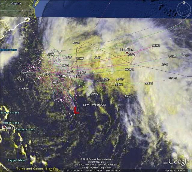
ronjon wrote:90L Model Plots:

That is all over the place...
0 likes
-
cycloneye
- Admin
- Posts: 149579
- Age: 69
- Joined: Thu Oct 10, 2002 10:54 am
- Location: San Juan, Puerto Rico
Re: ATL : INVEST 90L - COMPUTER MODELS
399
WHXX01 KWBC 240057
CHGHUR
TROPICAL CYCLONE GUIDANCE MESSAGE
NWS TPC/NATIONAL HURRICANE CENTER MIAMI FL
0057 UTC MON MAY 24 2010
DISCLAIMER...NUMERICAL MODELS ARE SUBJECT TO LARGE ERRORS.
PLEASE REFER TO NHC OFFICIAL FORECASTS FOR TROPICAL CYCLONE
AND SUBTROPICAL CYCLONE INFORMATION.
ATLANTIC OBJECTIVE AIDS FOR
DISTURBANCE INVEST (AL902010) 20100524 0000 UTC
...00 HRS... ...12 HRS... ...24 HRS. .. ...36 HRS...
100524 0000 100524 1200 100525 0000 100525 1200
LAT LON LAT LON LAT LON LAT LON
BAMS 26.2N 69.4W 26.8N 70.2W 27.7N 70.4W 28.7N 70.5W
BAMD 26.2N 69.4W 28.2N 69.5W 30.3N 70.2W 31.7N 71.7W
BAMM 26.2N 69.4W 27.3N 69.9W 28.8N 70.1W 30.1N 70.7W
LBAR 26.2N 69.4W 27.9N 69.3W 30.0N 69.3W 31.8N 69.7W
SHIP 35KTS 39KTS 42KTS 40KTS
DSHP 35KTS 39KTS 42KTS 40KTS
...48 HRS... ...72 HRS... ...96 HRS. .. ..120 HRS...
100526 0000 100527 0000 100528 0000 100529 0000
LAT LON LAT LON LAT LON LAT LON
BAMS 30.1N 70.6W 32.6N 69.7W 33.4N 65.8W 34.9N 54.4W
BAMD 32.6N 73.4W 32.5N 75.8W 30.7N 76.8W 30.4N 71.8W
BAMM 31.4N 71.6W 32.6N 72.8W 31.4N 73.7W 30.4N 72.0W
LBAR 33.2N 70.1W 33.7N 68.2W 32.2N 59.8W 34.2N 43.0W
SHIP 36KTS 36KTS 29KTS 18KTS
DSHP 36KTS 36KTS 29KTS 18KTS
...INITIAL CONDITIONS...
LATCUR = 26.2N LONCUR = 69.4W DIRCUR = 350DEG SPDCUR = 7KT
LATM12 = 24.8N LONM12 = 69.2W DIRM12 = 349DEG SPDM12 = 7KT
LATM24 = 23.3N LONM24 = 68.7W
WNDCUR = 35KT RMAXWD = 200NM WNDM12 = 30KT
CENPRS = 1006MB OUTPRS = 1010MB OUTRAD = 240NM SDEPTH = M
RD34NE = 200NM RD34SE = 0NM RD34SW = 0NM RD34NW = 0NM
0 likes
Visit the Caribbean-Central America Weather Thread where you can find at first post web cams,radars
and observations from Caribbean basin members Click Here
and observations from Caribbean basin members Click Here


Who is online
Users browsing this forum: No registered users and 40 guests