ATL : INVEST 92L - DISCUSSION

Moderator: S2k Moderators

Message
Author
User avatar
Gustywind
Category 5
Category 5
Posts: 12334
Joined: Mon Sep 03, 2007 7:29 am
Location: Baie-Mahault, GUADELOUPE

Re: ATL : INVEST 92L - DISCUSSION

#1061 Postby Gustywind » Fri Jun 18, 2010 5:12 am

HUC wrote:OOps...Correction for the barometer : that's 1012,5mb ( and not 1015 ) steady.i just awake!!!
i SHUT DOWN MY COMPUTER BECAUSE OF THUNDER

Oh thanks HUC for this precious info! Thunder is rumbling lighlty in my area without wind and rain... but weather is grey and sad. I will try to call you in case of as i have to work this morning...
Gustywind
0 likes   

User avatar
wxman57
Moderator-Pro Met
Moderator-Pro Met
Posts: 22977
Age: 67
Joined: Sat Jun 21, 2003 8:06 pm
Location: Houston, TX (southwest)

Re: ATL : INVEST 92L - DISCUSSION

#1062 Postby wxman57 » Fri Jun 18, 2010 5:32 am

For now, it remains a moderate tropical wave with a few heavy storms east of the wave axis. No reason to think it will develop over the next few days, as wind shear will remain high and then it'll be interacting with the larger islands of the northern Caribbean. Could be entering the SE Gulf near western Cuba by next Wednesday. That's when it has a shot at developing if there's anything left of the convection.
Last edited by wxman57 on Fri Jun 18, 2010 7:14 am, edited 1 time in total.
0 likes   

User avatar
cycloneye
Admin
Admin
Posts: 145279
Age: 68
Joined: Thu Oct 10, 2002 10:54 am
Location: San Juan, Puerto Rico

Re: ATL : INVEST 92L - DISCUSSION

#1063 Postby cycloneye » Fri Jun 18, 2010 5:44 am

Good morning. Puerto Rico is on a Flash Flood Watch from this afternoon thru Sunday.For more information from the islands,visit the Caribbean thread at U.S. & Caribbean forum.

viewtopic.php?f=24&t=85676&p=1992822#p1992822


AREA FORECAST DISCUSSION
NATIONAL WEATHER SERVICE SAN JUAN PR
535 AM AST FRI JUN 18 2010

.SYNOPSIS...AN ACTIVE TROPICAL WAVE AND ASSOCIATED WEAK SURFACE
LOW LOCATED JUST OVER THE LEEWARD ISLANDS EARLY THIS MORNING...
WILL MOVE WEST NORTHWEST ACROSS THE LOCAL AREA THROUGH THE
UPCOMING WEEKEND.

&&

.DISCUSSION...THE DOPPLER RADAR IS SHOWING ISOLATED TO SCATTERED
SHOWERS MOVING ACROSS THE EASTERN WATERS...MAINLY OVER WATERS
SOUTH OF VIEQUES. ISOLATED TO SCATTERED SHOWERS WILL CONTINUE TO
MOVE ON SHORE AND AFFECT THE NORTHEAST PORTIONS OF PUERTO RICO.

ALTHOUGH SUBSIDENCE ON FRONT OF THE TROPICAL WAVE WILL SLIGHTLY
LIMIT THE SHOWER DEVELOPMENT EARLIER TODAY...THE COMBINATION OF
LOCAL EFFECTS AND AVAILABLE MOISTURE WILL PRODUCE AFTERNOON SHOWERS
ACROSS THE INTERIOR AND SOUTHWEST PORTIONS OF PUERTO RICO.

THE LEADING EDGE OF THE TROPICAL WAVE WILL BEGIN TO AFFECT THE
U.S. VIRGIN ISLANDS THIS AFTERNOON. THESE SHOWERS ARE EXPECTED TO
MOVE WEST AND AFFECT PUERTO RICO THROUGH SATURDAY EVENING.
NOCTURNAL FLUCTUATIONS DUE TO THE DIURNAL MAXIMUM COULD INCREASE
THE SHOWER AND THUNDERSTORMS COVERAGE ACROSS THE LOCAL FORECAST
AREA THROUGH THE OVERNIGHT HOURS. MOISTURE ASSOCIATED TO THIS
TROPICAL WAVE WILL LINGER THROUGH SUNDAY AFTERNOON INCREASING THE
SHOWERS ACTIVITY ACROSS THE ISLANDS.

&&

.AVIATION...EXPECT PREVAILING VFR CONDITIONS ACROSS THE LOCAL
ISLANDS AND MOST LOCAL TAF SITES THIS MORNING. HOWEVER...MVFR
CONDITIONS...AND POSSIBLE IFR CONDITIONS ARE EXPECTED ACROSS
TNCM...AND TKPK FROM 18/10Z THROUGH AT LEAST 18/22Z.
MEANWHILE...PASSING SHOWERS ARE EXPECTED TO AFFECT TIST...AND TISX
DURING THE MORNING HOURS. FOR THIS AFTERNOON...MVFR CONDITIONS
WITH MOUNTAIN OBSCURATIONS ARE EXPECTED ACROSS TJMZ...AND TJPS IN
SHOWERS WITH ISOLATED THUNDERSTORMS.


&&

.MARINE...THE BEFORE MENTIONED TROPICAL WAVE WILL BRING ACTIVE
AND SQUALLY WEATHER WITH SHOWERS AND THUNDERSTORMS...LOCALLY HEAVY
RAINFALL...LOW VISIBILITIES...GUSTY WINDS AND CHOPPY SEAS CONDITIONS
TO THE REGIONAL WATERS. THEREFORE A SMALL CRAFT ADVISORY WILL BE
IN EFFECT FOR ALL OFFSHORE ATLANTIC AND CARIBBEAN WATERS. SMALL
CRAFT OPERATOR SHOULD EXERCISE CAUTION THROUGH TONIGHT.


&&

.PRELIMINARY POINT TEMPS/POPS...
SJU 88 79 89 79 / 30 80 70 60
STT 88 78 88 79 / 30 80 70 70
0 likes   
Visit the Caribbean-Central America Weather Thread where you can find at first post web cams,radars
and observations from Caribbean basin members Click Here

User avatar
Blown Away
S2K Supporter
S2K Supporter
Posts: 10145
Joined: Wed May 26, 2004 6:17 am

Re: ATL : INVEST 92L - DISCUSSION

#1064 Postby Blown Away » Fri Jun 18, 2010 6:34 am

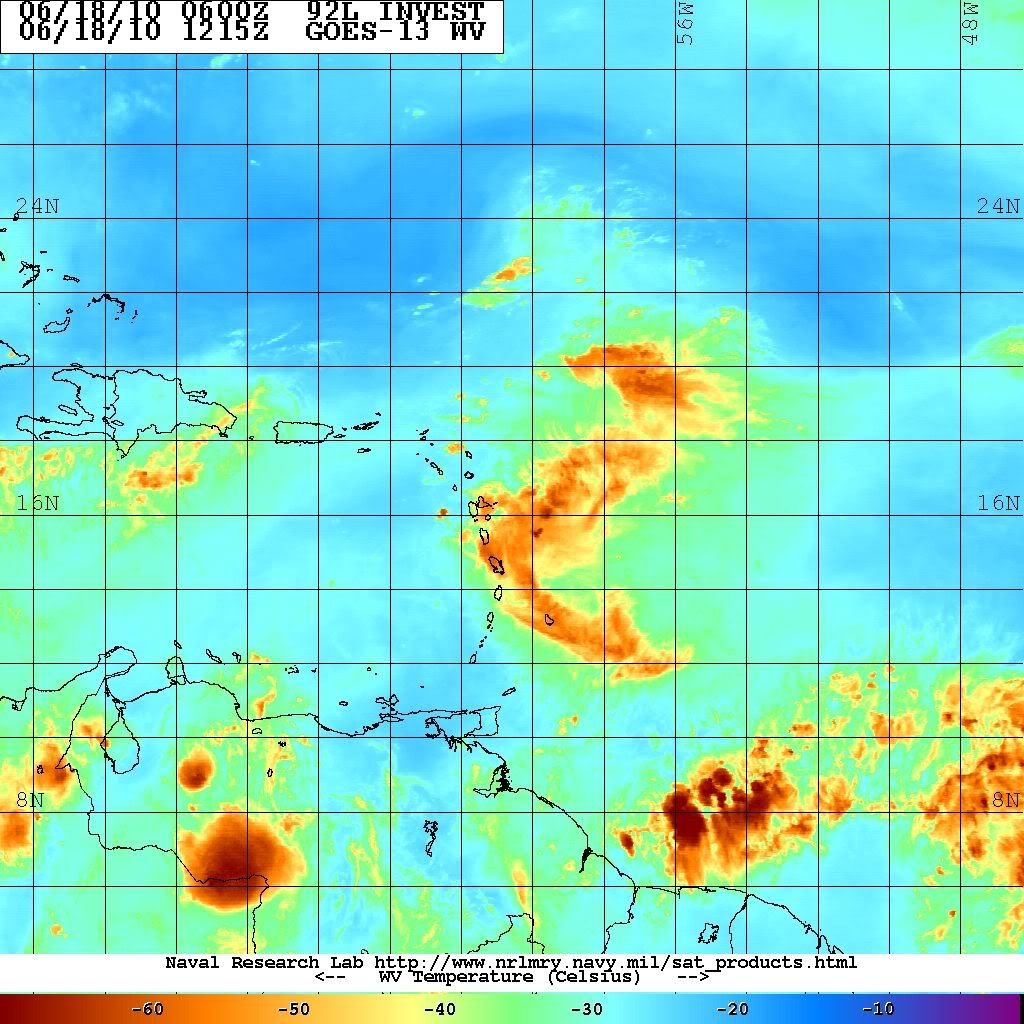
Big convection ball waning, but new convection building near the circulation center which is located near Guadeloupe. Where is Gustywind to give us a report?? :D
Anxious to see the visible this morning!
http://www.ssd.noaa.gov/goes/flt/t1/loop-rb.html
0 likes   
Hurricane Eye Experience: David 79, Irene 99, Frances 04, Jeanne 04, Wilma 05... EYE COMING MY WAY IN 2024…
Hurricane Brush Experience: Andrew 92, Erin 95, Floyd 99, Matthew 16, Irma 17, Ian 22, Nicole 22…

User avatar
cycloneye
Admin
Admin
Posts: 145279
Age: 68
Joined: Thu Oct 10, 2002 10:54 am
Location: San Juan, Puerto Rico

Re: ATL : INVEST 92L - DISCUSSION

#1065 Postby cycloneye » Fri Jun 18, 2010 6:39 am

Remains at 20%

TROPICAL WEATHER OUTLOOK
NWS TPC/NATIONAL HURRICANE CENTER MIAMI FL
800 AM EDT FRI JUN 18 2010

FOR THE NORTH ATLANTIC...CARIBBEAN SEA AND THE GULF OF MEXICO...

A STRONG TROPICAL WAVE MOVING OVER THE LESSER ANTILLES IS PRODUCING
A LARGE AREA OF SHOWERS AND THUNDERSTORMS. LOCALLY HEAVY RAINS AND
GUSTY WINDS ARE EXPECTED TO SPREAD OVER PORTIONS OF THE LEEWARD
ISLANDS...VIRGIN ISLANDS...AND PUERTO RICO OVER THE NEXT DAY OR TWO
AS THE SYSTEM MOVES WEST-NORTHWESTWARD AT 15 MPH. UPPER-LEVEL WINDS
ARE EXPECTED TO REMAIN UNFAVORABLE FOR DEVELOPMENT...AND THERE IS A
LOW CHANCE...20 PERCENT...OF THIS SYSTEM BECOMING A TROPICAL
CYCLONE DURING THE NEXT 48 HOURS.

ELSEWHERE...TROPICAL CYCLONE FORMATION IS NOT EXPECTED DURING THE
NEXT 48 HOURS.

$$
FORECASTER ROBERTS/BEVEN

0 likes   
Visit the Caribbean-Central America Weather Thread where you can find at first post web cams,radars
and observations from Caribbean basin members Click Here

User avatar
Blown Away
S2K Supporter
S2K Supporter
Posts: 10145
Joined: Wed May 26, 2004 6:17 am

Re: ATL : INVEST 92L - DISCUSSION

#1066 Postby Blown Away » Fri Jun 18, 2010 6:45 am

IMO, I think the shear has relaxed a bit and we will see new convection rebuild this morning as the area moves towards PR.
http://www.ssd.noaa.gov/goes/flt/t1/loop-rb.html
0 likes   
Hurricane Eye Experience: David 79, Irene 99, Frances 04, Jeanne 04, Wilma 05... EYE COMING MY WAY IN 2024…
Hurricane Brush Experience: Andrew 92, Erin 95, Floyd 99, Matthew 16, Irma 17, Ian 22, Nicole 22…

User avatar
Annie Oakley
Category 5
Category 5
Posts: 1103
Joined: Tue Jul 31, 2007 12:54 pm
Location: Texas

#1067 Postby Annie Oakley » Fri Jun 18, 2010 6:45 am

Gusty will be a major player this season I believe......like Hurakan.
0 likes   

User avatar
Annie Oakley
Category 5
Category 5
Posts: 1103
Joined: Tue Jul 31, 2007 12:54 pm
Location: Texas

#1068 Postby Annie Oakley » Fri Jun 18, 2010 6:47 am

AND CYCLONEYE
0 likes   

User avatar
cycloneye
Admin
Admin
Posts: 145279
Age: 68
Joined: Thu Oct 10, 2002 10:54 am
Location: San Juan, Puerto Rico

Re: ATL : INVEST 92L - DISCUSSION

#1069 Postby cycloneye » Fri Jun 18, 2010 6:49 am

It may not mean anything,but I found somewhat interesting the Dominica observations.

WSW and West Winds in Dominica
0 likes   
Visit the Caribbean-Central America Weather Thread where you can find at first post web cams,radars
and observations from Caribbean basin members Click Here

User avatar
KWT
Category 5
Category 5
Posts: 31415
Joined: Tue Aug 17, 2004 11:02 am
Location: UK!!!

#1070 Postby KWT » Fri Jun 18, 2010 6:51 am

Yeah that is pretty interesting cycloneye, would suggest there is probably some sort of lower level circulation present with this system afterall.
0 likes   
Personal Forecast Disclaimer:
The posts in this forum are NOT official forecast and should not be used as such. They are just the opinion of the poster and may or may not be backed by sound meteorological data. They are NOT endorsed by any professional institution or storm2k.org. For official information, please refer to the NHC and NWS products

xironman
S2K Supporter
S2K Supporter
Posts: 2522
Joined: Sun Jun 10, 2007 4:53 pm
Location: NoVA

Re: ATL : INVEST 92L - DISCUSSION

#1071 Postby xironman » Fri Jun 18, 2010 7:03 am

Since it is so disorganized and shallow do you think the BAMS with the more southern trajectory will be close?
0 likes   

User avatar
cycloneye
Admin
Admin
Posts: 145279
Age: 68
Joined: Thu Oct 10, 2002 10:54 am
Location: San Juan, Puerto Rico

Re: ATL : INVEST 92L - DISCUSSION

#1072 Postby cycloneye » Fri Jun 18, 2010 7:05 am

I dont see a well defined circulation,but maybe a very weak reflection west of Guadeloupe (The Butterfly Island)

Image
0 likes   
Visit the Caribbean-Central America Weather Thread where you can find at first post web cams,radars
and observations from Caribbean basin members Click Here

User avatar
KWT
Category 5
Category 5
Posts: 31415
Joined: Tue Aug 17, 2004 11:02 am
Location: UK!!!

#1073 Postby KWT » Fri Jun 18, 2010 7:10 am

Looks like convection is starting to fall apart again a little bit in the last few hours, certainly not as good as it was 6hrs ago.
0 likes   
Personal Forecast Disclaimer:
The posts in this forum are NOT official forecast and should not be used as such. They are just the opinion of the poster and may or may not be backed by sound meteorological data. They are NOT endorsed by any professional institution or storm2k.org. For official information, please refer to the NHC and NWS products

User avatar
tailgater
S2K Supporter
S2K Supporter
Posts: 3339
Joined: Sun Jul 11, 2004 9:13 pm
Location: St. Amant La.

Re: ATL : INVEST 92L - DISCUSSION

#1074 Postby tailgater » Fri Jun 18, 2010 7:41 am

Luis called it, the most vorticity just west of Guadeloupe.
Image
this is about as weak as it's been since it left Africa, I would have thought it would have thightened up a bit after last nite.
0 likes   
The following post is NOT an official forecast and should not be used as such. It is just the opinion of the poster and may or may not be backed by sound meteorological data. It is NOT endorsed by any professional institution including storm2k.org For Official Information please refer to the NHC and NWS products.

User avatar
srainhoutx
S2K Supporter
S2K Supporter
Posts: 6919
Age: 67
Joined: Sun Jan 14, 2007 11:34 am
Location: Haywood County, NC
Contact:

Re: ATL : INVEST 92L - DISCUSSION

#1075 Postby srainhoutx » Fri Jun 18, 2010 7:43 am

Certainly appears that 92L is nothing more than an open wave at this time. The big question is can it regain shear induced convection again.

Image
0 likes   
Carla/Alicia/Jerry(In The Eye)/Michelle/Charley/Ivan/Dennis/Katrina/Rita/Wilma/Ike/Harvey

Member: National Weather Association
Wx Infinity Forums
http://wxinfinity.com/index.php

Facebook.com/WeatherInfinity
Twitter @WeatherInfinity

clfenwi
Category 5
Category 5
Posts: 3331
Joined: Thu Jun 09, 2005 12:54 pm

Re: ATL : INVEST 92L - DISCUSSION

#1076 Postby clfenwi » Fri Jun 18, 2010 7:56 am

12Z best track

AL, 92, 2010061812, , BEST, 0, 161N, 622W, 25, 1011, WV, 0, , 0, 0, 0, 0,
0 likes   

User avatar
cycloneye
Admin
Admin
Posts: 145279
Age: 68
Joined: Thu Oct 10, 2002 10:54 am
Location: San Juan, Puerto Rico

Re: ATL : INVEST 92L - DISCUSSION

#1077 Postby cycloneye » Fri Jun 18, 2010 8:08 am

Here is the whole Best Track data for 92L that began on the 11th of June.

al922010.invest
0 likes   
Visit the Caribbean-Central America Weather Thread where you can find at first post web cams,radars
and observations from Caribbean basin members Click Here

User avatar
cycloneye
Admin
Admin
Posts: 145279
Age: 68
Joined: Thu Oct 10, 2002 10:54 am
Location: San Juan, Puerto Rico

Re: ATL : INVEST 92L - DISCUSSION

#1078 Postby cycloneye » Fri Jun 18, 2010 8:17 am

The most closest image you can find.

Image
0 likes   
Visit the Caribbean-Central America Weather Thread where you can find at first post web cams,radars
and observations from Caribbean basin members Click Here

User avatar
Fego
S2K Supporter
S2K Supporter
Posts: 767
Age: 65
Joined: Sun Apr 18, 2004 7:58 pm
Location: San Juan, Puerto Rico
Contact:

Re: ATL : INVEST 92L - DISCUSSION

#1079 Postby Fego » Fri Jun 18, 2010 8:36 am

Latest, latest at 9:15 am.
Image

Uploaded with ImageShack.us
0 likes   
Go Giants! Go Niners! Go Warriors!

User avatar
lrak
S2K Supporter
S2K Supporter
Posts: 1770
Age: 58
Joined: Thu Jun 21, 2007 2:48 pm
Location: Corpus Christi, TX

Re: ATL : INVEST 92L - DISCUSSION

#1080 Postby lrak » Fri Jun 18, 2010 8:44 am

It sure has grown since its inception.
0 likes   
AKA karl

Also
Personal Forecast Disclaimer:
My posts on this forum are NOT official forecast and should not be used as such. My posts are my basic observations and are definitely not backed by any "well some" meteorological knowledge. For official information, please refer to the NHC and NWS products.


Return to “2010”

Who is online

Users browsing this forum: No registered users and 3 guests