ATL: TROPICAL DEPRESSION BONNIE - DISCUSSION

Moderator: S2k Moderators

Message
Author
Aric Dunn
Category 5
Category 5
Posts: 21238
Age: 42
Joined: Sun Sep 19, 2004 9:58 pm
Location: Ready for the Chase.
Contact:

Re: ATL: TROPICAL DEPRESSION THREE - DISCUSSION

#1761 Postby Aric Dunn » Thu Jul 22, 2010 11:33 am

very interesting.. latest shear tendency... shear is dropping fast and basically is not there at least in the upper levels. looks like some mid level shear atm

Image

its under 10 kt
Image
Last edited by Aric Dunn on Thu Jul 22, 2010 11:34 am, edited 1 time in total.
0 likes   

User avatar
funster
Category 3
Category 3
Posts: 817
Joined: Sat Dec 29, 2007 4:27 pm
Location: North Dallas

#1762 Postby funster » Thu Jul 22, 2010 11:33 am

It was born an exposed TD. We have seen storms that have been sheared and still manage to become a strong TS. The warm temps will help TD3 stay alive and generate convection despite the shear to a degree.
0 likes   

Stormcenter
S2K Supporter
S2K Supporter
Posts: 6684
Joined: Wed Sep 03, 2003 11:27 am
Location: Houston, TX

Re:

#1763 Postby Stormcenter » Thu Jul 22, 2010 11:34 am

For some reason I'm still thinking the AL/FL. stateline.


rockyman wrote:Keep in mind that final landfall is almost within the THREE day cone, so I wouldn't expect drastic shifts in the forecast track.
0 likes   

User avatar
TreasureIslandFLGal
S2K Supporter
S2K Supporter
Posts: 1581
Age: 57
Joined: Sun Aug 15, 2004 6:16 pm
Location: Clearwater, Florida ~3 miles from the coast now. We finally moved safely off the barrier island!

Re: ATL: TROPICAL DEPRESSION THREE - DISCUSSION

#1764 Postby TreasureIslandFLGal » Thu Jul 22, 2010 11:34 am

I don't foresee any real drastic shift. I think 2nd landfall will be at the far right of the cone, in fact, just a few miles beyond where it sits now.
0 likes   
Chrissy & Ligeia
:flag:

User avatar
Steve
S2K Supporter
S2K Supporter
Posts: 9621
Joined: Sat Apr 05, 2003 11:41 pm
Location: Not a state-caster

Re: ATL: TROPICAL DEPRESSION THREE - DISCUSSION

#1765 Postby Steve » Thu Jul 22, 2010 11:35 am

Stormcenter,

I was actually semi-agreeing with you. There should be some influence for a while which will keep things more in check than unhinged. However, if you read the experts (pro mets, Aric, etc.) you will see that the upper level environment is already getting better as the patter is reversing. As wxman57 said yesterday, you never know with upper features - how they are going to react, how strong they are going to be, where they're going to split, how much will this impact the surrounding environment, etc. So while I feel like there will be some influence from the concentric upper low diving through the retreating TUTT, it's going to be less and less over time. It's already starting. As Air Force Met says a few posts up, "Indeed, shear is lessening by the moment."
0 likes   

Frank2
Category 5
Category 5
Posts: 4061
Joined: Mon Jul 25, 2005 12:47 pm

Re: ATL: TROPICAL DEPRESSION THREE - DISCUSSION

#1766 Postby Frank2 » Thu Jul 22, 2010 11:36 am

The LLC appears to be broad and not well defined as it rolls along, and is moving fast enough that it likely will be SSE of Miami by 00Z:

http://www.ssd.noaa.gov/goes/flt/t1/flash-vis.html
Last edited by Frank2 on Thu Jul 22, 2010 11:38 am, edited 1 time in total.
0 likes   

tolakram
Admin
Admin
Posts: 20012
Age: 62
Joined: Sun Aug 27, 2006 8:23 pm
Location: Florence, KY (name is Mark)

Re: ATL: TROPICAL DEPRESSION THREE - DISCUSSION

#1767 Postby tolakram » Thu Jul 22, 2010 11:37 am

tailgater wrote:Looks like it's gonna be an exposed TD soon.Still pretty dry near the center. Just some high clouds over the top right now.
http://weather.msfc.nasa.gov/GOES/GOES1 ... 7Ig54B.jpg


Might want to look at the progression rather than a still image.

http://wwwghcc.msfc.nasa.gov/cgi-bin/ge ... umframes=5

N/NE wall of convection continues to build. I think dry air is more of a problem right now than shear.
Last edited by tolakram on Thu Jul 22, 2010 11:38 am, edited 1 time in total.
0 likes   
M a r k
- - - - -
Join us in chat: Storm2K Chatroom Invite. Android and IOS apps also available.

The posts in this forum are NOT official forecasts and should not be used as such. Posts are NOT endorsed by any professional institution or STORM2K.org. For official information and forecasts, please refer to NHC and NWS products.

User avatar
TreasureIslandFLGal
S2K Supporter
S2K Supporter
Posts: 1581
Age: 57
Joined: Sun Aug 15, 2004 6:16 pm
Location: Clearwater, Florida ~3 miles from the coast now. We finally moved safely off the barrier island!

Re: ATL: TROPICAL DEPRESSION THREE - DISCUSSION

#1768 Postby TreasureIslandFLGal » Thu Jul 22, 2010 11:38 am

If the ULL keeps on trucking and this storm generally goes along with it, the pocket of minimal shear that she is in right now could travel right along with soon to be Bonnie for quite a while, enabling intensification before the ULL breaks away from such heavy influence.
0 likes   
Chrissy & Ligeia
:flag:

Frank2
Category 5
Category 5
Posts: 4061
Joined: Mon Jul 25, 2005 12:47 pm

#1769 Postby Frank2 » Thu Jul 22, 2010 11:41 am

There's a TUTT feature dropping SW underneath the high (and behind the ULL) - not sure if that'll have an effect on TD3:

http://www.goes.noaa.gov/HURRLOOPS/huwvloop.html
Last edited by Frank2 on Thu Jul 22, 2010 11:42 am, edited 1 time in total.
0 likes   

User avatar
eastcoastFL
Category 5
Category 5
Posts: 3901
Age: 43
Joined: Thu Apr 12, 2007 12:29 pm
Location: Palm City, FL

Re: ATL: TROPICAL DEPRESSION THREE - DISCUSSION

#1770 Postby eastcoastFL » Thu Jul 22, 2010 11:41 am

Should we see some action here in palm beach county? its so beautiful out today
0 likes   
Personal Forecast Disclaimer:
The posts in this forum are NOT official forecast and should not be used as such. They are just the opinion of the poster and may or may not be backed by sound meteorological data. They are NOT endorsed by any professional institution or storm2k.org. For official information, please refer to the NHC and NWS products.

Frank2
Category 5
Category 5
Posts: 4061
Joined: Mon Jul 25, 2005 12:47 pm

Re: ATL: TROPICAL DEPRESSION THREE - DISCUSSION

#1771 Postby Frank2 » Thu Jul 22, 2010 11:44 am

...but that TUTT-like feature is definitely starting to surpress (squeeze) any outflow from TD-3's convection (we'll see if that's mentioned in the TCD)...

http://www.goes.noaa.gov/HURRLOOPS/huwvloop.html
Last edited by Frank2 on Thu Jul 22, 2010 11:46 am, edited 3 times in total.
0 likes   

User avatar
tailgater
S2K Supporter
S2K Supporter
Posts: 3339
Joined: Sun Jul 11, 2004 9:13 pm
Location: St. Amant La.

Re: ATL: TROPICAL DEPRESSION THREE - DISCUSSION

#1772 Postby tailgater » Thu Jul 22, 2010 11:45 am

tolakram wrote:
tailgater wrote:Looks like it's gonna be an exposed TD soon.Still pretty dry near the center. Just some high clouds over the top right now.
http://weather.msfc.nasa.gov/GOES/GOES1 ... 7Ig54B.jpg


Might want to look at the progression rather than a still image.

http://wwwghcc.msfc.nasa.gov/cgi-bin/ge ... umframes=5

N/NE wall of convection continues to build. I think dry air is more of a problem right now than shear.

I have been watching the Vis loop and now the IR loop and it looks like the canopy that was over the top has now moved to mostly over the northern half.
0 likes   
The following post is NOT an official forecast and should not be used as such. It is just the opinion of the poster and may or may not be backed by sound meteorological data. It is NOT endorsed by any professional institution including storm2k.org For Official Information please refer to the NHC and NWS products.

User avatar
Extremeweatherguy
Category 5
Category 5
Posts: 11095
Joined: Mon Oct 10, 2005 8:13 pm
Location: Florida

Re: ATL: TROPICAL DEPRESSION THREE - DISCUSSION

#1773 Postby Extremeweatherguy » Thu Jul 22, 2010 11:46 am

One thing is for sure, even if this goes along its current path through the keys, a large chunk of Florida could still be impacted by TD#3/Bonnie's outer rain bands. I made an image of the approximate NHC path (red line) and then outlined where the storm's convection would travel if the structure remained fairly similar throughout TD #3/Bonnie's life cycle, and this is the result:

Image

The system is currently lopsided toward the right, and as long as some southerly shear remains and/or it stays weak, that is probably how it will stay. This would put the storm's heaviest convection (orange zone) into the southern 1/2 of the state of Florida, and would even allow isolated outer bands (yellow zone) to possibly be seen as far north as the northern parts of the peninsula. This means that while the "center" may be in the keys, Miami, Naples, Palm Beach and even up to central Florida to a lesser degree could all get in on decent bands of rain and squally weather as the system passes by. An isolated outer band or two might even wander up towards Ocala, Gainesville, Daytona Beach and perhaps Jacksonville if the storm structure remained similar. Once in the Gulf, this orientation of the storm (right lop side) would also potentially spell trouble for the oil spill region and could lead to nasty weather (wet, windy, higher waves) across LA/MS as the storm moved by to the south. However, being that that part of the forecast is still days away, I wouldn't put too much stock on this image past the near term (Florida impact). There is still plenty of time to watch the storm structure evolve before worrying about specific impacts that far west just yet.

Personal Forecast Disclaimer:
The posts in this forum are NOT official forecast and should not be used as such. They are just the opinion of the poster and may or may not be backed by sound meteorological data. They are NOT endorsed by any professional institution or storm2k.org. For official information, please refer to the NHC and NWS products.
0 likes   

Air Force Met
Military Met
Military Met
Posts: 4372
Age: 56
Joined: Tue Jul 08, 2003 9:30 am
Location: Roan Mountain, TN

Re: Re:

#1774 Postby Air Force Met » Thu Jul 22, 2010 11:49 am

Stormcenter wrote:For some reason I'm still thinking the AL/FL. stateline.


rockyman wrote:Keep in mind that final landfall is almost within the THREE day cone, so I wouldn't expect drastic shifts in the forecast track.


WAY too far east...IMO. I am thinking more towards the TX/LA state line. A lot will depend on the shear and if the center tries to nudge N'ward towards convection during the next day or two...but that ridge is MASSIVE...and it isn't going anywhere anytime soon.

Image
0 likes   

User avatar
fci
S2K Supporter
S2K Supporter
Posts: 3324
Joined: Tue Sep 14, 2004 10:29 am
Location: Lake Worth, FL

#1775 Postby fci » Thu Jul 22, 2010 11:49 am

So, I will rain a bit on the excitement of TD3.
With a TD or weak TS there really is no "landfall".
It is a pretty broad area of circulation, not well organized or intense so no one gets "hit".
Actually, the difference between a strong Tropical Wave (yesterday) and a Tropical Depression (today) is just a bit of organization, not much difference in "intensity".

South Florida really should not be deemed as "in the crosshairs". (which I have read in the prior pages of this thread)
Crosshairs of what?
A disorganized blog of clouds and showers!

"Be safe in The Keys", is a considerate thing to say; however there will be little impact there beyond a bit of a rainy, windy day. No big whoop!
Weatherwise, South Florida will get some more cloudiness, a little more wind (the past few days the winds have been gusty anyway) not really a discernible change; and more rain. Not continual torrential downpours but more frequent spells of rain.

All in all, getting "hit" by a TD or weak TS in no different than an extended period of typical summertime convection, just a little more concentrated.

Sorry to take the thrill away from some of you, but having a TD or weak TS pass by is not a big deal except in very rare circumstances..(it stalls and causes flooding, etc.. which this system shows no sign of doing)
0 likes   

jhpigott
Category 2
Category 2
Posts: 570
Joined: Wed Jan 02, 2008 8:09 pm
Location: North Palm Beach, Florida

Re: ATL: TROPICAL DEPRESSION THREE - DISCUSSION

#1776 Postby jhpigott » Thu Jul 22, 2010 11:50 am

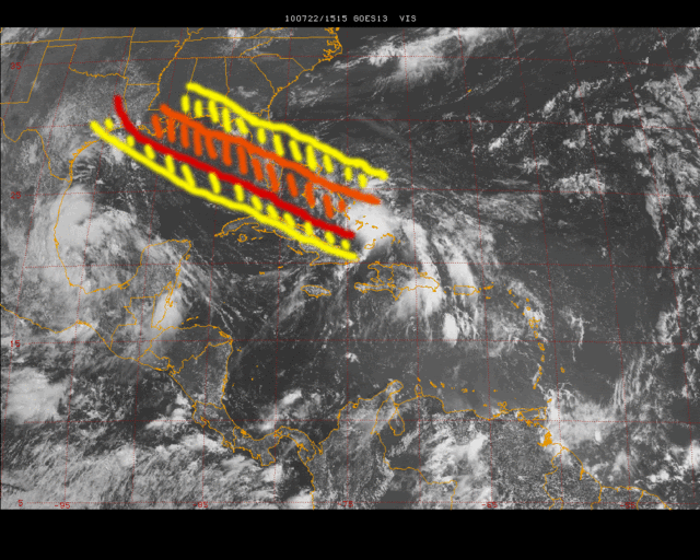
Extremeweatherguy wrote:One thing is for sure, even if this goes along its current path through the keys, a large chunk of Florida could still be impacted by TD#3/Bonnie's outer rain bands. I made an image of the approximate NHC path (red line) and then outlined where the storm's convection would travel if the structure remained fairly similar throughout TD #3/Bonnie's life cycle, and this is the result:

The system is currently lopsided toward the right, and as long as some southerly shear remains and/or it stays weak, that is probably how it will stay. This would put the storm's heaviest convection (orange zone) into the southern 1/2 of the state of Florida, and would even allow isolated outer bands (yellow zone) to possibly be seen as far north as the northern parts of the peninsula. This means that while the "center" may be in the keys, Miami, Naples, Palm Beach and even up to central Florida to a lesser degree could all get in on decent bands of rain and squally weather as the system passes by. An isolated outer band or two might even wander up towards Ocala, Gainesville, Daytona Beach and perhaps Jacksonville if the storm structure remained similar. Once in the Gulf, this orientation of the storm (right lop side) would also potentially spell trouble for the oil spill region and could lead to nasty weather (wet, windy, higher waves) across LA/MS as the storm moved by to the south. However, being that that part of the forecast is still days away, I wouldn't put too much stock on this image past the near term (Florida impact). There is still plenty of time to watch the storm structure evolve before worrying about impacts that far west just yet.

Personal Forecast Disclaimer:
The posts in this forum are NOT official forecast and should not be used as such. They are just the opinion of the poster and may or may not be backed by sound meteorological data. They are NOT endorsed by any professional institution or storm2k.org. For official information, please refer to the NHC and NWS products.


That's a good enough reason for all of us in the southern half of Florida to expect some squally weather. As long as we have S-SWesterly shear, the bad weather is going to be north of the center.
0 likes   

Frank2
Category 5
Category 5
Posts: 4061
Joined: Mon Jul 25, 2005 12:47 pm

Re: ATL: TROPICAL DEPRESSION THREE - DISCUSSION

#1777 Postby Frank2 » Thu Jul 22, 2010 11:50 am

I'd have to disagree with extremeweatherguy - per the local NWS forecast (Miami) most of the rainfall will be in the Keys, with decreasing amounts up the Florida east coast - SW Florida might see more than we will here in Fort Lauderdale, but that remains to be seen...

This is from the Miami NWSFO (updated less than 1 hour ago):

NEWLY FORMED TROPICAL DEPRESSION #3 OVER THE SOUTHEAST BAHAMA
ISLANDS IS FORECAST BY THE NATIONAL HURRICANE CENTER TO MOVE TO
THE WEST NORTHWEST THROUGH THE FLORIDA KEYS ON FRIDAY AND INTO THE
SOUTHERN GULF OF MEXICO FRIDAY NIGHT. MOST OF THE WEATHER RELATED
TO THE NEWLY FORMED TROPICAL DEPRESSION #3 SHOULD AFFECT SOUTH
FLORIDA LATE TONIGHT INTO FRIDAY.
0 likes   

User avatar
Macrocane
Category 5
Category 5
Posts: 4218
Age: 36
Joined: Sun May 24, 2009 5:35 pm
Location: El Salvador

Re: ATL: TROPICAL DEPRESSION THREE - DISCUSSION

#1778 Postby Macrocane » Thu Jul 22, 2010 11:53 am

The cloud tops are warming a bit but it has some good inflow channels maybe it's just a question of time for convection to intensify again.
0 likes   

MWatkins
S2K Supporter
S2K Supporter
Posts: 2574
Joined: Sat Oct 12, 2002 7:51 pm
Location: SE Florida
Contact:

Re: ATL: TROPICAL DEPRESSION THREE - DISCUSSION

#1779 Postby MWatkins » Thu Jul 22, 2010 11:54 am

One quick note (other than the poor initilization of the 12Z NOGAPS, it starts with TD3 sitting on the north coast of Cuba, hard to imagine why)...

Note the band extending to the SW...that's a pretty good indicator that the structure of the cyclone is improving.

Again, and I have been saying this all week, it's hard to tell if this is a "good" upper low or a bad one.

Up until now it's been both, it created difluence aloft and allowed the wave to generate convection for a couple of days, but it has also hindered development.

Now that it is getting out of the way, the interaction is going to be tricky, and I don't think the models have the resolution to handle the interaction between the two features perfectly at the very local scale.

Remember, we know almost nothing about intensity.

MW
0 likes   
Updating on the twitter now: http://www.twitter.com/@watkinstrack

StormClouds63
Category 2
Category 2
Posts: 583
Age: 62
Joined: Tue May 13, 2008 11:56 am
Location: Southwest Louisiana

Re: ATL: TROPICAL DEPRESSION THREE - DISCUSSION

#1780 Postby StormClouds63 » Thu Jul 22, 2010 11:57 am

So far, there's nothing about this system and the overall weather pattern that makes you think this is going to be anything more than a weak to moderate TS. Shear from the south and southwest continues. The ULL is still not moving fast enough west not to continue to influence TD 3. I think the NHC's intensity forecasts are right on the money, unless some major changes take place. I'm still hoping this turns out like Chris in 2006.
0 likes   


Return to “2010”

Who is online

Users browsing this forum: No registered users and 5 guests