ATL : INVEST 90L

Moderator: S2k Moderators

Message
Author
cwachal

Re:

#181 Postby cwachal » Mon May 24, 2010 6:27 am

KWT wrote:I believe the C actually stands for current, so the model is expecting to slowly loose warm core properties, which makes sense given the upper low weeakens and SST's cool down.


well it shows it getting slightly more warmed core just over the next 12 hours and then heading toward cold core
0 likes   

cwachal

Re: ATL : INVEST 90L=CODE ORANGE

#182 Postby cwachal » Mon May 24, 2010 6:27 am

Hurricane Andrew wrote:
wxman57 wrote:I suggest you don't get too carried away with your enthusiasm for seeing this named too soon. I'm looking at a plot of surface obs with a satellite overlay that says we have only a very broad circulation about 600 miles across with the main center well to the SW of any convection. It has a long way to go to become Alex. Winds around the low are generally in the 20-25 kt range. If the convection does centralize, though, the center should tighten over the next day or two. Could see STS Alex out of this, but not within 24 hrs most likely. If the NHC thought otherwise, they wouldn't be saying only a 30% chance of development over the next 48 hrs.

Yeah...The low under the convection really needs to tighten up some.

Question-are subtropical storms warm core or cold core(i need to know)?


"Yes"
0 likes   

User avatar
Janie2006
Category 5
Category 5
Posts: 1328
Joined: Mon Sep 18, 2006 3:28 pm
Location: coastal Ms aka home of the hurricanes

Re: ATL : INVEST 90L=CODE ORANGE

#183 Postby Janie2006 » Mon May 24, 2010 6:43 am

Certainly an interesting feature and perhaps a precursor of what's to come, but I think it's going to face a good struggle in reaching even STS status at this point in time.
0 likes   

User avatar
HURAKAN
Professional-Met
Professional-Met
Posts: 46086
Age: 38
Joined: Thu May 20, 2004 4:34 pm
Location: Key West, FL
Contact:

#184 Postby HURAKAN » Mon May 24, 2010 7:08 am

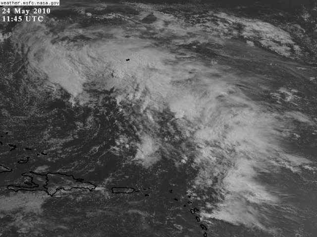
Image

Immense system
0 likes   

User avatar
cycloneye
Admin
Admin
Posts: 143871
Age: 68
Joined: Thu Oct 10, 2002 10:54 am
Location: San Juan, Puerto Rico

Re: ATL : INVEST 90L=CODE ORANGE

#185 Postby cycloneye » Mon May 24, 2010 7:49 am

12 UTC Best Track

AL, 90, 2010052412, , BEST, 0, 270N, 700W, 35, 1005, LO
0 likes   
Visit the Caribbean-Central America Weather Thread where you can find at first post web cams,radars
and observations from Caribbean basin members Click Here

User avatar
HURAKAN
Professional-Met
Professional-Met
Posts: 46086
Age: 38
Joined: Thu May 20, 2004 4:34 pm
Location: Key West, FL
Contact:

#186 Postby HURAKAN » Mon May 24, 2010 8:09 am

Image

Loop
0 likes   

cwachal

#187 Postby cwachal » Mon May 24, 2010 8:41 am

Looks like some convection over the center
0 likes   

User avatar
Pedro Fernández
Tropical Storm
Tropical Storm
Posts: 233
Age: 47
Joined: Mon Dec 31, 2007 7:24 am
Location: Costa Tropical (Granada, Spain).
Contact:

#188 Postby Pedro Fernández » Mon May 24, 2010 8:51 am

I see this system quite worse than yesterday... Since w-shear has rised up to 30 KT over the system, and SAL and dry ir are playing on it.

Cyclone Phase diagrams from GFS don't anticipate deepening, as they pointed yesterday.

Now, I don't see too much opportunities for the 90L.
0 likes   

cwachal

#189 Postby cwachal » Mon May 24, 2010 8:56 am

this storm looks to be trying and cut off that dry air that has been giving the storm a hard time all along
0 likes   

User avatar
cycloneye
Admin
Admin
Posts: 143871
Age: 68
Joined: Thu Oct 10, 2002 10:54 am
Location: San Juan, Puerto Rico

Re: ATL : INVEST 90L=CODE ORANGE

#190 Postby cycloneye » Mon May 24, 2010 9:06 am

SPECIAL TROPICAL WEATHER OUTLOOK
NWS TPC/NATIONAL HURRICANE CENTER MIAMI FL
955 AM EDT MON MAY 24 2010

FOR THE NORTH ATLANTIC...CARIBBEAN SEA AND THE GULF OF MEXICO...

SATELLITE IMAGES AND SURFACE OBSERVATIONS INDICATE THAT THE
NON-TROPICAL LOW PRESSURE SYSTEM CENTERED ABOUT 475 MILES SOUTHWEST
OF BERMUDA HAS NOT BECOME BETTER ORGANIZED SINCE YESTERDAY. THIS
SYSTEM IS PRODUCING A LARGE AREA OF DISORGANIZED SHOWERS AND
THUNDERSTORMS OVER THE SOUTHWESTERN ATLANTIC OCEAN ALONG WITH WINDS
TO GALE FORCE. THE LOW IS EXPECTED TO MOVE SLOWLY TOWARD THE
NORTH-NORTHWEST AND IT STILL HAS THE POTENTIAL TO ACQUIRE
SUBTROPICAL CHARACTERISTICS DURING THE NEXT DAY OR SO. THERE IS A
MEDIUM CHANCE...30 PERCENT... OF THIS SYSTEM BECOMING A SUBTROPICAL
CYCLONE DURING THE NEXT 48 HOURS. FOR ADDITIONAL INFORMATION...
PLEASE SEE HIGH SEAS FORECASTS ISSUED BY THE NATIONAL WEATHER
SERVICE...UNDER AWIPS HEADER NFDHSFAT1 AND WMO HEADER FZNT01 KWBC.
ANOTHER STATEMENT WILL BE ISSUED BY THE NATIONAL HURRICANE CENTER
THIS EVENING.

$$
FORECASTER PASCH/ROBERTS

Image
0 likes   
Visit the Caribbean-Central America Weather Thread where you can find at first post web cams,radars
and observations from Caribbean basin members Click Here

cwachal

Re: ATL : INVEST 90L=CODE ORANGE

#191 Postby cwachal » Mon May 24, 2010 9:34 am

Image

if you watch the loop and look at that area you will see the center of circulation and storms developing right over the center
0 likes   

tolakram
Admin
Admin
Posts: 19990
Age: 61
Joined: Sun Aug 27, 2006 8:23 pm
Location: Florence, KY (name is Mark)

Re: ATL : INVEST 90L=CODE ORANGE

#192 Postby tolakram » Mon May 24, 2010 9:42 am

0 likes   
M a r k
- - - - -
Join us in chat: Storm2K Chatroom Invite. Android and IOS apps also available.

The posts in this forum are NOT official forecasts and should not be used as such. Posts are NOT endorsed by any professional institution or STORM2K.org. For official information and forecasts, please refer to NHC and NWS products.

capepoint
Category 1
Category 1
Posts: 415
Joined: Sat Jul 19, 2008 7:13 pm
Location: Beaufort, NC

#193 Postby capepoint » Mon May 24, 2010 9:44 am

good morning from the southern outer banks of North Carolina.
Sky almost looks tropical this morning. Dark offshore, with showers moving inland. Very light breezes, ocean not too rough.
All in all, not too bad. We like this weather, it keeps the tourists home. lol.

Not expecting much from this, maybe an increased rip current threat, and some showers, but we need the rain, so let it come.
I'm going fishing out on Cape Lookout Shoals in about an hour. I have a 23 foot boat, so that tells you how bad the conditions are.
0 likes   

cwachal

#194 Postby cwachal » Mon May 24, 2010 9:49 am

Image

Look at the area of dropping wind shear almost all of the MDR and the region over where 90L is
0 likes   

User avatar
Category 5
Category 5
Category 5
Posts: 10074
Age: 35
Joined: Sun Feb 11, 2007 10:00 pm
Location: New Brunswick, NJ
Contact:

Re: ATL : INVEST 90L=CODE ORANGE

#195 Postby Category 5 » Mon May 24, 2010 9:51 am

If this is gonna make a move its gonna have to do it fast IMO.
0 likes   

cwachal

#196 Postby cwachal » Mon May 24, 2010 9:55 am

Image

Vorticity has increased over the area I pointed out earlier
0 likes   

User avatar
Lowpressure
S2K Supporter
S2K Supporter
Posts: 2032
Age: 58
Joined: Sun Sep 14, 2003 9:17 am
Location: Charlotte, North Carolina

Re: ATL : INVEST 90L=CODE ORANGE

#197 Postby Lowpressure » Mon May 24, 2010 9:56 am

Interesting to watch the interaction with the other low near the OBX.
0 likes   

User avatar
Category 5
Category 5
Category 5
Posts: 10074
Age: 35
Joined: Sun Feb 11, 2007 10:00 pm
Location: New Brunswick, NJ
Contact:

Re: ATL : INVEST 90L=CODE ORANGE

#198 Postby Category 5 » Mon May 24, 2010 10:27 am

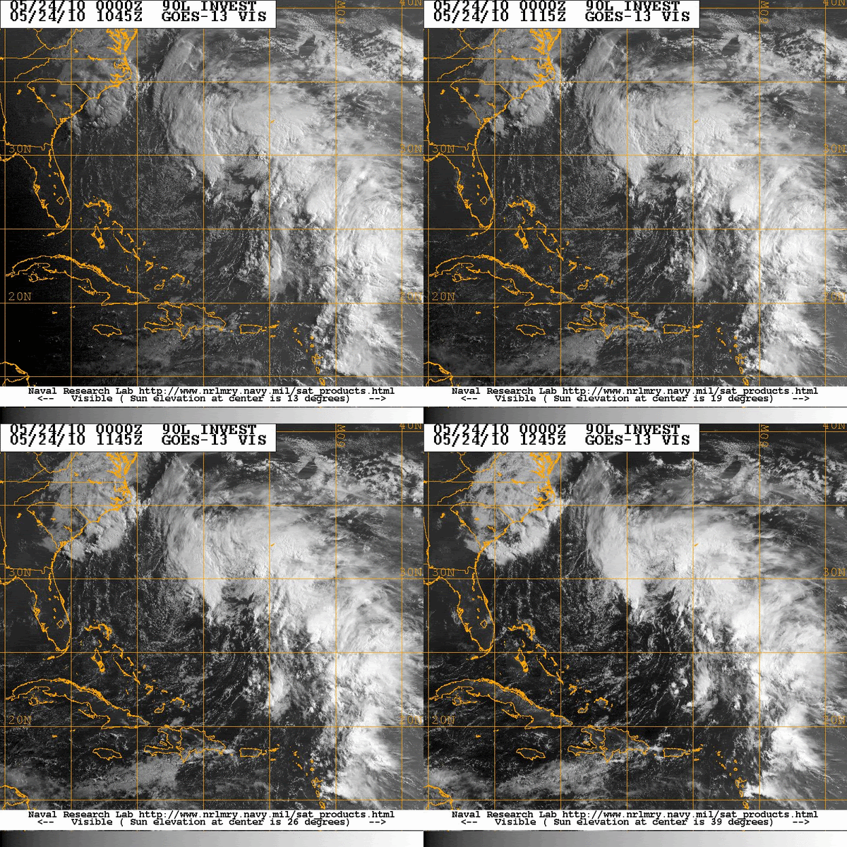
Umm, am I crazy, or do I see multiple spinups on the visible?
0 likes   

cwachal

#199 Postby cwachal » Mon May 24, 2010 11:10 am

Image
0 likes   

User avatar
HURAKAN
Professional-Met
Professional-Met
Posts: 46086
Age: 38
Joined: Thu May 20, 2004 4:34 pm
Location: Key West, FL
Contact:

#200 Postby HURAKAN » Mon May 24, 2010 11:22 am

Image

Latest
0 likes   


Return to “2010”

Who is online

Users browsing this forum: No registered users and 64 guests