ATL : TROPICAL DEPRESSION ALEX - MODELS

Moderator: S2k Moderators

Message
Author
Brent
S2K Supporter
S2K Supporter
Posts: 38088
Age: 36
Joined: Sun May 16, 2004 10:30 pm
Location: Tulsa Oklahoma
Contact:

Re: ATL : INVEST 93L - MODELS

#181 Postby Brent » Tue Jun 22, 2010 1:57 am

Ivanhater wrote:
ROCK wrote:what I dont get is it does this weird little jog around Cuba very odd.....


Yeah, it's combining tonights run and last nights. That is why you see it jump


That's why it doesn't make sense.
0 likes   
#neversummer

User avatar
Ivanhater
Storm2k Moderator
Storm2k Moderator
Posts: 11160
Age: 38
Joined: Fri Jul 01, 2005 8:25 am
Location: Pensacola

Re: ATL : INVEST 93L - MODELS

#182 Postby Ivanhater » Tue Jun 22, 2010 1:57 am

Nothing crazy on tonight's run

Image
0 likes   
Michael

Wx_Warrior
Category 5
Category 5
Posts: 2718
Joined: Thu Aug 03, 2006 3:58 pm
Location: Beaumont, TX

Re: ATL : INVEST 93L - MODELS

#183 Postby Wx_Warrior » Tue Jun 22, 2010 1:59 am

There you go Ivan...that other you can delete off your favs...LOL
0 likes   

User avatar
ROCK
Category 5
Category 5
Posts: 9484
Age: 54
Joined: Tue Aug 17, 2004 7:30 am
Location: Kemah, Texas

Re: ATL : INVEST 93L - MODELS

#184 Postby ROCK » Tue Jun 22, 2010 1:59 am

Man that is what I get for following a Eastern member's model page....how jacked it that when the 0hr say 6/22 0Z but yet it doesnt update the entire loop....huh...
0 likes   

User avatar
HouTXmetro
Category 5
Category 5
Posts: 3949
Joined: Sun Jun 13, 2004 6:00 pm
Location: District of Columbia, USA

Re: ATL : INVEST 93L - MODELS

#185 Postby HouTXmetro » Tue Jun 22, 2010 2:00 am

I don't see much on the Euro, is that a weak system headed into Texas?
0 likes   
[Disclaimer: My Amateur Opinion, please defer to your local authorities or the NHC for Guidance.]

Brent
S2K Supporter
S2K Supporter
Posts: 38088
Age: 36
Joined: Sun May 16, 2004 10:30 pm
Location: Tulsa Oklahoma
Contact:

Re: ATL : INVEST 93L - MODELS

#186 Postby Brent » Tue Jun 22, 2010 2:00 am

Ivanhater wrote:Nothing crazy on tonight's run
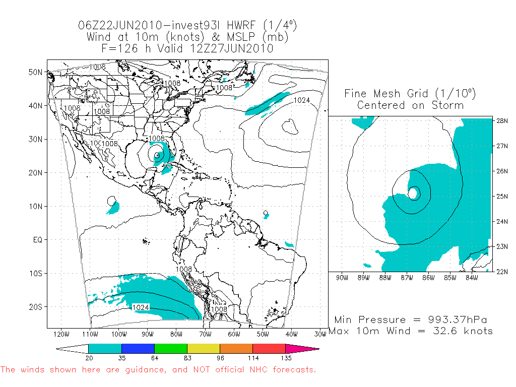
Image


That was... not interesting. :lol:
0 likes   
#neversummer

Wx_Warrior
Category 5
Category 5
Posts: 2718
Joined: Thu Aug 03, 2006 3:58 pm
Location: Beaumont, TX

Re: ATL : INVEST 93L - MODELS

#187 Postby Wx_Warrior » Tue Jun 22, 2010 2:01 am

Heavy rainmaker there....way too early for "it's going here, hide the chickens and hens..."
0 likes   

User avatar
ROCK
Category 5
Category 5
Posts: 9484
Age: 54
Joined: Tue Aug 17, 2004 7:30 am
Location: Kemah, Texas

Re: ATL : INVEST 93L - MODELS

#188 Postby ROCK » Tue Jun 22, 2010 2:01 am

the Euro web site updated faster than Allan's.....nice...and here I thought I was special...

the last run is similar to 12z also...
0 likes   

User avatar
Ivanhater
Storm2k Moderator
Storm2k Moderator
Posts: 11160
Age: 38
Joined: Fri Jul 01, 2005 8:25 am
Location: Pensacola

Re: ATL : INVEST 93L - MODELS

#189 Postby Ivanhater » Tue Jun 22, 2010 2:02 am

Lol Rock. It's also late.

Well tonight was interesting. We have a range from a major hurricane to a weak tropical storm. Tomorrow's models will be interesting...
0 likes   
Michael

User avatar
Ivanhater
Storm2k Moderator
Storm2k Moderator
Posts: 11160
Age: 38
Joined: Fri Jul 01, 2005 8:25 am
Location: Pensacola

Re: ATL : INVEST 93L - MODELS

#190 Postby Ivanhater » Tue Jun 22, 2010 2:10 am

One last note. If we see a tropical storm in the Gulf like the euro shows, it will likely be stronger given the SST's and Upper level ridging in place.
0 likes   
Michael

tolakram
Admin
Admin
Posts: 20009
Age: 62
Joined: Sun Aug 27, 2006 8:23 pm
Location: Florence, KY (name is Mark)

Re: ATL : INVEST 93L - MODELS

#191 Postby tolakram » Tue Jun 22, 2010 3:59 am

Image

Nice (sarcasm), the Canadian has two storms heading toward the coast. Interesting echo.
0 likes   
M a r k
- - - - -
Join us in chat: Storm2K Chatroom Invite. Android and IOS apps also available.

The posts in this forum are NOT official forecasts and should not be used as such. Posts are NOT endorsed by any professional institution or STORM2K.org. For official information and forecasts, please refer to NHC and NWS products.

User avatar
KWT
Category 5
Category 5
Posts: 31415
Joined: Tue Aug 17, 2004 11:02 am
Location: UK!!!

#192 Postby KWT » Tue Jun 22, 2010 4:47 am

Wow that GFDL probably pulled exactly the same stunt that made that mega 0z ECM yesterday.

FWIW the ECM probably looks the most realisitic right now IMO, probably a mid range TS there.
0 likes   
Personal Forecast Disclaimer:
The posts in this forum are NOT official forecast and should not be used as such. They are just the opinion of the poster and may or may not be backed by sound meteorological data. They are NOT endorsed by any professional institution or storm2k.org. For official information, please refer to the NHC and NWS products

SETXWXLADY
Tropical Storm
Tropical Storm
Posts: 216
Joined: Wed May 20, 2009 3:26 pm
Location: SE TX Orange County

Re: ATL : INVEST 93L - MODELS

#193 Postby SETXWXLADY » Tue Jun 22, 2010 4:50 am

tolakram wrote:Image

Nice (sarcasm), the Canadian has two storms heading toward the coast. Interesting echo.


Yeah. And couple a days later has two more lows (storms maybe) hitting NE GOM.

Image
0 likes   

User avatar
abajan
S2K Supporter
S2K Supporter
Posts: 4230
Joined: Sun Sep 07, 2003 5:10 am
Location: Barbados

Re: ATL : INVEST 93L - MODELS

#194 Postby abajan » Tue Jun 22, 2010 5:02 am

littlevince wrote:
lonelymike wrote:Along with the xtrap it's the Abbot and Costello of hurricane models. Totally useless. I would ignore it.


And it's a good idea ignore XTRP for forecasting purposes because it's not a model ;)
It's just an extrapolation from past 12-hr motion...
Yep. Every year we get jokes about how accurate the XTRP is. It is of little value IMO and perhaps it would be better to replace it with a line passing through the points of where the system has already been. Of course, a possible downside to such a change would be the necessity in most instances to show charts encompassing wider areas.

BTW, great football match yesterday, littlevince. Practically all of the goals were superbly executed. I'm eagerly looking forward to the Portugal vs Brazil game on Friday!
Last edited by abajan on Tue Jun 22, 2010 5:06 am, edited 1 time in total.
0 likes   

User avatar
KWT
Category 5
Category 5
Posts: 31415
Joined: Tue Aug 17, 2004 11:02 am
Location: UK!!!

#195 Postby KWT » Tue Jun 22, 2010 5:05 am

The ECM doesn't even develop this region, seems like that model is developing something from the far SW of the Caribbean...though I suspect given it still does develop clearly conditions are going to be condusive to development to some extent.
0 likes   
Personal Forecast Disclaimer:
The posts in this forum are NOT official forecast and should not be used as such. They are just the opinion of the poster and may or may not be backed by sound meteorological data. They are NOT endorsed by any professional institution or storm2k.org. For official information, please refer to the NHC and NWS products

User avatar
ROCK
Category 5
Category 5
Posts: 9484
Age: 54
Joined: Tue Aug 17, 2004 7:30 am
Location: Kemah, Texas

Re: ATL : INVEST 93L - MODELS

#196 Postby ROCK » Tue Jun 22, 2010 7:31 am

models are a mess right now........our best bet is to look at the upper air forecasts long range. Gives you an idea where the ridge will be and most important where it wont be.......
0 likes   

User avatar
KWT
Category 5
Category 5
Posts: 31415
Joined: Tue Aug 17, 2004 11:02 am
Location: UK!!!

#197 Postby KWT » Tue Jun 22, 2010 7:33 am

06z GFDL isn't really that keen on this system, develops a weak TD/TS and takes it WNW, then reforms the whole lot again further west and eventually gets into the W.Gulf.
0 likes   
Personal Forecast Disclaimer:
The posts in this forum are NOT official forecast and should not be used as such. They are just the opinion of the poster and may or may not be backed by sound meteorological data. They are NOT endorsed by any professional institution or storm2k.org. For official information, please refer to the NHC and NWS products

User avatar
srainhoutx
S2K Supporter
S2K Supporter
Posts: 6919
Age: 67
Joined: Sun Jan 14, 2007 11:34 am
Location: Haywood County, NC
Contact:

Re: ATL : INVEST 93L - MODELS

#198 Postby srainhoutx » Tue Jun 22, 2010 7:46 am

For what it is worth...

Image
0 likes   
Carla/Alicia/Jerry(In The Eye)/Michelle/Charley/Ivan/Dennis/Katrina/Rita/Wilma/Ike/Harvey

Member: National Weather Association
Wx Infinity Forums
http://wxinfinity.com/index.php

Facebook.com/WeatherInfinity
Twitter @WeatherInfinity

User avatar
cycloneye
Admin
Admin
Posts: 145287
Age: 68
Joined: Thu Oct 10, 2002 10:54 am
Location: San Juan, Puerto Rico

Re: ATL : INVEST 93L - MODELS

#199 Postby cycloneye » Tue Jun 22, 2010 7:49 am

SHIP intensity continues very to be very bullish.

12 UTC BAMS

WHXX01 KWBC 221243
CHGHUR
TROPICAL CYCLONE GUIDANCE MESSAGE
NWS TPC/NATIONAL HURRICANE CENTER MIAMI FL
1243 UTC TUE JUN 22 2010

DISCLAIMER...NUMERICAL MODELS ARE SUBJECT TO LARGE ERRORS.
PLEASE REFER TO NHC OFFICIAL FORECASTS FOR TROPICAL CYCLONE
AND SUBTROPICAL CYCLONE INFORMATION.

ATLANTIC OBJECTIVE AIDS FOR

DISTURBANCE INVEST (AL932010) 20100622 1200 UTC

...00 HRS... ...12 HRS... ...24 HRS. .. ...36 HRS...
100622 1200 100623 0000 100623 1200 100624 0000

LAT LON LAT LON LAT LON LAT LON
BAMS 15.3N 72.3W 16.2N 74.7W 17.0N 77.1W 17.8N 79.2W
BAMD 15.3N 72.3W 16.0N 74.3W 16.6N 76.1W 16.9N 77.8W
BAMM 15.3N 72.3W 16.1N 74.5W 16.8N 76.7W 17.5N 78.7W
LBAR 15.3N 72.3W 16.2N 74.5W 17.2N 76.8W 18.0N 79.0W
SHIP 25KTS 29KTS 34KTS 42KTS
DSHP 25KTS 29KTS 34KTS 42KTS

...48 HRS... ...72 HRS... ...96 HRS. .. ..120 HRS...
100624 1200 100625 1200 100626 1200 100627 1200

LAT LON LAT LON LAT LON LAT LON
BAMS 18.3N 81.5W 19.1N 85.1W 20.0N 88.1W 21.2N 90.6W
BAMD 17.0N 79.3W 17.3N 82.6W 17.8N 85.8W 18.4N 88.9W
BAMM 17.8N 80.5W 18.2N 83.9W 19.0N 86.8W 20.0N 89.3W
LBAR 18.6N 81.0W 20.0N 84.9W 21.9N 87.9W 23.6N 89.6W
SHIP 51KTS 66KTS 80KTS 91KTS
DSHP 51KTS 66KTS 80KTS 37KTS

...INITIAL CONDITIONS...
LATCUR = 15.3N LONCUR = 72.3W DIRCUR = 285DEG SPDCUR = 12KT
LATM12 = 14.9N LONM12 = 70.0W DIRM12 = 282DEG SPDM12 = 12KT
LATM24 = 14.0N LONM24 = 67.6W
WNDCUR = 25KT RMAXWD = 60NM WNDM12 = 25KT
CENPRS = 1010MB OUTPRS = 1012MB OUTRAD = 120NM SDEPTH = S
RD34NE = 0NM RD34SE = 0NM RD34SW = 0NM RD34NW = 0NM


Image
0 likes   
Visit the Caribbean-Central America Weather Thread where you can find at first post web cams,radars
and observations from Caribbean basin members Click Here

User avatar
ROCK
Category 5
Category 5
Posts: 9484
Age: 54
Joined: Tue Aug 17, 2004 7:30 am
Location: Kemah, Texas

Re: ATL : INVEST 93L - MODELS

#200 Postby ROCK » Tue Jun 22, 2010 7:53 am

its so weird to see that Luis ...since there is nothing out there...We know the area is primed but 93L is still having a hard time organizing....
0 likes   


Return to “2010”

Who is online

Users browsing this forum: No registered users and 5 guests