ATL: Ex COLIN - Discussion

Moderator: S2k Moderators

Message
Author
Vortmax1
Category 1
Category 1
Posts: 360
Joined: Wed Jul 07, 2010 11:35 pm
Location: Port Salerno, FL
Contact:

#181 Postby Vortmax1 » Sun Aug 01, 2010 2:00 pm

Vortmax, that is very key, this one is a tough call because its a fine line for sure, if it gains enough latitude now and gets far enough west, its a dead cert for a recurve...IF it takes its time and maybe not strengthen too rapidly then the NE Caribbean and the states down the line is at real threat.


Yes it is and I agree with you KWT.
I was just running through the models.
I think this system will keep me on the edge of my seat!
0 likes   

tina25
Tropical Depression
Tropical Depression
Posts: 62
Joined: Mon Sep 01, 2008 10:53 pm
Location: NYC

#182 Postby tina25 » Sun Aug 01, 2010 2:00 pm

I am eager to see the pro-mets weigh in on this storms forecast soon.
0 likes   

User avatar
KWT
Category 5
Category 5
Posts: 31415
Joined: Tue Aug 17, 2004 11:02 am
Location: UK!!!

#183 Postby KWT » Sun Aug 01, 2010 2:10 pm

Its a tough call, I do think a Gulf strike is somewhat unlikely becuase the troughing on the east coast is forecasted to be pretty strong, the set-up aloft to me looks like the type that leads to a risk of a Florida up to say NC risk, after that the flow switches back offshore.
0 likes   
Personal Forecast Disclaimer:
The posts in this forum are NOT official forecast and should not be used as such. They are just the opinion of the poster and may or may not be backed by sound meteorological data. They are NOT endorsed by any professional institution or storm2k.org. For official information, please refer to the NHC and NWS products

User avatar
cycloneye
Admin
Admin
Posts: 145296
Age: 68
Joined: Thu Oct 10, 2002 10:54 am
Location: San Juan, Puerto Rico

Re: ATL : INVEST 91L - DISCUSSION

#184 Postby cycloneye » Sun Aug 01, 2010 2:12 pm

18z Best Track

AL, 91, 2010080118, , BEST, 0, 98N, 363W, 25, 1007, LO

ftp://ftp.tpc.ncep.noaa.gov/atcf/tcweb/ ... 010.invest

No upgrade yet.
0 likes   
Visit the Caribbean-Central America Weather Thread where you can find at first post web cams,radars
and observations from Caribbean basin members Click Here

User avatar
KWT
Category 5
Category 5
Posts: 31415
Joined: Tue Aug 17, 2004 11:02 am
Location: UK!!!

#185 Postby KWT » Sun Aug 01, 2010 2:23 pm

Pulling up and heading out of the ITCZ, that trend will carry on for the next 24hrs I'd imagine. Still it is quite far south.

Anyway yeah not an upgrade yet but it really is looking like a proper TC right now, its getting that curving look to it right now.
0 likes   
Personal Forecast Disclaimer:
The posts in this forum are NOT official forecast and should not be used as such. They are just the opinion of the poster and may or may not be backed by sound meteorological data. They are NOT endorsed by any professional institution or storm2k.org. For official information, please refer to the NHC and NWS products

Aric Dunn
Category 5
Category 5
Posts: 21238
Age: 42
Joined: Sun Sep 19, 2004 9:58 pm
Location: Ready for the Chase.
Contact:

Re:

#186 Postby Aric Dunn » Sun Aug 01, 2010 2:25 pm

KWT wrote:Pulling up and heading out of the ITCZ, that trend will carry on for the next 24hrs I'd imagine. Still it is quite far south.

Anyway yeah not an upgrade yet but it really is looking like a proper TC right now, its getting that curving look to it right now.

they have and often do upgrade even though the best track has not changed...
0 likes   

Aric Dunn
Category 5
Category 5
Posts: 21238
Age: 42
Joined: Sun Sep 19, 2004 9:58 pm
Location: Ready for the Chase.
Contact:

#187 Postby Aric Dunn » Sun Aug 01, 2010 2:29 pm

although 9.8 N is a little far south ... satellite image have a convective band going right through the middle of those coordinates.. it is likely more near 11 N
0 likes   
Note: If I make a post that is brief. Please refer back to previous posts for the analysis or reasoning. I do not re-write/qoute what my initial post said each time.
If there is nothing before... then just ask :)

Space & Atmospheric Physicist, Embry-Riddle Aeronautical University,
I believe the sky is falling...

User avatar
HURAKAN
Professional-Met
Professional-Met
Posts: 46086
Age: 38
Joined: Thu May 20, 2004 4:34 pm
Location: Key West, FL
Contact:

#188 Postby HURAKAN » Sun Aug 01, 2010 2:29 pm

If I ever seen a system looking more like Colin, it's this system!!! If it doesn't get upgraded today or tonight, I think it will be early tomorrow with the push of D-max. The computer models are pretty clustered on a path slightly north of the Lesser Antilles but they believe that a west-northwest motion should begin soon. I would keep a very close eye if I lived in the northern Lesser Antilles, just in case.
0 likes   

User avatar
KWT
Category 5
Category 5
Posts: 31415
Joined: Tue Aug 17, 2004 11:02 am
Location: UK!!!

Re:

#189 Postby KWT » Sun Aug 01, 2010 2:34 pm

Aric Dunn wrote:although 9.8 N is a little far south ... satellite image have a convective band going right through the middle of those coordinates.. it is likely more near 11 N


Yeah I agree with this post, looks to me like the center is close to 11N, thats where I'd place it right now. This track could well be quite interesting, the models seem to be quite keen on the upper trough becoming fairly potent, maybe enough to lift it out but we shall see...I personally view an East Coast threat though as more likely.
0 likes   
Personal Forecast Disclaimer:
The posts in this forum are NOT official forecast and should not be used as such. They are just the opinion of the poster and may or may not be backed by sound meteorological data. They are NOT endorsed by any professional institution or storm2k.org. For official information, please refer to the NHC and NWS products

User avatar
cycloneye
Admin
Admin
Posts: 145296
Age: 68
Joined: Thu Oct 10, 2002 10:54 am
Location: San Juan, Puerto Rico

Re: ATL : INVEST 91L - DISCUSSION

#190 Postby cycloneye » Sun Aug 01, 2010 2:42 pm

From this afternoons San Juan NWS discussion.

AREA FORECAST DISCUSSION
NATIONAL WEATHER SERVICE SAN JUAN PR
334 PM AST SUN AUG 1 2010


FCST BETWEEN THU-SAT WILL DEPEND ON THE TRACK AND EVOLUTION OF
WHAT IS LIKELY TO BECOME TD#4 IN THE NEXT 12 TO 24 HRS. MODELS
SHOWING GOOD AGREEMENT WITH A TRACK JUST NORTHEAST OR OVER THE
ISLANDS OF THE NORTHEAST CARIBBEAN. HOWEVER...LARGE SPREAD SEEN
WITH RESPECT TO TIMING OF POSSIBLE EFFECTS WITH THE FASTER 12Z
ECMWF BRINGING ASSOCIATED WEATHER AS EARLY AS THU VS. THE SLOWER
GFS/BAM MODELS (THU NIGHT). UNTIL SYSTEM DEVELOPS A CLOSED SFC
CIRCULATION AND SPEED OF THE SYSTEM CAN BE TRACKED MORE PRECISELY
ANTICIPATE THERE WILL BE MORE ADJUSTMENTS TO THE FCST. EVEN WITH
THE GOOD AGREEMENT WITH THE TRACK FCSTS...USERS ARE REMINDED THAT
AVG TRACK FORECASTS FOUR TO FIVE DAYS OUT ARE IN THE ORDER OF 220
TO 285 NAUTICAL MILES. SO NOTHING IS IN STONE YET. PLEASE REFER TO
PRODUCTS FROM THE NATIONAL HURRICANE CENTER.
0 likes   
Visit the Caribbean-Central America Weather Thread where you can find at first post web cams,radars
and observations from Caribbean basin members Click Here

User avatar
cycloneye
Admin
Admin
Posts: 145296
Age: 68
Joined: Thu Oct 10, 2002 10:54 am
Location: San Juan, Puerto Rico

Re: Re:

#191 Postby cycloneye » Sun Aug 01, 2010 2:56 pm

Aric Dunn wrote:
KWT wrote:Pulling up and heading out of the ITCZ, that trend will carry on for the next 24hrs I'd imagine. Still it is quite far south.

Anyway yeah not an upgrade yet but it really is looking like a proper TC right now, its getting that curving look to it right now.

they have and often do upgrade even though the best track has not changed...


The majority of the time, the signal that they upgrade a system is when the renumber set comes out.But they also have upgraded without doing that by issuing a regular first advisory or issuing a special first advisory so we will see what happens between 4:30-5:30 PM.
0 likes   
Visit the Caribbean-Central America Weather Thread where you can find at first post web cams,radars
and observations from Caribbean basin members Click Here

User avatar
bvigal
S2K Supporter
S2K Supporter
Posts: 2276
Joined: Sun Jul 24, 2005 8:49 am
Location: British Virgin Islands
Contact:

Re:

#192 Postby bvigal » Sun Aug 01, 2010 2:56 pm

KWT wrote:Its a tough call, I do think a Gulf strike is somewhat unlikely becuase the troughing on the east coast is forecasted to be pretty strong, the set-up aloft to me looks like the type that leads to a risk of a Florida up to say NC risk, after that the flow switches back offshore.

KWT, can you show us dummies what you mean when you say it "looks to me like"? I'm really hoping to learn something here.
Thanks!
0 likes   

User avatar
scotto
S2K Supporter
S2K Supporter
Posts: 64
Age: 60
Joined: Sat Aug 18, 2007 12:46 pm
Location: Baton Rouge, LA

Re: ATL : INVEST 91L - DISCUSSION

#193 Postby scotto » Sun Aug 01, 2010 2:57 pm

2 Questions?

- When a low 'closes' will there be a flare-up of convection over the center or it's perimeter?

- Is it the rotation that may cause 91L to lift out? The stronger the rotation the more north it moves?

:?: Thanks
0 likes   

User avatar
KWT
Category 5
Category 5
Posts: 31415
Joined: Tue Aug 17, 2004 11:02 am
Location: UK!!!

#194 Postby KWT » Sun Aug 01, 2010 2:58 pm

The sun is just on its way down near where 91L is, looking pretty good at the moment it has to be said, seems to be drawing from quite a wide region. I've gotta admit I think this one may not take too long to get going once the LLC becomes strongly established.

The ECM/SHIPS do seem to hint at a shear zone being present between 96-120hrs which could weaken the system, so thats something to watch as well...
0 likes   
Personal Forecast Disclaimer:
The posts in this forum are NOT official forecast and should not be used as such. They are just the opinion of the poster and may or may not be backed by sound meteorological data. They are NOT endorsed by any professional institution or storm2k.org. For official information, please refer to the NHC and NWS products

User avatar
srainhoutx
S2K Supporter
S2K Supporter
Posts: 6919
Age: 67
Joined: Sun Jan 14, 2007 11:34 am
Location: Haywood County, NC
Contact:

Re: ATL : INVEST 91L - DISCUSSION

#195 Postby srainhoutx » Sun Aug 01, 2010 3:02 pm

Sunset in the Central Atlantic...

Image
0 likes   
Carla/Alicia/Jerry(In The Eye)/Michelle/Charley/Ivan/Dennis/Katrina/Rita/Wilma/Ike/Harvey

Member: National Weather Association
Wx Infinity Forums
http://wxinfinity.com/index.php

Facebook.com/WeatherInfinity
Twitter @WeatherInfinity

User avatar
dixiebreeze
S2K Supporter
S2K Supporter
Posts: 5140
Joined: Wed Sep 03, 2003 5:07 pm
Location: crystal river, fla.

Re: ATL : INVEST 91L - DISCUSSION

#196 Postby dixiebreeze » Sun Aug 01, 2010 3:03 pm

Conditions at 31007 as of
1700 GMT on 08/01/2010:

Note: This report is more than two hours old Unit of Measure: English Metric Time Zone: Station Local Time Greenwich Mean Time [GMT] British Summer Time [GMT+1] Eastern Greenland [GMT-1] Azores [GMT-2] Western Greenland [GMT-3] Atlantic Standard [GMT-4] US/Eastern Standard US/Central Standard US/Mountain Standard US/Pacific Standard Alaska Standard [GMT-9] Hawaii-Aleutian Standard [GMT-10] Samoa Standard [GMT-11] International Date Line West [GMT-12] Western European [GMT+0] Central European [GMT+1] Eastern European [GMT+2] Moscow [GMT+3] USSR Zone 3 [GMT+4] USSR Zone 4 [GMT+5] USSR Zone 5 [GMT+6] USSR Zone 6 [GMT+7] China Coast [GMT+8] Japan Standard [GMT+9] Guam Standard [GMT+10] GMT+11 International Date Line East [GMT+12]
Click on the graph icon in the table below to see a time series plot of the last five days of that observation.

Air Temperature (ATMP): 78.6 °F
Water Temperature (WTMP): 79.3 °F
Atmospheric Pressure (PRES): 29.83 in
Wind Speed (WSPD): 15.0 kts
Wind Direction (WDIR): ESE (120 deg)

Data from this station are not quality controlled by NDBC
0 likes   

User avatar
HURAKAN
Professional-Met
Professional-Met
Posts: 46086
Age: 38
Joined: Thu May 20, 2004 4:34 pm
Location: Key West, FL
Contact:

#197 Postby HURAKAN » Sun Aug 01, 2010 3:03 pm

Looking at the loops, I would pull the trigger at 5 pm. But since I don't work at the NHC and they tend to be more conservative, I would expect upgrade at 11 pm or 5 am.
0 likes   

User avatar
wx247
S2K Supporter
S2K Supporter
Posts: 14279
Age: 41
Joined: Wed Feb 05, 2003 10:35 pm
Location: Monett, Missouri
Contact:

#198 Postby wx247 » Sun Aug 01, 2010 3:06 pm

If they don't upgrade at 5 pm, unless there is a major change I would imagine they would hold off until 5 am. Just my $.04 worth...
0 likes   
Personal Forecast Disclaimer:
The posts in this forum are NOT official forecast and should not be used as such. They are just the opinion of the poster and may or may not be backed by sound meteorological data. They are NOT endorsed by any professional institution or storm2k.org. For official information, please refer to the NHC and NWS products.

Aric Dunn
Category 5
Category 5
Posts: 21238
Age: 42
Joined: Sun Sep 19, 2004 9:58 pm
Location: Ready for the Chase.
Contact:

Re:

#199 Postby Aric Dunn » Sun Aug 01, 2010 3:07 pm

HURAKAN wrote:Looking at the loops, I would pull the trigger at 5 pm. But since I don't work at the NHC and they tend to be more conservative, I would expect upgrade at 11 pm or 5 am.

yeah they said either 5 or 11 but could be 5am as well .. its not really exactly a huge deal at this point..
0 likes   

User avatar
Portastorm
Storm2k Moderator
Storm2k Moderator
Posts: 9914
Age: 63
Joined: Fri Jul 11, 2003 9:16 am
Location: Round Rock, TX
Contact:

Re: ATL : INVEST 91L - DISCUSSION

#200 Postby Portastorm » Sun Aug 01, 2010 3:08 pm

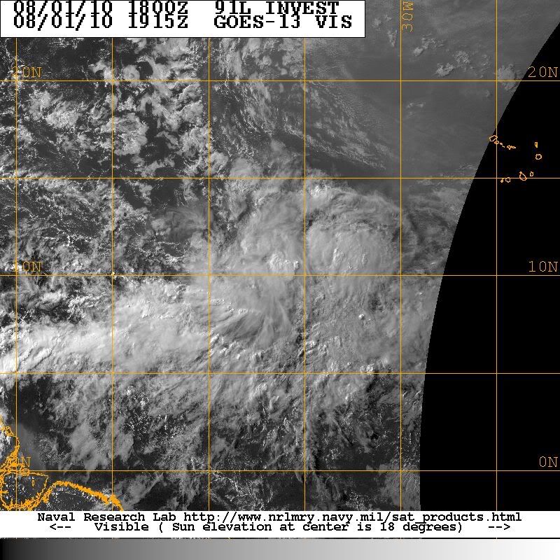
When a low pressure system closes off, yes, generally the convection will consolidate around the center. However, every tropical system is different and you can have a closed low with little convection and you can have no closed low with a lot of convection.

As to 91L lifting out ... that depends on the atmosphere around it and the influence of various high pressure and low pressure systems. You have to think three dimensional and realize that the more developed a system becomes, the higher in the atmosphere it is, and the more prone it then becomes to the influences of wind currents at mutiple levels.

There are much smarter people than me on here who can opine better, I'm sure. :wink:


scotto wrote:2 Questions?

- When a low 'closes' will there be a flare-up of convection over the center or it's perimeter?

- Is it the rotation that may cause 91L to lift out? The stronger the rotation the more north it moves?

:?: Thanks
0 likes   


Return to “2010”

Who is online

Users browsing this forum: No registered users and 4 guests