ATL: TROPICAL DEPRESSION BONNIE - DISCUSSION

Moderator: S2k Moderators

Message
Author
poof121
Category 1
Category 1
Posts: 316
Age: 44
Joined: Tue Sep 11, 2007 11:33 am
Location: Laurel, MD

Re: ATL: TROPICAL DEPRESSION THREE - DISCUSSION

#1921 Postby poof121 » Thu Jul 22, 2010 2:33 pm

imetrice wrote:Forgive my ignorance, but I am confused about the intensity forcasting of this storm. Are they still expecting it to make landfall as a weak system/tropical storm, or is there any possibilty that this coud become a hurricane?


No model I've seen indicates it becoming a hurricane, but intensity forecasts are no where near as accurate as position forecasts. So, yes, I'd say there is a possibility of a hurricane.

Mod question: Do I need the disclaimer on these types of posts?
0 likes   

Javlin
Category 5
Category 5
Posts: 1620
Age: 64
Joined: Fri Jul 09, 2004 7:58 pm
Location: ms gulf coast

Re: ATL: TROPICAL DEPRESSION THREE - DISCUSSION

#1922 Postby Javlin » Thu Jul 22, 2010 2:34 pm

The clouds are saying NW for the time being in the WV image.The ULL besides the shear it is imparting I believe is also changing the direction and as has been noted models do not deal with ULL well.

http://www.goes.noaa.gov/browsh3.html
0 likes   

User avatar
ROCK
Category 5
Category 5
Posts: 9484
Age: 54
Joined: Tue Aug 17, 2004 7:30 am
Location: Kemah, Texas

Re: ATL: TROPICAL DEPRESSION THREE - DISCUSSION

#1923 Postby ROCK » Thu Jul 22, 2010 2:35 pm

ridge building in so if its going to make a run NW its running out of time....WV shows this fairly evident....once it does build in an increase in forward speed and the TUTT feature will keep it in check... I do think a sw jog is coming though....
0 likes   

User avatar
SFLcane
S2K Supporter
S2K Supporter
Posts: 10163
Age: 47
Joined: Sat Jun 05, 2010 1:44 pm
Location: Lake Worth Florida

Re: Re:

#1924 Postby SFLcane » Thu Jul 22, 2010 2:35 pm

Aric Dunn wrote:
Bocadude85 wrote:
Aric Dunn wrote:I love that Ne motion/reforming of the center.. I dont think its done yet..


How big of an effect will this have on future track?


well essentially the forecast reasoning is the same .. just take the track exactly the way it is and shift it north..


Aric can you create a map showing were you think the latest center might be? appreciate it
0 likes   

redfish1
Tropical Storm
Tropical Storm
Posts: 125
Age: 44
Joined: Thu Jun 17, 2010 9:24 pm
Location: Port Arthur, Tx

Re: ATL: TROPICAL DEPRESSION THREE - DISCUSSION

#1925 Postby redfish1 » Thu Jul 22, 2010 2:36 pm

ROCK wrote:ridge building in so if its going to make a run NW its running out of time....WV shows this fairly evident....once it does build in an increase in forward speed and the TUTT feature will keep it in check... I do think a sw jog is coming though....


thank you
0 likes   

User avatar
Ivanhater
Storm2k Moderator
Storm2k Moderator
Posts: 11162
Age: 38
Joined: Fri Jul 01, 2005 8:25 am
Location: Pensacola

Re: ATL: TROPICAL DEPRESSION THREE - DISCUSSION

#1926 Postby Ivanhater » Thu Jul 22, 2010 2:37 pm

A little tid bit from JB for you South Florida folks

THURSDAY:
LOOK AT THIS FROM KEY WEST:

...WINDS AND SEAS... AS TROPICAL DEPRESSION THREE APPROACHES...SUSTAINED TROPICAL STORM FORCE WINDS ARE EXPECTED TO BEGIN LATE FRIDAY MORNING. SEAS OF 8 TO 12 FEET FRIDAY MORNING MAY BUILD TO 10 TO 16 FEET BY FRIDAY AFTERNOON.

Now, there is little weather with and south of the center of this. The center is likely to go north of them. It's like what we saw with warnings on the Mexican coast with Alex and TD 2.

I expect wind gusts from Miami to Ft. Pierce to average over 35 knots but I would be surprised if I see one over 20 knots at eyw, when the storm is within 100 miles of them.

Ciao for now.
0 likes   
Michael

User avatar
ROCK
Category 5
Category 5
Posts: 9484
Age: 54
Joined: Tue Aug 17, 2004 7:30 am
Location: Kemah, Texas

Re: ATL: TROPICAL DEPRESSION THREE - DISCUSSION

#1927 Postby ROCK » Thu Jul 22, 2010 2:38 pm

Ivanhater wrote:You won't see any SW motion. The ridge looks to be oriented SE to NW..not straight west to east.


Ivan, look at the WV for central US....here....ridge already starting to flatten out the NE rain shield as it builds in around the TUTT..as soon as the TUTT feature moves off some.


http://www.ssd.noaa.gov/goes/comp/ceus/flash-wv.html
Last edited by ROCK on Thu Jul 22, 2010 2:39 pm, edited 1 time in total.
0 likes   

User avatar
StormTracker
S2K Supporter
S2K Supporter
Posts: 2903
Age: 59
Joined: Thu Jun 29, 2006 6:06 am
Location: Quail Heights(Redlands), FL.

Re: Re:

#1928 Postby StormTracker » Thu Jul 22, 2010 2:39 pm

Aric Dunn wrote:
Bocadude85 wrote:
Aric Dunn wrote:I love that Ne motion/reforming of the center.. I dont think its done yet..


How big of an effect will this have on future track?


well essentially the forecast reasoning is the same .. just take the track exactly the way it is and shift it north..

Thank you Aric! That's what I've been talkin' about for the 2 pages of this thread!
0 likes   
Something's wrong when you regret, things that haven't happened yet!

Air Force Met
Military Met
Military Met
Posts: 4372
Age: 56
Joined: Tue Jul 08, 2003 9:30 am
Location: Roan Mountain, TN

Re: ATL: TROPICAL DEPRESSION THREE - DISCUSSION

#1929 Postby Air Force Met » Thu Jul 22, 2010 2:40 pm

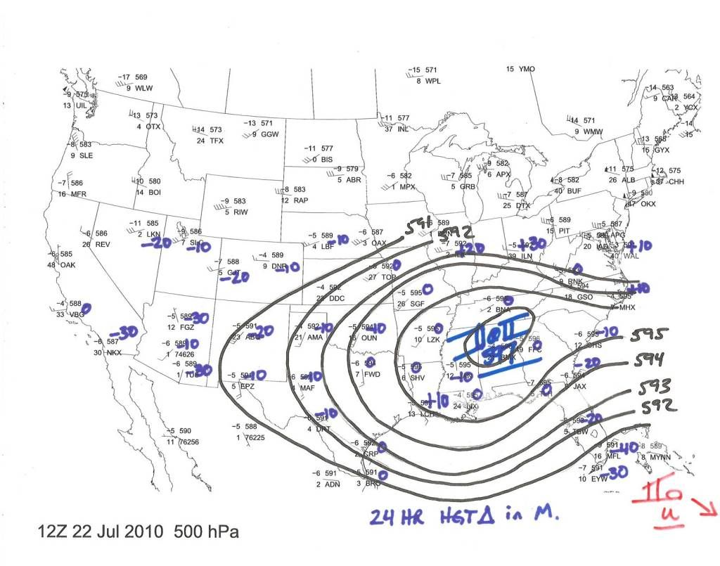
Ivanhater wrote:You won't see any SW motion. The ridge looks to be oriented SE to NW..not straight west to east.


Not the ridge I analyzed...although I do doubt any SW motion...I could certianly see a WSW motion at some point.


Image
0 likes   

Aric Dunn
Category 5
Category 5
Posts: 21238
Age: 42
Joined: Sun Sep 19, 2004 9:58 pm
Location: Ready for the Chase.
Contact:

#1930 Postby Aric Dunn » Thu Jul 22, 2010 2:42 pm

latest recon pass.. the center still moving/migrating/reforming essentially north...
0 likes   

User avatar
Ivanhater
Storm2k Moderator
Storm2k Moderator
Posts: 11162
Age: 38
Joined: Fri Jul 01, 2005 8:25 am
Location: Pensacola

Re: ATL: TROPICAL DEPRESSION THREE - DISCUSSION

#1931 Postby Ivanhater » Thu Jul 22, 2010 2:43 pm

Lol Rock..I win either way :lol:

Ahh good stuff AF, I would think a stronger storm, a hurricane, would feel that ridge stronger and possibly move SW, but not a tropical storm. I could be wrong though :)

I believe the ridge is supposed to relax though by day 3?
0 likes   
Michael

User avatar
tailgater
S2K Supporter
S2K Supporter
Posts: 3339
Joined: Sun Jul 11, 2004 9:13 pm
Location: St. Amant La.

Re: ATL: INVEST 97L - DISCUSSION

#1932 Postby tailgater » Thu Jul 22, 2010 2:46 pm

tailgater wrote:This is about where I think it is
Image

That was at about first light.
Now
Image
Last edited by tailgater on Thu Jul 22, 2010 2:47 pm, edited 1 time in total.
0 likes   
The following post is NOT an official forecast and should not be used as such. It is just the opinion of the poster and may or may not be backed by sound meteorological data. It is NOT endorsed by any professional institution including storm2k.org For Official Information please refer to the NHC and NWS products.

User avatar
southerngale
Retired Staff
Retired Staff
Posts: 27418
Joined: Thu Oct 10, 2002 1:27 am
Location: Southeast Texas (Beaumont area)

Re: ATL: TROPICAL DEPRESSION THREE - DISCUSSION

#1933 Postby southerngale » Thu Jul 22, 2010 2:46 pm

poof121 wrote:
imetrice wrote:Forgive my ignorance, but I am confused about the intensity forcasting of this storm. Are they still expecting it to make landfall as a weak system/tropical storm, or is there any possibilty that this coud become a hurricane?


No model I've seen indicates it becoming a hurricane, but intensity forecasts are no where near as accurate as position forecasts. So, yes, I'd say there is a possibility of a hurricane.

Mod question: Do I need the disclaimer on these types of posts?


No, not for general comments. You need it for forecasts.
0 likes   
Please support Storm2k by making a donation today. It is greatly appreciated! Click here: Image

Image my Cowboys Image my RocketsImage my Astros

Aric Dunn
Category 5
Category 5
Posts: 21238
Age: 42
Joined: Sun Sep 19, 2004 9:58 pm
Location: Ready for the Chase.
Contact:

Re: ATL: TROPICAL DEPRESSION THREE - DISCUSSION

#1934 Postby Aric Dunn » Thu Jul 22, 2010 2:47 pm

Shear down to near nothing in the upper levels.. and in down under 10kts in the mid levels .. well besides a little stable air ingested atm there is not much inhibitors now at least according what i have seen...

mid level
Image

upper levels
Image
0 likes   

User avatar
Ivanhater
Storm2k Moderator
Storm2k Moderator
Posts: 11162
Age: 38
Joined: Fri Jul 01, 2005 8:25 am
Location: Pensacola

Re: ATL: TROPICAL DEPRESSION THREE - DISCUSSION

#1935 Postby Ivanhater » Thu Jul 22, 2010 2:48 pm

BTW, no model even goes due west, they go wnw which leads me to believe the ridge is nor oriented straight west, but I defer to AF :D
0 likes   
Michael

redfish1
Tropical Storm
Tropical Storm
Posts: 125
Age: 44
Joined: Thu Jun 17, 2010 9:24 pm
Location: Port Arthur, Tx

Re: ATL: TROPICAL DEPRESSION THREE - DISCUSSION

#1936 Postby redfish1 » Thu Jul 22, 2010 2:48 pm

i still think it is going to shoot through the strait
0 likes   

Frank2
Category 5
Category 5
Posts: 4061
Joined: Mon Jul 25, 2005 12:47 pm

#1937 Postby Frank2 » Thu Jul 22, 2010 2:49 pm

Vortex message shows what it appeared to be on the VIS when the first advisory was issued - a modest TD...
0 likes   

User avatar
MGC
S2K Supporter
S2K Supporter
Posts: 5899
Joined: Sun Mar 23, 2003 9:05 pm
Location: Pass Christian MS, or what is left.

Re: ATL: TROPICAL DEPRESSION THREE - DISCUSSION

#1938 Postby MGC » Thu Jul 22, 2010 2:50 pm

Well, let me say that I didn't expect a center to close off this far east....anyway, looking at the visable loop....looks to me like the system is a bit north of where it was earlier. Upper keys to extreme south Florida south of Miami looks like a good landfall point as a weak TS. Thinking mouth of Miss River west to Galvenston is at greatest risk.......MGC
0 likes   

User avatar
Tireman4
S2K Supporter
S2K Supporter
Posts: 5853
Age: 59
Joined: Fri Jun 30, 2006 1:08 pm
Location: Humble, Texas
Contact:

Re: ATL: TROPICAL DEPRESSION THREE - DISCUSSION

#1939 Postby Tireman4 » Thu Jul 22, 2010 2:51 pm

I trust AFM and Wxman57. :) Thank you and good night. LOL
0 likes   

User avatar
lester
S2K Supporter
S2K Supporter
Posts: 1305
Age: 36
Joined: Sat Aug 27, 2005 5:21 pm
Location: Washington, DC
Contact:

Re:

#1940 Postby lester » Thu Jul 22, 2010 2:51 pm

Frank2 wrote:Vortex message shows what it appeared to be on the VIS when the first advisory was issued - a modest TD...


They haven't been over the NE quad yet -- where the strongest winds usually are..
0 likes   


Return to “2010”

Who is online

Users browsing this forum: No registered users and 5 guests