12z Best Track
AL, 97, 2010093012, , BEST, 0, 120N, 485W, 25, 1009, DB
ftp://ftp.tpc.ncep.noaa.gov/atcf/tcweb/ ... 010.invest
ATL: OTTO - Post-tropical - Discussion
Moderator: S2k Moderators
-
cycloneye

- Admin

- Posts: 149581
- Age: 69
- Joined: Thu Oct 10, 2002 10:54 am
- Location: San Juan, Puerto Rico
Re: ATL: INVEST 97L - Discussion - (Code Orange)
0 likes
Visit the Caribbean-Central America Weather Thread where you can find at first post web cams,radars
and observations from Caribbean basin members Click Here
and observations from Caribbean basin members Click Here
-
Gustywind

- Category 5

- Posts: 12334
- Joined: Mon Sep 03, 2007 7:29 am
- Location: Baie-Mahault, GUADELOUPE
Re: ATL: INVEST 97L - Discussion - (Code Orange)
cycloneye wrote:12z Best Track
AL, 97, 2010093012, , BEST, 0, 120N, 485W, 25, 1009, DB
ftp://ftp.tpc.ncep.noaa.gov/atcf/tcweb/ ... 010.invest
That's pretty south
0 likes


-
wxman57

- Moderator-Pro Met

- Posts: 23175
- Age: 68
- Joined: Sat Jun 21, 2003 8:06 pm
- Location: Houston, TX (southwest)
Re: ATL: INVEST 97L - Discussion - (Code Orange)
Shows up very well on the MIMIC-TPW loop. Check out the "breaking wave" near 14N/43W. Note that it is now past 45W.
http://cimss.ssec.wisc.edu/tropic/real- ... /main.html
http://cimss.ssec.wisc.edu/tropic/real- ... /main.html
0 likes

Re: ATL: INVEST 97L - Discussion - (Code Orange)
Strong TUTT to the north at 31N 58W creating strong shear to the north of the LLC.
http://www.goes.noaa.gov/HURRLOOPS/huwvloop.html
GFS shows it moving NW and dissipating in 42 hrs.
Another TUTT is forecast to reform in 72 hrs at 21N 58W with a UL High to its NE.
97L should be to the south or southwest of the TUTT then at that time.
At that point, based on actual positions, 97L's ventilation may begin to be enhanced by the TUTT.
0 likes
-
bvigal

- S2K Supporter

- Posts: 2276
- Joined: Sun Jul 24, 2005 8:49 am
- Location: British Virgin Islands
- Contact:
Re: ATL: INVEST 97L - Discussion - (Code Orange)
Good morning! 
Hi Boca! I wouldn't put too much stock in any of the models just yet... the changes in TWO from 2 to 8am indicates we may see some changes in fix points for model runs. Hopefully by this evening we'll have a better picture just what to expect. Even if cyclone development in future, it's primarily a concern for the islands right now. This could be one of those systems that forms with little or no lead time for us, moves into the area and then upper level conditions improve and it bombs and becomes quite nasty. (I think it will be nasty either way.)boca wrote:Nah this will go north of the islands
http://my.sfwmd.gov/sfwmd/common/images ... orm_97.gif

0 likes
Re: ATL: INVEST 97L - Discussion - (Code Orange)
Here's an up-to-date LLC.
Some discrepency with respect to Best Track and still looks more like a wave.

Some discrepency with respect to Best Track and still looks more like a wave.
0 likes
-
otowntiger
- Category 5
- Posts: 1932
- Joined: Tue Aug 31, 2004 7:06 pm
Re: ATL: INVEST 97L - Discussion - (Code Orange)
wxman57 wrote:Shows up very well on the MIMIC-TPW loop. Check out the "breaking wave" near 14N/43W. Note that it is now past 45W.
http://cimss.ssec.wisc.edu/tropic/real- ... /main.html
That's cool! So I guess its a wave both literally and figuratively and graphically as depicted in that image. There does appeat to be some twisting going on.
0 likes
Re: ATL: INVEST 97L - Discussion - (Code Orange)
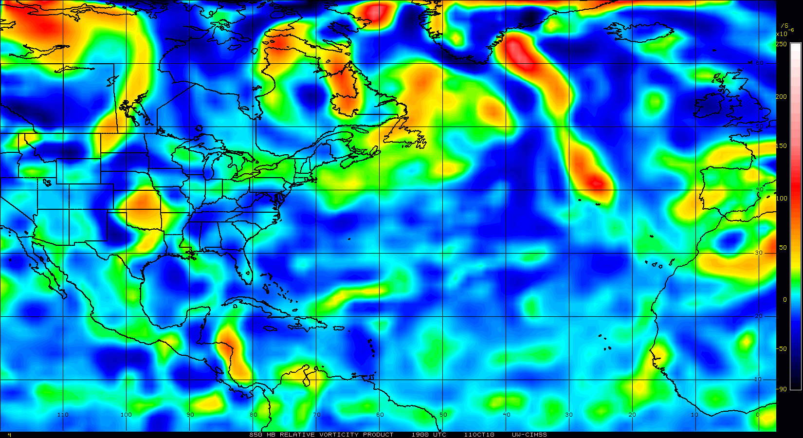
Very broad and relatively weak on 850mb vorticity
0 likes
-
cycloneye
- Admin
- Posts: 149581
- Age: 69
- Joined: Thu Oct 10, 2002 10:54 am
- Location: San Juan, Puerto Rico
Re: ATL: INVEST 97L - Discussion - (Code Orange)
GCANE, I suspect the best track position will be changed as until this moment, the 12z model guidance by the Bams has not been released. (Maybe waiting for data from the Predict team plane?)
0 likes
Visit the Caribbean-Central America Weather Thread where you can find at first post web cams,radars
and observations from Caribbean basin members Click Here
and observations from Caribbean basin members Click Here
Re: ATL: INVEST 97L - Discussion - (Code Orange)
I'd give it another day to see how much it comes together vs the front that is parked over GOM.
0 likes

Its very broad from the looks of things, I suspect we may well get some development but that may well be someway down the line yet once it gets to the north of the Caribbean....
Most models do show some sort of broad low developing from this region...
Most models do show some sort of broad low developing from this region...
0 likes
Personal Forecast Disclaimer:
The posts in this forum are NOT official forecast and should not be used as such. They are just the opinion of the poster and may or may not be backed by sound meteorological data. They are NOT endorsed by any professional institution or storm2k.org. For official information, please refer to the NHC and NWS products
The posts in this forum are NOT official forecast and should not be used as such. They are just the opinion of the poster and may or may not be backed by sound meteorological data. They are NOT endorsed by any professional institution or storm2k.org. For official information, please refer to the NHC and NWS products
-
ConvergenceZone
.gif)
- Category 5
- Posts: 5241
- Joined: Fri Jul 29, 2005 1:40 am
- Location: Northern California
Re:
KWT wrote:Its very broad from the looks of things, I suspect we may well get some development but that may well be someway down the line yet once it gets to the north of the Caribbean....
Most models do show some sort of broad low developing from this region...
looks like a US threat down the road.....
0 likes
Too early to say CZ, we are now nearly in October and troughs could very easily recurve a system at this time of year...but I'd certainly say there is a big threat to the central Caribbean and possibly the Bahamas as well...who knows whether it'll get closer then that its just too early to say.
0 likes
Personal Forecast Disclaimer:
The posts in this forum are NOT official forecast and should not be used as such. They are just the opinion of the poster and may or may not be backed by sound meteorological data. They are NOT endorsed by any professional institution or storm2k.org. For official information, please refer to the NHC and NWS products
The posts in this forum are NOT official forecast and should not be used as such. They are just the opinion of the poster and may or may not be backed by sound meteorological data. They are NOT endorsed by any professional institution or storm2k.org. For official information, please refer to the NHC and NWS products
-
ConvergenceZone
- Category 5
- Posts: 5241
- Joined: Fri Jul 29, 2005 1:40 am
- Location: Northern California
Re:
KWT wrote:Too early to say CZ, we are now nearly in October and troughs could very easily recurve a system at this time of year...but I'd certainly say there is a big threat to the central Caribbean and possibly the Bahamas as well...who knows whether it'll get closer then that its just too early to say.
Oops sorry KWT, I must have been confusing this with the carib system that the models are saying is going to slam into the US in a few days....I thought this was the one. The ones the models are predicting to his the US must be from a different wave...
0 likes

Re: ATL: INVEST 97L - Discussion - (Code Orange)
Looks like a cutoff low may form in the SW around Tuesday and stall thru at least Thursday next week.
http://www.hpc.ncep.noaa.gov/preepd/preepd.html


http://www.hpc.ncep.noaa.gov/preepd/preepd.html
0 likes

-
Typhoon_Willie

- Category 5
- Posts: 1042
- Joined: Mon Jun 09, 2003 3:19 pm
- Location: Greenacres City, Florida
Re: ATL: INVEST 97L - Discussion - (Code Orange)
Yeah canes it does look a little bit suspect there.
0 likes
-
plasticup
Who is online
Users browsing this forum: No registered users and 33 guests