SPO: TROPICAL CYCLONE ULUI (13F/20P)

Moderator: S2k Moderators

Message
Author
User avatar
HURAKAN
Professional-Met
Professional-Met
Posts: 46086
Age: 38
Joined: Thu May 20, 2004 4:34 pm
Location: Key West, FL
Contact:

Re: SPO: TROPICAL CYCLONE ULUI (13F/20P)

#201 Postby HURAKAN » Fri Mar 19, 2010 11:25 pm

TROPICAL CYCLONE ADVICE NUMBER 13
Issued by the Bureau of Meteorology, Brisbane
Issued at 1:55pm EST on Saturday the 20th of March 2010

A Cyclone WARNING is now current for coastal areas from Cardwell to Yeppoon and
inland including Charters Towers and Clermont.
A Cyclone WATCH is current for areas extending further inland of the warning
area.

At 1:00 pm EST Tropical Cyclone Ului, Category 2 was estimated to be
365 kilometres east northeast of Mackay and
580 kilometres east of Townsville and
moving west southwest at 27 kilometres per hour.

The cyclone is expected to cross the coast between Ayr and Mackay early Sunday,
possibly re-intensifying to a Category 3 system before landfall. The cyclone is
then expected to weaken inland later on Sunday.

VERY DESTRUCTIVE wind gusts to 170 km/hr near the cyclone centre may affect
coastal and island communities in the threatened area early Sunday.

DAMAGING winds are expected to develop between Cardwell and Yeppoon later today,
then extend to adjacent inland parts on Sunday.

TIDES between Bowen and St Lawrence may rise to just above the normal high tide
mark overnight with very rough seas and dangerous conditions along the
foreshore.

HEAVY RAINFALL and flooding are likely to develop about coastal and adjacent
inland areas between Bowen and St Lawrence early Sunday.

DANGEROUS SURF conditions are expected to continue about exposed beaches south
of the cyclone until later on Sunday. A separate Severe Weather Warning is
current for these conditions.

People between Cardwell and Yeppoon and inland including Charters Towers and
Clermont should complete preparations quickly and be prepared to shelter in a
safe place.
- Boats and outside property should be secured before nightfall.

People further inland of the warning area should consider what action they will
need to take if the cyclone threat increases.
- Information is available from your local government

- For cyclone preparedness and safety advice, visit Queensland's Disaster
Management Services
website [www.disaster.qld.gov.au].
- For emergency assistance call the Queensland State Emergency Service [SES] on
132 500 [for assistance with storm damage, rising flood water, fallen trees on
buildings or roof damage]

Details of Tropical Cyclone Ului at 1:00 pm EST:
.Centre located near...... 19.7 degrees South 152.3 degrees East
.Location accuracy........ within 35 kilometres
.Recent movement.......... towards the west southwest at 27 kilometres per hour
.Wind gusts near centre... 155 kilometres per hour
.Severity category........ 2
.Central pressure......... 978 hectoPascals

Please ensure that neighbours have heard and understood this message,
particularly new arrivals or those who may not fully understand English.

The next advice will be issued by 5:00 pm EST Saturday 20 March.

This warning is also available through TV and Radio Broadcasts; the Bureau's
website at http://www.bom.gov.au or call 1300 659 212. The Bureau and the State
Emergency Service would appreciate this warning being broadcast regularly.


Image
0 likes   

User avatar
Tom8
Tropical Storm
Tropical Storm
Posts: 195
Joined: Sun Aug 19, 2007 4:36 pm
Location: Poland,Slupsk
Contact:

Re: SPO: TROPICAL CYCLONE ULUI (13F/20P)

#202 Postby Tom8 » Sat Mar 20, 2010 5:57 am

The cyclone is predicted to cross the coast between Ayr and Mackay as a category two or three system early on Sunday, bringing destructive wind gusts of up to 170km/h.

The Bureau of Meteorology has warned that up to 300mm of rain is possible in areas located in the path of the cyclone.

Premier Anna Bligh has declared a disaster zone across the state's central and northern coast ahead of the anticipated arrival of tropical cyclone Ului.

Ms Bligh announced disaster declarations for the Townsville, Burdekin, Whitsunday, Charters Towers, Mackay, Isaac, Rockhampton and Central Highlands local government areas.

"This declaration is in anticipation that some properties may need to be evacuated in the coming hours as Tropical Cyclone Ului approaches and then crosses the North Queensland coast," Ms Bligh said.

"The declaration gives Emergency Services agencies the power of mandatory evacuations if required."

Residents in the likely path of the cyclone were today making final preparations for Ului's arrival.

Store owners in Airlie Beach and Bowen used masking tape to reinforce shopfront windows while locals flocked to supermarkets to buy last-minute supplies.

In Townsville staff at the Lennon Bros Circus were preparing to pull down their big top tent after Saturday night's show to avoid damage.

"It's a big concern, we don't want to lose our big top so we are cancelling our shows tomorrow and pulling down the big top," owner Jay Lennon said.

Mr Lennon said staff would position the trucks and trailers to shield the circus animals from the wind gusts.

"We'll take every precaution with the animals and our staff as well."

For information visit http://www.disaster.qld.gov.au

http://www.news.com.au/national/disaste ... 5843168640
0 likes   

User avatar
Tom8
Tropical Storm
Tropical Storm
Posts: 195
Joined: Sun Aug 19, 2007 4:36 pm
Location: Poland,Slupsk
Contact:

Re: SPO: TROPICAL CYCLONE ULUI (13F/20P)

#203 Postby Tom8 » Sat Mar 20, 2010 6:22 am

Image
0 likes   

User avatar
KWT
Category 5
Category 5
Posts: 31415
Joined: Tue Aug 17, 2004 11:02 am
Location: UK!!!

#204 Postby KWT » Sat Mar 20, 2010 6:40 am

We have a strengthening TC heading towards landfall, never a good thing!

Anyway I heard Coral Reef saw a sustained wind of 73kts recently, which would mean it is strengthening pretty rapidly.
0 likes   
Personal Forecast Disclaimer:
The posts in this forum are NOT official forecast and should not be used as such. They are just the opinion of the poster and may or may not be backed by sound meteorological data. They are NOT endorsed by any professional institution or storm2k.org. For official information, please refer to the NHC and NWS products

User avatar
cycloneye
Admin
Admin
Posts: 143867
Age: 68
Joined: Thu Oct 10, 2002 10:54 am
Location: San Juan, Puerto Rico

Re: SPO: TROPICAL CYCLONE ULUI (13F/20P)

#205 Postby cycloneye » Sat Mar 20, 2010 7:22 am

0 likes   
Visit the Caribbean-Central America Weather Thread where you can find at first post web cams,radars
and observations from Caribbean basin members Click Here

User avatar
cycloneye
Admin
Admin
Posts: 143867
Age: 68
Joined: Thu Oct 10, 2002 10:54 am
Location: San Juan, Puerto Rico

Re: SPO: TROPICAL CYCLONE ULUI (13F/20P)

#206 Postby cycloneye » Sat Mar 20, 2010 7:48 am

Web cam from Mackay,Queensland.

Image

Radar from Mackay.

http://www.weatherzone.com.au/radar.jsp ... yk=1&lye=1
0 likes   
Visit the Caribbean-Central America Weather Thread where you can find at first post web cams,radars
and observations from Caribbean basin members Click Here

User avatar
HURAKAN
Professional-Met
Professional-Met
Posts: 46086
Age: 38
Joined: Thu May 20, 2004 4:34 pm
Location: Key West, FL
Contact:

#207 Postby HURAKAN » Sat Mar 20, 2010 9:04 am

TROPICAL CYCLONE TECHNICAL BULLETIN: AUSTRALIA - EASTERN REGION
Issued by BRISBANE TROPICAL CYCLONE WARNING CENTRE
at: 1249 UTC 20/03/2010
Name: Severe Tropical Cyclone Ului
Identifier: 09U
Data At: 1200 UTC
Latitude: 20.0S
Longitude: 149.6E
Location Accuracy: within 20 nm [35 km]
Movement Towards: west [268 deg]
Speed of Movement: 18 knots [32 km/h]
Maximum 10-Minute Wind: 80 knots [150 km/h]
Maximum 3-Second Wind Gust: 110 knots [205 km/h]
Central Pressure: 964 hPa
Radius of 34-knot winds NE quadrant: 90 nm [165 km]
Radius of 34-knot winds SE quadrant: 140 nm [260 km]
Radius of 34-knot winds SW quadrant: 120 nm [220 km]
Radius of 34-knot winds NW quadrant: 120 nm [220 km]
Radius of 48-knot winds NE quadrant: 50 nm [95 km]
Radius of 48-knot winds SE quadrant: 80 nm [150 km]
Radius of 48-knot winds SW quadrant: 70 nm [130 km]
Radius of 48-knot winds NW quadrant: 70 nm [130 km]
Radius of 64-knot winds: 40 nm [75 km]
Radius of Maximum Winds: 15 nm [30 km]
Dvorak Intensity Code: T4.5/4.5/D1.0/24HRS
Pressure of outermost isobar: 1006 hPa
Radius of outermost closed isobar: 130 nm [240 km]
Storm Depth: Deep
FORECAST DATA
Date/Time : Location : Loc. Accuracy: Max Wind : Central Pressure
[UTC] : degrees : nm [km]: knots[km/h]: hPa
+12: 21/0000: 20.7S 146.6E: 050 [095]: 050 [095]: 981
+24: 21/1200: 21.1S 143.8E: 080 [150]: 030 [055]: 1002
+36: 22/0000: 20.8S 140.9E: 115 [210]: 025 [045]: 1005
+48: 22/1200: 19.1S 138.0E: 145 [270]: 025 [045]: 1006
+60: 23/0000: 16.4S 135.1E: 195 [355]: 025 [045]: 1006
+72: 23/1200: 14.0S 134.0E: 240 [445]: 025 [045]: 1004
REMARKS:
Following a period of weakening due to northwesterly wind shear, Severe Tropical
Cyclone Ului has shown increased organisation in the last 6 to 12 hours with
strong banding evident in the most recent satellite images.

Dvorak analysis: Embedded centre pattern has been adopted over the past few
satellite images with LG surround, giving a DT of 4.5. This pattern is also
supported by nearby surface observations. The most recent image suggests a
possible eye pattern developing with MG and OW white, which also yields a DT of
4.5. MET and PT suggest 4.0 and 4.5 respectively. FT based on DT as it appears
clear.

The cyclone is expected to weaken as it moves inland during Sunday.


Copyright Commonwealth of Australia
==
The next bulletin for this system will be issued by: 20/1900 UTC by Brisbane
0 likes   

User avatar
HURAKAN
Professional-Met
Professional-Met
Posts: 46086
Age: 38
Joined: Thu May 20, 2004 4:34 pm
Location: Key West, FL
Contact:

#208 Postby HURAKAN » Sat Mar 20, 2010 9:05 am

Australian Government Bureau of Meteorology
Queensland
Tropical Cyclone Warning Centre

Media: Transmitters serving the area between Cardwell to Yeppoon and inland to
Hughenden, including Charters Towers and Clermont are requested to USE the
Standard Emergency Warning Signal before broadcasting the following warning.

TOP PRIORITY
TROPICAL CYCLONE ADVICE NUMBER 19
Issued by the Bureau of Meteorology, Brisbane
Issued at 11:58pm EST on Saturday the 20th of March 2010

A Cyclone WARNING continues for coastal areas from Cardwell to Yeppoon and
inland to Hughenden, including Charters Towers and Clermont.

At 11:00 pm EST Severe Tropical Cyclone Ului, Category 3 was estimated to be
135 kilometres north of Mackay and
280 kilometres east southeast of Townsville and
moving west at 31 kilometres per hour.

At 12:00 am EST Sunday the cyclone is estimated to be
93 kilometres east of Bowen and
127 kilometres north of Mackay.

The cyclone is expected to cross the coast as a severe tropical cyclone between
Ayr and Mackay, most likely between Bowen and Proserpine within the next few
hours. The cyclone is then expected to weaken inland later today.

VERY DESTRUCTIVE wind gusts to 200 km/hr near the cyclone centre may affect
coastal and island communities between Ayr and Seaforth over the next few hours.

DAMAGING winds are expected to continue in areas between Cardwell and Yeppoon,
then extend to adjacent inland parts during today.

TIDES between Bowen and St Lawrence are expected to rise above the highest tide
of the year overnight with very rough seas and dangerous conditions along the
foreshore.

HEAVY RAINFALL and flooding are likely to continue about coastal and adjacent
inland areas between Bowen and St Lawrence.

DANGEROUS SURF conditions are expected to continue about exposed beaches south
of the cyclone until later today. A separate Severe Weather Warning is
current for these conditions.

People in the path of the dangerous cyclone should stay calm and remain in a
secure shelter while the very destructive winds develop over the next few hours.
Do not venture outside if you find yourself in the eye of the cyclone as winds
may remain light for up to an hour - very destructive winds from a different
direction could resume at any time. Heed the advice and follow the instructions
of Police or State Emergency Service personnel.

People from Cardwell to Yeppoon and inland to Hughenden, including Charters
Towers and Clermont should have completed preparations and remain in secure
shelter.
.Boats and outside property should now be secured.
.For cyclone preparedness and safety advice, visit Queensland's Disaster
Management Services
website [www.disaster.qld.gov.au].
.For emergency assistance call the Queensland State Emergency Service [SES] on
132 500 [for assistance with storm damage, rising flood water, fallen trees on
buildings or roof damage]

Details of Severe Tropical Cyclone Ului at 11:00 pm EST:
.Centre located near...... 20.0 degrees South 149.4 degrees East
.Location accuracy........ within 35 kilometres
.Recent movement.......... towards the west at 31 kilometres per hour
.Wind gusts near centre... 205 kilometres per hour
.Severity category........ 3
.Central pressure......... 965 hectoPascals

The next advice will be issued by 1:00 am EST Sunday 21 March.

This warning is also available through TV and Radio Broadcasts; the Bureau's
website at http://www.bom.gov.au or call 1300 659 212. The Bureau and the State
Emergency Service would appreciate this warning being broadcast regularly.


Image
0 likes   

User avatar
HURAKAN
Professional-Met
Professional-Met
Posts: 46086
Age: 38
Joined: Thu May 20, 2004 4:34 pm
Location: Key West, FL
Contact:

#209 Postby HURAKAN » Sat Mar 20, 2010 9:08 am

Image

Image

Latest - NRL : 65 knots
0 likes   

CrazyC83
Professional-Met
Professional-Met
Posts: 34001
Joined: Tue Mar 07, 2006 11:57 pm
Location: Deep South, for the first time!

#210 Postby CrazyC83 » Sat Mar 20, 2010 10:09 am

Based on that wind report (assuming it is 10-min sustained) and extrapolation, I would guess 85 kt for the current intensity.
0 likes   

CrazyC83
Professional-Met
Professional-Met
Posts: 34001
Joined: Tue Mar 07, 2006 11:57 pm
Location: Deep South, for the first time!

#211 Postby CrazyC83 » Sat Mar 20, 2010 10:13 am

According to the Wunderground map, Hamilton Island is reporting sustained (unclear if 1-min or 10-min) winds of 77 kt. A nearby station is reporting 72 kt with a pressure of 977mb. That suggests the central pressure is around 969mb right now.
0 likes   

User avatar
KWT
Category 5
Category 5
Posts: 31415
Joined: Tue Aug 17, 2004 11:02 am
Location: UK!!!

#212 Postby KWT » Sat Mar 20, 2010 10:19 am

Either way clear as day this is stronger then 65kts, which is really rather obvious given we were having reports of sustained winds from Coral reef of around 70kts earlier today.

I'd say 80-85kts isn't a bad estimate right now, certainly goes to show you can never write off these systems till they are on land.
0 likes   
Personal Forecast Disclaimer:
The posts in this forum are NOT official forecast and should not be used as such. They are just the opinion of the poster and may or may not be backed by sound meteorological data. They are NOT endorsed by any professional institution or storm2k.org. For official information, please refer to the NHC and NWS products

CrazyC83
Professional-Met
Professional-Met
Posts: 34001
Joined: Tue Mar 07, 2006 11:57 pm
Location: Deep South, for the first time!

Re:

#213 Postby CrazyC83 » Sat Mar 20, 2010 10:24 am

KWT wrote:Either way clear as day this is stronger then 65kts, which is really rather obvious given we were having reports of sustained winds from Coral reef of around 70kts earlier today.

I'd say 80-85kts isn't a bad estimate right now, certainly goes to show you can never write off these systems till they are on land.


A strengthening storm tends to easily bring the winds down to the surface as well. This could easily make it to (our) Cat 3 before landfall at this rate - and that assumes this doesn't pull a Charley on approach.
0 likes   

CrazyC83
Professional-Met
Professional-Met
Posts: 34001
Joined: Tue Mar 07, 2006 11:57 pm
Location: Deep South, for the first time!

#214 Postby CrazyC83 » Sat Mar 20, 2010 10:35 am

According to http://www.wunderground.com/history/sta ... story.html - Hamilton Island at one point reported 172 km/h (107 mph, 93 kt) winds, which appear to have been 1-min sustained.

That supports an intensity of 95 kt for the storm. Based on the surface information, the pressure is likely around 966mb as well if that was in the eyewall, a bit lower if not. I would go with 964mb.
Last edited by CrazyC83 on Sat Mar 20, 2010 10:49 am, edited 1 time in total.
0 likes   

User avatar
HURAKAN
Professional-Met
Professional-Met
Posts: 46086
Age: 38
Joined: Thu May 20, 2004 4:34 pm
Location: Key West, FL
Contact:

#215 Postby HURAKAN » Sat Mar 20, 2010 10:38 am

TROPICAL CYCLONE ADVICE NUMBER 20
Issued by the Bureau of Meteorology, Brisbane
Issued at 12:52am EST on Sunday the 21st of March 2010

A Cyclone WARNING continues for coastal areas from Cardwell to Yeppoon and
inland to Hughenden, including Charters Towers and Clermont.

At 12:00 am EST Severe Tropical Cyclone Ului, Category 3 was estimated to be
130 kilometres north of Mackay and
260 kilometres east southeast of Townsville and
moving west at 30 kilometres per hour.

At 1:00 am EST the cyclone is estimated to be
69 kilometres east of Bowen and
125 kilometres north northwest of Mackay.

The cyclone is currently crossing the Whitsunday Islands as a severe tropical
cyclone and is expected to move west and make landfall Bowen and Proserpine in
the next hour. The cyclone is then expected to weaken as it moves inland later
today.

VERY DESTRUCTIVE wind gusts to 200 km/hr near the cyclone centre currently
affecting the Whitsunday Islands and will affect coastal and island communities
between Ayr and Seaforth over the next few hours.

DAMAGING winds are expected in areas between Cardwell and Yeppoon over the next
few hours, then extending to adjacent inland parts during today.

TIDES between Bowen and St Lawrence are expected to rise above the highest tide
of the year overnight with very rough seas and dangerous conditions along the
foreshore.

HEAVY RAINFALL and flooding are likely to continue about coastal and adjacent
inland areas between Bowen and St Lawrence.

DANGEROUS SURF conditions are expected to continue about exposed beaches south
of the cyclone until later today. A separate Severe Weather Warning is
current for these conditions.


People in the path of the dangerous cyclone should stay calm and remain in a
secure shelter while the very destructive winds develop over the next few hours.
Do not venture outside if you find yourself in the eye of the cyclone as winds
may remain light for up to an hour - very destructive winds from a different
direction could resume at any time. Heed the advice and follow the instructions
of Police or State Emergency Service personnel.

People from Cardwell to Yeppoon and inland to Hughenden, including Charters
Towers and Clermont should have completed preparations and remain in secure
shelter.
.Boats and outside property should now be secured.
.For cyclone preparedness and safety advice, visit Queensland's Disaster
Management Services
website [www.disaster.qld.gov.au].
.For emergency assistance call the Queensland State Emergency Service [SES] on
132 500 [for assistance with storm damage, rising flood water, fallen trees on
buildings or roof damage]

Details of Severe Tropical Cyclone Ului at 12:00 am EST:
.Centre located near...... 20.0 degrees South 149.2 degrees East
.Location accuracy........ within 30 kilometres
.Recent movement.......... towards the west at 30 kilometres per hour
.Wind gusts near centre... 205 kilometres per hour
.Severity category........ 3
.Central pressure......... 965 hectoPascals

The next advice will be issued by 2:00 am EST Sunday 21 March.

This warning is also available through TV and Radio Broadcasts; the Bureau's
website at http://www.bom.gov.au or call 1300 659 212. The Bureau and the State
Emergency Service would appreciate this warning being broadcast regularly


Image
0 likes   

User avatar
HURAKAN
Professional-Met
Professional-Met
Posts: 46086
Age: 38
Joined: Thu May 20, 2004 4:34 pm
Location: Key West, FL
Contact:

#216 Postby HURAKAN » Sat Mar 20, 2010 10:49 am

Image

Latest
0 likes   

User avatar
HURAKAN
Professional-Met
Professional-Met
Posts: 46086
Age: 38
Joined: Thu May 20, 2004 4:34 pm
Location: Key West, FL
Contact:

#217 Postby HURAKAN » Sat Mar 20, 2010 10:50 am

Image

NRL - 75 knots
0 likes   

CrazyC83
Professional-Met
Professional-Met
Posts: 34001
Joined: Tue Mar 07, 2006 11:57 pm
Location: Deep South, for the first time!

#218 Postby CrazyC83 » Sat Mar 20, 2010 10:50 am

Trying to wrap a back eyewall but land interaction (and remaining shear perhaps?) is preventing it. Still, that front eyewall is really intense. The TRMM pass is about 2 1/2 hours old, and current satellite definitely looks stronger.

I guess the NRL didn't see that wind report from Hamilton Island (supporting a 95 kt intensity), or it came out too late for its estimate.
Last edited by CrazyC83 on Sat Mar 20, 2010 10:52 am, edited 1 time in total.
0 likes   

User avatar
HURAKAN
Professional-Met
Professional-Met
Posts: 46086
Age: 38
Joined: Thu May 20, 2004 4:34 pm
Location: Key West, FL
Contact:

#219 Postby HURAKAN » Sat Mar 20, 2010 10:52 am

20/1430 UTC 20.4S 149.4E T4.5/4.5 ULUI -- Southwest Pacific

75 knots
0 likes   

User avatar
HURAKAN
Professional-Met
Professional-Met
Posts: 46086
Age: 38
Joined: Thu May 20, 2004 4:34 pm
Location: Key West, FL
Contact:

#220 Postby HURAKAN » Sat Mar 20, 2010 10:59 am

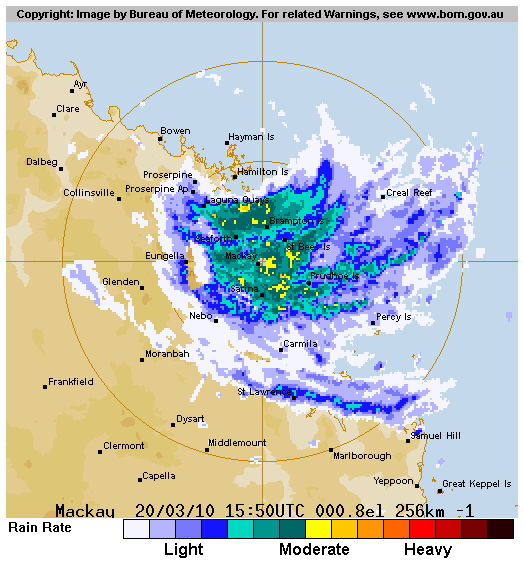
Image

Radar
0 likes   


Return to “2010”

Who is online

Users browsing this forum: No registered users and 76 guests